WEEKLY CLIMATE NEWS
22-26 April 2013
DataStreme Earth Climate System will return for Fall 2013 with
new Investigations files starting during Preview Week, Monday, 2 September 2013. All the current online website products will continue to
be available throughout the summer break period.
ITEMS
OF INTEREST
- Celebrate Earth Day --This Monday (22
April 2013) marks the 43rd Earth Day, first proposed by the late Senator
Gaylord Nelson of Wisconsin in 1970 as a teach-in to heighten awareness
of the environment. The Nelson Institute for Environmental Studies at
the University of Wisconsin-Madison has posted a website called "Gaylord Nelson and Earth Day: The Making of the Modern
Environmental Movement" that highlights Senator Nelson and his idea
became Earth Day. Several governmental websites provides links to various activities and resources planned for this
week, including a website maintained by the US Environmental Protection Agency (EPA). NOAA has a Earth Day 2013 website that describes how this agency honors Earth through its mission to "observe, predict, protect our changing planet." In addition to information on nearly 100 public events around the nation, this site also has a link where the official 2013 Earth Day poster and computer screen wallpaper can be downloaded.
- National Science Bowl set for next weekend -- The
US Department of Energy (DOE) National Science Bowl®, a nationwide
academic competition for middle and high school students will be held
this coming weekend (25-29 April 2013) in Washington, DC. This event
will test students' knowledge in all areas of science and is meant to
encourage high school students to excel in science and math and to
pursue careers in those fields. [DOE Office of Science]
- Celebrating Arbor Day -- This coming Friday, 26 April 2013, many locations across
the nation will celebrate Arbor Day, a day when the planting of trees
is encouraged. Arbor Day was originally proposed in 1872 by J. Sterling
Morton, Nebraska's first newspaper editor, and continues to be most
often celebrated by individual states on the last Friday in April.
However, since planting conditions vary greatly due to the state's
climate it may occur from September to May. In Arkansas, Arbor Day is
celebrated on the third Monday in March, but in Alaska, the date is the
third Monday in May. For your state's observance (and name of the
official state tree), please consult the National Arbor Day
Foundation.
CURRENT
CLIMATE STATUS
- March 2013 weather and climate for the nation and globe reviewed -- Scientists at the NOAA National Climatic Data Center
recently reported on their analysis of preliminary weather data collected during the month of March 2013:
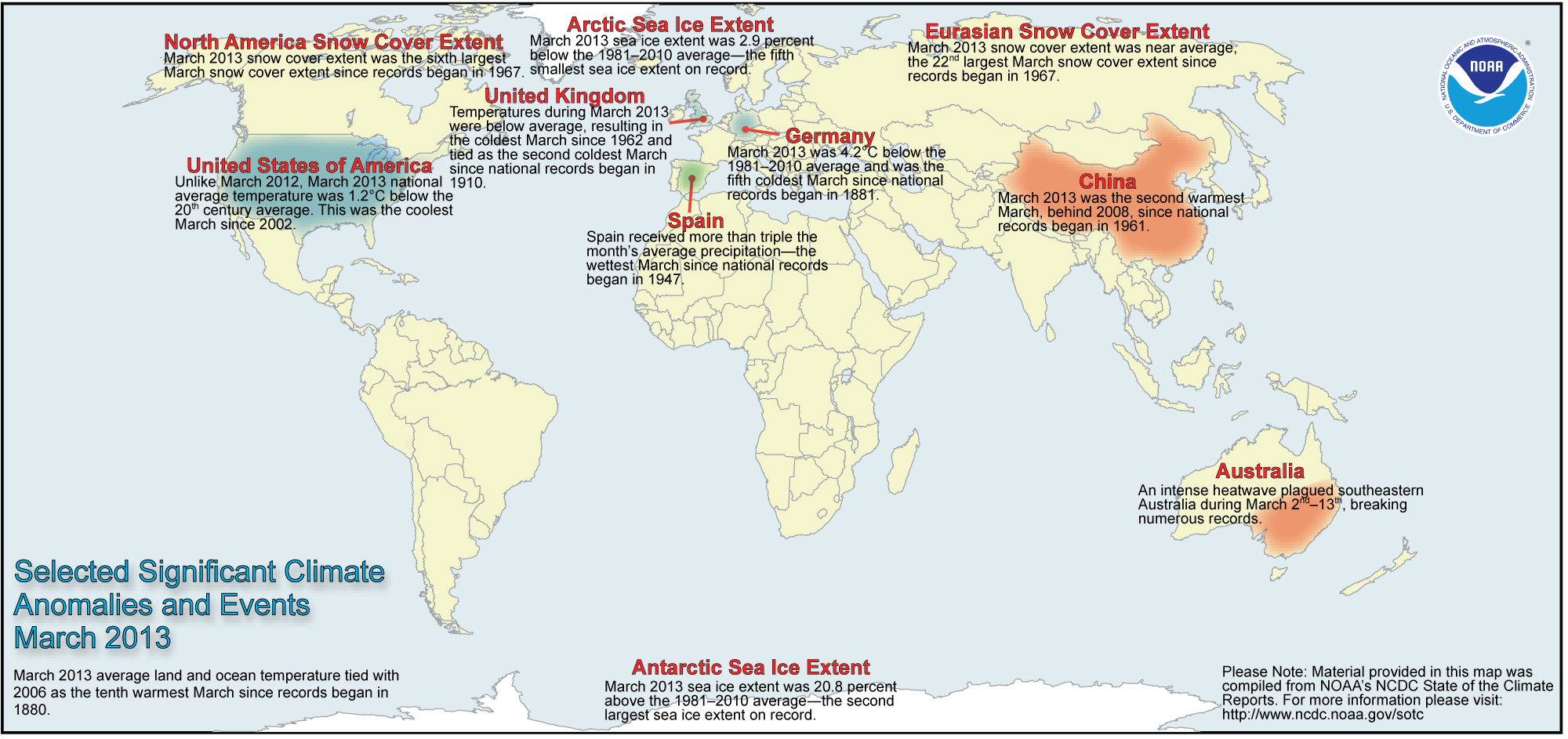
- National weather and climate -- When averaged across the coterminous United States, the monthly temperature for March 2013 was 40.8 degrees Fahrenheit, which was 0.9 Fahrenheit degrees below the 20th-century
(1901-2000) average. With the exception of northern New England, nearly all the states in the eastern half of the nation experienced below to much below average statewide temperatures. Eleven states across the Southeast, the Mid-South and the Midwest reported statewide temperatures that were within the ten lowest in 119 years, extending back to
1895 when comprehensive climate records became available nationwide. On the other hand, the states across the western third of the nation were above to much above in terms of statewide temperatures. Arizona, California and Nevada had statewide temperatures that ranked within the top 10 since 1895.
March 2013 was the fifth driest March on record across the coterminous US, with a nationwide average of 1.68 inches, which was 0.72 inch below the 20th-century average. More than half the states experienced below to much below average March precipitation. The statewide average March precipitation for Louisiana and Wyoming ranked within the top five driest March totals in 119 years. Only Minnesota had above average precipitation.
[NOAA
National Climatic Data Center]
The relatively cool month of March 2013 across a large section of the nation stands in stark contrast to one year ago when March 2012 was the record warmest March across the coterminous US. [NOAA NCDC News]
- Global temperatures and ice cover -- The combined global land and ocean surface temperature for March
2013 tied the temperature for March 2006 as the tenth highest for any March since sufficiently detailed global climate records
began in 1880. The global temperature for March 2013 was slightly more than one Fahrenheit degree above the 20th
century (1901-2000) average. The scientists noted that March 2013 was the 337th consecutive month in which the global temperature was above the 20th century average; the last below-average temperature for any month was February 1985. When considered separately,
the average land temperature was the 11th highest for any March since
1880, while the temperature over the oceans was the ninth highest for
March. Sea-surface temperatures across the eastern half of the
equatorial Pacific Ocean were slightly above average in March due to ENSO-neutral conditions (ENSO = El Niño/Southern Oscillation).
The researchers at the National Snow and Ice Data Center noted the areal extent of the Arctic sea ice
reached its annual maximum extent in mid March. The areal extent of this sea ice for March 2013 was
the fifth smallest since satellite surveillance began in 1979. On the
other hand, the extent of the Antarctic sea ice was the second largest
in the 35-year record. According to data from the Rutgers Global Snow Lab, the Northern Hemisphere snow cover extent for March was the 16th largest in the 47-year period of record. [NOAA/NCDC
State of the Climate] [NOAA
Environmental Visualization Laboratory] A global map of Selected Significant Climate Anomalies and Events for March 2013 is available from NCDC.
- March national drought report -- The National
Climate Data Center has posted its March
2013 drought report online. Using the Palmer Drought Severity
Index, approximately 24 percent of the coterminous United States
experienced severe to extreme drought conditions at the end of
March, while essentially none of the nation had severely to extremely wet
conditions at that time.
CURRENT
CLIMATE MONITORING
- Recent Antarctic climate and glacier changes appear to be near "upper bound" of normal -- An international team of researchers from the US, France and the Netherlands report that the rate of thinning of the glaciers on the edge of the Antarctic continent has accelerated during the last several decades and have contributed significantly to global sea level rise. However, the researchers cannot confidently attribute the rapid and dramatic changes to human-caused global warming from their analysis of ice cores. Some of the largest Antarctic warming has occurred during El Niño events, where anomalous atmospheric and oceanic circulation patterns result in a warm eastern equatorial Pacific Ocean. [University of Washington News]
- Describing the importance of "drought indicators" -- In a series pertaining to how scientists monitor the drought across the nation, NOAA's National Climatic Data Center (NCDC) has highlighted the various "drought indicators" used in addition to several quantitative indices, such as the Palmer Drought Severity Index, to describe the degree of soil moisture deficiency over a region. These indicators, which are considered in the production of the weekly US Drought Monitor, may include vegetation stress levels, agricultural productivity, streamflow, lake levels and incidents of wildfire in addition to accumulated precipitation totals. [NOAA/NCDC News]
- An All-Hazards Monitor -- This Web
portal provides the user information from NOAA on current environmental
events that may pose as hazards such as tropical weather, fire weather,
marine weather, severe weather, drought and floods. [NOAAWatch]
- Global and US Hazards/Climate Extremes -- A review and analysis of the global impacts of
various weather-related events, including drought, floods and storms
during the current month. [NCDC]
CLIMATE
FORECASTS
- New Seasonal Climate Outlooks released -- During the last week, forecasters at NOAA's Climate Prediction Center
(CPC) released their Three-Month (Seasonal) Climate Outlooks for the
three-months running from May through July 2013, which contains the
last month of meteorological spring and the first two months of two months of
meteorological summer. Specific details of their outlooks include:
- Temperature and precipitation outlooks -- According to their temperature outlook, most of the 48 coterminous United States should experience a high chance of above average temperatures for these three upcoming months, with the greatest probability of such an occurrence across the Southwest, centered on the Four Corners (Arizona, Utah, Colorado and New Mexico). South Central States and New England. Only the Northwest appears to have a good chance for below average temperatures. The rest of the "lower 48" were expected to have near equal chances of warmer or cooler than normal conditions. No areas would have below average temperatures.
Their precipitation outlook calls for better than even chances of dry conditions for May through July 2013 across a large section of the West, extending from the Pacific Northwest across the Intermountain West and the Rockies. The western slopes of the central Rockies in Utah and Colorado appeared to have the highest chance of drier than average weather conditions. The rest of the coterminous states should have equal chances of below and above average precipitation for late spring and early summer. [NOAA Climate Prediction Center] Outlooks for May are also available. A summary of the prognostic discussion of the outlook for non-technical users is available from CPC. These forecasts were based in part that the current ENSO-neutral conditions (ENSO = El Niño/Southern Oscillation) should continue through the end of summer in the Northern Hemisphere, where neither El Niño nor La Niña conditions should prevail.
- Seasonal Drought Outlook released -- The
forecasters at NOAA's Climate Prediction Center also released their US
Seasonal Drought Outlook that would run from mid April
through July 2013 in which drought conditions were expected to persist across most of the western half of the nation, in a region extending from the southern Plains westward and northward across the Rockies, the Great Basin and southern California. Expansion of drought conditions was anticipated across northern California and interior sections of the Northwest. Improvement was expected across the Southeast, the Ozark Plateau and the upper Midwest, along with some slight improvement across the central Plains. Note: a Seasonal Drought Outlook Discussion is included describing the forecasters' confidence.
CLIMATE
FORCING
- Sea level rise could be slowed by reducing certain atmospheric pollutants -- Researchers at the National Center for Atmospheric Research (NCAR) claim that cutting the emissions of four atmospheric pollutants could greatly slow the rise in global sea level by between 25 and 50 percent during the remainder of this century. The four atmospheric pollutants that were considered were methane, tropospheric ozone, hydrofluorocarbons and black carbon. [NSF News]
CLIMATE
AND SOCIETY
- Website for human dimensions of climate change -- An interagency effort within the US federal government that included
NOAA, the Bureau of Land Management and the US Forest Service, has
resulted in a website called HD.gov (for HumanDimensions.gov) that
provides users, such as natural resource managers, with information on
the human dimensions on a variety of topics of interest such as climate
change. [HD.gov]
- Earthweek -- Diary of the Planet [earthweek.com] Requires Adobe Acrobat Reader.

Historical Events:
- 22 April 2003...Tropical Storm Ana formed in the
southwestern North Atlantic Ocean, becoming the first Atlantic tropical
storm (since records began in 1871) to form during the month April.
Maximum sustained winds reached 50 mph. (The Weather Doctor)
- 23 April 1910...The temperature at the Civic Center in Los
Angeles, CA hit 100 degrees to establish an April record for the city.
(The Weather Channel)
- 23 April 1989...Salina, KS was the hot spot in the nation
with a high of 105 degrees. The high of 105 degrees established an
April record for the state of Kansas. A total of eighteen cities in the
central U.S. reported record high temperatures for the date. (The
National Weather Summary) (Storm Data) (The Weather Channel)
- 23 April 1996...One inch of snow on this day at Cleveland,
OH brought its seasonal snowfall to 101.1 inches -- the city snowiest
winter ever. The old record was 100.5 inches set in 1981-82.
(Intellicast)
- 24 April 2003...The temperature at Juneau, AK soared to a
maximum of 70 degrees, the earliest occurrence of a 70-degree reading
for the period of record in Alaska's capital city. (The Weather Doctor)
- 25 April 1875...New York City received three inches of
snow, the latest measurable snow of record for that location. (David
Ludlum)
- 25 April 1898...The temperature at Volcano Springs, CA hit
118 degrees to establish an U.S. record for the month of April. (The
Weather Channel)
- 27 April 1915...The temperature at Washington, DC hit 92
degrees, the highest ever in April. New York City hit 92 degrees as
well. (Intellicast)
- 27 April 1931...The temperature at Pahala, located on the
main island of Hawaii, soared to 100 degrees to establish a state high
temperature record. (The Weather Channel)
- 27 April 1960...The highest temperature ever recorded in
Thailand reached 112 degrees at Uttaradit, Thailand . (The Weather
Doctor)
- 27 April 1988...Mount Washington, NH reported seven ft of
snow in ten days, pushing their snowfall total for the month to 89.9
in., surpassing the previous record of 89.3 in. set in 1975. Records
have been kept at the Observatory on the summit since December 1932.
(The National Weather Summary) (Intellicast)
- 27 April 2003...The largest hail storm ever recorded at Key
West, FL was reported between 4:10 and 4:20 PM, hailstones ranging in
size from one-half inch up to one and three-quarter inches fell. It is
the eleventh recorded hail event (since 1871) at Key West. (The Weather
Doctor)
- 28 April 1973...The all-time record crest of the
Mississippi River at St. Louis, MO was recorded at 43.3 ft, exceeding
the former 1884 mark by 1.9 ft. (Intellicast) This record has since
been exceeded by a record flood level of 49.6 feet on 1 August 1993.
(National Weather Service)
Return to DataStreme
ECS website
Prepared by Edward J. Hopkins, Ph.D., email hopkins@meteor.wisc.edu
© Copyright, 2013, The American Meteorological Society.