WEEKLY CLIMATE NEWS
23-27 March 2015
ITEMS
OF INTEREST
- "World Meteorology Day" observed -- A celebration will be held on Monday,
23 March 2015 for World
Meteorology Day. This day is designated to celebrate the
anniversary of the establishment of the World Meteorological
Organization (WMO) on 23 March 1950. The WMO is an agency within the
United Nations.
This year's theme for World Meteorological Day
2015 is “Climate knowledge for climate action."
-
Phenological events of note -- While astronomical spring
commenced with the occurrence of the vernal equinox last Friday (20 March 2015), several reoccurring phenological events
also are used to note the onset of spring. These include:
-
Buzzards return to Hinckley -- According
to local reports from Hinckley, OH, spring occurred on Sunday morning
(15 March 2015) at 7:44 AM EDT when the first buzzard returned to roost
at the Cleveland Metroparks Hinckley Reservation. According to legend,
the buzzards return on the 15th of March of every year for nearly 200
years. [Cleveland.com]
- Swallows return to Capistrano -- Legend
indicates that swallows return to the Mission at San Juan Capistrano in
southern California every St. Joseph's Day (19 March). The return of
the swallows appears to be sporadic, with some reports of sightings
near the Mission. Increased urbanization around the Mission appears to keep the swallows away. However, the 57th annual Swallows Day
parade was held on Saturday 21 March 2015.
- Cherry Blossom Watch
in Washington, DC -- Many tourists descend upon Washington, DC during the
spring to view the sights, including the blossoming cherry trees that
line the Tidal Basin along the Potomac River. The National Park service
operates a website
that reports the status of the cherry blossoms in anticipation of the
103th annual Cherry Blossom Festival that is currently underway (Saturday, 28 March to Sunday, 12 April 2015). This site also has
a listing of the phenological observations for past bloom dates.
According to a recent update, experts expect that the trees should be
at peak bloom between 11-14 April, as cold weather continues across the Middle Atlantic States and delays the anticipated bloom that typically occurs at the start of April.
- Tsunami Awareness Week -- NOAA and the National Tsunami Hazard Mitigation Program (a partnership between NOAA, the United States Geological Survey, the Federal Emergency Management Agency, the National Science Foundation, and the 28 U.S. Coastal States, Territories, and Commonwealths) have designated this upcoming week (22-28 March 2015) as National Tsunami
Awareness Week.
Tsunami awareness training exercises will be conducted
on 25 March 2015 for the states and territories along the Pacific that is called Pacific Tsunami Exercise (PACIFEX
15) on 25 March, for the Southwest Caribbean called CARIBE WAVE/LANTEX15 and for the western North Atlantic (LANTEX15) Open houses will be held at the National Weather Service's tsunami
warning centers in Alaska and Hawaii, along with various community
activities in coastal states. The Alaska State House of Representatives has proclaimed
next Friday 27 March 2015 as Great Alaska Earthquake Remembrance Day in observance of the 51st anniversary of the series of devastating
tsunamis that struck southeastern Alaska following several earthquakes. The entire week is also Tsunami Preparedness Week in Alaska.
[Governor's
Office for State of Alaska]
Additional information is also available for last year's 50th anniversary of the Great Alaskan earthquake and tsunami of 1964. [NOAA Weather-Ready Nation]
- Accessing the national climatographies -- NOAA's
National Climatic Data Center (NCDC) has produced numerous
climatographies that are quantitative descriptions of climate that
include tables and charts portraying the characteristic values of
selected climatic elements at a station or over an area. Some of these
climatographies provide a variety of daily, monthly and annual normal
climate data for agricultural, transportation and other interests. This
week's Supplemental Information...In
Greater Depth provides the links to selected climatographies
from NCDC.
CURRENT
CLIMATE STATUS
- Review of global weather
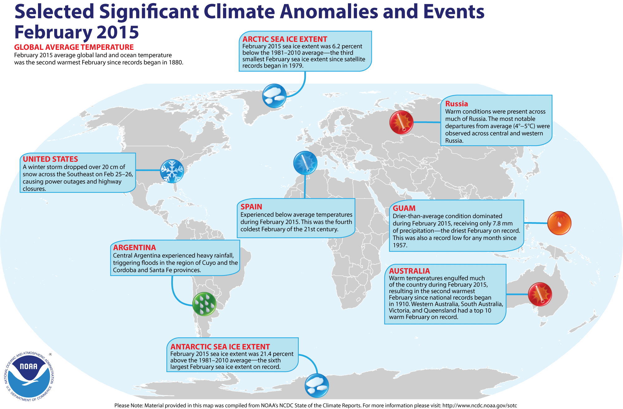
and climate for February 2015 -- Using preliminary data
collected from the global network of
surface weather stations, scientists at NOAA's National Climatic Data
Center have determined that the combined global land and ocean surface
temperature for February 2015 was 0.82 Celsius degrees above the 20th century (1901-2000) average, which was the second highest February temperature since comprehensive global climate records began in 1880. Only February 1998 was warmer. The average global
land surface temperature for February 2015 was the second highest on
record, behind February 2002. Global ocean surface temperature for this past month was the third highest in the 136-year period of record.
Furthermore, the three-months running from December 2014 through February 2015 that constitute meteorological winter in the Northern Hemisphere (and meteorological summer in the Southern Hemisphere) had the highest three-month average combined global temperature since 1880/81, with the Northern Hemisphere experiencing its warmest winter for both land and ocean and the Southern Hemisphere its fourth warmest summer. The global land surface temperature for these last three months tied the corresponding months in 2007/08 for the highest on record, while the December-February global ocean surface temperature was the third highest since 1880.
The scientists also noted that the monthly combined global (land-ocean) temperatures for nine of the last 12 months have either been the highest or second highest on record for their respective months.
[State of the
Climate/NCDC]
According to the National Snow and Ice Data Center, the
Arctic sea ice was the third smallest monthly extent for any February since satellite surveillance began in 1979. In late February 2015, Arctic sea ice extent appeared to have reached its annual maximum extent, which would represent the lowest maximum extent in the satellite-era. Sea ice extent around Antarctica was the sixth largest February sea ice extent on record.
The extent of the Northern Hemisphere snow cover during February 2015
was
the 14th smallest for the period of record that
started in 1967. [NOAA/NCDC Global Snow & Ice]
NCDC also provides a map showing the Global Significant Weather and Climate Events map for February 2015.
- A warm winter in Alaska -- While many areas across eastern North America experienced an unseasonably cold and snowy 2014/15 winter, the atmospheric circulation pattern that created these conditions was also responsible for unseasonably warm and dry winter conditions across western sections of the 48 contiguous United States and across Alaska. Maps of the winter temperature departures from the long-term averages across most of Alaska were as much as 10 Fahrenheit degrees above average. In addition, the sea surface temperatures across the Gulf of Alaska, the Bering Sea and the North Pacific close to the Aleutians were above average. [NOAA Climate.gov News]
CURRENT
CLIMATE MONITORING
- Glacial melting sends large amounts of freshwater into Gulf of Alaska -- Researchers from Oregon State University and the University of Alaska-Fairbanks report that melting glaciers along with regional precipitation over coastal sections of southern Alaska are emptying enormous quantities of freshwater into the Gulf of Alaska. They calculate that the freshwater discharge entering the Gulf would be equivalent to that from the sixth largest coastal river in the world if it emerged as a single stream. This quantity freshwater would affect marine biology along with the temperature, salinity and ocean currents within the Gulf of Alaska. The researchers based their report upon analysis of data collected from satellites, precipitation networks and hydrological sources. [Oregon State University News]
- Tracking historic storms across eastern Lake Ontario -- Using funding from NOAA's Sea Grant College Program, the New York Sea Grant is creating a climatological event database of historic storms along the eastern shore of Lake Ontario that is designed to help communities assess risk projection and increase their storm event resiliency. Focus areas in this pilot project include some fragile dunes along the Lake near Oswego and a barrier island near Sodus Bay. [NOAA Sea Grant News]
- Nation's new geosynchronous environmental satellite awaits launch next year -- NOAA officials are preparing for the launch of the agency's Geostationary Operational Environmental Satellite-R Series (GOES-R) spacecraft in March 2016. This GOES-R spacecraft is intended to improve weather forecasting by obtaining near real-time weather observations more quickly from across the Western Hemisphere from its geosynchronous orbit approximately 22,000 miles above the Earth's surface. A video and a fact sheet entitled "Top 5 Reasons Why NOAA's GOES-R Satellite Matters" provide background information on this new spacecraft. [NOAA News]
CLIMATE
FORCING
- Record snowstorms not necessary proof that "global warming" is not occurring -- As part of the Third National Climate Assessment, a "state of the science" review of climate change and extreme storms in 2014, a group of scientists concluded that record snowstorms are possible as global temperatures increase: From their analysis of historical record snowstorms between 1961 and 2010, they found that approximately 35 percent of snow seasons that produced extreme snow events were warmer than average and 30 percent were drier than average. [NOAA Climate.gov News Features]
- Ocean pipes could lead to a warming climate -- In a study conducted by several scientists for the Carnegie Institute, the types of vertical ocean pipes that were proposed to move seawater to the surface so as to garner different potential climate benefits could in fact drastically increase global warming. One of the proposed strategies would have the ocean pipes facilitate direct physical cooling of the surface ocean by replacing warm surface ocean waters with colder, deeper waters. Another strategy would employ Ocean Thermal Energy Conversion (OTEC) that involves utilizing the temperature difference between deeper and shallower water to power a heat engine and produce clean electricity. [Carnegie Science News]
CLIMATE
FORECASTS
- New Seasonal Climate Outlooks released for spring --
Late last week forecasters at NOAA's Climate Prediction Center
(CPC) released their Three-Month (Seasonal) Climate Outlooks for the
three-months running from April through June 2015, which contains the
last two months of meteorological spring and the first month of
meteorological summer. [NOAA News] Specific details include:
- Temperature and precipitation outlooks -- According to their temperature outlook, the West Coast States along with the northern Rockies, the northern Plains and the Upper Midwest should experience a high chance of above average spring and early summer temperatures, with the greatest probability of such an occurrence extending along the Washington, Oregon and California coasts. Conversely, a large area of Texas and adjacent sections of New Mexico and Oklahoma appear to have a good chance for below average temperatures. Elsewhere, near equal chances of warmer or cooler than normal conditions were foreseen across the 48 contiguous United States.
Their precipitation outlook calls for better than even chances of dry spring conditions for the Pacific Northwest and the Upper Midwest that includes the western Great Lakes. The southern Rockies along with the Colorado Plateau and the Great Basin in the Southwest and a large section of the Gulf Coast and Southeast should have above even chances for a wet spring and early summer. The rest of the coterminous states should have equal chances of below and above average spring precipitation. Outlooks for April are also available. A summary of the prognostic discussion of the outlook for non-technical users is available from CPC. These forecasts were based in part that the current El Niño conditions should prevail through at least meteorological summer (June through August) in the Northern Hemisphere.
- Seasonal Drought Outlook released -- The CPC's US
Seasonal Drought Outlook was released for late March
through June 2015 that indicates a persistence or expansion of drought conditions across a large sections of the West and across the Upper Midwest. The forecasters foresee an improvement in the drought conditions across sections of the central and southern Plains, with some areas being removed from drought status. Note: a Seasonal Drought Outlook Discussion is included describing the forecasters' confidence.
- Spring flood outlook for nation -- Forecasters
with the National Weather Service's Hydrologic Information Center
issued their National Hydrologic Assessment for Spring 2015 that
includes minor to moderate flooding across the Northeast, the Midwest and sections of the Southeast. The greatest threat appears to be across eastern New England where an above average snowpack remains, in New York State bordering Lake Ontario and across the lower Ohio, the lower Missouri and the mid-Mississippi Valleys in the Midwest. [National
Weather Service]
CLIMATE
AND SOCIETY
- Land cover changes along nation's coastlines described -- The NOAA Office of Coastal Management recently issued five regional studies as part of the Coastal Change Analysis Program (C-CAP) that focus upon the changes in the land cover across areas of the nation surrounding the Great Lakes, Gulf Coast, Northeast, Southeast and West Coast from 1996 to 2010. These C-CAP reports are intended to show community officials how earlier land use decisions and changes in climate affect land cover in these coastal regions. [NOAA News]
- Earthweek -- Diary of the Planet [earthweek.com]
Requires Adobe Acrobat Reader.

Concept of the Week: Seawater Salinity
and Carbon Dioxide
The contemporary concern regarding global climate change has
caused scientists to study the various factors that govern the ocean's
ability to absorb atmospheric carbon dioxide. Concentrations of
atmospheric carbon dioxide, a greenhouse gas, are on the rise primarily
because of increased burning of fossil fuels. Higher levels of
atmospheric carbon dioxide may be contributing to increased global
temperatures, a condition often identified as global warming. The
ocean's role in regulating the concentration of atmospheric carbon
dioxide depends on the temperature, salinity, and biological components
of surface waters.
Studies show that the ocean's ability to absorb carbon dioxide
is primarily temperature dependent. As noted in Chapter 8 of your
textbook, gases are more soluble in cold seawater than warm seawater.
Hence, changes in sea surface temperature affect the ability of the
ocean to absorb carbon dioxide. We also found in Chapter 1,
photosynthetic organisms assimilate carbon dioxide and release oxygen.
Through cellular respiration, all organisms release carbon dioxide.
Therefore, biological activity affects the ocean's ability to
absorption of atmospheric carbon dioxide.
What about the effects of changes in salinity on the ocean's
uptake of atmospheric carbon dioxide? Research from the Pacific Ocean
near Hawaii provides some insight on this question. For nearly 20
years, scientists have been collecting physical, chemical and
biological data through a large column of ocean water at Station ALOHA,
a sampling site about 100 km (62 mi) north of Oahu that appears
representative of oceanic conditions in the central North Pacific. In
2003, David M. Karl, a biogeochemist at the University of Hawaii in
Honolulu, reported a decline in the rate at which surface ocean waters
were absorbing carbon dioxide from the atmosphere. In 2001, the rate of
carbon dioxide uptake was only about 15% of the rate in 1989. Why the
change in carbon dioxide uptake? In this region of the Pacific north of
Hawaii, sea surface temperatures showed no significant change during
the period of observation but precipitation decreased and evaporation
increased. Less precipitation associated with drought coupled with
higher rates of evaporation caused the surface water salinity at ALOHA
to increase by about 1%. Increasing salinity inhibits water's ability
to absorb gases including carbon dioxide. Karl and his colleagues
attribute 40% of the decline in the ocean's carbon dioxide uptake to
the saltier waters. The balance of the decline may be due to changes in
biological productivity or ocean mixing.
Projected changes in global climate indicate significant
changes in precipitation around the globe including reduced
precipitation over various large areas of the oceans, resulting in
potential "drought" conditions. Since changes in oceanic salinity
result from changes in precipitation, the contribution that salinity
plays on future assimilation of atmospheric carbon dioxide by the ocean
also becomes an important consideration.
Concept of the Week: Questions
Place your responses on the Chapter Progress Response Form
provided in the Study Guide.
- With rising sea surface temperatures, the rate of
evaporation of seawater [(increases),
(decreases)].
- With increasing salinity and constant temperature, the
amount of atmospheric carbon dioxide that is taken up by ocean water [(increases),
(decreases)].
Historical Events:
- 23 March 1912...Residents of Kansas City, MO began to dig
out from a storm that produced 25 inches of snow in 24 hours . The
snowfall total was nearly twice that of any other storm of modern
record in Kansas City before or since that time. A record 40 inches of
snow fell during the month of March that year, and the total for the
winter season of 67 inches was also a record. By late February of that
year, Kansas City had received just six inches of snow. Olathe, KS
received 37 inches of snow in the snowstorm, establishing a single
storm record for the state of Kansas. (23rd-24th) (Intellicast) (The
Kansas City Weather Almanac) (The Weather Channel)
- 24 March 1993...What was to be called "the winter of the
return of the big snows" continued to set records. Boston, MA had 8.6
inches of snow on this day to push its monthly total to 38.9 inches
that set a new March monthly snowfall record. The old record was 33.0
inches set in 1916. Boston's seasonal snowfall total now stood at 81.7
inches, the third snowiest winter season on record. (Intellicast)
- 25 March 1914...Society Hill, SC was buried under 18 inches
of snow, establishing a state record. (Sandra and TI Richard Sanders -
1987)
- 25 March 1975...The town of Sandberg reported a wind gust
to 101 mph, a record for the state of California. (The Weather Channel)
- 26 March 1913...The Ohio River Basin flood reached a peak.
Ten-inch rains over a wide area of the Ohio River Basin inundated
cities in Ohio, drowning 467 persons, and causing 147 million dollars
damage. The Miami River at Dayton reached a level eight feet higher
than ever before. The flood, caused by warm weather and heavy rains,
was the second mostly deadly of record for the nation. (David Ludlum)
- 26 March 1930...A two-day snowfall of 19.2 inches at
Chicago, IL was the greatest modern snowfall on the record books at
Chicago. (Intellicast)
- 26 March 1954...The temperature at Allakaket, AK plunged to
69 degrees below zero, setting a record for the lowest temperature ever
for March. (The Weather Channel)
- 26-28 March 2004...The first ever confirmed hurricane in the
South Atlantic Ocean, named Catarina, struck the coast of the Brazilian
states of Santa Catarina and Rio Grande do Sul with heavy rains and
winds, before dissipating over land late on the 28th. (The Weather
Doctor)
- 27 March 1931...A blizzard that struck western Kansas and
adjoining states was called the "worst since January 1888". The low
temperature of 3 degrees below zero, which was reached during the
blizzard, stands as the lowest temperature recorded so late in the
season. (Intellicast)
- 27-28 March 1964...The most powerful earthquake in US
history, the Good Friday Earthquake, rocked south central Alaska,
killing 125 people and causing $311 million in property damage,
especially to the city of Anchorage. The earthquake in Prince William
Sound, which had a magnitude of 9.2 on the Richter scale, caused some
landmasses to be thrust upward locally as much as 80 feet, while
elsewhere land sank as much as 8 feet. This earthquake and submarine
landslides also created a tsunami that produced extensive coastal
damage. A landslide at Valdez Inlet in Alaska generated a tsunami that
reached a height of 220 feet in the inlet. A major surge wave that was
approximately 100 ft above low tide caused major damage to Whittier
(where 13 died) and other coastal communities in Alaska. The first wave
took more than 5 hours to reach the Hawaiian Islands where a 10-foot
wave was detected, while a wave that was 14.8 feet above high tide
level traveled along portions of the West Coast, reaching northern
California 4 hours after the earthquake. Nearly 10,000 people jammed
beaches at San Francisco to view the possible tsunami, but no
high-amplitude waves hit those beaches. Tsunami damage reached Crescent
City in northern California. Tens of thousands of aftershocks indicated
that the region of faulting extended about 600 miles. The Alaska
Tsunami Warning Center was established in the wake of this disaster,
with a mission to warn Alaskan communities of the threat from tsunamis.
[See the 1964
Prince William Sound Tsunami page from the University of
Washington.] (Accord's Weather Guide Calendar) (US Coast Guard
Historians Office)
- 27 March 1984...A strong storm system traversing northern
Texas pulled very hot air northeastward into southern Texas. The
temperature at Brownsville, TX soared to 106 degrees, which broke not
only the monthly record high temperature but the all-time record as
well. Cotulla, TX reached 108 degrees, equaling the March record for
the U.S. (The Weather Channel) (Intellicast)
- 27-28 March 2009...A blizzard moving across the southern
Plains was responsible for new 24-hour snowfall records for the states
of Kansas, Oklahoma and Texas. A 30.0-inch snowfall at Pratt eclipsed
the previous Kansas 24-hour record of 24 inches set at Norcator on 26
October 1996. Freedom and Woodward in Oklahoma replaced the 24.0-inch
state snowfall record at Buffalo on 21 February 1971. In Texas, 25.0
inches fell at Follett, which broke the previous 24.0-inch record at
Plainview set on 4 February 1971. (Accord Weather Guide Calendar)
- 28 March 1902...McMinnville, TN (elevation 900 feet)
received 11.00 inches of precipitation, setting a 24-hour precipitation
record for the Volunteer State. (National Climate Data Center).
- 28 March 1955...Florida's latest measurable snowfall occurred
at Marianna when one inch of snow fell. Ground is whitened further
south in Panama City. (The Weather Doctor)
- 29 March 1879...The temperature at Los Angeles, CA climbed
to 99 degrees, which was 3 degrees higher than any other March day had
ever reached in the city. (Intellicast)
- 29 March 1886...Atlanta, GA was drenched with a record 7.36
inches of rain in 24 hours. (The Weather Channel)
- 29 March 1920...Clear Spring, MD received 31 inches of snow
in 24 hours to establish a state record. (Sandra and TI Richard Sanders
- 1987)
- 29 March 1942...The "Palm Sunday snowstorm" buried
Baltimore, MD under 22 inches of snow in 24 hours. This was the
heaviest 24-hour snowfall ever for the city for the month of March as
well as the heaviest snow for so late in the season. (Intellicast)
- 29 March 1945...Providence, RI hit 90 degrees to establish
a March record for the New England area. (The Weather Channel)
- 30 March 1977...Hartford, CT hit 87 degrees to establish a
record for the month of March. (The Weather Channel)
Return to DataStreme
ECS website
Prepared by Edward J. Hopkins, Ph.D., email hopkins@meteor.wisc.edu
© Copyright, 2015, The American Meteorological Society.