WEEKLY CLIMATE NEWS
WEEK ONE: 25-29 January 2016
ITEMS
OF INTEREST
- Uncommon alignment of five planets appears in the morning skies -- During the next month, sky watchers should be able to view five planets (Mercury, Venus, Saturn, Mars and Jupiter) in the predawn skies, if weather conditions are favorable. The simultaneous appearance of the five visible planets in the night sky is not common, as the last occurrence was in January 2005, while the next viewing opportunity should be in the evening sky in beginning in late July. A sky map is available to assist viewing. [NASA Jet Propulsion Laboratory News]
- An El Niño and La Niña FAQ site posted -- Since many recent unusual weather and climate events have been attributed to the ongoing strong El Niño event, the staff of NOAA Climate.gov has posted a feature that provides answers to the frequently asked questions (FAQ) concerning El Niño and its counterpart, La Niña. [NOAA Climate.gov News]
- Accessing and interpreting climate data --
If you would like to obtain a variety of climate data for your home
town or state that are available from the National Weather Service,
please read this week's Supplemental
Information…In Greater Depth. This Supplemental not only
identifies some of the sites to find the data, but also provides you
with a brief explanation of the terminology used to identify the
climate data.
CURRENT
CLIMATE STATUS
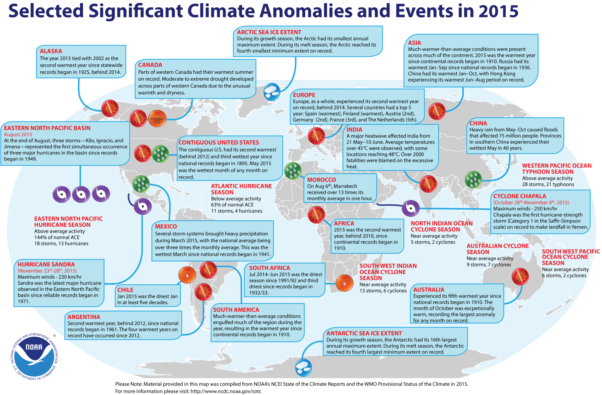
- Global weather and climate for 2015 reviewed -- Scientists at NOAA's National Centers for Environmental Information (NCEI) reported that
based upon their preliminary analysis of worldwide land and ocean
surface temperature data, the calendar year of 2015 was the warmest since sufficiently detailed world-wide climate records began in 1880. The average global temperature across land and ocean surface areas for 2015 was 1.62 Fahrenheit degrees above the 20th century (1901-2000) average of 57.0 degrees Fahrenheit), exceeding the previous record temperature departure set in 2014 by 0.29 Fahrenheit degrees. When considered separately, global land surface temperature for 2015 was 2.39 Fahrenheit degrees above the 20th century average, which surpassed the previous annual land records set in 2007 and 2010 by the largest margin (0.45 Fahrenheit degrees) on record . The annually-averaged temperature for ocean surfaces in 2015 was 1.33 Fahrenheit degrees higher than the 20th century average, which also set a record high departure.
The scientists
suggested that this past year's near-record strong El Niño event (an anomalous
atmospheric and oceanic circulation regime favoring warm or cool waters in the
equatorial Eastern Pacific Ocean) contributed to the record warmth of the near-surface waters of the global oceans.
Arctic sea ice remained well below the long-term averages that cover the period of record beginning in 1979 when satellite surveillance of the polar ice caps began. During the winter growth season, the sea ice covering the Arctic experienced its smallest annual maximum extent, while at the end of the summer melt season, the sea ice was the fourth smallest on record. Conversely,
sea ice around Antarctica was well above average. During the winter growth season, the ice around that content reached the 16th annual maximum extent for the satellite period, while during the summer melt season, the ice extent was the third largest minimum on record.
The scientists also note that the preliminary global precipitation data
from land-based stations indicate 2015 was slightly below (by 0.8 inches) long-term averages across the land areas. Although some areas of the planet were exceptionally wet, others
experienced extreme drought conditions. [NOAA/NCEI
State of the Climate]
NCEI also provides a map showing the Global Significant Weather and Climate Events map for 2015.
Using a slightly different methodology for averaging global surface
temperatures, scientists at NASA's Goddard Institute for Space Studies
(GISS) reported that the global average temperature for 2015 also was the
highest reading since 1880. [NASA
GISS]
An animated loop of 13 global temperature anomaly maps showing the spatial distribution of the differences between observed and normal temperatures recaps 2015, commencing with the 2015 annual average and then indexing through each month, running from January through December. A compressed (or zip) file containing the individual maps is available. [NOAA Climate.gov News]
NCEI also produced a summary of the global weather and climate for December 2015.
The December 2015 globally-averaged temperature across both land and ocean surfaces was 2.00 Fahrenheit degrees above the 20th century average, which represents the highest temperature departure for any month since 1880. [NOAA/NCEI
State of the Climate]
CURRENT
CLIMATE MONITORING
- A view of 136-year history of global temperatures in 30 seconds -- A 30-second animation of the variations in the global distribution of annual surface temperatures over both ocean and land beginning in 1880 and continuing through 2015 has been produced from world-wide climate data collected and analyzed at the NOAA National Climatic Data Center. Attention is turned to the increases in global temperature over the last four decades, culminating in the highest annual global temperature in 2015. [NOAA Environmental Visualization Laboratory]
- Record snowstorms and a warming climate -- This past weekend's record snowstorm that slammed the Middle Atlantic States has caused some people to wonder if record snowstorms may be proof the global warming is not happening. A feature appearing on NOAA's Climate.gov site notes that "snowstorms remain quite possible, and natural climate patterns and random variability will still lead to winters that are unusually cold and snowy in different locations."[NOAA Climate.gov News]
- Current El Niño event could be approaching its peak -- One of the indicators of an El Niño event is the magnitude of the sea surface height anomalies over the equatorial Pacific Ocean, which represent the differences in the observed height of sea level over these sections of the Pacific and the long-term averages. A sequence of 13 images of the sea surface height anomalies across the Pacific Ocean basin obtained was made from altimetry data collected from NASA's Jason-2 spacecraft for the period beginning in mid January 2015 and running through January 2016. [NASA Earth Observatory]
- Amount of heat accumulating in oceans doubles in recent decades -- A team of scientists from NOAA, the US Department of Energy's Lawrence Livermore National Laboratory and several universities recently reported that they have determined that approximately one-half of the increase in global ocean heat content since 1865 has occurred during the last two decades. The researchers also note that about one third of the ocean heat content increase has been in the deeper ocean. They based their conclusions on their analysis of ocean temperature observations ranging from those obtained from the historic H.M.S. Challenger 1872-1876 expedition to the modern ARGO robotic profiling floats and upon a large suite of climate models. [NOAA Office of Oceanic & Atmospheric Research News]
- Jason-3 satellite successfully launched to monitor global sea level changes and storm intensities -- At the start of last week, NOAA and NASA jointly announced the successful launching of a joint USA-European satellite mission called Jason-3 from California's Vandenberg Air Force Base that will have sensors that will make highly detailed measurements of sea-level on Earth in order to gain insight into ocean circulation and climate change. In addition, the instruments should help forecast tropical cyclones as they form and travel over the tropical ocean basins. Jason-3 was placed into an orbit approximately 830 miles above the Earth's surface and will monitor approximately 95 percent of the ice-free oceans. The spacecraft will undergo a six-month phase to test the satellite's instruments in orbit before officially joining Jason-2, which was launched in 2008. [NOAA News] A 30-second video of the launch of Jason-3 is available. [NASA Jet Propulsion Laboratory News]
- Balloon launched from Antarctica to study the Sun -- A helium-filled scientific balloon was launched from Antarctica's McMurdo station at the start of last week carrying the Gamma-Ray Imager/Polarimeter for Solar flares, or GRIPS, payload. This balloon, which was to reach an altitude of approximately 130,000 feet, is expected to be carried by the stratospheric winds circulating around the South Pole for at least two weeks, during which time the GRIPS instrument would be observing gamma rays, or extremely high-energy radiation released by solar flares emanating from the Sun.
[NASA Goddard Space Flight Center Feature]
CLIMATE
FORCING
- Regional responses of temperature to cumulative carbon dioxide emissions are quantified -- Researchers from Concordia University in Montreal, Quebec and Ouranos, a Montreal-based private non-profit consortium on regional climatology, have generated a map showing the geographic distribution of the temperature increases over the past century caused by the accumulation of carbon dioxide emissions into the atmosphere in different regions around the world. These researchers used the results of simulations run on 12 global climate models, finding temperature increases in many areas responding linearly to cumulative emissions. [NOAA News]
- Clouds over Amazon rainforests could be affected by storms and ozone -- An international team of researchers led by a meteorology professor from Penn State University report that some thunderstorms that develop over Brazil's Amazon Valley transport atmospheric ozone molecules into the canopy of the central Amazon rainforest, thereby influencing chemical processes that ultimately affect cloud formation over the rainforests. These results were based upon a nine-month monitoring of trace gases, including ozone, and various meteorological variables, such as precipitation and wind speed, under the canopy of the rainforest. The researchers claim that their findings could help improve climate prediction models by being able to more accurately gauge the Amazon's impact on future global weather patterns. [Penn State News]
- More powerful "superstorms" could be produced by warmer oceans -- Scientists at the University of Maryland's Earth System Science Interdisciplinary Center and at NASA Goddard Space Flight Center report that their simulations of weather patterns using a computer model indicate that a warmer Atlantic Ocean could substantially boost the destructive power of a future "superstorm" such as Sandy. The researchers simulated the weather patterns that created Sandy, but with a warmer sea surface temperature that would be associated with twice the current concentration of atmospheric carbon dioxide. These simulated storms were as much as 160 percent more destructive than Sandy. [College of Computer, Mathematical, & Natural Sciences, University of Maryland News]
- Abrupt shift in global climate traced as Ice Age glaciers began to retreat -- Earth scientists at Columbia University's Lamont-Doherty Earth Observatory have been reconstructing the long-term movement of the Intertropical Convergence Zone (ITCZ), or the zone where the large scale atmospheric flow patterns from the Northern and Southern Hemisphere converge and form a band of rainshowers and thunderstorms that essentially encircle the globe along what is also referred to as the "thermal equator." The researchers tracked the position of the ITCZ over the last 150,000 years from isotopic analysis using the thorium-232 isotopes in ocean floor sediment cores collected from three equatorial Pacific Ocean locations near the Line Islands south of Hawaii. During this time, the ITCZ that had been to the north of the Equator moved rapidly south toward the Equator and then back to the north as glaciers in the Northern Hemisphere waxed and waned. [Lamont-Doherty Earth Observatory News]
CLIMATE
FORECASTS
- Seasonal weather outlook released -- Late last week,
forecasters at the NOAA Climate Prediction Center released their new national Seasonal
Outlook for the next three months of 2016 (February-April) that includes the last month of meteorological winter (December-February) and the first two months of meteorological spring (March-May). Specific details of their outlooks include:
- Temperature and precipitation outlooks -- According to their temperature outlook, the West Coast along with the northern tier of states extending from the Pacific Northwest to New England should experience a high chance of above average temperatures for these three upcoming months.
The greatest probability of such an occurrence is to be found across the Pacific Northwest and the Upper Midwest. Conversely, sections of the southern tier of states from the southern Rockies to the northern Florida were considered to have a better than average chance of below average late winter-early spring temperatures. Southern Texas would have the greatest chance of chilly weather. The outlook indicates that the remainder of the 48 contiguous states would have nearly equal chances of warmer or cooler than normal conditions.
Their precipitation outlook calls for sections of the Northwest, primarily across interior Washington and Idaho along with sections of the Midwest centered on the Great Lakes to have a better than even chance of below average precipitation for the upcoming three months of 2016.
Conversely, the Southwest and the Southeast were considered to be under a better than even chance of above average precipitation. Those areas in the Southwest extending from southern California eastward to west Texas and across the Florida Peninsula would have the best chance of wet weather. Elsewhere, a large area of the coterminous states should have essentially equal chances of below and above average precipitation for the end of winter and the first two months of meteorological spring.
A summary of the prognostic discussion of the 3-month outlook for non-technical users is available from CPC. These forecasts were based in part that assuming that the strong El Niño event should have peaked, with a transition to an ENSO-neutral situation possibly occurring by late spring or early summer of 2016 (in the Northern Hemisphere) when neither El Niño nor La Niña conditions would prevail. A description is also provided as how to read these 3-class, 3-month Outlook maps.
- Seasonal Drought Outlook -- The
forecasters at NOAA's Climate Prediction Center also released their US
Seasonal Drought Outlook last week that would run from mid-January through April 2016. Their outlook would call for persistence or the development of extensive drought conditions across the interior Northwest, primarily across eastern Washington, central and eastern Oregon, Idaho and western Montana. Sections of California, Nevada, southern Oregon and the northern Utah currently experiencing drought conditions could see continuation of drought conditions, with a few areas across the West seeing sufficient improvement that they would possibly be removed from drought status. Sections of southern New England also could see an end to drought conditions. Note: a Seasonal Drought Outlook Discussion is included describing the forecasters' confidence.
CLIMATE
AND SOCIETY
- National Disaster Resilience Competition winners receive their awards -- Late last week the U.S. Department of Housing and Urban Development (HUD) Secretary and the Rockefeller Foundation announced that a total of $1 billion was being awarded for funding resilient infrastructure and housing projects to a combination of 13 states and communities that were impacted by major Presidentially-declared disasters between 2011 and 2013. [US Dept. of Housing and Urban Development]
- Earthweek -- Diary of the Planet [earthweek.com]
REPORTS FROM THE FIELD --
A request: If you have some climate-related experience that
you would like to share with other DataStreme Earth's Climate System
participants, please send them to the email address appearing at the
bottom of this document for possible inclusion in a News file. Thank
you. EJH
Concept of the Week: Touring the DataStreme Earth's
Climate System RealTime Climate Portal Website
NOTE: This Concept for the Week is a repeat of that
which appeared in last week's Weekly Climate News.
Welcome to DataStreme Earth's Climate System (ECS)! The Earth's Climate System RealTime Climate Portal is an integral component of the DataStreme ECS (Earth's Climate System) course. The website is intended to deliver a wealth of climate information that is both pertinent to the course as well as being a reference site for you as you study Earth's climate system. The webpage is arranged in several sections. On Monday of each week of the course, we will post the current Weekly Climate News that includes Climate in the News (a summary listing of recent events related to climate), Concept of the Week (an in-depth analysis of some topic related to climate in the Earth system), and Historical Events (a list of past events important in the understanding of climatology). When appropriate, Supplemental Information...In Greater Depth will be provided on some topic related to the principal theme of the week.
You will use the RealTime Climate Portal to access and download the "Current Climate Studies" that complement your Climate Studies Investigations Manual. These materials should also be available Monday morning. Click the appropriate links to download and print these electronic components of the investigations as well as your Chapter, Investigations and Current Climate Studies Response forms.
Beyond these course Learning Files, sections include Climate
Information, Climate Variability, Climate
Change, Societal Interactions and Climate Policy, and Extras. As the titles suggest, there are
multiple uses for climate data and their interpretation. Here we
explore some examples of the information provided in the various
sections of the RealTime Climate Portal.
The Climate Information section includes
access to weather data, the raw material of climate synthesis, from the
United States and the world under the heading "Observations and Data."
Under this heading, click on "U.S. and World Weather Data." This
National Oceanic and Atmospheric Administration (NOAA) page first
directs you to "United States Weather" and provides channels to current
weather data as well as radar graphics, weather maps, and aviation and
marine weather. It then leads you to International Weather
Conditions.
The second major subdivision of the RealTime Climate Portal encompasses Climate Variability. Climatic variability refers to
the fluctuations and oscillations that may occur within the climate
system at temporal and spatial scales beyond that of individual weather
events. Select the link, "NOAA El Niño Page". The page that appears
provides access to a wealth of background and information on El Niño
and La Niña, including the animation showing sea surface temperatures
(SST) in the tropical Pacific during recent months. To the left of the
animation, click on "What's happening today?" The page of current
tropical Pacific conditions that appears shows a small map to the
right. Click on that map and again anywhere on the subsequent set of
map panels to get an enlarged view of the latest conditions of SST and
anomalies.
The third major section of the RealTime Climate Portal is termed Climate
Change. Here we provide links to information and analyses
that primarily focus on anthropogenic (human-made) change processes and
results in the climate system. That prominently includes the
Intergovernmental Panel on Climate Change's ("IPCC") latest classic
report on atmospheric greenhouse gas emissions and their effects. Also
linked are modeling results ("Models") based on those studies.
The last major section of the RealTime Climate Portal is titled Societal
Interactions and Climate Policy. This block contains
information on the impacts of projected change on human societies
around the world, beyond that listed in the IPCC report, and the
international actions and debates regarding those issues. Select and
click on "National Climate Assessment (NCA3) Highlights" in this section.
This webpage introduces you to the latest comprehensive and
authoritative report on climate change and its impacts in the United
States, now and in the future. You will be directed to this report
several times in this course.
Completing the RealTime Climate Portal is the Extras section of additional handy information for the course and individual
study such as dictionaries of terms, maps and materials. Choose and
examine one of the Climate Literacy links. This document has recently been developed and
released by NOAA to provide an overview of general concepts and
information the general public and especially students should be aware
of regarding the climate and the climate debate.
Concept of the
Week: Questions
- The first Climate Information link,
"NOAA's Climate.gov", shows the Global Climate Dashboard where
several graphs display Earth's temperature, atmospheric carbon dioxide
level, spring snow cover, etc. with a time slider than can be set to
display from [(1800)(1880)(1940)] to the latest data in 2015.
- Under the Societal Interactions and Climate Policy section, click the "Global Resilience Toolkit" link. The Toolkit has been designed to aid in working through climate change issues by communities. The first step in using this toolkit is to [(Investigate options)(Identify the Problem)].
Historical Events:
- 25 January 1821...People were able to walk across the frozen Hudson River between Hoboken and New York City. Entrepreneurs sold coffee on the river to warm pedestrians. (National Weather Service files)
- 25 January 1965...Alta, UT was in the midst of a storm that
left the town buried under 105 inches of snow establishing a record for
the state. (David Ludlum)
- 26 January 1884...The coldest day on Canada's Prince Edward
Island occurred when the temperature at Kilmahumaig, PEI fell to 35
degrees below zero. (The Weather Doctor)
- 27 January 1940...Florida had a 3-day long freeze with the
lowest temperatures ever in January. Mason, FL dropped to 8 degrees.
Eleven million boxes of citrus were damaged, resulting in a 10
million-dollar loss. Further north, Georgia's record low temperature of
17 degrees below zero was set near Calhoun. (Intellicast)
- 27 January 1994...A frigid arctic air was in place over New
England and New York as a massive 1052-millibar (31.06 inches of
mercury) high pressure provided ideal radiational cooling. Crown Point,
NY dipped to 48 degrees below zero and Shoreham, VT shivered with 46
degrees below zero, Burlington, VT broke its old record daily low by 9
degrees with a reading of 29 degrees below zero and Caribou, ME set a
record low for the third day in a row with a temperature of 23 degrees
below zero. (Intellicast)
- 28 January 1925...The temperature at Pittsburg, NH fell to
46 degrees below zero, establishing a new record low temperature for
the state. (Intellicast) In January 1934, this record was broken with a
reading of 47 degrees below zero. (NCDC)
- 28 January 1963...The low temperature of 34 degrees below
zero at Cynthiana, KY equaled the state record established just four
days earlier at Bonnieville. (The Weather Channel) This all-time state
record for Kentucky has since been eclipsed by a 37 degree zero reading
in January 1994. (NCDC)
- 28 January 1988...Barometric pressure readings of 30.55
inches at Miami FL, 30.66 inches at Tampa, FL, and 30.72 inches at
Apalachicola, FL were all-time record high readings for those
locations. (National Weather Summary)
- 28 January 1989...Nome, AK reported an all-time record low
reading of 54 degrees below zero. (National Weather Summary)
- 29 January 1934...The temperature at the Observatory on top
of Mt. Washington, NH (the highest point in New England) fell to 47
degrees below zero, establishing a new all-time record low temperature
for the state. (NCDC)
- 30
January 1966...Alabama's record low temperature of 27 degrees below
zero was set at New Market. Mississippi's record low temperature of 19
degrees below zero was set near Corinth. North Carolina's record low
temperature of 29 degrees below zero was set at Mount Mitchell.
(Intellicast) The record for the Tarheel State has been broken with a
reading of 34 degrees below zero in January 1985. (NCDC)
- 31
January 1911...Tamarack, CA was without snow the first eight days of
the month, but by the end of January had been buried under 390 inches
of snow, a record monthly snowfall total for the U.S. (The Weather
Channel)
- 31 January 1920...The highest barometric
pressure observed in the contiguous forty-eight states was recorded at
Northfield, VT with a reading of 31.14 inches of mercury (1054.5
millibars). (The Weather Doctor)
- 31 January 1963...The
Mt. Rose Highway Station near Reno, NV reported 7.13 inches of
precipitation, which set a 24-hour maximum precipitation record for
Nevada. (NCDC)
- 31 January 1989...The barometer rose to
31.85 inches of mercury (1079.7 millibars) at Northway, AK,
establishing the all time highest reading for the North American
continent. (The Weather Doctor)
- 31 January
1994...Caribou, ME recorded its coldest month ever. The average
temperature for the month was a frigid 0.7 degrees below zero. The old
record was 1.3 degrees set in January 1957. (Intellicast)
Return to DataStreme ECS RealTime Climate Portal
Prepared by Edward J. Hopkins, Ph.D., email hopkins@aos.wisc.edu
© Copyright, 2016, The American Meteorological Society.