WEEKLY CLIMATE NEWS
SPRING BREAK WEEK: 7-11 March 2016
This is Break Week for the Spring 2016 offering of the DataStreme Earth
Climate Studies course. This Weekly Climate News contains new
information items and historical data, but the Concept of the Week is repeated
from Week 6.
ITEMS OF INTEREST
- Astronaut's photos of Earth & Moon serve as a great teaching tool
-- The Educational Manager of the ISS (International Space Station)
National Lab CASIS (Center for the Advancement of Science in Space), Dan
Barstow, has announced that over 1000 photographs that astronaut Scott Kelly
had taken while onboard the ISS are freely available on the web as "Scott
Kelly's Amazing Earth" at WindowsOnEarth.org . These photos
represent "a great resource for Earth and space science education - and for
exploring climate change." A global competition to pick favorites will
commence this week. Kelly returned to Earth last week after spending nearly
one year onboard ISS. [WindowsOnEarth.org]
- Worldwide GLOBE at Night 2016 Campaign is underway -- The third in
the series of GLOBE at Night citizen-science campaigns for 2016 will
continue through 10 March. GLOBE at Night is a worldwide, hands-on science
and education program designed to encourage citizen-scientists worldwide to
record the brightness of their night sky by matching the appearance of a
constellation (Orion in the Northern Hemisphere and Crux in the Southern
Hemisphere) with the seven magnitude/star charts of progressively fainter
stars. Activity guides are also available. The GLOBE at night program is
intended to raise public awareness of the impact of light pollution. The
next series in the 2016 campaign is scheduled for 30 March-8 April 2016.
[GLOBE at Night]
- Time change -- Daylight Saving Time will go into effect next
Sunday morning (13 March 2016) for essentially the entire nation -- the
exceptions include Arizona, Hawaii, Puerto Rico and about 18 counties in
Indiana. These changes have been mandated by the U.S. Congress in the
Energy Policy Act of 2005, which extended Daylight Saving Time across the
nation, with the start on the second Sunday in March and end on the first
Sunday in November (6 November 2016). In other words, following the old
adage of "spring ahead, fall behind", you will need to turn your clocks
ahead by one hour to conform with the local time observance. Most of Canada
also observes Daylight Saving Time changes at the same time [National
Research Council Canada].
What does this time change mean to
you (other than later sunsets)? Contrary to a popular belief that has
surfaced at times, the change from Standard to Daylight Saving Time does
not add an extra hour of daylight to the day nor does it affect weather
patterns. While the weather will not change because of the time change, the
times when you will be able to obtain weather charts will now be one hour
later. The reason is that the National Weather Service operates on "Z time"
(variously called Greenwich Mean Time or Universal Coordinated Time)
which does not observe Daylight Saving Time, and the charts are still
produced and transmitted at the same Z time.
- Viewing atmospheric circulation in three-dimensions -- Read
this week's Supplemental
Information.. In Greater Depth for information concerning the average
circulation in the lower and upper troposphere.
CURRENT CLIMATE MONITORING
- Quantifying winter severity across the nation -- The former
director of the Midwestern Regional Climate Center (MRCC) and a weather
forecaster at the National Weather Service Forecast Office in Omaha, NE have
developed the Accumulated Winter Season Severity Index (AWSSI), which
represents an objective index that uses commonly available weather data to
quantify and describe the relative severity of the winter season. At this time
AWSSI is calculated and posted on the MRCC AWSSI web page for approximate 100
stations around the 48 contiguous United States and Alaska. [MRCC
The Climate Observer]
- Airborne Snow and Soil Moisture Survey program monitors state of
nation's snowpack -- The National Weather Service's National Operational
Hydrological Remote Sensing Center (NOHRSC) is currently conducting its
operational Airborne Gamma Radiation Snow Survey Program for the 2015-2016
that makes airborne Snow Water Equivalent (SWE) and soil moisture
measurements. These data are updated in the National Snow Analysis posted on
the NOHRSC website. [NOAA
Weather-Ready-Nation News]
- Surf's up in Hawaii due to huge waves -- During the last two weeks,
the impromptu big-wave surf competition known locally as "the Eddie" was held
along Oahu's North Shore in Hawaii because of the monster breaking waves that
reached heights to 60 feet along the coasts of Kauai and Oahu. On 22 February,
the instrumented buoy moored offshore of Oahu's Waimea Bay recorded a
record-breaking wave height. The waves were generated by ocean swell produced
from two strong winter storms with hurricane-force winds that traversed the
North Pacific at least 1000 miles to the north of Hawaii. The current strong
El Niño event may have contributed to the strength and southern track of these
Pacific storms and the strong winds. The Eddie has taken place only nine times
since the inaugural competition in winter of 1985/86. [NOAA
Climate.gov News]
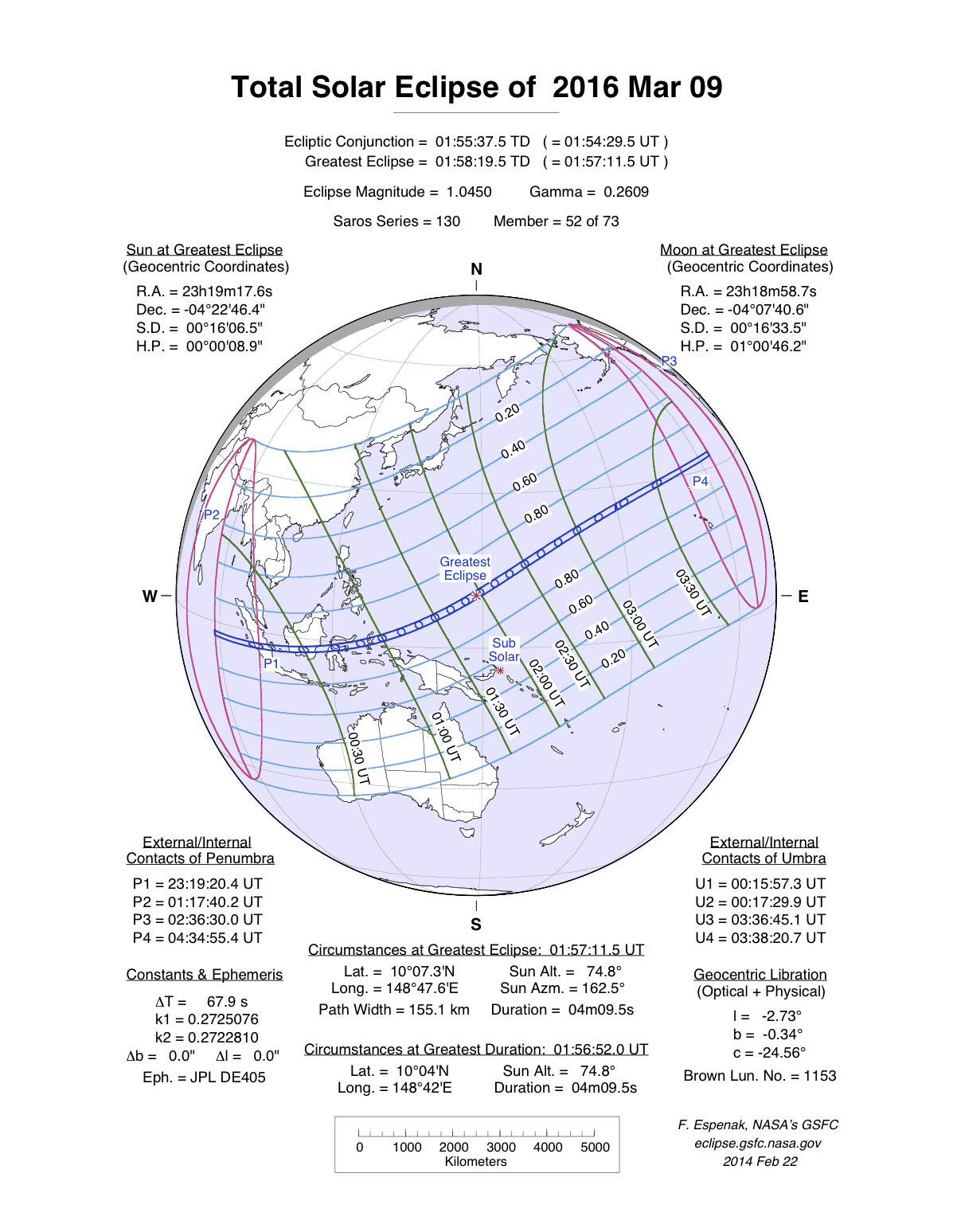
- A quick view of the faint solar atmosphere during the upcoming total
solar eclipse -- Scientists from NASA's Goddard Space Flight Center plan
on taking 59 several-second photographic exposures of the outer atmosphere of
the Sun from Indonesia using a special polarization camera in just over three
minutes during the upcoming total solar eclipse. The faint sections of the
Sun's atmosphere, including the inner solar corona, should become visible when
the Moon obscures the Sun for several minutes this week. [NASA
Goddard Space Flight Center]
The total solar eclipse should be visible
along a path extending from the eastern Indian Ocean across the Indonesia
(including Sumatra, Borneo and Sulawesi) and then eastward across the Pacific
Ocean to a point to the north of the Hawaiian Islands. A partial solar
eclipse would be seen by people in northern and western Australia, Oceania,
southeastern and eastern Asia (the Indochina Peninsula, eastern China and
Japan), Hawaii and southwestern Alaska. The eclipse will begin at 2319Z on 8
March 2016, reaching a maximum at 0159Z on 9 March 2016. Totality should last
for slightly more than four minutes. The NASA
Eclipse Web Site has more particulars and maps
of this solar eclipse.
- Satellite detects movement of Antarctic iceberg -- A pair of images
obtained from data collected by the MODIS (Moderate Resolution Imaging
Spectroradiometer) sensor onboard NASA's Aqua satellite documents the movement
of Iceberg B-09B that had blocked a bay in East Antarctica for more than five
years. One of the MODIS images was taken in February 2013, while the other
image was from several weeks ago. [NASA
Earth Observatory]
- Shifting winds during current El Niño monitored from space --
Scientists have been monitoring near surface wind data (both speed and
direction) over the Pacific Ocean collected by NASA's RapidScat scatterometer
instrument onboard the International Space Station (ISS) during the last year,
which is coincidental with the development of a major El Niño event that
appears to be peaking. Anomalous winds from the west have intensified during
the last year over the equatorial western Pacific with a weakening over the
eastern waters, which is typical of an El Niño event. Other changes in winds
across the northern sections of the basin can be attributed to the
teleconnections associated with this event. [NASA
Earth Observatory]
CLIMATE FORCING
- Last year's blowout from California well was largest US methane release
on record -- Researchers from NOAA, the University of California, Davis
and partners recently reported that during the peak of the Aliso Canyon
Natural Gas Storage Facility leak, enough methane gas escaped into the air
every day to fill a balloon the size of the Rose Bowl. Total emissions of this
greenhouse gas during the 112-day event that began in late October 2015 were
equal to one-quarter of the annual methane pollution from all other sources in
the Los Angeles Basin combined. Consequently, the disaster will substantially
impact California's ability to meet state greenhouse gas emission targets for
the year. [NOAA
News]
- Atmospheric river storms could reduce Sierra snowpack --
Researchers from NASA's Jet Propulsion Laboratory, Scripps Institution of
Oceanography and NOAA's Earth System Research Laboratory recently reported
that storms associated with the atmospheric river (AR) from off the
subtropical Pacific appear to be more than twice as likely to reduce the
snowpack in California's Sierra Nevada Mountains as other types of winter
storms that cause rain to fall on the snowpack. They based their conclusions
on analysis of NASA satellite and ground-based data from 1998 through 2014.
[NASA
Jet Propulsion Laboratory]
CLIMATE FORECASTS
- Canadian national seasonal outlook issued -- Forecasters with
Environment Canada issued their outlooks for temperature and precipitation
across Canada for meteorological spring, of the three months of March
through May 2016. Their temperature
outlook indicates that nearly all of Canada, with the exception of sections of
Labrador could experience above normal (1981-2010) temperatures for these
three months. A small area of in Atlantic Canada could see near average
spring temperatures.
The Canadian precipitation
outlook for Spring 2015 indicates that many areas scattered across
western, northern and eastern Canada could experience above near average
precipitation. A large section of Ontario could have below average
precipitation. Elsewhere, near average spring precipitation should occur.
[Note for comparisons and continuity with
the three-month seasonal outlooks of temperature
and precipitation
generated for the continental United States and Alaska by NOAA's Climate
Prediction Center, one would need to use Environment Canada's probabilistic
forecasts for temperature
and precipitation.]
PALEOCLIMATE
RECONSTRUCTION
- Recent eastern Mediterranean drought is worst in last nine centuries
-- Scientists who reconstructed the Mediterranean's long-term drought
history from tree rings report that the recent long-lived drought in the
eastern Mediterranean Levant region appears to be the worst of the past 900
years. The drought, which began in the Mediterranean Levant region consists
of Cyprus, Israel, Jordan, Lebanon, Palestine, Syria, and Turkey. In
addition, the team found that when the northern part of the Mediterranean,
consisting of Greece, Italy, and the coasts of France and Spain, were dry when
eastern North Africa was wet, and vice versa. These east-west and north-south
relationships helped the team understand what ocean and atmospheric conditions
lead to dry or wet periods, with the North Atlantic Oscillation and the East
Atlantic Pattern appearing to influence drought conditions across the
Mediterranean. A map of the region constructed from data collected from
NASA's Gravity Recovery and Climate Experiment, or GRACE, satellites shows a
decrease in water storage in the soil across northern sections of the
Mediterranean basin during the last several years. [NASA
Goddard Space Flight Center News]
CLIMATE AND SOCIETY
This Concept of the Week is repeated from Week 6.
Concept of the Week: Tropospheric westerly winds, north and south
The theoretical existence of upper tropospheric jet stream winds were not
confirmed until being encountered by World War II bomber pilots when heading
west into strong headwinds at altitudes of approximately 30,000 feet (10,000
m). Wind speeds sometimes exceeded 170 mph causing their relatively slow,
heavily laden aircraft to almost stand still. Subsequently, westerly jet stream
winds were found to encircle the planet in midlatitudes of both hemispheres
above regions of strong temperature contrasts.
The explanation for these winds involves atmospheric mass distributions and
forces on a rotating planet. Air in tropical latitudes is warmed, rises and
then flows poleward, both north and south. On a rotating planet, moving air is
deflected by the Coriolis effect, to the right in the Northern Hemisphere (and
left in the Southern). The greater the temperature differences between warm
lower and cold higher latitudes, the stronger the air motions and the faster
the jet streams. The vertical temperature patterns result in the highest wind
speeds near the top of the troposphere.
So Northern Hemisphere air headed northward, deflected to the right ends up
headed east, a "westerly wind." In the Southern Hemisphere, southward moving
air, deflected left will also go east, as a westerly wind. These "rivers" of
strong upper-level winds steer surface weather systems as they move generally
eastward across midlatitudes. They also provide boosts for jet aircraft headed
eastward with them, but need to be avoided for going west! Of course, the full
story is complex as land (especially mountains) and water surfaces interact
with the heating of the air and eddies form in the turbulent flows, so jet
streams wander. And with them go the storms and the weather patterns that form
our short-term climate.
Concept of the Week: Questions
(Place your responses on the Chapter Progress Response Form provided in the
Study Guide.)
- The Northern Hemisphere jet stream winds would be directed such that
cold air is [(to the left),(to the
right),(directly ahead)] of their forward
motion.
- In the Southern Hemisphere, the jet stream winds to be directed
generally toward the [(south), (east),
(west)].
Historical Events:
- 7 March 1932...A severe coastal storm set barometric pressure records
from Virginia to New England. Block Island, RI reported a barometric
pressure reading of 955.0 millibars (28.20 inches of mercury). (David
Ludlum)
- 7 March 1996...6.5 inches of snow fell at Boston, MA on this date to
bring its seasonal total to 96.4 inches -- the city's snowiest winter in
105 years of record keeping. The old record was 96.3 inches set in the
1993-94 winter season. Now all major cities along this East Coast had
broken their seasonal snowfall records in the 1995-96 winter season.
(Intellicast)
- 7 March 2000...The temperature at Duluth, MN reached 70 degrees, which
was the earliest that a 70-degree reading was reported in Duluth; the
previous earliest date was 22 March 1945 when the temperature reached 72
degrees. (Accord's Weather Guide Calendar)
- 7 March 1999...Moncton, New Brunswick, Canada's snowiest major city set
a new record for a one-day snowfall of 45.7 inches, but prior to that date
the winter's total had been a meager (for the city) 46 inches of snow. (The
Weather Doctor)
- 8 March 1971...A snowstorm dropped 10 to 20 inches of new snow across
Vermont to raise snow depths to record levels. A snow cover of 116 inches
was measured on the ground on top of Mount Mansfield, the second highest
snow depth ever recorded on the mountain up to the time. The town of Orange
measured 88 inches on the ground for a new state low-elevation snow depth
record. (Intellicast)
- 8 March 1992...In the first 8 days of March, Las Vegas, NV recorded
1.87 inches of rain, setting a new monthly record for rainfall in March.
The previous record was 1.83 inches set in 1973. (Intellicast)
- 8 March 1994...A major snowstorm buried sections of Oklahoma, Missouri,
and Arkansas. Ozark Beach, MO recorded 19 inches of snow, while Harrison,
AR checked in with 18 inches. Tulsa, OK had 12.9 of snow, for its greatest
single storm snowfall ever. (Intellicast)
- 8 March 1996...Elkins, WV received 2.1 inches of snow on this day to
bring its seasonal snowfall to 125.8 inches -- its snowiest winter on
record. (Intellicast)
- 9 March 1911...Aibonito, Puerto Rico had temperature of 40 degrees
Fahrenheit, the lowest temperature recorded on that island. (The Weather
Doctor)
- 9 March 1943...The temperature at Lac Frontiere, ME fell to 40 degrees
below zero, the lowest reading ever in March in New England. (Intellicast)
- 9 March 1956...A whopping 367 inches of snow was measured on the ground
at the Rainier Paradise Ranger Station in Washington. The snow depth was a
state record and the second highest total of record for the continental
U.S. (The Weather Channel)
- 10 March 1912...The barometric pressure reached 990.9 millibars (29.26
inches) at Los Angeles, CA, and 997.7 millibars (29.46 inches) at San
Diego, CA, setting all-time records for those two locations. (David Ludlum)
- 10 March 1922...Dodge City, KS reported an all-time record 24-hour
total of 17.5 inches of snow. (The Weather Channel)
- 10-11 March 1972, The temperature at Chicago, IL rose from 15 degrees
on the 10th to 73 degrees on the 11th. The 58-Fahrenheit degree temperature
rise tied the city's largest day-to-day rise on record. The city
experienced a similar jump in temperature in February 1887. (The Weather
Doctor)
- 11 March 1911...Tamarack, CA reported 451 inches of snow on the ground,
a record for the U.S. (David Ludlum)
- 11 March 1948...Record cold followed in the wake of a Kansas blizzard.
Lows of 25 degrees below zero at Oberlin, Healy, and Quinter established a
state record for the month of March. Lows of 15 degrees below zero at Dodge
City, 11 degrees below zero at Concordia, and 3 degrees below zero at
Wichita were records for March at these locations. The low of 3 degrees
below zero at Kansas City, MO was their latest subzero reading of record.
(The Weather Channel) (Intellicast)
- 11 March 2006...The record run for dry days in Phoenix, AZ finally
ended at 143 at 12:07 AM MST. The last measured rain in the city fell on 18
October 2005. The last time the region had significant precipitation was 2
August when 0.59 inch (15 mm) fell. Not only did the rain break the dry
spell, the 1.40-inch total was a record amount for the date: The previous
consecutive dry-day mark, set in 1998-99, was 101 days. (The Weather
Doctor)
- 12-13 March 1907...A storm produced a record 5.22 inches of rain in 24
hours at Cincinnati, OH. (The Weather Channel)
- 12 March 1923...The record low air pressure of 971.9 millibars (28.70
inches) for Chicago, IL was set during a storm that produced heavy snow, a
thick glaze, gales, and much rain that caused $800,000 damage.
(Intellicast)
- 13-15 March 1952...The world's 5-day rainfall record was set when a
tropical cyclone produced 151.73 inches of rain at Cilos, Reunion Island in
the Indian Ocean. The 73.62 inches that fell in a 24-hour period
(15th-16th) set the world's 24-hour rainfall record.
(Accord's Weather Guide Calendar)
- 13 March 1993...The "Great Blizzard of '93" clobbered the eastern US
and produced perhaps the largest swath of heavy snow ever recorded. Heavy
snow was driven to the Gulf Coast with 3 inches falling at Mobile, AL and
up to 5 inches reported in the Florida Panhandle, the greatest single
snowfall in the state's history. Thirteen inches blanketed Birmingham, AL
to set not only a new 24-hour snowfall record for any month, but also set a
record for maximum snow depth, maximum snow for a single storm, and maximum
snow for a single month. Tremendous snowfall amounts occurred in the
Appalachians. Mount Leconte in Tennessee recorded an incredible 60 inches.
Mount Mitchell in North Carolina was not far behind with 50 inches.
Practically every official weather station in West Virginia set a new
24-hour record snowfall. Farther to the north, Pittsburgh, PA measured 25
inches, Albany, NY checked in with 27 inches, and Syracuse, NY was buried
under 43 inches. The major population corridor from Washington, DC to
Boston, MA was not spared this time as all the big cities got about a foot
of snow before a changeover to rain. A rather large amount of thunderstorm
activity accompanied the heavy snow. Winds to hurricane force in gusts were
widespread. Boston recorded a gust to 81 mph, the highest wind gust at
that location since hurricane Edna in 1954. Numerous cities in the south
and mid Atlantic states recorded their lowest barometric pressure ever as
the storm bottomed out at 960 millibars (28.35 inches of mercury) over
Chesapeake Bay. Some 208 people were killed by the storm and total damage
was estimated at $6 billion-- the costliest extratropical storm in history.
(Intellicast)
Return to DataStreme ECS
RealTime Climate Portal
Prepared by Edward J. Hopkins, Ph.D., email hopkins@aos.wisc.edu
© Copyright, 2016, The American Meteorological
Society.