WEEKLY CLIMATE NEWS
PREVIEW WEEK: 23-27 January 2017
ITEMS
OF INTEREST
- Welcome climate science educators to the annual AMS meeting -- The 97th annual meeting of the American Meteorological Society (AMS) is being held this week (22 - 26 January) in Seattle, WA. The theme for this year's AMS meeting is "Observations Lead the Way," stressing the need for observations to obtain the information needed by meteorologists and those in allied disciplines. One of the numerous symposia and conferences that will be conducted at the meeting is the 26th Symposium on Education, where educators from kindergarten through university levels will be attending workshops or giving presentations on weather, ocean, climate and space science education issues.
- Worldwide GLOBE at Night 2017 Campaign is underway -- The first in the series of GLOBE at Night citizen-science campaigns for 2017 will continue through Saturday, 28 January. GLOBE at Night is a worldwide, hands-on science and education program designed to encourage citizen-scientists worldwide to record the brightness of their night sky by matching the appearance of a constellation (Orion in both the Northern and Southern Hemispheres) with the seven magnitude/star charts of progressively fainter stars.
Activity guides are also available. The GLOBE at night program is intended to raise public awareness of the impact of light pollution.
The next series in the 2017 campaign is scheduled for 18-27 February 2017. [GLOBE at Night]
- Quantifying this winter's severity across the nation -- At the midpoint of the meteorological winter season (December, January and February), the Midwestern Regional Climate Center (MRCC) has been calculating and posting the Accumulated Winter Season Severity Index (AWSSI) for approximate 100
stations around the 48 contiguous United States and Alaska. The AWSSI was developed by a former
director of MRCC and a weather
forecaster at the National Weather Service Forecast Office in Omaha, NE as an objective index that uses commonly available weather data to
quantify and describe the relative severity of the winter season. Click on the stations displayed on the map to reveal the daily sequence of AWSSI values through the current date. [MRCC]
- Accessing and interpreting climate data -- If you would like to obtain a variety of climate data for your home
town or state that are available from the National Weather Service,
please read this week's Supplemental
Information...In Greater Depth. This Supplemental not only
identifies some of the sites to find the data, but also provides you
with a brief explanation of the terminology used to identify the
climate data.
CURRENT
CLIMATE STATUS
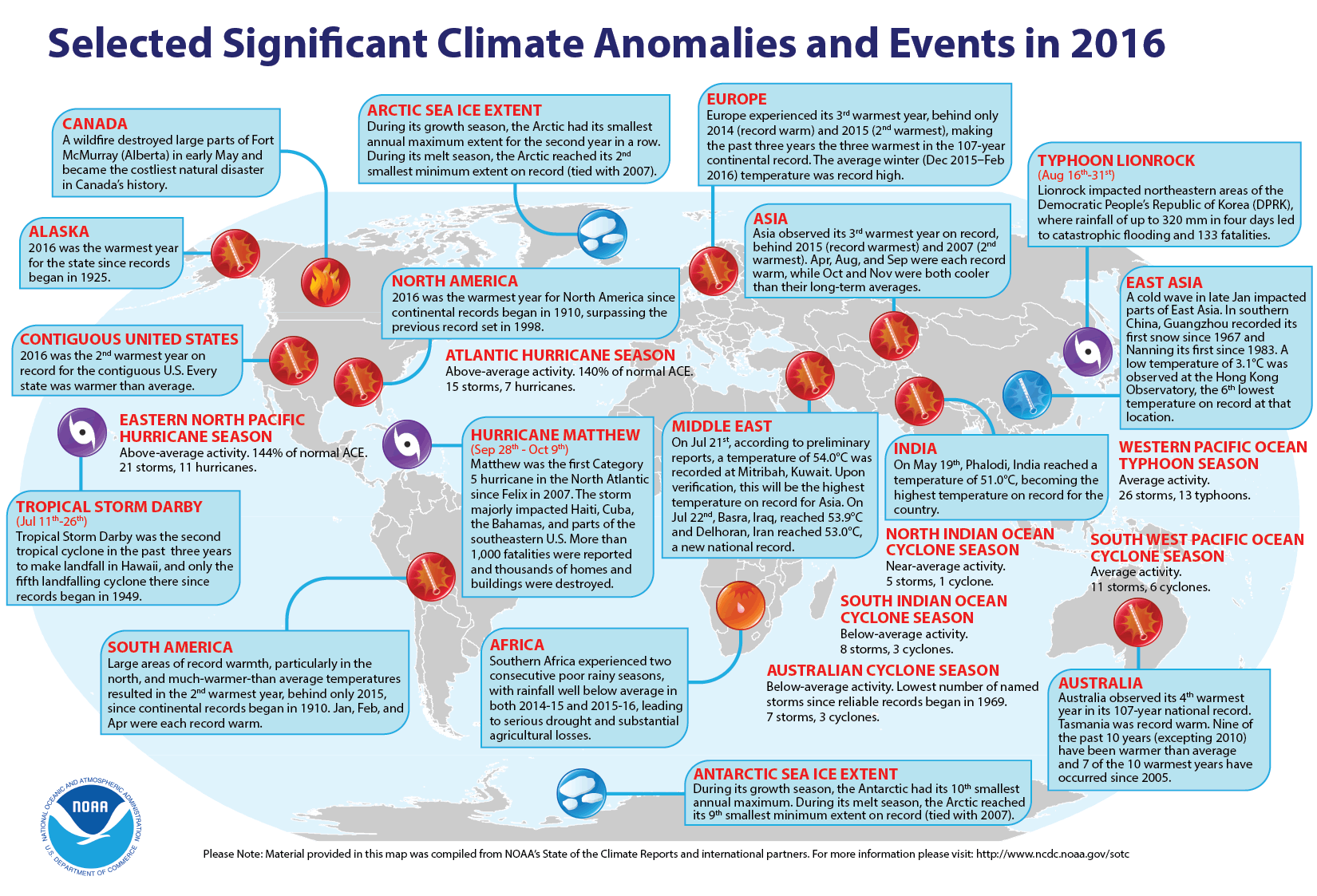
- Global weather and climate for 2016 reviewed -- Scientists at NOAA's National Centers for Environmental Information (NCEI) reported that
based upon their preliminary analysis of worldwide land and ocean
surface temperature data, the calendar year of 2016 was the warmest since sufficiently detailed world-wide climate records began in 1880. The average global temperature across land and ocean surface areas for 2016 was 1.69 Fahrenheit degrees above the 20th century (1901-2000) average of 57.0 degrees Fahrenheit, exceeding the previous record temperature departure set in 2015 by 0.07 Fahrenheit degrees. The scientists attributed the record global temperature to record warm oceans. When considered separately, annually-averaged temperature for ocean surfaces in 2016 was 1.35 Fahrenheit degrees higher than the 20th century average, which set a record high departure.
A near-record strong El Niño event (an anomalous
atmospheric and oceanic circulation regime favoring warm or cool waters in the
equatorial Eastern Pacific Ocean) commencing in late 2015 and continuing into 2016 contributed to the record warmth of the near-surface waters of the global oceans. The global land surface temperature for 2016 was 2.57 Fahrenheit degrees above the 20th century average,
which surpassed the previous annual land record set in 2015.
The
Arctic sea ice remained well below the long-term averages that cover the period of record beginning in 1979 when satellite surveillance of the polar ice caps began. During the winter growth season, the sea ice covering the Arctic experienced its smallest annual maximum extent, while at the end of the summer melt season, the sea ice tied 2007 for the second smallest minimum summer extent on record. Sea ice extent around Antarctica also was below average. During the winter growth season, the ice around that content reached the tenth smallest annual maximum extent for the satellite period, while during the summer melt season, the ice extent was the ninth smallest minimum on record.
The scientists also note that the preliminary global precipitation data
from land-based stations indicate 2016 a complex pattern, with many areas experiencing extreme drought because of below to much below average precipitation, while other land areas of the planet were exceptionally wet. [NOAA/NCEI
State of the Climate]
NCEI also provides a map showing the Global Significant Weather and Climate Events map for 2016.
Using data from essentially the same number of stations, but a slightly different methodology for averaging global surface
temperatures, scientists at NASA's Goddard Institute for Space Studies
(GISS) reported that the global average temperature for 2016 also was the
highest reading since 1880. [NASA
GISS] In a joint news conference held last Wednesday, the director of NASA GISS and the Chief of the Monitoring Branch of NCEI announced their findings that are summarized in graphical format on 14 slides. [NOAA/NASA Press Briefing]
A 15-second animated loop of global temperature anomaly maps showing the spatial distribution of the differences between observed and 20th century average temperatures was generated for each year from 1880 through 2016. An animation is also available in mp4 format. [NOAA Climate.gov News]
A blog was written
by a contractor for NCEI examining the statistical likelihood of the occurrence of a record high global temperature in three consecutive years or from 2014 through 2016.
[NOAA Climate.gov News]
NCEI also produced a summary of the global weather and climate for December 2016.
The December 2016 globally-averaged temperature across both land and ocean surfaces was 1.42 Fahrenheit degrees above the 20th century average, which represents the third highest temperature departure for the month since 1880, falling behind the December 2015 and December 2014 readings. The December 2016 surface temperature averaged across the global oceans was the fourth highest global ocean temperature on record, while the monthly temperature for the land surface ranked as the sixth highest December global land temperature. [NOAA/NCEI
State of the Climate]
CURRENT
CLIMATE MONITORING
- Satellite sees ash cloud develop over Alaskan volcano -- An image produced from data collected last week by the Moderate Resolution Imaging Spectroradiometer (MODIS) onboard NASA's Terra satellite reveals a plume of ash and condensate emanating from a partially submerged volcano on Bogoslof Island in Alaska's Aleutian Island chain. Some of the volcanic material was reported to have reached nearly 35,000 feet (10 km). [NASA Earth Observatory]
- Jason-3 satellite celebrates one year anniversary -- One year ago last week, the Jason-3 (for the third Joint Altimetry Satellite Oceanography Network) satellite was successfully launched into a low Earth orbit with an altitude of approximately 830 miles above the Earth's surface. Jason-3 satellite joins its predecessor Jason-2 in continuing to make ocean surface height measurements using onboard radar altimeters, which were first made from space by the TOPEX/Poseidon mission in 1992. In addition to monitoring sea surface height over time for assessing climate change, Jason-3 collects data on wave height and ocean winds. [NOAA NESDIS News]
CLIMATE
FORCING
- Higher global temperatures could cause temporary increase in lake effect snows along Great Lakes -- A meteorologist with the National Oceanic and Atmospheric Administration (NOAA) Climate Prediction Center wrote feature article for the NOAA ClimateWatch Magazine explaining the apparent paradox that exists concerning an increase in lake effect snowfall along the downwind sides of the Great Lakes over recent decades even though global air temperatures have been increasing. Maps and satellite images showing the regions where lake effect snow are provided. [NOAA News]
CLIMATE
FORECASTS
- Global mild weather days pattern is shifting in response to changing climate -- Scientists from NOAA's Geophysical Fluid Dynamics Laboratory (GFDL) and Princeton University have made a global analysis of the frequency and location of the number of days considered to contain "mild weather," or weather conditions favorable to humans and to a variety of business. The mild weather days were defined as those having air temperatures that range between 64 and 86 degrees Fahrenheit, have less than one half inch of rain and have dew point temperatures (a measure of atmospheric water vapor content) below 68 degrees F, indicative of low humidity. According to this definition, the current global average is 74 mild days per year. Using high-resolution climate models, the researchers predict that by the end of the century, the global average of mild weather days will drop by 10 per year, or by 13 percent, due to increased global temperatures associated with fossil fuel burning by humans. The largest decreases in mild weather were expected to occur in tropical regions because of rising temperatures and humidity, with Africa, Asia and Latin America being hardest hit. However, some mid-latitude locations, especially parts of the US, Canada, northern Europe could gain a few more milder days. [NOAA News]
CLIMATE
AND THE BIOSPHERE
- Higher water temperatures along West Coast increases risk of toxic shellfish -- Scientists from Oregon State University, the Oregon Department of Fish and Wildlife and NOAA National Marine Fisheries Service have discovered a high correlation between higher water temperatures offshore of Oregon and Washington and high levels of domoic acid, a shellfish toxin, in shellfish collected from these waters. The higher ocean temperatures are attributed to climate change. The research team has also produced a climate-based model, which predicts the time and location of domoic acid levels in Oregon and Washington shellfish that could exceed public safety limits. [NOAA NCCOS News]
- Patterns of tree mortality seen during extreme drought -- A team of researchers from the University of California Davis and the US Department of Agriculture's Forest Service have found that their aerial surveys of tree mortality show patterns of tree death during periods of extreme drought as ascertained from climate data. The aerial tree mortality surveys were conducted by between 2012 and 2015) during an extreme drought in California. The researchers found that trees in the driest, densest forests are most vulnerable to dying in extreme drought; the effects of extreme drought on forests can take years to surface; and high tree mortality rates are likely to continue as drought effects linger. [University of California Davis News]
CLIMATE
AND HUMAN HEALTH
- Geographic distribution of Lyme disease across nation appears related to temperature and humidity -- A US Geological Survey (USGS) research ecologist and colleagues at the University of Rhode Island and Michigan State University claim that the reason why Lyme disease is more prevalent in the Northeast, Mid-Atlantic and Upper Midwest, but less common crossways the South is associated with air temperature and humidity. The temperature and humidity appear to affect the behavior of disease-bearing ticks. The researchers studied the metabolism, life cycle and behavior of black-legged ticks, finding tick larvae live longer in relatively cool "northern" conditions. The northern ticks can be found on leaves and twigs above the leaf litter surface closer to human contact, while southern ticks remain below the litter surface farther away from humans. [USGS Newsroom]
CLIMATE
AND SOCIETY
Concept of the Week: Touring the DataStreme Earth's
Climate System RealTime Climate Portal Website
Welcome to DataStreme Earth's Climate System (ECS)! The AMS Climate Studies RealTime Climate Portal is an integral component of the DataStreme ECS (Earth's Climate System) course. The website is intended to deliver a wealth of climate information that is both pertinent to the course as well as being a reference site for you as you study Earth's climate system. The webpage is arranged in several sections. On Monday of each week of the course, we will post the current Weekly Climate News that includes Climate in the News (a summary listing of recent events related to climate), Concept of the Week (an in-depth analysis of some topic related to climate in the Earth system), and Historical Events (a list of past events important in the understanding of climatology). When appropriate, Supplemental Information...In Greater Depth will be provided on some topic related to the principal theme of the week.
You will use the RealTime Climate Portal to access and download the "Current Climate Studies" that complement your Climate Studies Investigations Manual. These materials should also be available Monday morning. Click the appropriate links to download and print these electronic components of the investigations as well as your Chapter, Investigations and Current Climate Studies Response forms.
Beyond these course Learning Files, sections include Climate
Information, Climate Variability, Climate
Change, Societal Interactions and Climate Policy, and Extras. As the titles suggest, there are
multiple uses for climate data and their interpretation. Here we
explore some examples of the information provided in the various
sections of the RealTime Climate Portal.
The Climate Information section includes
access to weather data, the raw material of climate synthesis, from the
United States and the world under the heading "Observations and Data."
Under this heading, click on "U.S. and World Weather Data." This
National Oceanic and Atmospheric Administration (NOAA) page first
directs you to "United States Weather" and provides channels to current
weather data as well as radar graphics, weather maps, and aviation and
marine weather. It then leads you to International Weather
Conditions.
The second major subdivision of the RealTime Climate Portal encompasses Climate Variability. Climatic variability refers to
the fluctuations and oscillations that may occur within the climate
system at temporal and spatial scales beyond that of individual weather
events. Select the link, "NOAA El Niño Page". The page that appears
provides access to a wealth of background and information on El Niño
and La Niña, including the animation showing sea surface temperatures
(SST) in the tropical Pacific during recent months. To the left of the
animation, click on "What's happening today?" The page of current
tropical Pacific conditions that appears shows a small map to the
right. Click on that map and again anywhere on the subsequent set of
map panels to get an enlarged view of the latest conditions of SST and
anomalies.
The third major section of the RealTime Climate Portal is termed Climate
Change. Here we provide links to information and analyses
that primarily focus on anthropogenic (human-made) change processes and
results in the climate system. That prominently includes the
Intergovernmental Panel on Climate Change's ("IPCC") latest classic
report on atmospheric greenhouse gas emissions and their effects. Also
linked are modeling results ("Models") based on those studies.
The last major section of the RealTime Climate Portal is titled Societal
Interactions and Climate Policy. This block contains
information on the impacts of projected change on human societies
around the world, beyond that listed in the IPCC report, and the
international actions and debates regarding those issues. Select and
click on "National Climate Assessment (NCA3) Highlights" in this section.
This webpage introduces you to the latest comprehensive and
authoritative report on climate change and its impacts in the United
States, now and in the future. You will be directed to this report
several times in this course.
Completing the RealTime Climate Portal is the Extras section of additional handy information for the course and individual
study such as dictionaries of terms, maps and materials. Choose and
examine one of the Climate Literacy links. This document has recently been developed and
released by NOAA to provide an overview of general concepts and
information the general public and especially students should be aware
of regarding the climate and the climate debate.
Concept of the
Week: Questions
- The first Climate Information link,
"NOAA's Climate.gov", shows the Global Climate Dashboard where
several graphs display Earth's temperature, atmospheric carbon dioxide
level, spring snow cover, etc. with a time slider than can be set to
display from [(1800)(1880)(1940)] to the latest data in 2016.
- Under the Societal Interactions and Climate Policy section, click the "Global Resilience Toolkit" link. The Toolkit has been designed to aid in working through climate change issues by communities. As the first step to building resilience, one should [(Prioritize actions)(Explore climate threats)].
Historical Events:
- 23-24 January 1916...The temperature at Browning, MT plunged
100 Fahrenheit degrees in just 24 hours, from a relatively mild 44 degrees above zero to a bone-chilling 56 degrees below zero.
This 24-hour temperature drop is a US record. (National Weather Service files)
- 24 January 1857...The coldest weather in pre-U.S. Weather
Bureau history occurred with temperatures of 50 degrees below zero
reported in Maine, New Hampshire, and Vermont. The temperature was 30
degrees below zero in Boston, MA and 11 degrees below zero on Nantucket
Island. (Intellicast)
- 24 January 1922...The all-time record low temperature for
the state of Wisconsin was set at Danbury when the temperature dipped
to 54 degrees below zero. (This record has been broken by
one degree in February, 1996) (National Climate Data Center)
- 24 January 1956...Thirty-eight inches of rain deluged the
Kilauea Sugar Plantation of Hawaii in 24 hours, including twelve inches
in just one hour. The 38.00 inches remains the Aloha State's 24-hour
maximum precipitation record. (David Ludlum)
- 25 January 1821...People were able to walk across the frozen Hudson River between Hoboken and New York City. Entrepreneurs sold coffee on the river to warm pedestrians. (National Weather Service files)
- 25-26 January 1956...The U.S. record for rainfall in one hour was set at Kilauea, HI, with exactly one foot of rain (this tied the record set at Holt, MO on 22 June 1947). The observer noted, however, that his gauge overflowed several times during the heavy rain (which continued into the following day) and the true total amount may have been even higher. (National Weather Service files)
- 25 January 1965...Alta, UT was in the midst of a storm that
left the town buried under 105 inches of snow establishing a record for
the state. (David Ludlum)
- 26 January 1884...The coldest day on Canada's Prince Edward
Island occurred when the temperature at Kilmahumaig, PEI fell to 35
degrees below zero. (The Weather Doctor)
- 27 January 1940...Florida had a 3-day long freeze with the
lowest temperatures ever in January. Mason, FL dropped to 8 degrees.
Eleven million boxes of citrus were damaged, resulting in a 10
million-dollar loss. Further north, Georgia's record low temperature of
17 degrees below zero was set near Calhoun. (Intellicast)
- 27 January 1994...A frigid arctic air was in place over New
England and New York as a massive 1052-millibar (31.06 inches of
mercury) high pressure provided ideal radiational cooling. Crown Point,
NY dipped to 48 degrees below zero and Shoreham, VT shivered with 46
degrees below zero, Burlington, VT broke its old record daily low by 9
degrees with a reading of 29 degrees below zero and Caribou, ME set a
record low for the third day in a row with a temperature of 23 degrees
below zero. (Intellicast)
- 28 January 1925...The temperature at Pittsburg, NH fell to
46 degrees below zero, establishing a new record low temperature for
the state. (Intellicast) In January 1934, this record was broken with a
reading of 47 degrees below zero. (NCDC)
- 28 January 1963...The low temperature of 34 degrees below
zero at Cynthiana, KY equaled the state record established just four
days earlier at Bonnieville. (The Weather Channel) This all-time state
record for Kentucky has since been eclipsed by a 37 degree zero reading
in January 1994. (NCDC)
- 28 January 1988...Barometric pressure readings of 30.55
inches at Miami FL, 30.66 inches at Tampa, FL, and 30.72 inches at
Apalachicola, FL were all-time record high readings for those
locations. (National Weather Summary)
- 28 January 1989...Nome, AK reported an all-time record low
reading of 54 degrees below zero. (National Weather Summary)
- 29 January 1934...The temperature at the Observatory on top
of Mt. Washington, NH (the highest point in New England) fell to 47
degrees below zero, establishing a new all-time record low temperature
for the state. (NCDC)
Return to RealTime Climate Portal
Prepared by Edward J. Hopkins, Ph.D., email hopkins@aos.wisc.edu
© Copyright, 2017, The American Meteorological Society.