WEEKLY CLIMATE NEWS
27-31 March 2017
ITEMS
OF INTEREST
- Worldwide GLOBE at Night 2017 Campaign is underway -- The third in the series of GLOBE at Night citizen-science campaigns for 2017 will continue through Wednesday, 29 March. GLOBE at Night is a worldwide, hands-on science and education program designed to encourage citizen-scientists worldwide to record the brightness of their night sky by matching the appearance of a constellation (Leo in the Northern Hemisphere and Canis Major in the Southern Hemisphere) with the seven magnitude/star charts of progressively fainter stars.
Activity guides are also available. The GLOBE at night program is intended to raise public awareness of the impact of light pollution.
The next series in the 2017 campaign is scheduled for 18-27 April 2017. [GLOBE at Night]
- Accessing the national climatographies -- NOAA's
National Climatic Data Center (NCDC) has produced numerous
climatographies that are quantitative descriptions of climate that
include tables and charts portraying the characteristic values of
selected climatic elements at a station or over an area. Some of these
climatographies provide a variety of daily, monthly and annual normal
climate data for agricultural, transportation and other interests. This
week's Supplemental Information...In
Greater Depth provides the links to selected climatographies
from NCDC.
CURRENT
CLIMATE STATUS
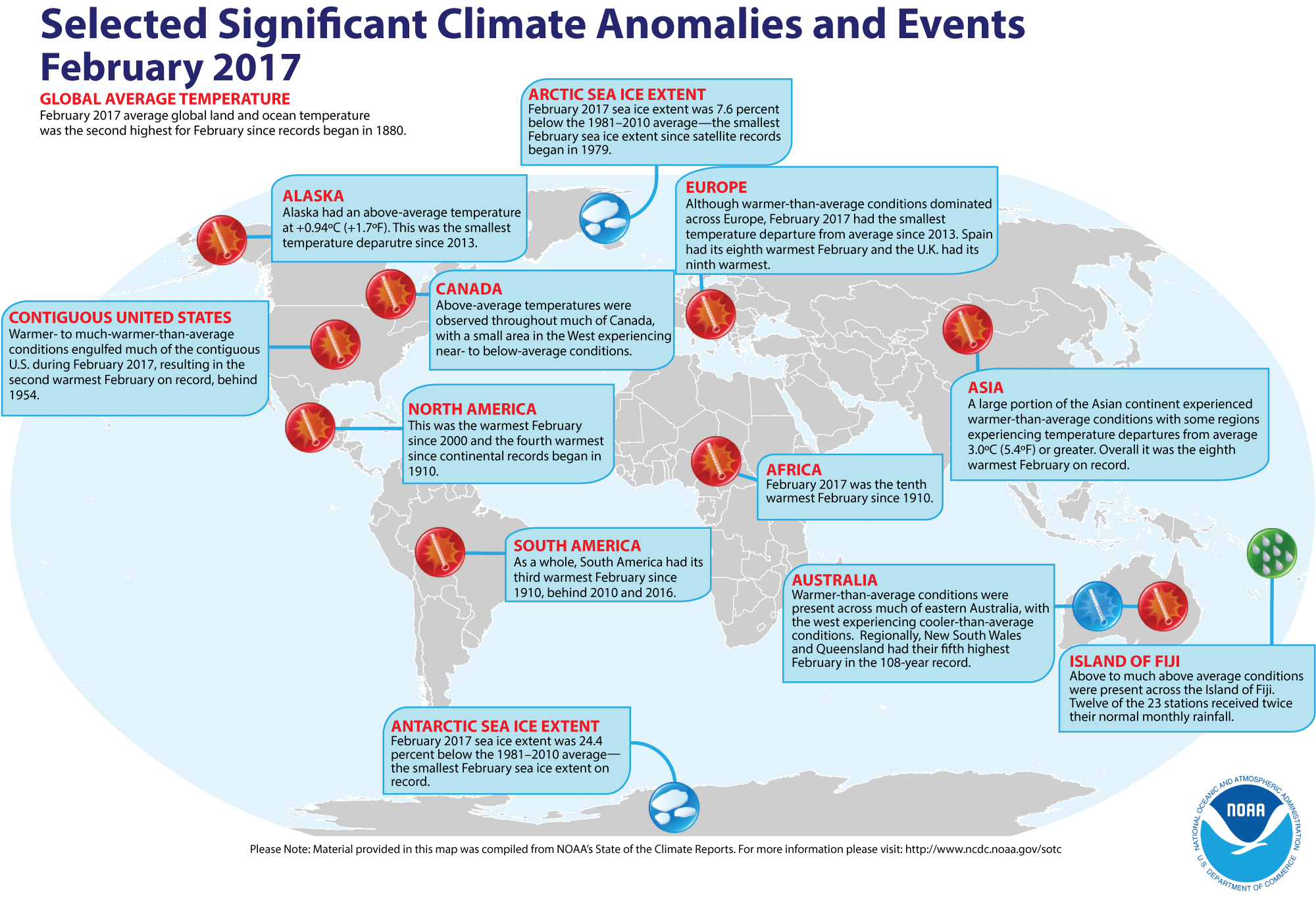
- Review of global weather
and climate for February 2017 -- Using preliminary data
collected from the global network of
surface weather stations, scientists at NOAA's National Centers for Environmental Information (NCEI) have determined that the combined global land and ocean surface
temperature for February 2017 was 0.98 Celsius degrees above the 20th century (1901-2000) average, which represents the second highest global average February temperature since comprehensive global climate records began in 1880. This February temperature departure ranks behind the record February temperature departure of 1.20 Celsius degrees above average set one year ago in February 2016. Individually, the global ocean surface temperature for this past month was the second highest in the 138-year period of record, as was the average global
land surface temperature for February 2016.
Furthermore, the three-months running from December 2016 through February 2017 that constitute meteorological winter in the Northern Hemisphere (and meteorological summer in the Southern Hemisphere) had the second highest three-month average combined global temperature for any such interval since 1880/81.
[State of the
Climate/NCEI]
NCEI also provides a map showing the Global Significant Weather and Climate Events map for February 2017.
According to the National Snow and Ice Data Center, the extent of both the
Arctic sea ice and Antarctic sea ice for February were the smallest monthly extents for any February in the two basins since satellite surveillance began in 1979. Furthermore, the Arctic sea ice extent appeared to have reached its annual maximum extent near the end of the first week of March, slightly ahead of the occurrence of typical peak winter extent in mid-March. The 14.42-million square km size would represent the lowest maximum seasonal extent in the 38-year satellite-era.[ National Snow and Ice Data Center] At the same time, the Antarctic summer minimum extent also reached a new record low. [NOAA Climate.gov News]
The extent of the Northern Hemisphere snow cover during February 2017
was
the 22nd largest for the period of record that
started in 1967. In addition, the snow cover in the Northern Hemisphere for the winter season (December 2016-February 2017) was the tenth largest on record. [NOAA/NCEI Global Snow & Ice]
- Long-term trends revealed in Arctic and Antarctic sea ice extent -- Graphs of the monthly variations in the extent of sea ice extent in both the Arctic basin and around Antarctica since 1979 when satellite surveillance began have been plotted and compared by scientists at NASA and the National Snow and Ice Data Center. A graph of the combined Arctic and Antarctic sea ice departures is provided. The time series on these graphs, which are plotted as deviations in sea ice extent, show a general decrease in Arctic sea ice extent since 1979, while a modest increase in sea ice around Antarctica until a major decrease in ice extent during the last two years. [NASA Earth Observatory]
- Explaining the wavy nature of the sea ice extent near annual maximum winter extent -- A staff member at the National Snow and Ice Data Center wrote a feature that explains why plots of sea ice extent become wavy near the time of the maximum winter ice extent in the Arctic during March and in September for maximum ice extent surrounding Antarctica. [NOAA Climate.gov News]
CURRENT
CLIMATE MONITORING
- Farewell to a pathfinder Earth satellite -- On this Thursday (30 March 2017) NASA will decommission its Earth Observing-1 (EO-1) satellite as it will be powered off after 17 years in orbit. EO-1, a part of NASA's New Millennium Program, was placed in a sun-synchronous orbit in November 2000 as a means for developing and validating several instrument and spacecraft technologies. The Advanced Land Imager (ALI) on board EO-1 provided a variety of Earth data including observations of forest cover, crops, coastal waters and aerosols. The hyper-spectral instrument called Hyperion permitted scientists to see chemical constituents of Earth's surface in fine detail with hundreds of wavelengths, leading to the identification of specific minerals, the tracking of vegetation type and vigor of forests and monitor volcanic activity. [NASA Goddard Space Flight Center Feature]
- Global ammonia "hot spots" identified by satellite surveillance -- A scientists from the University of Maryland and NASA's Jet Propulsion Laboratory using data collected by the Atmospheric Infrared Sounder (AIRS) instrument on NASA's Aqua satellite were able to track trends in global atmospheric ammonia concentration between 2002 and 2016. Maps were produced showing the locations of "hot spots" of the pollutant over four of the world's most productive agricultural regions (in the United States, Europe, China and India), where rapid increases in ammonia were detected due to a combination of increased fertilizer application, reduced scavenging by acid aerosols and climate warming. Decreases in ammonia were detected due to reduced agricultural burning or fewer wildfires. Increased atmospheric ammonia concentrations are linked to decreased air and water quality. The data could help in development of strategies to control pollution from ammonia and ammonia by products in Earth's agricultural areas. [NASA Global Climate Change News]
CLIMATE
FORCING
- Orbiting solar observatory sees spotless Sun for two-week stretch -- Instruments onboard NASA's Solar Dynamics Observatory (SDO) observed a spotless Sun over a 15-day stretch beginning on 7 March 2017, representing the longest stretch of a spotless Sun since April 2010 during the last solar minimum. SDO is in a geosynchronous orbit of Earth with an orbital height of 22,369 mi. Images made by SDO on 20 March 2017 during this spotless interval are compared with those with numerous spots on the solar disk on 27 February 2014 during the last solar maximum. [NASA Goddard Space Flight Center Feature]
CLIMATE
FORECASTS
- Assessing the performance of the 2016-17 Winter Outlook -- A contractor for NOAA's Climate Prediction Center (CPC) recently wrote a feature for the ENSO Blog in which he assesses the performance of CPC's Winter Outlook for the three winter months of December 2016 through February 2017 that was made in November 2016. Asking the question "How well did we do?" he compared the temperature and precipitation outlooks against the observed temperature and precipitation patterns across the contiguous US for these three winter months. A La Niña winter had been anticipated. He notes that a large section of the nation did have above average temperatures as forecast, but the region of below average temperatures were found farther to the west than anticipated. The precipitation outlook did not perform as well. [NOAA Climate.gov News]
CLIMATE
AND THE BIOSPHERE
- Wildfires burn across southern and central Plains in late winter -- A warm and dry winter across the Plains running from Texas northward to Kansas along with strong near surface winds created conditions ripe for widespread prairie fires so far in March 2017. Thousands of cattle perished because of these wildfires; in addition seven people were killed by the fires in Texas. Fires in Kansas consumed more than 400,000 acres, the largest in state history.
[NOAA News]
- Monitoring stress on Great Barrier Reef from space -- A map was produced by NOAA's Coral Reef Watch showing various levels of heat stress in the waters to the east of Australia during the last week of February 2017 that are indicators of coral bleaching and its potential intensity in the Great Barrier Reef. Data for this stress level map were obtained from measurements of sea surface temperature made by several satellites, including the NOAA-NASA Suomi NPP satellite, the European Space Agency's Meteosat and the Japanese MTSAT. [NASA Earth Observatory]
- Effects of weather variability and market dynamics on maple syrup production -- A researcher at Montana State University and her colleagues recently showed climate change may be having an effect on the maple syrup industry across the United States and Canada. Higher temperatures are leading to earlier dates for tapping trees and may be contributing to the quantity and quality of sap harvested as well. Early research suggests that the higher quality light colored sap may show up in less abundance as a result of warmer weather, which favor the darker quality sap. [Montana State University News]
PALEOCLIMATE
RECONSTRUCTION
- Ancient sediments under Dead Sea provide warnings of a dire future drought -- Scientists from Columbia University's Lamont-Doherty Earth Observatory, Israel and Spain have discovered thick layers of crystalline salt nearly 1000 feet below the bed of the Dead Sea that provide evidence of major drought in the Mideast during warm periods. The deposits were found as part of the International Continental Scientific Drilling Program (ICDP) Dead Sea Deep Drilling Project. The researchers warn that with projected warming in the future, a major drought could develop. [Lamont-Doherty Earth Observatory News]
CLIMATE
AND SOCIETY
Concept of the Week: Feedback in Earth's
Climate System
In Earth's climate system, feedback consists of a
process where a change in one variable interacts with other variables
of the system to alter that original variable. If the change reinforces
the original quantity, it is known as a positive feedback.
If the change suppresses the original quantity, it is a negative
feedback. Feedbacks in Earth's climate system are
significant--thought to be responsible for more than half the global
warming expected from human activities.
Consider examples of positive and negative feedback. A warming
trend in climate is likely to accelerate the rate of melting of snow
and ice, producing more bare ground that absorbs more solar radiation,
further raising the air temperature. A cooling trend prolongs snow and
ice cover in spring and summer so that less solar radiation is
absorbed, more reflected to space, bringing about additional cooling.
In both cases, feedback is positive because the initial change in
temperature is amplified.
Consider an example of negative feedback. While feedbacks
among temperature, cloud cover, and radiation are not well understood
and depend upon circumstances (e.g., type and height of clouds), they
could be either positive or negative. It is thought that a warming
trend in climate should increase the rate of evaporation of water from
Earth's surface and thereby increase low cloud cover. A thicker and
more extensive low-cloud cover reflects more solar radiation to space
thereby inhibiting a further rise in surface temperature. Hence, this
negative feedback would dampen the initial temperature change.
Understanding feedback in the climate system is essential for
modeling and predicting climate change. If some agent or mechanism
alters the climate, then feedback may either amplify (positive
feedback) or dampen (negative feedback)
the change in climate. As demonstrated later in this course, many
agents and mechanisms can bring about climate change (e.g., variations
in solar energy output, regular fluctuations in Earth-Sun geometry).
While these climate forcing agents and mechanisms drive climatic
change, processes within the planetary climate system involving
feedbacks significantly impact the magnitude of climate change.
Overall, which type of feedback prevails in Earth's climate
system, positive or negative? A system in which positive feedback
prevails is unstable. For Earth, this would move the climate regime
toward an extreme characterized by excessive cold that would encase the
planet in snow and ice ("snowball" or "ice ball" Earth) or toward the
other extreme resulting in much higher temperatures--the product of a
runaway greenhouse effect. Although Earth's climate has varied
considerably over the billions of years that constitute geologic time,
it appears likely that Earth's climate system has been nearly stable
with negative feedbacks generally compensating for positive feedbacks.
Concept of the Week: Questions
Place your responses on the Chapter Progress Response Form
provided in the Study Guide.
- The magnitude of a climate change [(largely
depends upon)(is independent of)] positive and negative feedback phenomena operating in
Earth's climate system.
- Through much of Earth history, it appears that [(positive
feedbacks)(negative feedbacks)(a
general balance between positive and negative feedbacks)] have (has) prevailed.
Historical Events:
- 27 March 1931...A blizzard that struck western Kansas and
adjoining states was called the "worst since January 1888". The low
temperature of 3 degrees below zero, which was reached during the
blizzard, stands as the lowest temperature recorded so late in the
season. (Intellicast)
- 27-28 March 1964...The most powerful earthquake in US
history, the Good Friday Earthquake, rocked south central Alaska,
killing 125 people and causing $311 million in property damage,
especially to the city of Anchorage. The earthquake in Prince William
Sound, which had a magnitude of 9.2 on the Richter scale, caused some
landmasses to be thrust upward locally as much as 80 feet, while
elsewhere land sank as much as 8 feet. This earthquake and submarine
landslides also created a tsunami that produced extensive coastal
damage. A landslide at Valdez Inlet in Alaska generated a tsunami that
reached a height of 220 feet in the inlet. A major surge wave that was
approximately 100 ft above low tide caused major damage to Whittier
(where 13 died) and other coastal communities in Alaska. The first wave
took more than 5 hours to reach the Hawaiian Islands where a 10-foot
wave was detected, while a wave that was 14.8 feet above high tide
level traveled along portions of the West Coast, reaching northern
California 4 hours after the earthquake. Nearly 10,000 people jammed
beaches at San Francisco to view the possible tsunami, but no
high-amplitude waves hit those beaches. Tsunami damage reached Crescent
City in northern California. Tens of thousands of aftershocks indicated
that the region of faulting extended about 600 miles. The Alaska
Tsunami Warning Center was established in the wake of this disaster,
with a mission to warn Alaskan communities of the threat from tsunamis.
(Accord's Weather Guide Calendar) (US Coast Guard
Historians Office)
- 27 March 1984...A strong storm system traversing northern
Texas pulled very hot air northeastward into southern Texas. The
temperature at Brownsville, TX soared to 106 degrees, which broke not
only the monthly record high temperature but the all-time record as
well. Cotulla, TX reached 108 degrees, equaling the March record for
the U.S. (The Weather Channel) (Intellicast)
- 27-28 March 2009...A blizzard moving across the southern
Plains was responsible for new 24-hour snowfall records for the states
of Kansas, Oklahoma and Texas. A 30.0-inch snowfall at Pratt eclipsed
the previous Kansas 24-hour record of 24 inches set at Norcator on 26
October 1996. Freedom and Woodward in Oklahoma replaced the 24.0-inch
state snowfall record at Buffalo on 21 February 1971. In Texas, 25.0
inches fell at Follett, which broke the previous 24.0-inch record at
Plainview set on 4 February 1971. (Accord Weather Guide Calendar)
- 28 March 1902...McMinnville, TN (elevation 900 feet)
received 11.00 inches of precipitation, setting a 24-hour precipitation
record for the Volunteer State. (National Climate Data Center).
- 28 March 1955...Florida's latest measurable snowfall occurred
at Marianna when one inch of snow fell. Ground is whitened further
south in Panama City. (The Weather Doctor)
- 28 March 2004...The only known South Atlantic hurricane was recorded as Tropical Cyclone Catarina's winds hit 100mph. (National Weather Service files)
- 29 March 1879...The temperature at Los Angeles, CA climbed
to 99 degrees, which was 3 degrees higher than any other March day had
ever reached in the city. (Intellicast)
- 29 March 1886...Atlanta, GA was drenched with a record 7.36
inches of rain in 24 hours. (The Weather Channel)
- 29 March 1920...Clear Spring, MD received 31 inches of snow
in 24 hours to establish a state record. (Sandra and TI Richard Sanders
- 1987)
- 29 March 1942...The "Palm Sunday snowstorm" buried
Baltimore, MD under 22 inches of snow in 24 hours. This was the
heaviest 24-hour snowfall ever for the city for the month of March as
well as the heaviest snow for so late in the season. (Intellicast)
- 29 March 1945...Providence, RI hit 90 degrees to establish
a March record for the New England area. (The Weather Channel)
- 30 March 1977...Hartford, CT hit 87 degrees to establish a
record for the month of March. (The Weather Channel)
- 31 March 1890...Saint Louis, MO received 20.4 inches of
snow in 24 hours, which was the worst snowstorm of record for St.
Louis. (David Ludlum)
- 31 March 1942...Puu Kukui at Maui, Hawaii recorded 107 inches of rain during the month to set the U.S. record for rainfall in one month. The same place also holds the annual rainfall record for the United States with 578 inches in 1950. (National Weather Service files)
- 31 March 1954...The temperature at Rio Grande City, TX hit
108 degrees, which for thirty years was the U.S. record high for the
month of March. (The Weather Channel)
- 31 March 1992...Seattle, WA closed out its first snowless
winter ever (November through March). Las Vegas, NV recorded 4.80
inches of rain during the past month, which set 2 records -- the
wettest March ever (old record 1.83 inches set in 1973) and the wettest
month ever (old record 3.39 inches in September 1939). The normal
yearly rainfall for the city is only 4.19 inches! (Intellicast)
- 2 April 1970...The last snowstorm of the 1969-70 winter
season came to an end at Chicago, IL as 10.7 inches of snow fell -- a
final contribution to the season's amount of 77 inches, which set a new
all-time snow season record for the city. (Intellicast)
- 2 April 1975...A severe storm over the northeastern US
began on this day and blasted the area for the next 3 days. Wind gusts
reached 87 mph at West Harpswell, ME and Boston, MA recorded its lowest
April pressure on record (28.68 inches). Tides along the coast ran 2 to
4 feet above normal and anywhere from 1 to 4 feet of snow fell from
western New York to northern Maine with the higher elevations receiving
the most. (Intellicast)
Return to RealTime Climate Portal
Prepared by Edward J. Hopkins, Ph.D., email hopkins@meteor.wisc.edu
© Copyright, 2017, The American Meteorological Society.