WEEKLY CLIMATE NEWS
5-9 August 2013
DataStreme Earth Climate Systems will return for Fall 2013 with new Investigations files starting during Preview Week, Monday, 2 September 2013. All the current online website products will continue to be available throughout the summer break period.
ITEMS
OF INTEREST
- The "Dog Days" officially end on 11 August, having begun the third day in July. Superstition has it that dogs tend to become mad during that time of the year. (The Weather Channel)
- A Nighttime Show -- The annual Perseid meteor shower should peak in the predawn hours of next Sunday (11 August 2013) and Monday mornings, but the display should continue through Tuesday morning. The Perseids, which are associated with the some bits of Comet Swift-Tuttle, are noted for being fast and bright, and often leave persistent trains. Typically, the Perseids are usually very active for several days before and after the peaks, often producing 30 to 60 meteors per hour. The illumination from a waxing crescent moon, which would set after local midnight, should not interfere with viewing the Perseids. If the skies are clear in your area, go to a region that has few lights and look up and to the northeast during the early morning hours.
Stay 'Up All Night' to watch the Perseids! -- Starting at 11 PM EDT on 11 August and running through 3AM EDT on the 12th, astronomer Bill Cooke and his team from Meteoroid Environment Office at NASA's Marchall Space Flight Center will answer your questions via an "Up All Night" live chat. [NASA Chat]
- New NOAA & NASA "Scijinks" website helps teach school kids about weather, climate and space --NASA and NOAA have unveiled a new collaborative and interactive website called "Scijinks" that provides interesting items, games and teacher lesson plans from both agencies designed to help middle school students understand a variety of topics that involve the weather, oceans, climate, space and satellite technology. [NOAA News]
CURRENT CLIMATE STATUS
- Eastern US experienced a wet July -- An image generated using data obtained from the NOAA Advanced Hydrologic Prediction Service's array of radar and rain gauge observations during the month of July 2013 shows that eastern sections of the nation were exceedingly wet, with some locations across the Southeast receiving six times their normal monthly rainfall totals. [NOAA Environmental Visualization Laboratory]
- Large African dust cloud over the Atlantic detected from space -- A collection of natural color images obtained from the VIIRS instrument on the polar-orbiting NOAA/NASA Suomi NPP satellite shows the Saharan Air Layer extending westward nearly 1900 miles out over the eastern Atlantic. This Saharan Air Layer, which contains dust from the Sahara Desert, has been found to affect Atlantic tropical cyclone activity. [NOAA Environmental Visualization Laboratory]
- Heat wave seen to help intensify Siberian wildfires -- A map of the land surface temperature anomalies across Asiatic Russia for the fourth week of July 2013 obtained from data collected by the MODIS instrument on NASA's Terra satellite shows a region across Siberia that experienced surface temperatures nearly 15 Celsius degrees above long-term averages. In addition to the heat wave, this region of northern Siberia was also experiencing increased wildfire activity especially in the region's taiga. An atmospheric pattern known as a "blocking high" that featured a persistent high pressure system created the heat wave and lack of sufficient rain. [NASA Earth Observatory]
- New ice island found on Antarctica's Pine Island Glacier -- A false-color image obtained from data collected by ASTER (Advanced Spaceborne Thermal Emission and Reflection Radiometer) instrument on NASA's Terra satellite shows cracks in the ice on the Pine Island Glacier in West Antarctica during the last month. These widening cracks suggest the formation of an ice island along the edge of the glacier. These cracks and the ice island were also detected by a synthetic aperture radar image obtained from Germany's TerraSAR-X satellite. [NASA Earth Observatory]
- Key findings from 2012 State of the Climate report to be released this week -- This coming Tuesday (6 August 2013) scientists from the United States and the United Kingdom will announce via a teleconference some of the key findings that will appear in the upcoming State of the Climate in 2012. This peer-reviewed study compiled by 384 scientists from 52 countries examines temperature, precipitation and extreme weather and climate events experienced around the world in 2012. The study also will be published Tuesday in the Bulletin of the American Meteorological Society. [NOAA News]
CURRENT
CLIMATE MONITORING
- An All-Hazards
Monitor -- This Web portal provides the user information from NOAA on
current environmental events that may pose as hazards such as tropical
weather, fire weather, marine weather, severe weather, drought and
floods. [NOAAWatch]
CLIMATE FORECASTS
- Hurricane season outlook is updated -- Last Friday, the hurricane forecasters at Colorado State University, including Philip Klotzbach and William Gray, issued their updated August forecast for the 2013 Atlantic hurricane season. Their "Forecast of Atlantic Seasonal Hurricane Activity and Landfall Strike Probability for 2013" calls for the remainder of the season to be above-average, although they have lowered their earlier forecasts slightly due to anomalous cooling in the eastern subtropical and tropical Atlantic. In addition, ENSO-neutral conditions were expected to continue through the hurricane season, meaning neither an El Niño nor La Niña event were expected. As of this most recent forecast, the forecasters call for 14 additional named tropical cyclones (maximum sustained surface winds exceeding 38 mph) to develop through the end of the season, including the four named storms that have formed before the end of July. Consequently, the total number of named tropical cyclones for the entire season would remain at 18. However, they have reduced the number of hurricanes (winds greater than 73 mph) that they foresee by one, leaving a seasonal total of eight; as of the end of July, no hurricane had formed in the Atlantic basin. The forecasters also reduced the number of major hurricanes (category 3 or higher on the Saffir-Simpson Scale) by one. Furthermore, they also anticipate an above-average probability of major hurricane landfalls along the coasts of the continental United States and the islands in the Caribbean. [The Tropical Storm Project]
- Is long-range tornado prediction feasible? -- A white paper prepared earlier this year by a team of NOAA and university scientists explores the feasibility of tornado prediction on extended (tow to six-week) and seasonal (three-month) time scales. An analogy can be drawn to hurricane outlooks. The white paper makes various recommendations that include the establishment of a test bed by spring 2014. The possibility of extended and seasonal tornado prediction efforts is based upon increased understanding of how multiyear cycles such as ENSO (El Niño, La Niña and Southern Oscillation) and the Pacific Decadal Oscillation influence tornado frequency, the availability of nine-month forecasts of US circulation anomalies by the NOAA Climate Forecast System (CFS) and high-resolution regional models that simulate thunderstorms directly. An innovative model called MPAS (Model for Prediction Across Scales) is being developed by Los Alamos National Laboratory and the National Center for Atmospheric Research (NCAR) that could help serve as a bridge between large-scale seasonal forecasts and potential tornado outlooks. [NOAA News]
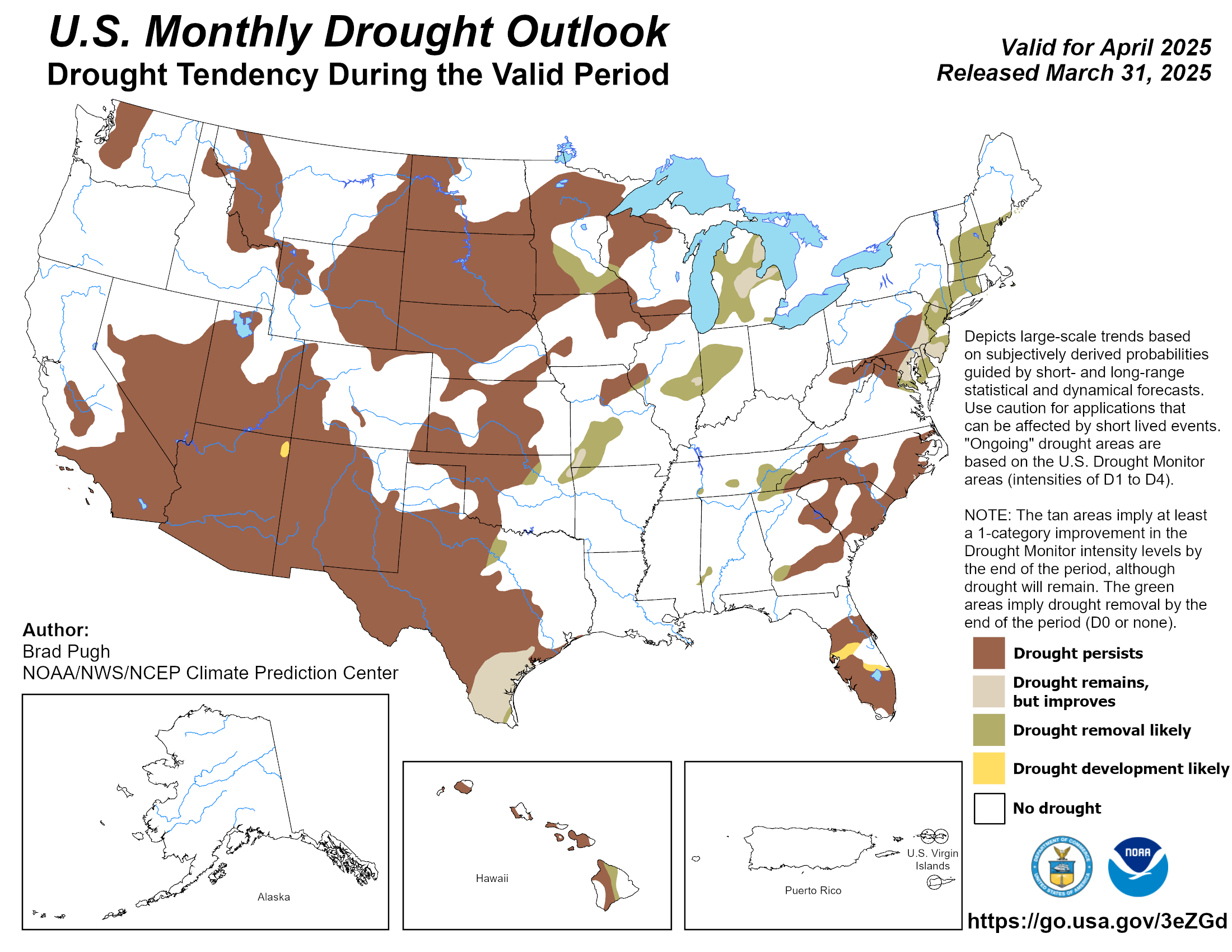
- Monthly national drought outlook updated -- Forecasters at NOAA's Climate Prediction Center recently released and updated their new US Monthly Drought Outlook that is to run through the end of August 2013. Although they foresee the persistence of drought across a large area of the western half of the nation, they fell some slight improvement could occur during August across sections of the central and southern Plains, extending into the southern Rockies. Unfortunately, the forecasters call for persistent drought conditions across sections of the central and southern Plains along with the central Rockies, the Intermountain West and California. [NOAA Climate Prediction Center] Note: a Monthly Drought Outlook Discussion is included describing the forecasters' confidence.
- Canadian national seasonal outlook issued -- Forecasters with Environment Canada issued their outlooks for temperature and precipitation across Canada for August, September and October 2013, which represents the last month of meteorological summer and the first two months of autumn. The temperature outlook indicates that a large section of Canada would experience above normal (1981-2010) temperatures for these three months, extending from British Columbia and the Yukon Territory eastward to Newfoundland and Labrador. Only few scattered areas across southern Ontario and along the Beaufort Sea in northern Yukon and Northwest Territories could expect below normal late summer-early autumn temperatures.
The Canadian precipitation outlook for late summer and into autumn 2013 indicates drier than normal conditions could be found across central Canada extending from northern British Columbia and southern Yukon Territory to Hudson Bay during the upcoming three months. On the other hand, above normal precipitation could be expected across southern sections of British Columbia and the western Prairie Provinces, southern Ontario and Quebec, along with several of the Maritime Provinces. Wetter than normal conditions were anticipated across the Arctic Archipelago.
[Note for comparisons and continuity with the three-month seasonal outlooks of temperature and precipitation generated for the continental United States and Alaska by NOAA's Climate Prediction Center, one would need to use Environment Canada's probabilistic forecasts for temperature and precipitation.]
PALEOCLIMATE RECONSTRUCTION
- Investigating the start of Earth's primitive chemistry --A research scientist at NASA's Jet Propulsion Laboratory recently coauthored three peer-reviewed papers investigating how life on Earth started. This scientist and his colleagues believe that Earth's first life began at alkaline hydrothermal vents at the bottom of oceans, where acetate would form from the product of methane and hydrogen from these vents and carbon dioxide dissolved in the surrounding ocean. The acetate could become the basis of other biological molecules. [NASA Jet Propulsion Laboratory]
CLIMATE IMPACTS ON THE BIOSPHERE
- Loss of Arctic sea ice has widespread effects on wildlife -- An international team of scientists including a biologist from Penn State University report that their examination of the relationships between ecological communities of marine and terrestrial animals in the Arctic indicates widespread consequences in the future as Arctic sea-ice continues to be lost due to changing climate conditions. Critical habitat for many species is being lost at an increasing rate, as sea ice has reached its lowest extent in 1500 years. [Penn State University News]
CLIMATE AND IMPACTS ON HUMAN HEALTH
- Link between climate and disease shows need to forecast future shifts for public health -- In light of increased evidence that climate change is affecting the worldwide spread of infectious diseases, an international team of disease ecologists propose that modeling the way disease systems respond to climate variables could help public health officials and environmental managers predict and mitigate the spread of lethal diseases.
[NOAA News]
CLIMATE AND SOCIETY
- Higher temperatures could result in more acts of aggression -- Researchers from Princeton University and the University of California-Berkeley report that based upon 60 studies obtained from a wide variety of disciplines, even slight increases in air temperature and changes in precipitation have led to greatly increased risks of personal violence and social upheaval through human history, extending over the last 12,000 years. The studies that were analyzed were from disciplines that included archaeology, criminology, economics and psychology. Apparently, weather extremes can cause humans to behave more aggressively and violently, leading to more violent crimes and war. The researchers warn that the projected 2 Celsius degree increase in global temperature would suggest more human conflict. [Princeton University News]
- Earthweek -- Diary of the Planet [earthweek.com] Requires Adobe Acrobat Reader.

Historical Events:
- 5 August 1843...A spectacular cloudburst at Chester Creek, near Philadelphia, PA turned the small creeks and streams entering the Delaware River into raging torrents. As much as sixteen inches of rain fell in just three hours at Concord, which still stands as the greatest amount of precipitation in a three-hour span in the U.S. (David Ludlum) (Intellicast)
- 5 August 1961...The temperature at Ice Harbor Dam, WA soared to 118 degrees to equal the state record established at Wahluke on 24 July 1928. The afternoon high of 111 degrees at Havre, MT was an all-time record for that location. (The Weather Channel)
- 5 August 1988...Floods ravaged parts of Sudan during August, the result of 8.27 inches of rain that fell in Khartoum in 13 hours on the 4th and 5th. The previous 24-hour record at Khartoum was 3.46 inches. More than one million people were made homeless. At least 96 died in Sudan's worst flooding since 1946. (Accord's Weather Guide Calendar)
- 5 August 1994...Fairbanks, AK soared to 93 degrees for the highest ever August temperature. (Intellicast)
- 5-6 August 1959...A bucket survey showed that thunderstorms dropped 16.70 inches of rain on parts of Decatur County, IA. The total was accepted as Iowa's 24-hour rainfall record. (The Weather Channel)
- 6 August 1905...Princeton, IN received 10.50 inches of rain, which established a 24-hour maximum precipitation record for the Hoosier State. (NCDC)
- 6 August 1918...Unusually hot weather began to overspread the Atlantic Coast States, from the Carolinas to southern New England. The temperature soared to an all-time record high of 106 degrees at Washington, DC, and Cumberland and Keedysville hit 109 degrees to establish a state record for Maryland. (David Ludlum)
- 6 August 1947...Sault Ste. Marie, MI hit 98 degrees, equaling the highest temperature ever recorded at that location. (Intellicast)
- 6 August 1987...Afternoon thunderstorms deluged Milwaukee, WI, breaking all previous rainfall records for the city. Among the records: 1.10 inches in 5 minutes, 3.06 inches in 1 hour, 5.24 inches in 2 hours, 6.24 in 6 hours and 6.84 inches in 24 hours. Floodwaters were four feet deep at the Milwaukee County Stadium, and floodwaters filled the basement of the main terminal at the airport. Flooding caused 5.9 million dollars damage, and claimed the life of one person. (The National Weather Summary) (Storm Data)
- 7 August 1918...Philadelphia, PA established an all-time record with a high of 106 degrees. New York City experienced its warmest day and night with a low of 82 degrees and a high of 102 degrees. Afternoon highs of 108 degrees at Flemington, NJ and Somerville, NJ established state records for the month of August. (The Weather Channel) (Sandra and TI Richard Sanders - 1987)
- 7 August 1949...The hottest day on record for Winnipeg, Manitoba occurred when the temperature reached 105 degrees. (The Weather Doctor)
- 7 August 1969...Cuba's hottest day on record when the temperature reached 101.5 degrees at Guantánamo, Cuba. (The Weather Doctor)
- 7 August 1983...The temperature at Thunder Bay, Ontario reached an all-time record high of 104 degrees. (The Weather Doctor)
- 7-8 August 1995...Lockington Dam, OH recorded 10.75 inches of rain, establishing a 24-hour maximum precipitation record for the Buckeye State. (NCDC)
- 7 August 2004...Iceland's hottest August day on record as the temperature at Skaftafell, Iceland reached 84.4 degrees. (The Weather Doctor)
- 8 August 1878...The temperature at Denver, CO soars to an all-time record high of 105 degrees. (The Weather Channel)
- 8 August 1983...The temperature at Big Horn Basin, WY reached 115 degrees to establish a state record for the Cowboy State. (The Weather Channel)
- 9 August 1930...The temperature reached 113 degrees at Perryville, TN to establish an all-time maximum temperature record for the Volunteer State. (NCDC) (Intellicast)
- 9 August 1960...Vancouver (British Columbia) International Airport's hottest day on record as the mercury hit 91.4 degrees (The Weather Doctor)
- 9 August 2003...The Bavarian city of Roth, Germany had a temperature that hit 105 degrees, a new national record. (The Weather Doctor)
- 10 August 1898...The temperature at Pendleton, OR climbed all the way to 119 degrees to tie the state record set two weeks previously at Prineville. (The Weather Channel)
- 10 August 1936...The temperature soared to 114 degrees at Plain Dealing, LA, and reached 120 degrees at Ozark, AR, to establish record highs for those two states. (The Weather Channel)
- 10 August 1988... The temperature reached 102 degrees at Ely, NV breaking the all-time record there. (Intellicast)
- 10 August 2003...A heat wave continued across the British Isles. At Gravesend in southern England, a new national heat record was set as the mercury soared to 100.58 degrees. The heat forced rail service officials across Britain to limit train speeds to 60 mph because of fears the tracks could buckle. Londoners experience their hottest recorded day in the London's history when the temperature hit 100.22 degrees, which was the first ever time that the temperature went over 100 degrees at Heathrow Airport. (The Weather Doctor)
- 11 August 1914...The temperature at Northwest River, Labrador soared to an all-time Labrador record high of 107 degrees. (The Weather Doctor)
- 11 August 1933...The unofficial shade temperature at San Luis, Mexico reached 58 degrees Celsius (136.4 degrees Fahrenheit), for share of the world record with Aziziyah, Libya. (The Weather Doctor)
- 11 August 1944...The temperature at Burlington, VT soared to an all-time record high of 101 degrees. (The Weather Channel)
- 11 August 2003...The temperature at Turin, Italy hit 107 degrees, marking the hottest day in over the 250 years that temperature readings have been recorded. (The Weather Doctor)
- 11 August 2004...The temperature at Reykjavík, Iceland reached 76.6 degrees, the hottest day ever recorded in the city where record have been kept since the 19th century. (The Weather Doctor)
- 11 August 2007...Dutch Harbor/Unalaska Airport, AK set its all-time high temperature with a reading of 81 degrees. (The Weather Doctor)
Return to DataStreme
ECS website
Prepared by Edward J. Hopkins, Ph.D., email hopkins@meteor.wisc.edu
© Copyright, 2013, The American Meteorological Society.