WEEKLY CLIMATE NEWS
28 July-1 August 2014
DataStreme Earth Climate System will return for Fall 2014 with
new Investigations files starting during Preview Week, Monday, 25 August 2014. All the current online website products will continue to be available throughout the summer break period.
ITEMS
OF INTEREST
- New York State farmer honored for 84 years of service as a volunteer weather observer -- This past Sunday, officials with the local National Weather Service office for the New York City metropolitan area will present an award to Richard G. Hendrickson, a 101-year old farmer for his 84 years of service to the nation as filing twice daily weather reports from his farm near Bridgehampton near the eastern end of Long Island. He has collected and reported his observations of daily temperature, precipitation, wind and any other significant weather from the weather observing station on his farm since 1930. The National Weather Service's Cooperative Observer Program will name their new 80-year service award in honor of Mr. Hendrickson. [NOAA News]
- Stunning pictures of Earth from Apollo 11 -- On the occasion of last week's 45th anniversary of the first manned landing on the Moon by NASA's Apollo 11 astronauts, two photographs of Earth made by these astronauts were recently posted. These historic photographs made as the astronauts on their way to the Moon show planet Earth in a way that few humans have personally experienced. [NASA Earth Observatory]
- Massive mayfly emergence tracked on Doppler radar -- Last Sunday night, the National Weather Service's WSR-88D (Doppler) radar unit at La Crosse, WI detected an interesting echoes that were associated with a massive emergence of mayflies (short-lived insects belonging to the order Ephemeroptera) along the upper Mississippi Valley in the tri-state area of Wisconsin, Iowa and Minnesota. Apparently, a large hatch of these mayflies occurred due to cool summer weather conditions. The mayflies covered the ground, vehicles and structures along the Mississippi River, with several vehicular accidents caused by slippery road conditions due to the crushed mayflies. [La Crosse, WI NWS Forecast Office]
- A celebration -- Friday, 1 August 2014, is the ancient Celtic holiday of Lammas that corresponds to one of the cross quarter days, lying nearly halfway between the summer solstice (21 June 2014) and the autumnal equinox (23 September 2014). This holiday, also known as "loaf-mass day", originally marked the first wheat harvest of the year in the British Isles. [Editor's note: The following Thursday, 7 August 2014, represents the exact halfway point between the dates of the solstice and equinox. EJH]
- In the Land of the Midnight Sun -- The sun will set at Barrow, AK early Saturday morning (2:03 AM AKDT on 2 August 2014), marking the first time in nearly 12 weeks (since 10 May 2014) that the sun has gone below the local horizon. However, the sun will remained below the horizon for 62 minutes before rising at 3:05 AM on Saturday. On each day until mid-November, the length of night will increase at Barrow. On the afternoon of 18 November 2014, the sun will set and remain below the horizon for a stretch of two months until late January 2015, when the sun will reappear above the horizon for slightly more than one hour.
- High-quality maps of August temperature and precipitation normals across US available -- The PRISM Climate Group at Oregon State University's website has prepared high-resolution maps depicting the normal maximum, minimum and precipitation totals for August and other months across the 48 coterminous United States for the current 1981-2010 climate normals interval. These maps, with a 800-meter resolution, were produced using the PRISM (Parameter-elevation Regressions on Independent Slopes Model) climate mapping system.
- August weather calendar for a city near you -- The Midwestern Regional Climate Center maintains an interactive website that permits the public to produce a ready to print weather calendar for any given month of the year, such as August, at any of approximately 270 weather stations around the nation. (These stations are NOAA's ThreadEx stations.) The entries for each day of the month includes: Normal maximum temperature, normal minimum temperature, normal daily heating and cooling degree days, normal daily precipitation, record maximum temperature, record minimum temperature, and record daily precipitation; the current normals for 1981-2010.
CURRENT
CLIMATE STATUS
- Visualizing drought history across the nation -- The New York Times has posted an updated version of their interactive page entitled "Mapping the Spread of Drought across the U.S." that contains several products obtained from the US Drought Monitor produced by the National Drought Mitigation Center. These products included an animated map of the status of drought conditions across the nation that has been updated on a weekly basis, graphs of Drought Severity from the Drought Monitor for the last ten years and an extended and detailed graphic depicting the history of monthly variations of the Palmer Drought Severity Index across the nation since January 1895. [New York Times: The Upshot]
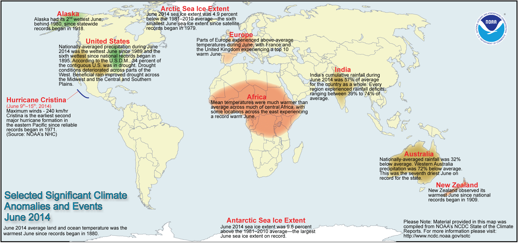
- Global temperature and ice cover for June 2014 reviewed -- Scientists at the NOAA National Climatic Data Center
recently reported on their analysis of preliminary weather data collected during the month of June 2014:
- The combined global land and ocean surface temperature for June
2014 was 61.2 degrees Fahrenheit, which was the highest for any month of June since sufficiently detailed global climate records
began in 1880. The global temperature for June 2014 was 1.30 Fahrenheit degrees above the 20th
century (1901-2000) average. This record high June temperature follows a record warm May 2014.
When considered separately,
the average land temperature for June 2014 was the seventh highest for any June since
1880, while the temperature over the oceans was the highest for
any June. In fact, this ocean temperature (expressed as a departure from average) was the highest for any month on record.
- The researchers at the National Snow and Ice Data Center noted the areal extent of the Arctic sea ice
for June 2014 was
the sixth smallest since satellite surveillance began in 1979. On the
other hand, the extent of the Antarctic sea ice was the largest
in the 36-year record. [NOAA/NCDC
State of the Climate]
- A global map of Selected Significant Climate Anomalies and Events for March 2013 is available from NCDC.
CURRENT
CLIMATE MONITORING
- Satellites see groundwater deficit across wide areas of the West -- A nationwide map describing the underground water storage (aquifers) in early July with respect to long-term averages was produced by the National Drought Mitigation Center at the University of Nebraska-Lincoln and the NASA Goddard Space Flight Center from gravimetric data collected from NASA's twin Gravity Recovery and Climate Experiment (GRACE) satellites. The map, described in terms of "wetness percentile," indicates that while many areas across the West are experience drought, the groundwater storage across the Southwest is extremely low meaning that the region's aquifers are not being replenished. [NASA Earth Observatory]
In a study conducted by scientists from NASA and the University of California–Irvine, more than 75 percent of the water lost from the drought-stricken Colorado River Basin since 2004 was found to be lost from underground sources.
[NASA Headquarters]
- An All-Hazards
Monitor -- This Web portal provides the user information from NOAA on
current environmental events that may pose as hazards such as tropical
weather, fire weather, marine weather, severe weather, drought and
floods. [NOAAWatch]
CLIMATE IMPACTS ON THE BIOSPHERE
- Range of caribou and hunter's access could be altered by climate change -- In research conducted by scientists with the US Geological Society and the University of Alaska-Fairbanks, a distinct possibility exists that fewer caribou would be found in the future across sections of interior Alaska and Canada's Yukon Territory due to changing climate. Increasing temperatures across this region of the Arctic along with wildfires would reduce the amount of winter habitat for the caribou, causing them to shift their wintering grounds. The decline of the caribou in certain areas could also have an impact on some communities where the inhabitants have depended upon hunting caribou for survival. [USGS Newsroom]
CLIMATE FORECASTS
- Amazon forest fire season for 2014 foreseen to be quiet -- Researchers from NASA's Goddard Space Flight Center and the University of California, Irvine gave made a forecast of the fire season severity for 2014 across South America's Amazon Basin using a model developed at NASA that utilizes historical fire data obtained from NASA's Terra satellite, sea surface temperature data acquired from NOAA buoys and soil moisture change data from the NASA/German Aerospace Center (DLR) Gravity Recovery and Climate Experiment (GRACE) mission. These scientists foresee the 2014 fire season to be below-averae in the 10 regions across the Amazon Basin. [NASA's Earth Science News Team]
- Internal variability in North Atlantic could affect seasonal hurricane outlooks -- Scientists at the National Center for Atmospheric Research (NCAR) and South Africa's North-West University have found that internal variability in the North Atlantic basin can make one season twice as active as another, even when El Niño and other large-scale hurricane-shaping elements remain unchanged. This internal variability involve processes that unfold without being dictated by larger-scale features. The results of simulations conducted by the researchers suggest that seasonal hurricane forecasts could be improved by conveying the amount of unavoidable uncertainty in the outlook. [NCAR/UCAR AtmosNews]
CLIMATE AND SOCIETY
- Earthweek -- Diary of the Planet [earthweek.com] Requires Adobe Acrobat Reader.

Historical Events:
- 28 July 1930...The temperature at Greensburg, KY soared to 114 degrees to set a state record. (The Weather Channel)
- 28 July 1934...The temperature at Orofino, ID climbed to 118 degrees to establish a record for Idaho. (The Weather Channel)
- 28 July 1995...Yuma, AZ reached its all-time high temperature reading with 124 degrees. (Intellicast)
- 29 July 1898...The temperature at Prineville, OR soared to 119 degrees to establish a state record, which was tied on the 10th of August of that same year at Pendleton. (The Weather Channel)
- 29 July 1930...Mississippi's record high temperature of 115 degrees was set at Holly Springs. (Intellicast)
- 30 July 1949...The state record temperature for Connecticut was established when the town of Greenville registered an afternoon high of 102 degrees. (The Weather Channel)
- 30 July 1965...The temperature at Portland, OR reached 107 degrees to equal their all-time record high. (The Weather Channel)
- 31 July 1861...Numerous world rainfall records were set at Cherrapunji, India as of this last day of July. These records include: 366.1 inches for a single 31-day month (during July 1861); 502.63 inches for two months (June-July 1861); 644.44 inches for three months (May-July 1861); 737.72 inches for four months (April-July 1861) and 1041.78 inches for 12 months (Aug. 1860-July 1861). (WMO, NWS)
- 31 July 1991...Roswell, NM closed out the month with a total of 6.68 inches of rain to set a new record for the month. (Intellicast)
- 31 July 1986...The temperature at Little Rock, AR soared to 112 degrees to establish an all-time record high for that location. Morrilton, AR hit 115 degrees, and daily highs for the month at that location averaged 102 degrees. (The Weather Channel)
- 1 August 1977...Excessive rains at Muduocaidang, China were responsible for establishing two world records, to include 33.07 inches in 6 hours and 55.12 inches in 10 hours. (WMO, NWS)
- 1 August 1985...A nearly stationary thunderstorm deluged Cheyenne, WY with rain and hail. Six inches of rain fell in six hours producing the most damaging flash flood of record for the state; a 24-hour precipitation record for the Cowboy State was also established with 6.06 inches. Two to five feet of hail covered the ground following the storm, which claimed twelve lives and caused 65 million dollars property damage. (Storm Data)
- 1 August 1993...San Francisco, CA hit 98 degrees, the hottest ever recorded for the city in August. (Intellicast)
- 3 August 1898...Philadelphia, PA had one of its worst thunderstorms ever when 5.84 inches fell in just 2 hours. The hydraulic pressure in the city sewers due to the force of the accumulated runoff caused overflows in toilets, basins and sinks to rise to second-floor levels in some cases. (Intellicast) (Accord's Weather Guide Calendar)
- 3 August 1914...Temperature reached an all-time August high of 96 degrees for Calgary, Alberta. (The Weather Doctor)
- 3 August 1970...Hurricane Celia made landfall near Port Aransas on the Texas coast, producing wind gusts to 161 mph at Corpus Christi, and estimated wind gusts of 180 mph at Arkansas Pass. Even at Del Rio, 250 miles inland, Celia produced wind gusts to 89 mph. The hurricane was the most destructive of record along the Texas coast causing 454 million dollars damage as 8950 homes were destroyed on the Coastal Bend. Celia also claimed eleven lives and injured 466 people. (David Ludlum) (The Weather Channel) (Intellicast)
- 3 August 1987...Beckley, WV established an all-time record with an afternoon high of 93 degrees. (The National Weather Summary)
- 3 August 1990...Highest temperature recorded in the United Kingdom prior to 2003 heat-wave was 98.8 degrees at Cheltenham, England: (The Weather Doctor)
- 3 August 1995...South Bend, IN received 4.83 inches of rain in 24 hours to set the city's greatest daily rainfall record. (Intellicast)
Return to DataStreme
ECS website
Prepared by Edward J. Hopkins, Ph.D., email hopkins@meteor.wisc.edu
© Copyright, 2014, The American Meteorological Society.