WEEKLY CLIMATE NEWS
20-24 June 2016
DataStreme Earth Climate System will return for Fall 2016 with
new Investigations files starting during Preview Week, Monday, 22 August 2016. All the current online website products will continue to
be available throughout the summer break period.
ITEMS
OF INTEREST
- Happy Summer Solstice! The summer solstice will occur next Monday (officially, 20 June 2016 at 2234 Z, or
6:34 PM EDT, 5:34 PM CDT, etc.). At that time, the earth's spin axis is oriented such that the sun appears to be the farthest north in the local sky of most earth-bound observers. While most of us consider this event to be the start of astronomical summer, the British call the day the "Midsummer Day", as the apparent sun will begin its southward descent again. For essentially all locations in the Northern Hemisphere, daylight on Sunday will be the longest and the night will be the shortest of the year. Starting Monday, the length of darkness will begin to increase as we head toward the winter solstice on 21 December 2016 at 1044 Z. However, because the sun is not as perfect a time-keeper as a clock, the latest sunsets of the year at many mid-latitude locations will continue through about the first week of July -- a consequence of the earth being near aphelion (on 4 July 2016) and the apparent sun moving across the sky well to the north of the celestial equator.
- World Hydrography Day celebration -- The
International Hydrographic Organization (IHO) will celebrate its annual
World Hydrography Day on Tuesday, 21 June 2016, the 95th-anniversary
date on which the IHO was created in 1921. The theme for this year's
celebration is
"Hydrography - the key to well-managed seas and waterways," which is intended to focus the public's attention upon the importance of hydrography and the knowledge gained of the shape, nature and depth of the seafloor for the safe and sustainable use of the global oceans and other waterways.
[International
Hydrographic Organization]
CURRENT
CLIMATE MONITORING
- Nation's May drought report -- NOAA's National Centers for Environmental Information (NCEI) has posted its May 2016 drought report online. Using the Palmer Drought Severity Index, approximately two percent of the contiguous United States experienced severe to extreme drought conditions at the end of May, while 12 percent of the area had severely to extremely wet conditions.
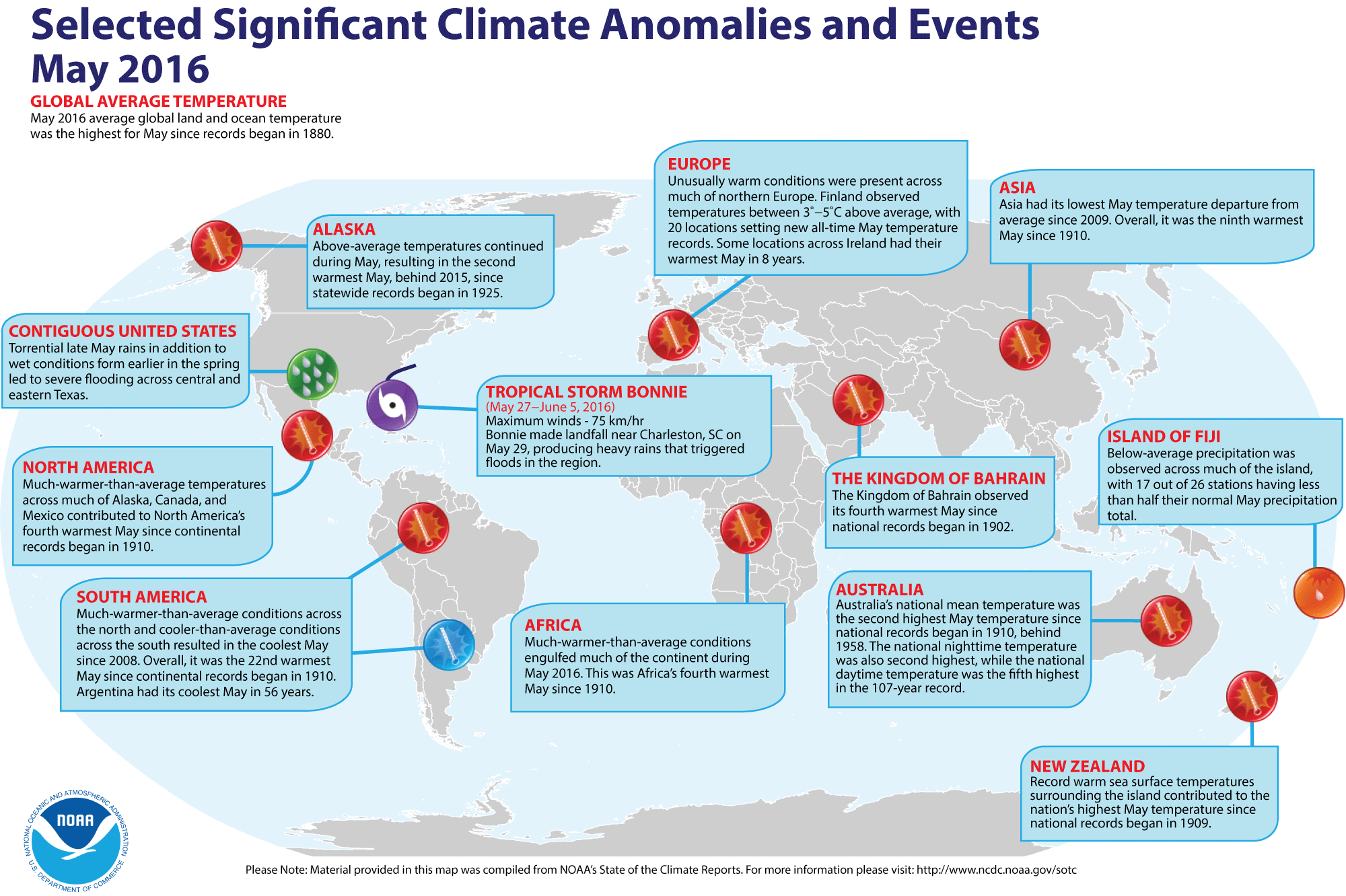
- Review of global weather and climate for May 2016 -- Scientists at NOAA's National Centers for Environmental Information (NCEI) report that the recently concluded month of May was the warmest May since sufficiently dense global climate records began in 1880. They based their report on preliminary calculations of the combined global land and ocean surface temperature for May 2016, which was 1.57 Fahrenheit degrees (0.87 Celsius degrees) above the 20th century (1901-2000) average May temperature of 58.6 degrees Fahrenheit. While this May 2016 global land and ocean temperature was a record, the temperature departure from the 20th-century average was the smallest monthly departure since August 2015 as it did not surpass 1.0 Celsius-degree for the first time in six months. When considered separately, the average May 2016 land surface temperature was 2.11 Fahrenheit degrees above the 20th century average, which meant that this land surface temperature was the third highest May land temperature since 1880. The global ocean surface temperature for May 2016 was 1.37 Fahrenheit degrees above the 20th century average, which represented a record May sea surface temperature.
In addition, the combined global land and ocean surface temperature for the last three months (March through May), which is considered meteorological spring in the Northern Hemisphere (fall in the Southern Hemisphere), was the highest since 1880. Furthermore, the ocean and land surface temperatures for this three-month interval were each records.
[NOAA/NCEI State of the Climate]
The May sea ice extent data for the Arctic Ocean and the waters around Antarctica were unavailable from the National Snow and Ice Data Center because of issues with the sensor onboard the Defense Meteorological Satellite Program (DMSP) F-17 satellite. [National Snow & Ice Data Center]
According to data from the Rutgers Global Snow Lab, the Northern Hemisphere snow cover extent for May was the fourth smallest in the 50-year period of record.
A global map of Selected Significant Climate Anomalies and Events for May 2016 is available from NCDC.
- Milestones in atmospheric carbon dioxide levels reached around the globe -- During this past week the lead scientist for NOAA's Global Greenhouse Gas Reference Network reported that as of 23 May 2016, atmospheric carbon dioxide levels measured at the South Pole Station had surpassed 400 parts per million by volume (ppmv) for the first time in four million years. [NOAA News]
In a separate report, climate scientists with the United Kingdom's Met Office and the University of Exeter along with California's Scripps Institution of Oceanography noted that 2016 has an excellent chance of being the first year where the Mauna Loa atmospheric carbon dioxide record with be above the 400 ppmv level all-year around. The 400-ppmv level for carbon dioxide represents a symbolic threshold. The scientists claim that the strong El Niño event at the start of the year contributed to the rapid increase in the atmospheric carbon dioxide. [UK Met Office News]
- Annual Greenhouse Gas Index is updated -- Scientists in the Global Monitoring Division of the NOAA Earth System Research Laboratory recently provided an update of NOAA's Annual Greenhouse Gas Index (AGGI) for the calendar year 2015. The AGGI is an index that considers the combined influence that a set of long-lived greenhouse gases have upon the Earth's surface temperature, scaled to the influence these gases would have had in 1990, the year when the UN Kyoto Protocol was signed by nations to reduce emissions of the gases. The main greenhouse gases considered are carbon dioxide (CO2), methane (CH4), nitrous oxide (N2O) and halogenated compounds (such as CFC11 and CFC12). According to this most recent annual update, the AGGI for 2015 was 1.37, which means that at the end of the calendar year 2015, the warming influence of greenhouse gases had risen 37 percent above the 1990 baseline value. The scientists also calculated the total contribution of greenhouse gases would be equivalent to 485 ppmv (parts per million by volume) of CO2, of which the actual concentration of CO2 was 399 ppmv. The AGGI is calculated from air samples collected weekly from approximately 100 clean-air stations around the world. [NOAA Climate.gov News]
Note: The details of the AGGI and tables of data that include the annual values of AGGI, the global radiative forcing by CO2, CH4, N2O, CFC11 and CFC12 along with 15 minor greenhouse gas constituents are listed from 1979 through 2015. In addition, annual CO2-equivalent totals are also provided. [Global Monitoring Division, NOAA Earth System Research Laboratory]
- Carbon dioxide emissions human activities found to outweigh those from volcanoes-- A feature article written by climate scientists, reveals that according to current estimates, human activities appear to emit at least sixty times more carbon dioxide into the atmosphere each year than the amount of this greenhouse gas released by volcanoes. These conclusions were based upon data obtained from the Carbon Dioxide Information Analysis Center at the US Department of Energy's Oak Ridge National Laboratory and from the US Geologic Survey. [NOAA Climate.gov News]
- Animation shows seasonal changes in areas across nation experiencing high probabilities of severe weather -- A 26-second animation of maps was produced by NOAA's Storm Prediction Center showing the day-to-day changes in the historical probability of severe weather events (tornadoes, thunderstorm winds over 58 mph and/or hail larger than three-quarters of an inch in diameter) occurring within 25 miles of a given location based upon the reported storm events between 1982 and 2011. Attention is directed to the expansion of the area of highest potential of severe weather to the north and west from the lower Mississippi Valley in late winter to the central Plains and Midwest by summer, followed by shrinkage of the region in fall. [NOAA Climate.gov News]
- Light pollution atlas shows one third of world's population unable to see Milky Way -- A team of US and Italian scientists have created a new global atlas of artificial night sky brightness (or light pollution), which reveals that more than one third of the world's population are now unable to view the Milky Way in the nighttime sky because of the presence of artificial lights especially in developed countries that raise night sky luminance. In the United States, approximately 80 percent of Americans would not see the Milky Way. The researchers produced their new atlas of light pollution using high¬-resolution data from the NOAA-NASA Suomi NPP satellite and precision sky brightness measurements from ground based station. Their study represents the most accurate assessment of the global impact of light pollution to date. In addition to robbing humans of the opportunity to see the celestial bodies in the night sky, light pollution can confuse or expose wildlife like insects, birds and sea turtles to harm. [NOAA Office of Oceanic & Atmospheric Research News]
CLIMATE FORCING
- Daytime temperatures in summer more responsive to late spring rains than do nighttime temperatures -- Extending upon his discussion of the role late summer rainfall plays upon summer average temperatures across the nation that appeared in the previous entry on his "Beyond the Data" blog, Deke Arndt, Chief of the Climate Monitoring Branch at NOAA's National Centers for Environmental Information, described how the afternoon temperatures during summer (June-August) across a large part of the nation appear to "listen to" the late spring precipitation. He prepared maps showing the relationships of summer afternoon or maximum daytime temperatures and June precipitation along with corresponding relationships between the minimum or early morning temperatures and June precipitation. These data were based on 121 years (1895-2015) of record. He found that a strong relationship between the summer daytime maximum temperatures and late spring rain, with many of the 344 climate divisions across the contiguous United States experiencing lower temperatures, or cooler conditions, following the late spring rains. On the other hand, no convincing relationship between early morning minimum temperatures for summer and June rainfall for many of the climate divisions, except for a few divisions across Texas and the southern Plains where more spring rain would result in lower temperatures. Interestingly, sections of northern New England and New York State tend to have a reverse relationship in which more spring rain go along with higher summer temperatures. [NOAA Climate.gov News]
CLIMATE FORECASTS
- New Seasonal Climate Outlooks for this summer
and early fall issued -- Near the end of last week, forecasters at the NOAA
Climate Prediction Center (CPC) released their new national Three-Month
(Seasonal) Climate Outlooks for July through September 2016, corresponding to the last two
months of the meteorological summer season (in the Northern Hemisphere)
and the first month of meteorological autumn. Specific details of
their outlooks include:
- Temperature and precipitation outlooks -- According to their temperature
outlook, nearly all of the contiguous United States along with Alaska should experience a high chance of above average temperatures
for these three upcoming months. The western third of the "lower 48 States" along with sections of the Southeast and Northeast appear to have a good chance for having above average temperatures. Only sections of coastal and southern Texas could have nearly equal
chances of warmer or cooler than normal conditions.
Their precipitation
outlook calls for better than even chances of dry conditions
for the summer and early autumn of 2016 across the Northwest, with the highest probability of dry conditions centered on interior sections of Washington, Oregon and northern Idaho. Conversely, the
outlook would suggest a good chance of a wet summer along the Gulf coast, running from south Texas eastward to Florida and also in the northern Plains, centered on South Dakota and western Minnesota. The rest of the 48 contiguous states should have equal chances
of below and above average summer-early fall precipitation.
A summary
of the prognostic discussion of the 3-month outlook for
non-technical users is available from CPC. These forecasts were based
in part that a La Niña event with below average sea surface temperatures across the equatorial Pacific was expected to develop by before fall. A description is also provided as how to read these 3-class, 3-month Outlook maps.
- Seasonal Drought Outlook released -- The
forecasters at NOAA's Climate Prediction Center also released their US
Seasonal Drought Outlook last week that would run from
late-June through September 2016. Their outlook would call for
persistence of drought conditions across most of California and adjacent areas of southern Oregon, western Nevada and Arizona. Additional areas across Montana and Wyoming in the West, along with the Tennessee Valley in the Southeast should also continue seeing drought conditions. Furthermore, a large section of the Northwest, including Washington, Oregon, northern Idaho and northwestern Montana could experience development of drought conditions over the summer. Areas across southeastern Arizona and southwestern New Mexico could experience improvement in drought conditions that could even result in possible removal from drought status.
Note: a Seasonal
Drought Outlook Discussion is included describing the
forecasters' confidence.
CLIMATE
AND SOCIETY
- Public finds climate scientists to be more credible if they practice what they preach -- A researcher from Indiana University and her colleagues found that two large online surveys of approximately 3000 Americans revealed that these survey participants appear to be more likely to follow the advice concerning personal energy use from climate scientists who practice reducing their own carbon footprint. [Science Daily News]
- Earthweek -- Diary of the Planet [earthweek.com]
Historical Events:
- 20 June 1921...Circle, MT received 11.50 inches of rain in 24 hours, a
record for the state. The town of Circle received a total of 16.79 inches
of rain that month to establish a rainfall record for any town in Montana
for any month of the year. (The Weather Channel)
- 20 June 1970...Norway's hottest day on record occurred, as the
temperature at Nesbyen, Norway peaked at 96.1 degrees. (The Weather Doctor)
- 20 June 2000...The town of Barrow on Alaska's North Slope experienced
its first recorded thunderstorm, which dropped 0.16 inches (4.1 mm) of rain
in just a couple minutes. (The Weather Doctor)
- 21 June 1942...The temperature at Tirat Tsvi, Israel reached 129
degrees, the highest temperature ever recorded in Asia. (The Weather
Doctor)
- 22 June 1947...Heavy rains deluged Holt, MO as a foot of rain fell in
42 minutes, still a world's record rainfall rate for the fastest foot of
rain accumulation. (The Weather Doctor)
- 22 June 1987...Thunderstorms in New York State produced 5.01 inches of
rain in 24 hours at Buffalo, an all-time record for that location.
The temperature at Fairbanks, AK soared to 92 degrees, establishing a
record for the date. (The National Weather Summary) (Storm Data)
- 22 June 1988...Tucson, AZ reported an all-time record high of 114
degrees, surpassing the previous record of 112 degrees established a day
earlier. Highs of 98 degrees at Pittsburgh, PA and 100 degrees at
Baltimore, MD tied records for the month of June. (The National Weather
Summary)
- 22 June 2003...The largest recorded hailstone in the United States fell
on Aurora, NE. The diameter of this hailstone was 7 inches, and its
circumference was 18.75 inches. (Northern Indiana NWSFO) The National Weather Service reported this hailstone to be the second largest ever documented in the U.S. by weight, and the largest by size at that time. Currently, the world's largest hailstone is recognized to be 8 inches in diameter and 1.9375 lbs. that was produced from storms in South Dakota on 23 July 2010. (National Weather Service files)
The
mercury peaked at 95 degrees in the northern community of Moosonee,
Ontario, the hottest June day ever recorded here. (The Weather Doctor)
- 23 June 1902...The temperature at Volcano Springs, CA
soared to 129 degrees to set a June record high temperature for the
U.S. (Sandra and TI Richard Sanders)
- 23 June 1982...The temperature fell to all-time record low
of 117 degrees below zero for Antarctica's South Pole Weather Station.
(The Weather Doctor)
- 24 June 1946...Mellen, WI received 11.72 inches of rain,
setting a 24-hour maximum precipitation record for the Badger State.
(NCDC)
- 24 June 1972...Paradise Ranger Station in Washington's Rainier National Park had 4.4 inches of snow on this day. This snowfall turned out to be the
last for the 1971-72 season and brought the seasonal total to
1122 inches -- a new single season snowfall record for the U.S.
at that time. (Intellicast)
- 24 June 1988...Forty-three cities reported record high
temperatures for the date. Valentine, NE reported an all-time record
high of 110 degrees, and highs of 102 degrees at Casper, WY, 103
degrees at Reno, NV, and 106 degrees at Winnemucca, NV were records for
the month of June. Highs of 98 degrees at Logan, UT and 109 degrees at
Rapid City, SD equaled June records. (The National Weather Summary)
(Storm Data)
- 25 June 1925...The mercury hit 101 degrees at Portland, OR,
their earliest 100 degree reading of record. (Sandra and TI Richard
Sanders)
- 25 June 1953...The temperature at Anchorage, AK soared to
86 degrees, their highest reading of record. (The Weather Channel)
- 25 June 1988...Fifty-two cities in the central and eastern
U.S. reported record high temperatures for the date. Highs of 100
degrees at Erie, PA and 104 degrees at Cleveland, OH established all-
time records for those two locations. Highs of 101 degrees at Flint,
MI, 105 degrees at Chicago, IL, and 106 degrees at Fort Wayne, IN
equaled all-time records. (The National Weather Summary) (Storm Data)
Southwestern Ontario experienced a heat wave as the mercury soared to
104.4 degrees in Windsor and 100.8 degrees in London, the hottest day
ever recorded in these cities. (The Weather Doctor)
- 26 June 1931...The temperature soared to 92 degrees at
Anchorage, AK, the highest reading of record to date for that city.
(The Weather Doctor)
Return to DataStreme ECS RealTime Climate Portal
Prepared by Edward J. Hopkins, Ph.D., email hopkins@aos.wisc.edu
© Copyright, 2016, The American Meteorological Society.