WEEKLY CLIMATE NEWS
25-29 July 2016
DataStreme Earth Climate System will return for Fall 2016 with
new Investigations files starting during Preview Week, Monday, 22 August 2016. All the current online website products will continue to
be available throughout the summer break period.
ITEMS
OF INTEREST
- A climate education workshop to focus on rising tides and changing times -- A workshop titled "Rising Tides and Changing Times" will be held on Wednesday, 3 August 2016, for formal and informal educators in Charleston, SC as part of NOAA's Climate Stewards Education Project (CSEP). This workshop is one of four climate-science workshops around the country that are being convened by NOAA together with a variety of federal, state and non-governmental organization partners. Although participation is free, registration for this Charleston workshop is required. [NOAA Climate.gov Education]
- Worldwide GLOBE at Night 2016 Campaign is underway -- The eighth in the series of GLOBE at Night citizen-science campaigns for 2016 will continue through Saturday, 6 August. GLOBE at Night is a worldwide, hands-on science and education program designed to encourage citizen-scientists worldwide to record the brightness of their night sky by matching the appearance of a constellation (Cygnus in the Northern Hemisphere and Sagittarius in the Southern Hemisphere) with the seven magnitude/star charts of progressively fainter stars.
Activity guides are also available. The GLOBE at night program is intended to raise public awareness of the impact of light pollution.
The next series in the 2016 campaign is scheduled for 25 August-2 September 2016. [GLOBE at Night]
- Remembering North Carolina's Great Flood of 1916 -- The start of last weekend marked the 100th anniversary of a disastrous and deadly flood called the "Great Flood of 1916" that swept through Asheville and other nearby areas of western North Carolina. Torrential rain across the region caused the normally shallow French Broad and Swannanoa Rivers to jump their banks. Several dozen people lost their lives in Asheville and hundreds of homes, businesses were either destroyed or damaged. The flooding appears to have been the result of the slow moving remnants of two tropical systems from off the Gulf of Mexico and the western North Atlantic brought heavy rainfall to western North Carolina. [NOAA NCEI News]
CURRENT
CLIMATE STATUS
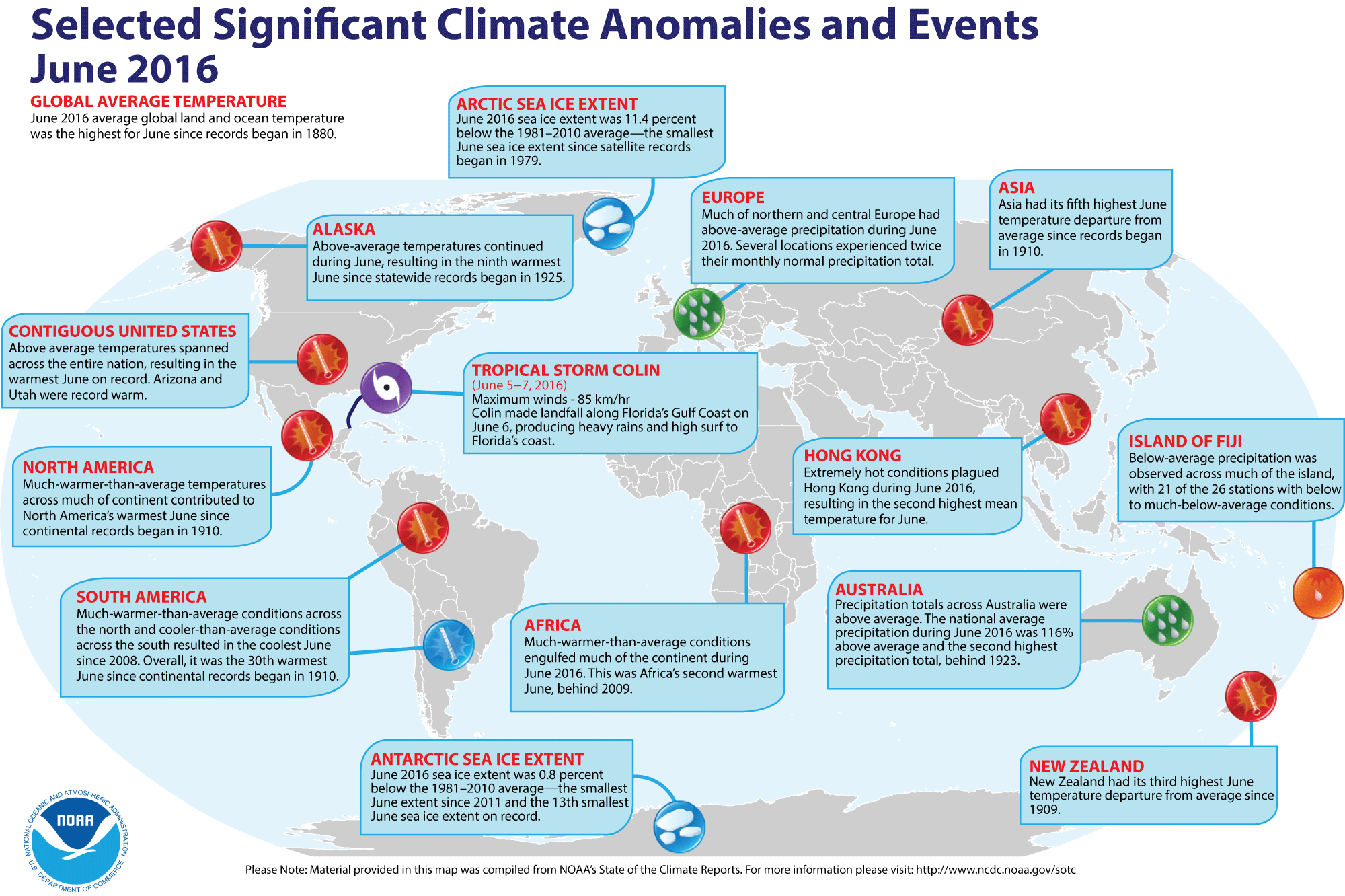
- Global temperature and ice cover for June 2016 reviewed -- Scientists at the NOAA National Centers for Environmental Information (NCEI)
recently reported on their analysis of preliminary weather data collected during the month of June 2016:
- The combined global land and ocean surface temperature for June
2016 was 1.62 Fahrenheit degrees above the 20th
century (1901-2000) average, which was the highest for any month of June since sufficiently detailed global climate records
began in 1880. This June 2016 temperature exceeded the previous June record set last year (2015) by 0.04 Fahrenheit degrees. When considered separately,
the average ocean temperatures for June 2016 was the highest for
any June, while the average land surface temperature for this past month tied June 2015 for the highest June temperature during the 137-year record. Furthermore, the average surface temperatures for land, ocean and combined land-ocean through the first six months of the year (January through June 2016) were the highest for the first half of any year since 1880.
- The researchers at the National Snow and Ice Data Center noted the areal extent of the Arctic sea ice
for June 2015 was
the smallest since satellite surveillance began in 1979. On the
other hand, the extent of the Antarctic sea ice was the thirteenth smallest
in the 38-year record. [NOAA/NCEI
State of the Climate]
- A global map of Selected Significant Climate Anomalies and Events for June 2016 is available from NCEI.
Using their own techniques to analyze the ground-based observations and satellite data, scientists at NASA's Goddard Institute for Space Studies (GISS) also noted that each of the first six months of 2016 set a record as the warmest respective month globally in the modern temperature record dating back to 1880 and that the 6-month (January-June 2016) average temperature was a record high, which is 2.4 Fahrenheit degrees above the late 19th century average. Furthermore, all six months in 2016 with the exception of March had the smallest respective monthly Arctic sea ice extent since consistent satellite records began in 1979. (March 2016 had the second smallest ice extent on record.) [NASA Goddard Space Flight Center Feature]
CURRENT
CLIMATE MONITORING
- Historical records may significantly underestimate global warming trend -- A scientist at NASA's Jet Propulsion Laboratory and colleagues warn that certain peculiarities in how global temperatures have been recorded have resulted in an under representation of the rapidly warming Arctic in historic temperature records due to the fewer historic weather observations in the Arctic. Furthermore, historical data mix air and water temperatures and that early observations were recorded air temperatures over land for the regions that were covered by sea ice. Therefore, the researchers claim that nearly one-fifth of the global air temperature increases that have occurred in the past 150 years has been missed by historical records. The study explains why projections of future climate based solely on historical records estimate lower rates of warming than predictions from climate models. [NASA Earth Science News Team]
- GOES-3 satellite decommissioned after 38 years of service -- At the end of last month, NOAA's third Geostationary Operational Environmental Satellite (GOES-3) was decommissioned slightly more than 38 years after it was placed in its geosynchronous orbit of Earth in June 1978. For the first ten years of its life GOES-3 was an operational weather satellite, serving in the "GOES-West" position to monitor surface and cloud top temperatures, cloud heights and wind fields across western North America and the eastern and central Pacific Ocean basins. However, since 1988 GOES-3 served as a communications satellite for the Pan-Pacific Education and Communications Experiments by Satellite Program (PEACESAT). [NOAA News]
- Reanalysis of 1956 to 1960 Atlantic hurricane seasons is completed -- During the last decade the Hurricane Research Division of NOAA's Atlantic Oceanographic & Meteorological Laboratory has been extending and revising the National Hurricane Center's North Atlantic hurricane database (HURDAT) back in time to 1851 to reflect recently found information and improved analysis techniques. Recently, the NOAA Hurricane Re-analysis Project has completed its reanalysis of the 1956 to 1960 North Atlantic seasons, with the result that ten new tropical storms were discovered for this five-year span and added to the HURDAT2 database. In addition, Hurricane Audrey (1957) was downgraded to a category 3 hurricane on the Saffir-Simpson Scale at landfall; Hurricane Donna (1960) was downgraded to a category 2 hurricane during its track through North Carolina and New York; and Hurricane Gracie (1959) was upgraded to a category 4 hurricane when it made landfall in South Carolina. [NOAA National Hurricane Center News] and [NOAA Atlantic Oceanographic & Meteorological Laboratory]
- New PACE mission to collect new data on health of global oceans -- NASA is preparing to launch a new mission called Plankton, Aerosol, Cloud, ocean Ecosystem (PACE) that will use an Ocean Color Instrument (OCI) to sense a wide spectrum of wavelengths needed to provide scientists with information designed to answer key questions about the consequences of climate change on the health of the Earth's oceans and their relationship with airborne particles and clouds. At present, PACE is scheduled for launch in by 2019. [NOAA News]
- Major airborne campaign about to begin -- NASA has scheduled to begin its Atmospheric Tomography (Atom) mission during this week as the first mission to survey the atmosphere over the Pacific and Atlantic Oceans. NASA's DC-8 flying laboratory will travel from the North Pole south over the Pacific Ocean to New Zealand and then eastward across to Cape Horn at the tip of South America before returning northward over the Atlantic Ocean to Greenland. Scientists onboard the aircraft will make measurements of atmospheric gases and aerosols with the goal of discovering how much pollution survives to the most remote regions of the planet and assess how the environment has changed as a result. [NASA Earth Observatory]
CLIMATE FORCING
- Monitoring recent solar activity from an orbiting spacecraft -- NASA's Solar Dynamics Observatory (SDO), a Sun-observing spacecraft orbiting Earth in geosynchronous orbit , observed three mid-level solar flares late last week that were emitted from the Sun, which is currently in a period of low activity with few solar eruptions. These eruptions were the first significant eruptions observed since April and were categorized as M-level flares, which are not as intense as the most powerful flares. An ultraviolet image produced from data collected from the sensor onboard SDO shows a M7.6 solar flare on Saturday 23 July 2016. [NASA Goddard Space Flight Center]
Earlier in the month, the instruments on SDO captured images of several bursts of plasma or solar material emitted from the solar surface. A 28-second video was produced showing a close-up of these bursts on 9-10 July 2016 that were captured by SDO. [NASA Goddard Space Flight Center]
CLIMATE FORECASTS
- New Seasonal Climate Outlooks for late summer
and early fall issued -- Near the end of last week, forecasters at the NOAA
Climate Prediction Center (CPC) released their new national Three-Month
(Seasonal) Climate Outlooks new three-month seasonal national climate
outlooks for August through October 2016, corresponding to the last month
of the meteorological summer season (in the Northern Hemisphere)
and the first two months of meteorological autumn. Specific details of
their outlooks include:
- Temperature and precipitation outlooks -- According to their temperature
outlook, all of the 48 contiguous United States along with Alaska should experience a high chance of above average temperatures
for these three upcoming months. The forecasters express their highest confidence in their forecasts for sections of the Intermountain West, along with Eastern Seaboard and the Gulf Coast.
Their precipitation
outlook calls for better than even chances of dry conditions
for late summer and early autumn of 2016 across the interior Northwest and the Southeast, centered upon the Tennessee and lower Mississippi River Valleys. Conversely, sections of the northern Plains, south Texas and the southern half of the Florida Peninsula should have better than chance of above average precipitation. The rest of the 48 contiguous states should have equal chances
of below and above average summer precipitation. Southern sections of Alaska, should also have a good chance of wetter than average conditions during these next three months.
A summary
of the prognostic discussion of the 3-month outlook for
non-technical users is available from CPC. These forecasts were based
in part that current ENSO conditions should begin to transition into La Niña
conditions over the next several months. A description is also provided as how to read these 3-class, 3-month Outlook maps.
- Seasonal Drought Outlook -- The
forecasters at NOAA's Climate Prediction Center also released their US
Seasonal Drought Outlook last week that would run from
late-July through October 2016. Their outlook would call for
persistence or development of drought conditions along the West Coast, running from California and western Nevada into Oregon, along with western sections of Montana. In addition, many scattered sections across the Southeast from the lower Mississippi Valley to the southern Appalachians and across the Northeast from Lower Michigan and northern Ohio eastward to the southern New England coast could also find a continuation or development of drought conditions. However, sections of the Southwest centered upon Arizona and scattered sections of the northern Plains centered on the Black Hills of South Dakota and Wyoming could experience some improvement in drought conditions, including their removal from drought conditions.
Note: a Seasonal
Drought Outlook Discussion is included describing the
forecasters' confidence.
CLIMATE AND HUMAN HEALTH
- Large sections of the nation to remain under heat advisories -- NOAA's National Weather Service is predicting a slow eastward expansion of the heat dome into next week after causing heat index values to reach danger levels across the center of the country over most of the last week. The heat index, which is a measure of the combined effects of elevated air temperatures and water vapor, reached as high as 110 degrees in many locations last Friday, resulting in nearly 124 million people Excessive Heat Warning, Excessive Heat Watch or Heat Advisory. The heat dome, which represented a region of high pressure extending upward through the troposphere, contained sufficient atmospheric humidity that nighttime low temperatures across the Plains and Midwest to remain at levels that offered little relief for the oppressive heat. [NOAA News]
CLIMATE AND SOCIETY
- Cooperative institute for the Gulf of Mexico region selected -- NOAA recently selected Mississippi State University to host the Northern Gulf Institute, NOAA's cooperative institute for the Gulf of Mexico region that represents a consortium including the University of Southern Mississippi, Florida State University, Louisiana State University, Dauphin Island Sea Lab and the University of Alabama in Huntsville. This institute will focus research on: climate change and climate variability; coastal hazards; ecosystems management and effective data management systems. [NOAA Office of Oceanic & Atmospheric Research News]
- A common theme found in lightning victims -- According to NOAA's National Weather Service, 16 deaths due to lightning have been recorded across the nation in 2016 as of the third week of July. When they were struck, all of the lightning victims were either outdoors or in unsafe places, such as in a tent, under a tree or in a picnic pavilion. [NOAA News]
COMPARATIVE PLANETOLOGY
- Data from NASA's Viking mission still requested after 40 years -- Because of continued interest for data from NASA's Viking I and Viking 2 spacecraft in 1976, the planetary curation scientist for the NASA Space Science Data Coordinated Archive at Goddard Space Flight Center has been digitizing the data sent back to Earth from these spacecraft that landed on the surface of Mars. These data had been stored on rolls of microfilm. [NASA Goddard Space Flight Center Feature]
- Earthweek -- Diary of the Planet [earthweek.com]
Historical Events:
- 25 July 1979...Tropical Storm Claudette produced phenomenal rainfall totals in southeast Texas. Thirty to forty inches fell in 24 hours around Alvin. Freeport reported a total of 30 inches. Total damage from flooding was over $400 million. (Intellicast)
- 25 July 1987...Sixteen cities in the eastern U.S. reported record high temperatures for the date. Beckley, WV equaled their all-time record high of 91 degrees, established just the previous day. It marked their fourth day in a row of 90-degree heat, after hitting 90 degrees just twice in the previous 25 years of records. The water temperature of Lake Erie at Buffalo, NY reached 79 degrees, the warmest reading in 52 years of records. (The National Weather Summary)
- 26 July 1943...Tishomingo, OK baked in the heat as the mercury soared to 121 degrees, a Sooner State record high temperature. (The Weather Channel)
- 26 July 1960...The temperature at Salt Lake City, UT hit 107 degrees, an all-time record high for that location. (The Weather Channel)
- 26 July 1979...The U.S. record for 24-hour rainfall was set at Alvin, TX, with exactly 45 inches, thanks to Tropical Storm Claudette. (National Weather Service files)
- 27 July 1897...Jewell, MD received 14.75 inches of rain, which was a 24-hour rainfall record for Maryland. (NCDC)
- 27 July 1939...The temperature at Lewiston, ID hit 117 degrees to establish an all-time record high for that location. (The Weather Channel)
- 27-28 July 1984...Unprecedented rainfall fell at Alvsbyn in Sweden (approximately 62 miles south of the Arctic Circle), which was remarkable for such a northern location that is at about the same latitude as Fort Yukon, AK. On the 26th, 5.51 inches fell and on the 27th, an additional 5.63 inches were recorded. (Accord's Weather Guide Calendar)
- 27 July 1989...Thunderstorms produced locally heavy rains in the southwestern U.S. Yuma, AZ experienced their most severe thunderstorm of record. Strong thunderstorm winds, with unofficial gusts as high as 95 mph, reduced visibility to near zero in blowing dust and sand. Yuma got nearly as much rain in one hour as is normally received in an entire year. The storm total of 2.55 inches of rain was a record 24-hour total for July. Property damage due to flash flooding and high winds was in the millions. (Storm Data)
- 28 July 1930...The temperature at Greensburg, KY soared to 114 degrees to set a state record. (The Weather Channel)
- 28 July 1934...The temperature at Orofino, ID climbed to 118 degrees to establish a record for Idaho. (The Weather Channel)
- 28 July 1995...Yuma, AZ reached its all-time high temperature reading with 124 degrees. (Intellicast)
- 29 July 1898...The temperature at Prineville, OR soared to 119 degrees to establish a state record, which was tied on the 10th of August of that same year at Pendleton. (The Weather Channel)
- 29 July 1930...Mississippi's record high temperature of 115 degrees was set at Holly Springs. (Intellicast)
- 30 July 1949...The state record temperature for Connecticut was established when the town of Greenville registered an afternoon high of 102 degrees. (The Weather Channel)
- 30 July 1965...The temperature at Portland, OR reached 107 degrees to equal their all-time record high. (The Weather Channel)
- 31 July 1861...Numerous world rainfall records were set at Cherrapunji, India as of this last day of July. These records include: 366.1 inches for a single 31-day month (during July 1861); 502.63 inches for two months (June-July 1861); 644.44 inches for three months (May-July 1861); 737.72 inches for four months (April-July 1861) and 1041.78 inches for 12 months (Aug. 1860-July 1861). (WMO, NWS)
- 31 July 1991...Roswell, NM closed out the month with a total of 6.68 inches of rain to set a new record for the month. (Intellicast)
- 31 July 1986...The temperature at Little Rock, AR soared to 112 degrees to establish an all-time record high for that location. Morrilton, AR hit 115 degrees, and daily highs for the month at that location averaged 102 degrees. (The Weather Channel)
- 31 July 1997...South Pole, Antarctica recorded their coldest July ever. The average temperature of -86.8 degrees broke the previous record of -83.6 degrees set in July 1965. (National Weather Service files)
Return to DataStreme ECS RealTime Climate Portal
Prepared by Edward J. Hopkins, Ph.D., email hopkins@aos.wisc.edu
© Copyright, 2016, The American Meteorological Society.