WEEKLY OCEAN NEWS
26-30 December 2016
DataStreme Ocean will return for Spring 2017 with new
Investigations
files starting during Preview Week, Monday, 23 January 2017. All the
current online website products, including updated issues of Weekly
Ocean News, will continue to be available throughout the
winter break period.
Happy Holidays to
everyone!
Sincerely,
Ed Hopkins and the AMS DS Ocean Central Staff
Items of Interest:
- Identifying "Christmas tree worms" -- In the spirit of the season, NOAA's National Ocean Service has posted a feature identifying and describing the "Christmas tree worm", the common name for Spirobranchus giganteus a brightly colored marine worm that resides on tropical coral reefs around the world and its appearance is likened to a Christmas tree. [NOAA National Ocean Service Facts]
- Worldwide GLOBE at Night 2016 Campaign is underway -- The thirteenth and last in the series of GLOBE at Night citizen-science campaigns for 2017 will continue through Wednesday, 30 December. GLOBE at Night is a worldwide, hands-on science and education program designed to encourage citizen-scientists worldwide to record the brightness of their night sky by matching the appearance of a constellation (Perseus in the Northern Hemisphere and Orion in the Southern Hemisphere) with the seven magnitude/star charts of progressively fainter stars.
Activity guides are also available. The GLOBE at night program is intended to raise public awareness of the impact of light pollution.
The next and first series in the 2017 campaign is scheduled for 19-28 January 2017. [GLOBE at Night]
- It's Sure Dark in the morning! -- Have you noticed that if you are an early riser, that mornings remain dark and somewhat dreary although local sunsets are becoming noticeably later during the last week? During the last week of December and the first week of January, many locations throughout the country will experience their latest sunrise times of the year, even though the winter solstice occurred during the early morning hours of Wednesday, 21 December 2016. The exact day for the latest sunrise depends upon the latitude, so you may want to check the date in your locale from the sunrise tables appearing in an on-line, interactive service available for the entire year at most cities in the United States. The reason for the late sunrise now rather than on the winter solstice is because the sun is not as precise a timekeeper as our watches. Because of a combination of factors involved with Earth's elliptical orbit about the sun and the tilt of Earth's spin axis with respect to the plane of the ecliptic, the sun appeared to "run fast" by as much as 15 minutes as compared with clock time in November. In early December, most locations experienced their earliest sunsets. However, with the approach of the winter solstice and perihelion (the smallest earth-sun distance during the mid-morning of 4 January 2017), the apparent sun slows during December and finally lags the clock by 12 minutes in February. Consequently, a noticeable and welcome trend toward later sunsets can be detected by the end of December, especially by those residents in the northern part of the country. However, the latest sunrises occur at most locales in early January, meaning a continuation of the dark and dreary mornings for another week or two.
- Additional "leap second" will lengthen 2016 -- The International Earth Rotation and Reference Systems Service (IERS) has determined that a "leap second" should be inserted to lengthen the calendar year of 2016. Since 1972, as many as 26 "leap seconds" have been inserted on the last day of December (15 times) and June (11 times). The most recent insertion has been on 30 June 2015. On this coming Saturday, 31 December 2016, the IERS atomic clocks will be stopped for one second just before midnight (2359Z, or 6:59 PM EST, 5:59 PM CST, etc) to readjust the time scale based on the atomic clock to the time scale based upon the rotation of the Earth with respect to the sun. Tidal friction and other natural phenomena have slowed the Earth's rotation rate by approximately two milliseconds per day. [US Naval Observatory]
Ocean in the News:
- Eye on the tropics --- Two organized tropical cyclones were reported during the last week:
- In the South Indian Ocean basin, the second named tropical storm of the 2016-17 season in the basin formed at the start of last week approximately 500 miles to the north of Learmonth, Australia,. This tropical storm, which was called Tropical Cyclone Yvette, traveled initially toward the north and then turned toward the east before being torn apart late in the week. approximately 420 miles to the northwest of Port Hedland, Australia. Consult the NASA Hurricane Page for more information on Tropical Cyclone Yvette.
- In the western North Pacific basin, the 30th tropical depression of 2016 in that basin formed at midweek approximately 260 miles to the southeast of Yap in the Caroline Islands of Micronesia. This tropical depression intensified to become a tropical storm, then a typhoon and finally Super typhoon Nock-Ten as it traveled generally to the west-northwest toward the Philippines during the latter half of the week. During the evening of Christmas Day, Nock-Ten made landfall in the eastern Philippines near Bato in the province of Catanduanes, accompanied by torrential rain and strong winds of up to 150 mph. [CNN] As of early Monday (local time) the central eye of this super typhoon was approximately 150 miles to the east-southeast of Manila. Travel was toward the west.
Current forecasts indicate that Nock-Ten should continue westward across southern Luzon Island and then out over the South China Sea, approaching the central coast of Vietnam by late this week. Additional information and satellite images for Super typhoon Nock-Ten are available from the NASA Hurricane Page.
- Constellation of eight hurricane-tracking satellites launched into orbit -- NASA confirmed that on the morning of 15 December 2016 eight spacecraft forming the Cyclone Global Navigation Satellite System (CYGNSS) constellation were successfully launched from a rocket carried aloft by an aircraft over the Atlantic Ocean off the coast of central Florida. CYGNSS has been placed in a low Earth orbit that has an altitude of 500 km. Instruments onboard the eight micro-satellites forming the CYGNSS constellation will make accurate and frequent measurements of the ocean surface winds in and near the inner cores of tropical cyclones, such as hurricanes. Both direct and reflected signals from existing GPS satellites will be used by CYGNSS to obtain estimates of surface wind speed over the ocean. [NASA Press Release]
- Secrets of undersea volcano unveiled -- A team of scientists from Oregon State University, NOAA's Pacific Marine Environmental Laboratory and University of North Carolina at Wilmington has successfully forecast seven months in advance the eruption of Axial Seamount, a submarine volcano located 300 miles off the Oregon Coast. Their forecast was based upon their constant monitoring for nearly 20 years when NOAA established the New Millennium Seafloor Observatory at Axial Seamount in 1996; partners at the Monterey Bay Aquarium Research Institute joined the research effort in 2006 and the National Science Foundation's Ocean Observatories Initiative Cabled Array was launched in late 2014. This volcano is the most active submarine volcano in the eastern North Pacific, with three eruptions occurring in the years of 1998, 2011 and 2015. [NOAA Media Release]
- Band of phytoplankton seen in otherwise barren equatorial Pacific -- A map of the sea surface chlorophyll content of the equatorial and tropical South Pacific Ocean generated from data collected by the MODIS sensor onboard NASA's Aqua satellite between 2002 and 2012 shows a band of high chlorophyll content along the Equator surrounded by a vast region with little chlorophyll. The high chlorophyll band, which is associated with blooming phytoplankton, appears to be caused by upwelling, while other areas of phytoplankton are associated with the "island mass effect" from the waters around islands and coral reefs. [NASA Earth Observatory]
- Temperature history of global coral reefs is examined -- Using satellite data, scientists from the NOAA Coral Reef Watch have examined the trends and variability of sea surface temperatures at over 60,000 reef locations around the world between 1985 through 2012. They found that 97 percent of these locations experienced warming conditions. These ocean temperature patterns appear to cause coral bleaching as the warmer ocean waters tends to stress coral reefs. Their analysis also indicated coral bleaching was three times more likely in recent times than at the beginning of the record in the late 1980s. [NOAA Coral Reef Conservation Program News]
- American lobster populations pushed northward by warming Atlantic waters -- An animation shows how the catch distribution of the American Lobster (Homarus americanus) has been moving northward in the coastal waters of the North Atlantic Ocean from off the Middle Atlantic coast to the Gulf of Maine in northern New England between 1967 and 2014. This northward shift in the lobster population appears to be driven by an increase in sea surface temperatures in the coastal Northeast by approximately 0.2 Celsius degrees per decade between 1982 and 2006, a rate that is nearly double the global rate. [NOAA Climate.gov News]
- Eleven projects receive money to increase coastal resiliency and improve habitat -- During the last week NOAA Fisheries announced $8 million was being recommended to fund eleven shovel-ready coastal resiliency projects under the 2016 Coastal Ecosystem Resiliency Grants Program. These eleven projects are in California, Florida, Hawaii, Maryland, Massachusetts and Washington. [NOAA Habitat Conservation]
- Funding is available for Gulf of Mexico conservation corps -- NOAA recently announced that grant funding of up to $7 million is available under the Resources and Ecosystems Sustainability, Tourist Opportunities, and Revived Economies of the Gulf Coast States Act (RESTORE Act) to implement a "GulfCorps" program designed to contribute to ecological restoration across the Gulf States in the wake of the April 2010 Deepwater Horizon oil spill. Applications are due at the start of March 2017. [NOAA Habitat Conservation]
- Regional Action Plans developed to help implement NOAA Fisheries Climate Science Strategy -- NOAA Fisheries recently released six Regional Action Plans (RAPs) that are intended to help guide implementation of its Climate Science Strategy in each of the regions stretching along the coasts of the Atlantic, the Gulf of Mexico the Pacific Coast, Alaska and the Pacific Islands. The NOAA Fisheries Science Centers and Regional Offices and their partners developed these RAPs that identify priority needs and specific actions to be taken in the next five years. The goal is to provide decision makers with information needed to reduce impacts and to increase resilience of valuable marine resources. [NOAA Fisheries Office of Science and Technology]
The chief scientist for NOAA's National Marine Fisheries Service recently wrote a blog regarding the RAPs that describes how changes in the climate and oceans have had profound effects upon the nation's fisheries along with the communities and business that depend upon these fisheries. [NOAA News]
- Nation's water challenges and security addressed -- NOAA has recently released its "NOAA Water Initiative Vision and Five-Year Plan" that calls for partnerships across multiple sectors of the agency designed to collect, process and deliver water information to meet the needs of the nation during the 21st century. The six major line offices within NOAA that will be involved in this initiative are the National Environmental Satellite, Data, and Information Service (NESDIS), the National Marine Fisheries Service (NMFS), the National Ocean Service (NOS), the National Weather Service (NWS), the Office of Oceanic and Atmospheric Research (OAR) and the Office of Marine and Aviation Operations (OMAO ). The resources of the National Water Center will be used to provide next-generation, science-based water information and decision support services. Integrated water prediction services will be developed in collaboration with decision makers, partners, and users. [NOAA News]
- New detailed Greenland glacier data released -- NASA's Oceans Melting Greenland (OMG) mission recently released preliminary data on the heights of Greenland coastal glaciers from its first airborne campaign in March 2016 using an instrument called the GLacier and Ice Surface Topography INterferometer (GLISTIN-A). This instrument, which is carried aboard an aircraft, dramatic increases coverage of Greenland's coastal glaciers and will provide data on glacier surface heights that is accurate to within three feet or less vertically when available to interested users by February 2017.[NASA Jet Propulsion Laboratory Feature]
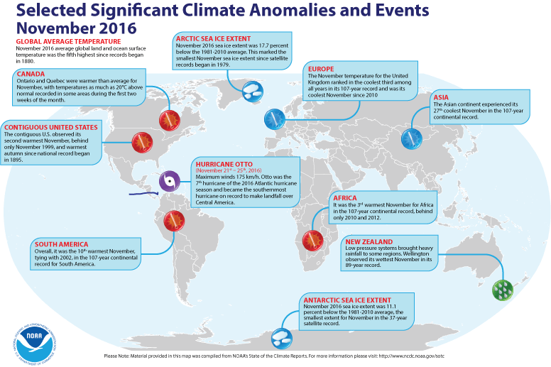
- A global review of November 2016 temperatures -- Preliminary
analysis of temperature data by scientists at NOAA's National Centers for Environmental Information (NCEI) indicates that the worldwide combined ocean and land
surface temperature for November 2016 was the fifth highest
global November surface temperature since a sufficiently dense and
reliable network began in 1880. This combined global temperature was approximately 0.73 Fahrenheit degrees above the 20th century (1901-2000) average November temperature. They also found that the global
ocean surface temperature was the second highest for any November since 1880, while the global land surface temperature was the twelfth highest temperature reading for any November on record.
In addition, the scientists reported that the seasonal global land and ocean temperature for the three-months of September through November was approximately 0.77 Celsius degrees above the 20th century average, making this three-month average the
second highest temperature departure from average on record. [NOAA/NCEI
State of the Climate]
A global map of Selected Significant Climate Anomalies and Events for November 2016 is available from NCEI.
According to satellite data collected by the National Snow and Ice Data Center, the sea ice over the Arctic Ocean during November 2016 had the smallest areal extent for any November since satellite-derived ice records began in 1979. In addition, the sea ice around Antarctica had the smallest November ice extent on record. The Northern Hemisphere snow cover extent was the fifth largest November snow cover in the 51-year period of record that began in 1966. [NOAA/NCEI Global Snow & Ice]
- UK Met Office global average temperature forecast made for 2017 -- During the last week, scientists at the United Kingdom's Meteorological Office (Met Office) released their annual global temperature forecast for the upcoming year of 2017. They anticipate the global average temperature in 2017 to be 0.44 Celsius degrees above the long-term (1981-2010) average of 14.3 degrees Celsius, with a range of uncertainty extending from 0.32 to 0.56 Celsius degrees around the central estimate. Therefore, 2017 could be a very warm year, but it would probably not be the record warmest year since comprehensive global climate records began in 1880, as a strong El Niño event was not anticipated during the year, which would create additional warming of the planet.
Using observational data running through October 2016, the scientists noted that this current year's global temperature was 0.86 Celsius degrees above the 1961-1990 average of 14.0 degrees Celsius, which compares favorably with the Met Office's forecast made last December that had a central estimate of 0.84 Celsius degrees. If this predicted temperature verified at the end of the year, 2016 would be the warmest year since 1880. [Editor's note: The statistics involved with the global temperature record are from the three main global temperature datasets compiled by: The Met Office and University of East Anglia (HadCRUT4); NOAA National Centers for Environmental Information (NOAA NCEI) and NASA Goddard Institute of Space Studies (NASA GISS). The Met Office still uses the 1961-1990 interval for long-term averages that is accepted by the World Meteorological Organization (WMO), rather than the 1981-2010 interval currently used by NCEI. EJH] [UK Met Office News]
- An All-Hazards Monitor -- This Web portal provides the user information from NOAA's National Weather Service, FAA and FEMA on
current environmental events that may pose as hazards such as tropical
weather, fire weather, marine weather, severe weather, drought and
floods. [NOAA/NWS Daily Briefing]
- Earthweek -- Diary of the Planet [earthweek.com]
Historical Events:
- 26-31 December 1993...The Sydney to Hobart Yacht Race off
Australia was plagued by hurricane-force wind gusts in excess of 74 mph
and 33 foot high seas. Of 104 starters, only 37 yachts finished the
race. On the 28th, one yacht owner spent five
hours in the water after being swept overboard. (Accord's Weather
Calendar)
- 26 December 2004...A massive earthquake measuring 9.0 on
the Richter magnitude scale approximately 100 miles off the western
coast of Sumatra created a tsunami that caused devastation in Sri
Lanka, India, Indonesia, Thailand, Malaysia, The Maldives and many
other areas around the rim of the Indian Ocean. The death toll is
currently estimated at more than 300,000. Officials say the true toll
may never be known, due to rapid burials. Indonesia was worst affected
with as many as 219,000 people killed. The total estimated material losses in the Indian Ocean region were $10 billion and insured losses were $2 billion. (Wikipedia) (National Weather Service files)
- 27 December 2001...Typhoon Vamei formed in the South China Sea, about 100 miles north of the Equator. Vamei was the first recorded tropical cyclone to develop within 1.5 degrees of latitude about 104 miles of the equator.(National Weather Service files)
- 28 December 1857...The light was first illuminated in the
Cape Flattery Lighthouse, located on Washington State's Tatoosh Island
at the entrance to the Strait of Juan de Fuca. "Because of Indian
trouble it was necessary to build a blockhouse on Tatoosh Island before
even commencing the construction of the lighthouse. Twenty muskets were
stored in the blockhouse, and then the lighthouse work began." (USCG
Historian's Office)
- 28 December 1903...An Executive Order extended the
jurisdiction of the Lighthouse Service to the non-contiguous territory
of the Hawaiian Islands. (USCG Historian's Office)
- 28 December 1908...An early morning earthquake under the
Straits of Messina leveled cities in Sicily and southern mainland
Italy, as well as producing a tsunami with 40-foot waves that inundated
coastal communities. This earthquake, estimated to by a magnitude 7.5
on the Richter scale, and the resulting tsunami killed an estimated
100,000 people. Long stretches of coastline sunk into the Messina
Straits and disappeared from view. A steady rain also added to the woes
of the survivors. (The History Channel)
- 29 December 1897...Congress prohibited the killing of fur
seals in the waters of the North Pacific Ocean. (US Coast Guard
Historian's Office)
- 30 December 1972...The 86-foot high wave measured by the
ship Weather Reporter was the world's highest
measured wave. The wave was measured in the North Atlantic Ocean at 59
degrees North latitude and 19 degrees West longitude. (Accord's Weather
Calendar)
- 30 December 1972...The 86-foot high wave measured by the
ship Weather Reporter was the world's highest
measured wave. The wave was measured in the North Atlantic Ocean at 59
degrees North latitude and 19 degrees West longitude. (Accord's Weather
Calendar)
- 1 January 1850...The lamp was lit at the first iron pile lighthouse in the U.S. built on Minot's Ledge, just outside the Boston (MA) Harbor. The Minot's Ledge Light, the first lighthouse in the U.S. to be exposed to the ocean's full fury, was swept away in a great gale on 16 April 1851. (Today in Science History)
- 1 January 1903...The first message telegraphed on the transpacific cable was sent from Honolulu, Hawaii to President Theodore Roosevelt in Washington, DC. The Cable Ship Silvertown began laying the 2620-mile long cable on 14 December 1902 when it left San Francisco, CA and it completed the project following its arrival at Oahu's Waikiki on 26 December. The cable now lies abandoned on the bottom of the Pacific after being abandoned in November 1951. (Today in Science History)
- 1 January 1954...The "Regulations for Preventing Collisions at Sea, 1948" commonly known as the "Revised International Rules of the Road" became law. These were a result of the International Conference on the Safety of Life at Sea, 1948. (US Coast Guard Historian's Office)
- 1 January 1958...The U.S. Coast Guard ceased listening continuously for distress calls on 2670 kilohertz. Although the countries of the world had agreed at the Atlantic City Convention of the International Telecommunication Union in 1947 to use 2182 kilohertz for international maritime mobile radiotelephone calling and distress, the U.S. Coast Guard had continued listening on the old frequency until the public had had sufficient time to change to the new one. (US Coast Guard Historian's Office)
- 1 January 1959...The U.S. Naval Observatory introduced the system of uniform atomic time using cesium beam atomic oscillators. This measurement has been adopted as standard by the International Committee on Weights and Measures. (Naval Historical Center)
- 1 January 1987...A winter storm brought rain, snow and high winds to the Southern and Middle Atlantic Coast Region. The storm, which occurred in a period of unusually high astronomical tides, produced a tide of 9.4 feet at Myrtle Beach, SC (their highest since Hurricane Hazel in 1954) which caused a total of 25 million dollars damage in South Carolina. (National Weather Summary) (Storm Data)
- 1 January 1997...Two 12-foot waves generated by an intense Pacific storm swept 27 people into the Pacific Ocean from the King Harbor Breakwater at Redondo Beach, CA. All survived the ordeal. (Accord's Weather Calendar)
Return to RealTime Ocean Portal
Prepared by DS Ocean Central Staff and Edward J. Hopkins,
Ph.D.,
email hopkins@aos.wisc.edu
© Copyright, 2016, The American Meteorological Society.