Date Due: Wednesday, 4 August 1999
The total maximum points were 200. Point distribution for each question is noted below.
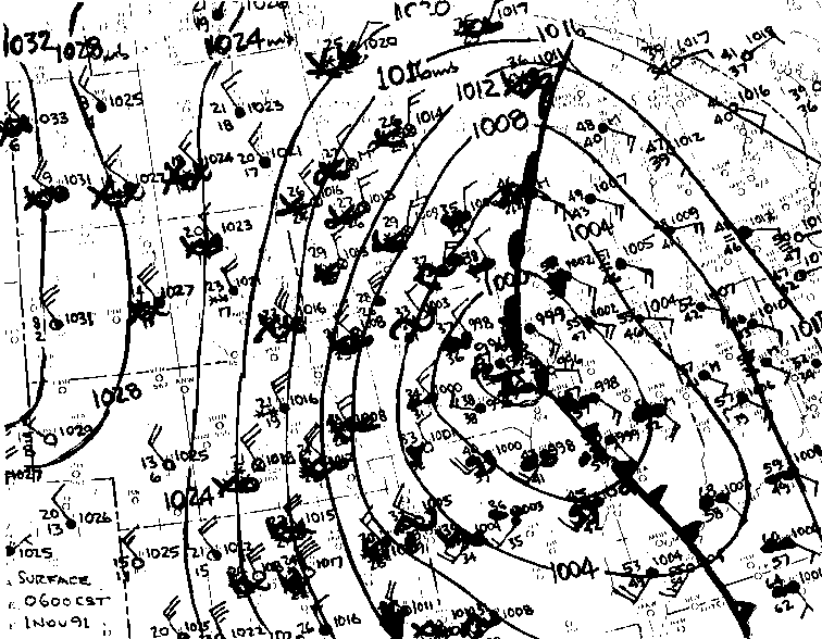
The attached map contains the surface weather features observed over the upper Midwest at 6:00 AM CST on Tuesday, 10 November 1998.
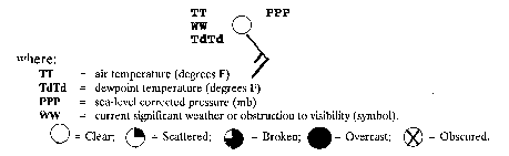
Wind arrows fly with the wind. Each full barb equals 10 knot wind speed. [Sample station reports a 15 knot wind from the southeast (SE)]. Missing values are indicated by an " M".
What were the conditions reported at Madison, WI at map time? (Include
units)
Temperature: Dewpoint: Pressure: Sky cover: Wind Speed: Wind Direction: Precipitation type or significant weather phenomenon: |
52 degrees F 50 degrees F 1002 mb Overcast (10/10 clouds) 15 knots Southeast Rain showers |
Points to consider during your isobar analysis:
1. Where is the low or high pressure center(s) located?
(Identify the pressure feature and state or province)
The surface low was in southeast Iowa, near Cedar Rapids. The surface high was in the Prairie Provinces - off the map |
The central pressure of the low over Iowa was approximately 995 mb. |
3. The isobars are usually spaced closer in regions where the wind speed is greatest.
4. Does your smoothed analysis conform to the above items ?
Yes it worked for me! |
Points to consider during your isotherm analysis:
1. Where are the warmest and coldest regions
(by state) found?
a. Warmest Southern Indiana, Illinois or central Kentucky and Tennessee. b. Coldest Nonwestern North Dakota, extending into Manitoba and Saskatchewan. |
Along the Mississippi River, extending from Eastern Iowa (near the low) to Missouri. |
1. Where are the regions of a) highest and b) lowest
dewpoints?
a) Highest (humid) Kentucky, Tennessee and southern Illinois b) Lowest (dry) Western South Dakota, into Wyoming and Montana |
a) Illinois Steady Rain b) Nebraska Steady Snow c) North central Iowa - Southeast Minnesota Freezing rain |
a) North Dakota = Northwest winds b) Central Illinois = Southeast winds |
Kansas (also Nebraska is acceptable) |
| Yes, they are closer in Kansas |
Illinois and South-central Wisconsin |
| Missouri and essentially most of states in region that are west of Mississippi River. |
1. A warm frontal passage in autumn resulting when an idealized cyclone passes from south to north, while staying west of you:
PRE-FRONTAL |
FRONTAL |
POST-FRONTAL |
CLOUDS (type) Cirrus/cirrostratus to altostratus to nimbostratus/stratus to fog to clear |
PRECIPITATION Steady rain to drizzle 'till frontal passage then none (type) |
TEMPERATURE (trend) Cool to Warm |
WINDS (direction) Northeast --->East -----> Southeast to south |
PRESSURE TENDENCY Falling Unsteady Steady to slow rise |
2. A cold frontal passage in the spring of the year when an idealized cyclone moving eastward passes from the northwest to the northeast of you:
PRE-FRONTAL |
FRONTAL |
POST-FRONTAL |
CLOUDS (type) Clear to Cumulus to Cumulonimbus to clear and stratocumulus |
PRECIPITATION Rain (snow) Showers Thunderstorms Snow (rain) showers (type) |
TEMPERATURE (trend) Warm to Cold |
WINDS (direction) South Southwest West Gusty Northwest |
PRESSURE TENDENCY Falling Unsteady Rapid rise |
3. The passage of an idealized snow producing cyclone (and attendant trough line) in winter traveling from southwest to northeast, but remaining just south of you:
BEFORE TROUGH |
TROUGH PASSAGE |
AFTER TROUGH |
CLOUDS (type) Cirrus/cirrostratus to altostratus to nimbostratus to stratocumulus |
PRECIPITATION light snow to heavy snow ---> decreasing to snowshowers (type) |
TEMPERATURE (trend) Cool -------> to ------> Cold |
WINDS (direction) Northeast -----> North ---------> Northwest |
PRESSURE TENDENCY Falling -----> steady -------> Rising |
URL Address: aos100/homework/99hmk04a.htm
|
|
|
|