WEEKLY CLIMATE NEWS
Thanksgiving Week: 24-28 November 2014
This is Thanksgiving Break for the Fall 2014 offering of the
DataStreme Earth Climate Systems course. This Weekly Climate News
contains new information items and historical data, but the Concept of
the Week is repeated from Week 11.
Have a happy and safe Thanksgiving Week from the AMS
DS ECS Central Staff and Ed Hopkins!
ITEMS
OF INTEREST
- End of a season -- With the end of
November on Sunday, 30 November 2014, the autumn meteorological season
in the Northern Hemisphere will end, followed by the start of the
meteorological winter season on Monday (1 December). Recall that
climatologists and meteorologists have elected to use a standard three-month grouping to
identify each meteorological season. Hence, September, October and
November are considered the autumn or fall meteorological season, while
the months of December, January and February are the winter season. You
will note that the winter solstice, marking the day where the length of
daylight is least in the Northern Hemisphere is still three weeks away,
falling on Sunday, 21 December 2014. Since the lowest temperatures
typically fall in mid to late January, the meteorological winter tends
to be centered on the coldest time of the year in the Northern
Hemisphere.
In addition, the end of November also marks the end of the official
hurricane seasons in the North Atlantic, which includes the Gulf of
Mexico and the Caribbean, along with the eastern and central North
Pacific basins.
- Watching the seasons -- phenology observations
and climate change -- For centuries, interested citizens and
scientists have been recording the dates of recurring biological and
other natural events that appear to be related to the seasons. This
tracking of these natural cyclic events, called phenology, if extended
over many years, can be used to document how long-term changes in these
seasonal events change in response to long-term changes in climate. For
more information on recent efforts to establish a nationwide
phenological observation network and how it could be used for studying
climate change, see this week's Supplemental
Information...In Greater Depth.
CURRENT
CLIMATE STATUS
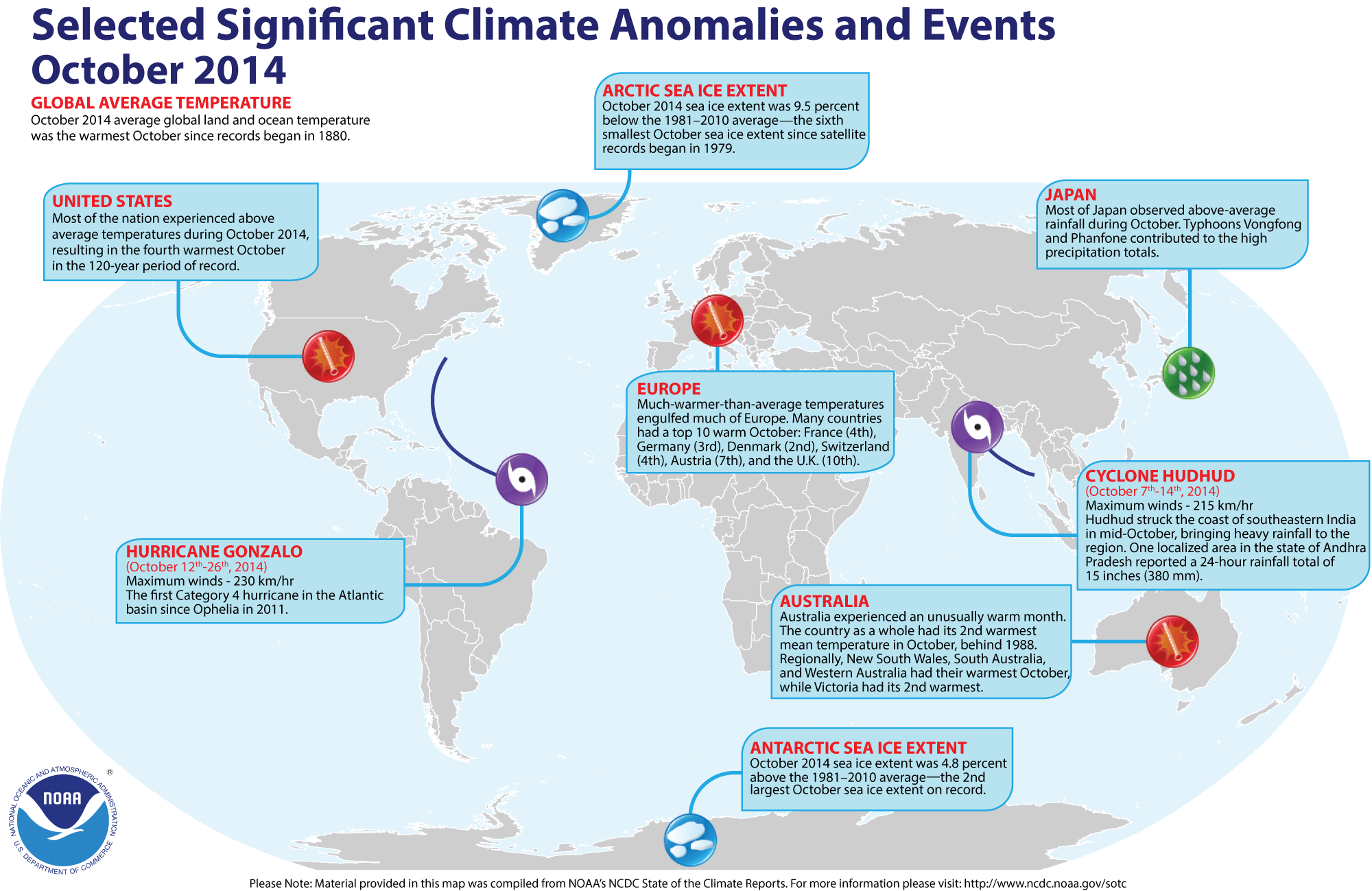
- Review of October 2014 global temperatures -- Preliminary data analyzed by scientists at NOAA's National Climatic Data Center indicated that the global combined land and ocean average surface temperature for the October 2014 was 1.33 Fahrenheit degrees above the 20th century average (1901-2000) for the month. Therefore, last month's global combined temperature was the record highest October temperature since global temperature records began in 1880. When considered separately, the monthly average temperature over the global oceans for October 2014 also was the highest October ocean temperature in 135 years. However, the monthly average temperature of the land surface for this recently concluded month was the fifth highest October land surface temperature on record. Curiously, the record high global sea surface temperature occurred in the absence of an El Niño event, a large-scale warming of the eastern and central equatorial Pacific Ocean.
Furthermore, when considering the combined land-ocean global temperature for the year to date (January-October 2014), the temperature was the highest ten-month global temperature since 1880. [NOAA/NCDC State of the Climate]
A global map of Selected Significant Climate Anomalies and Events for October 2014 is available from NCDC.
According to satellite data collected by National Snow and Ice Data Center, the sea ice over the Arctic Ocean during October 2014 had the sixth smallest areal extent for any October since satellite-derived ice records began in 1979. However, the sea ice around Antarctica was the second largest October ice extent on record. [NOAA/NCDC Global Snow & Ice]
CURRENT
CLIMATE MONITORING
- Link between wet soil and weather may be clarified by new satellite instrument-- Scientists and engineers at NASA's Jet Propulsion Laboratory are readying the agency's Soil Moisture Active Passive (SMAP) instrument that is scheduled to be launched in late January 2015 in an effort to determine how soil moisture influences weather, especially in those local agricultural areas considered to be "hot spots" including the US Midwest, northern India and the African Sahel. [NASA Earth Science News Team]
CLIMATE
AND THE BIOSPHERE
- Crops impact annual carbon dioxide cycle increase -- Researchers from six research universities in the US and Canada have found that the large rise in the productivity of crops grown for food over the last five decades has resulted in a significant increase in the seasonality of atmospheric carbon dioxide especially in the Northern Hemisphere. They estimate that 25 percent of the increase in the seasonal carbon dioxide cycle can be attributed to more intensive agricultural management. Furthermore, they claim that their findings could help improve climate models and provide a better understanding of the buffering capacity of ecosystems for atmospheric carbon dioxide. [University of Wisconsin-Madison News]
- Bleaching from warming oceans could impair long-term coral reproduction -- A biologist at Florida State University and colleagues with the Smithsonian have discovered that bleaching events caused by rising ocean temperatures appear to be having a detrimental long-term impact on coral by affecting the fertility of the coral. [Florida State University 24/7 News]
CLIMATE
FORCING
- Global warming may be slowed by small volcanic eruptions -- An international team of scientists report that relatively minor volcanic eruptions appear to have contributed to the recent slowdown in the increase in global temperatures over the last several decades. Using data collected from ground-, air- and satellite-instruments between 2000 and 2013, the researchers found that the aerosols produced by small volcanic eruptions reflected nearly double the amount of solar radiation as previously estimated. This reduction in the incident solar radiation could have been responsible for a decrease in global temperatures by 0.09 to 0.22 Fahrenheit degrees since 2001. [American Geophysical Union Newsroom]
- Salinity changes have a strong influence on regional sea level changes -- Scientists from Lawrence Livermore National Laboratory and Australia's Commonwealth Scientific and Industrial Research Organization (CSIRO) have found that long-term salinity changes appear to have a stronger influence on regional sea level changes than previously thought. They based their conclusions on ocean observations of temperature and salinity and large set of climate models. A long-term (1950-2008) pattern was found in halosteric (salinity-driven) sea level changes in the global ocean, with sea level increases occurring in the Pacific Ocean and sea level decreases in the Atlantic. [Lawrence Livermore National Laboratory News]
CLIMATE
FORECASTS
- Official updated winter weather outlook released -- Late last week,
forecasters at the NOAA Climate Prediction Center released their updated Three-Month Seasonal
Outlook for meteorological winter (the three months of December 2014 through
February 2015) across the nation. Specific details of their outlooks include:
- Temperature and precipitation outlooks -- According to their temperature outlook, the West Coast States along with most of the Intermountain West should experience a high chance of above average temperatures for these three upcoming months. The greatest probability of such an occurrence to be found across most of central and northern California, along with western sections of Oregon and Washington. In addition, northern New England centered upon Maine should have a good chance of a warmer than average winter. Conversely, south central and southeastern sections of the nation, extending from west Texas to Georgia's Atlantic coast were considered to have a better that average chance of below average winter temperatures. The outlook indicates that the remainder of the nation would have nearly equal chances of warmer or cooler than normal conditions. These regions would extend primarily across the northern Plains, the Midwest and the Middle Atlantic States.
Their precipitation outlook calls for sections of the interior Northwest and the Midwest centered upon Michigan and Indiana to have a better than even chance of below average precipitation for meteorological winter 2014-15.
On the other hand, the southern tier of states extending from southern California to the Florida Peninsula and the Atlantic Seaboard from Florida northward to southern New England would have better than even chances of above average rainfall totals for these three months. Elsewhere, a large area of the coterminous states should have essentially equal chances of below and above average precipitation for this upcoming winter.
A summary of the prognostic discussion of the 3-month outlook for non-technical users is available from CPC. These forecasts were based in part that assuming that the current ENSO-neutral conditions (ENSO = El Niño/Southern Oscillation), with neither prevailing El Niño nor La Niña conditions, should change to a weak El Niño event within the next several weeks. A description is also provided as how to read these 3-class, 3-month Outlook maps.
- Seasonal Drought Outlook -- The
forecasters at NOAA's Climate Prediction Center also released their US
Seasonal Drought Outlook last week that would run from late-November 2014 through February 2015.
Their outlook would call for persistence of extensive drought conditions across the Intermountain West, extending from the Great Basin of Utah and Nevada northward into interior Oregon and Washington. In addition, sections of the central and southern high Plains from the Panhandles of Texas and Oklahoma into southeastern Colorado and western Kansas should continue to experience drought conditions. However, most of California, the southwest and most of Texas could see some improvement of their drought conditions. Some areas across the interior Southwest and Texas could possibly be removed from drought status. Note: a Seasonal Drought Outlook Discussion is included describing the forecasters' confidence.
- Making projections of precipitation patterns across North America through the 21st century -- Maps made by the US National Climate Assessment, which was issued in May 2014, show projected seasonal precipitation changes across North America for the final decades of this century (2071-2099) compared to the end of the last century (1970-1999) based upon two possible scenarios for greenhouse gas emissions. In general, precipitation was projected to increase in the northernmost parts of the United States, but decrease across the southwestern United States. The amounts differ in terms of the emissions scenario selected, with large positive and negative changes both seasonally and geographically, occurring for the scenario where greenhouse gas emissions would continue increasing throughout the rest of century. The other scenario, which would assume that greenhouse gas emissions would peak during this current decade (2010 and 2020) and then rapidly decline afterward, would have smaller seasonal and spatial differences. [NOAA Climate.gov News]
CLIMATE
AND SOCIETY
- Helping build a resilient nation with a new online toolkit -- Early last week the Obama Administration launched the first phase of the US Climate Resilience Toolkit, a website developed by NOAA and other agencies designed to help state and local decision makers take action to boost the climate resilience of their communities using data-driven tools, information, and subject-matter expertise to make smarter decisions. This Toolkit is part of President Obama's Climate Action Plan. [NOAA News]
- Real-time ocean acidification data made available to Pacific coast shellfish growers -- NOAA's Ocean Acidification Program recently unveiled an online website called "the IOOS Pacific Region Ocean Acidification Data Portal" that provides fisheries interests with real-time, online ocean acidification data through the Integrated Ocean Observation System (IOOS). This website, which is the product of a NOAA-led national-regional partnership, will contain data ranging from carbon dioxide concentrations to salinity and water temperatures. Operators of shellfish farms and hatcheries along the Pacific US coast from California to Alaska would be some of the targeted user groups. [NOAA News]
- Earthweek -- Diary of the Planet [earthweek.com] Requires Adobe Acrobat Reader.

This Concept of the Week is repeated from Week 11.
Concept of the Week: Human health and
climate change
Climate scientists and other experts studying the projected
changes in the global climate have been concerned that these changes
can have potentially adverse effects upon human health. The specific
health outcomes are highly uncertain. However, according to the U.S.
Global Change Research Program's (USGCRP) Global
Climate Change Impacts in the United States Report,
several key health-related issues on the national level that could be
affected by climate are: heat issues and heat waves, air quality,
extreme weather events, heat associated diseases, pollen effects, and
vulnerable groups.
One of the more obvious consequences of changes in climate is
the increased incidence of temperature-related illnesses and deaths,
especially those that would occur with heat waves, or episodes of
extreme heat. Projected increases in air temperature and rising
humidity levels across the nation during the 21st century would also be
accompanied by increased frequency and intensity of heat waves, where
air temperature and heat indices would exceed certain threshold levels
for several days. In the United States, recent heat waves have resulted
in numerous deaths, especially in large metropolitan areas. The
elderly, the poor in urban areas and those with underlying health
issues (such as diabetes and hypertension) appear to be the most
susceptible to higher air temperatures and extended heat waves. Some
models indicate that mortality rates would increase more rapidly in
northern cities, where populations are less accustomed to the
less-frequent heat waves. Using a model that includes a high emissions
scenario, the average annual number of heat-related deaths in the
Chicago (IL) metropolitan area could reach 700 by 2050 and 1200 by 2100.
Exposure to air pollution that would include a variety of gas species
and particulate matter could result in health-related problems,
especially those people with respiratory and cardiovascular diseases.
Changes in climate could increase air pollutant exposure in several
ways. Large-scale atmospheric circulation patterns resulting in heat
waves are often stagnant, which reduce dispersion and create
environmental conditions for photochemical reactions that increases
ground-level ozone concentrations. Increased ozone has been shown to
cause reduction in lung function. These heat waves associated with
stagnant weather patterns would also increase fuel combustion for power
generation needed for air conditioning. Changes in climate could also
affect emissions of natural air pollutants and airborne allergens.
Certain health effects would be related to extreme weather
events. In addition to above-described heat waves, increases in
injuries and deaths could occur if extreme weather events such as
tropical cyclones (hurricanes or tropical storms) and floods would
increase in frequency. The disaster wrought by Hurricane Katrina on New
Orleans, LA and the Gulf Coast in 2005 could serve as an example.
Water-borne diseases can be related to water contamination caused by
heavy precipitation events. A Cryptosporidium outbreak in Milwaukee, WI occurred in 1993 in which 54 people died when
the municipal drinking water supply became contaminated by sewage that
was not properly treated because of overtaxed storm sewers. Some
climate models suggest an increased incidence of extreme weather events
across the nation during a warmer 21st century, especially in the
frequency of excessive precipitation events. If improvement in the
sewerage and water treatment facilities are not made, projected in
creases in intense precipitation events could pose an increased health
risk to many people, especially in the Northeast and Midwest. Chicago
could have sewer overflow events going up by 50 to 120 percent in the
future. In addition to the casualties that would be directly related to
the natural disasters, such as drowning, some secondary effects to
these disasters have been suggested, including problems with public
health infrastructures and with post traumatic stress disorder
following the event.
Increases in those infectious diseases borne by insects, ticks
and rodents could be possible with future changes in climate.
Temperature appears to serve as a major constraint on the range of
microbes and vectors, meaning that some diseases could be spread
poleward with higher temperatures. While malaria, yellow fever and
dengue fever have been nearly eradicated across the nation, some other
diseases, such as Lyme disease and encephalitis, transmitted between
humans by blood-feeding insects, ticks and mites, may occur in some
areas as the result of extended spells of warm wet winters, cold
springs. Rising temperatures and carbon dioxide concentrations appear
to increase pollen production and lengthen the pollen season.
Consequently, highly allergenic pollen could pose an increased health
risk to many people.
The report also cautions that particular groups of people
could be especially vulnerable to future climate change, highlighting
the increases in the incidence of diabetes and obesity, which make
individuals more susceptible to disease or air quality or heat.
While a range of negative health impacts would be possible from future
climate change, adaptation would likely help protect the majority of
the nation's population. This adaptation would entail maintenance of
the public health and community infrastructure across the nation.
Adequate water treatment systems would help curb waterborne diseases,
while health care facilities and emergency shelters would help minimize
the impacts of heat stress, air pollution, extreme
weather events, and diseases transmitted by insects, ticks, and
rodents.
Concept of the Week: Questions
(Place your responses on the Chapter Progress Response Form
provided in the Study Guide.)
- The number of deaths that could occur in a Chicago heat
wave by 2050 under the highest danger estimates could reach [(350),
(700), (1200)].
- The incidence of water and food borne diseases [(are),(are
not)] likely to increase.
Historical Events:
- 24 November 1950...The temperature at Chicago, IL dipped to
2 degrees below zero to equal their record for the month established on
the 29th in 1872. On the first of the month that
year, Chicago established a record high for November with a reading of
81 degrees. (The Weather Channel)
- 26 November 1896...Snow and high winds hit the Northern
Plains and the Upper Mississippi Valley, with a Thanksgiving Day
blizzard across North Dakota. The storm was followed by a severe cold
wave in the Upper Midwest. The temperature at Pokegama Dam plunged to
45 degrees below zero, which remains the lowest recorded November
temperature in Minnesota. (David Ludlum)
- 29 November 1975...Red River was buried under 34 inches of
snow in 24 hours, establishing a record for the state of New Mexico.
(The Weather Channel)
- 29 November 1985...The temperature at Bismarck, ND plunged
to 30 degrees below zero to establish their record low for the month of
November. The high that day was 4 degrees below zero. (The Weather
Channel)
- 29 November 1989...Sault Ste Marie, MI finished the month
of November with a record 46.8 inches of snow. (The National Weather
Summary) (Storm Data)
- 30 November 1976...MacLeod Harbor, AK reported a
precipitation total for November of 70.99 inches, which established a
state record for any month of the year. (The National Weather Summary)
- 30 November 1991...Minneapolis, MN ended the month with
46.9 inches of snow, the most ever for November and for any month.
Although the official start of winter was still 3 weeks away, the city
had already surpassed the normal seasonal snowfall record with 55.1
inches since 1 October (normal for the entire winter is 49.2 inches).
(Intellicast)
Return to DataStreme
ECS website
Prepared by Edward J. Hopkins, Ph.D., email hopkins@meteor.wisc.edu
© Copyright, 2014, The American Meteorological Society.