WEEKLY CLIMATE NEWS
29 October - 2 November 2018
ITEMS
OF INTEREST
- Worldwide GLOBE at Night 2018 Campaign for November commences -- The eleventh in a series of GLOBE at Night citizen-science campaigns for 2018 will commence this Tuesday (30 October) and continue through Thursday, 8 November. GLOBE at Night is a worldwide, hands-on science and education program designed to encourage citizen-scientists worldwide to record the brightness of their night sky by matching the appearance of a constellation with the seven magnitude/star charts of progressively fainter stars. These constellations are Perseus in the Northern Hemisphere and Grus for the Southern Hemisphere. Activity guides are also available. The GLOBE at night program is intended to raise public awareness of the impact of light pollution. The twelfth and last series in the 2018 campaign is scheduled for 29 November-8 December 2018. [GLOBE at Night]
- November weather calendar for a city near you -- The Midwestern Regional Climate Center maintains an interactive website that permits the public to produce a ready to print weather calendar for any given month of the year, such as November, at any of approximately 270 weather stations around the nation. (These stations are NOAA's ThreadEx stations.) The entries for each day of the month includes: Normal maximum temperature, normal minimum temperature, normal daily heating and cooling degree days, normal daily precipitation, record maximum temperature, record minimum temperature, and record daily precipitation; the current normals for 1981-2010.
- Time change does not affect climate records -- Daylight
Saving Time ends this coming Sunday morning (4 November) across essentially
the entire nation -- the exceptions include Arizona, Hawaii, Puerto
Rico and about 18 counties in Indiana. These changes have been mandated
by the U.S. Congress in the Energy Policy Act of 2005, which extended
Daylight Saving Time across the nation, with the start on the second Sunday in March (10 March 2019) and end on the first Sunday in November (3 November 2019). (Additional information is available from the National Institute of Standards and Technology.)
Most of Canada also observes changes to Daylight
Saving Time at the same time [National
Research Council Canada]. In other words, following the old
adage of "spring ahead, fall behind", you will need to turn your clocks
ahead by one hour to conform with the local time observance.
What does this time change mean to you (other than earlier sunsets)?
Contrary to a popular belief that has surfaced at times, the change
from Standard to Daylight Saving Time does not add an extra hour of
daylight to the day nor does it affect climate record keeping. The
daily high and low temperatures, along with the 24-hour precipitation
taken by essentially all stations across the nation are based upon
local Standard time, not Daylight time. Therefore, the daily entries in
the Preliminary Local Climate Data (CF6) for any of the more than 200
cities around the nation will remain on Standard time throughout the
year. The daily climate data collected at those automatic weather
stations operated by the National Weather Service and the Federal
Aviation Administration, together with all the cooperative weather
observing stations around the nation are always made according to local
standard time. NOTE: You may check the correct current official time at http://www.time.gov/.
- Exploring ENSO patterns on a global scale -- An activity was created by a geology professor at Earlham College that allows high school and college students who have become familiar with ENSO (El Niño-Southern Oscillation) to explore the reality of ocean surface temperature (SST) data. Students analyze a time series of SST anomaly maps for a 14-year interval to create an ENSO timeline. [NOAA Climate.gov Teaching]
- Reconstructing past climates -- Scientists
from many disciplines have developed a variety of methods that use
proxy indicators such as tree rings, ice cores and ocean cores to
reconstruct past climates, some extending back thousands of years. For
more details on paleoclimatology, or the study of past climates, and
available data sets, please read this week's Supplemental
Information...In Greater Depth.
CURRENT
CLIMATE STATUS
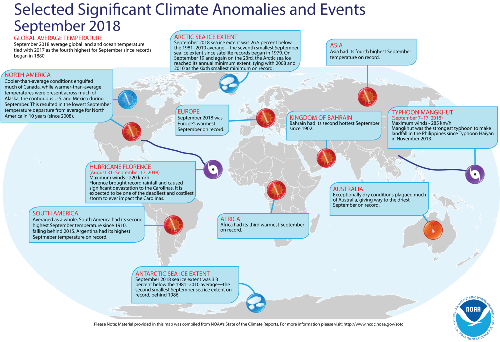
- September 2018 weather and climate for the globe reviewed -- Scientists at the NOAA National Centers for Environmental Information (NCEI)
recently reported on their analysis of preliminary weather data collected from around the world during the month of September 2018. They found:
- The global combined land and ocean average surface temperature for September 2018 was 1.40 Fahrenheit degrees above the 59.0 Fahrenheit degrees, which is the 20th-century average (1901-2000) for the month. Consequently, the September 2018 global September temperature essentially ties that for one year ago (September 2017) as being the fourth warmest September since a sufficiently dense network of global temperature records began in 1880. The warmest September on record was in 2015, which had a temperature departure of +0.93 Fahrenheit degrees above the 20th century average.
When considered separately, the land surface temperature for this recently concluded month was the sixth highest September temperature in the 139-year record, with a monthly temperature that was approximately 1.84 Fahrenheit degrees above the 20th-century average. For comparison, the September record for air temperatures over land was set in September 2016, which had a temperature departure from the 20th century average of +2.23 Fahrenheit degrees.
Over the oceans, the September 2018 globally-averaged sea surface temperature was 1.24 Fahrenheit degrees above the 20th century average, which was the fourth highest temperature on record for the month. The air over the oceans was the warmest in September 2015, with a temperature departure of +1.49 Fahrenheit degrees.
- According to data provided by the National Snow and Ice Data Center (NSIDC), the September Arctic sea ice extent in the Northern Hemisphere was approximately 26.5 percent below the 1981-2010 average, which tied September 2008 as the sixth smallest September Arctic sea ice extent since satellite records began in 1979. In the Southern Hemisphere, the September 2018 Antarctic sea ice extent was the second smallest September extent in the 40-year record.
- A global map of Selected Significant Climate Anomalies and Events for September 2018 is available from NCEI.
- A summary article on the September global climate highlights is available, while more detailed analysis with tables and maps can be viewed. [NOAA/NCEI State of the Climate]
CURRENT
CLIMATE MONITORING
- The Climate Explorer tool is available to help envision climate projections for climate adaptation -- An expanded and enhanced version of the research application tool entitled The Climate Explorer has been made available to the public that allows users to envision a range of potential future weather and tidal conditions, so they can consider and implement climate-smart adaptation strategies. The Climate Explorer, which is an integral part of the U.S. Climate Resilience Toolkit, provides historical observations and projections for climate variables for any county in the contiguous United States through 2100 in interactive graphical and map formats. [U.S. Climate Resilience Toolkit]
- NOAA's GOES-17 satellite to be moved to its operational position as GOES-West -- Last Wednesday, engineers began moving NOAA's newest Geostationary Operational Environmental Satellite (GOES)-17 satellite westward from the position that it has occupied for the last seven months to position where it will become GOES-West. Following launch last March, the satellite was placed in a geosynchronous orbit of Earth (at an altitude of 22,240 miles), positioned above the Equator and at a longitude close to the 90th West meridian for testing of its onboard equipment. The current maneuver or "drift," which should be completed by 13 November, is to a position over the Equator at a longitude of 137.2 degrees West. In this position, GOES-17 will become GOES-West, providing a high-resolution view of weather systems across western North America (including southern Alaska), Hawaii and much of the Pacific Ocean. [NOAA National Environmental Satellite, Data, and Information Service News]
- Planning advances for nation's newest space weather satellite mission -- NASA Goddard Space Flight Center issued a request last week to commercial vendors for information about some of the instruments that would be needed for NOAA's Space Weather Follow-on Mission (SWFO-L1). The desired information involves knowledge about the latest satellite technologies capable of monitoring space weather, which involves the impact that the solar wind and solar storms have upon Earth's environment. The SWFO-L1 mission, which is scheduled for launch in 2022, would complement and extend measurements from NOAA's Deep Space Climate Observatory (DSCOVR) satellite at Lagrange point 1 that was launched in 2015. [NOAA National Environmental Satellite, Data, and Information Service News]
- Investigating winter weather across U.S. during each El Niño winter since 1950 -- Two blogs were recently posted on the ClimateWatch Magazine that contain maps of average temperatures and precipitation across the 48 contiguous states for meteorological winter (December through February) during each of the 24 El Niño winters that have been identified since 1950. These winters that coincided with an El Niño have been ranked as being: strong (2015-16, 1982-83, 1997-98, 1957-58); moderate (1972-73, 1991-92, 2009-10, 1965-66, 1986-87, 1963-64, 1968-69, 1994-95) and weak (2002-03, 1953-54, 1987-88, 1976-77, 1977-78, 2006-07, 1958-59, 1979-80, 2004-05, 2014-15, 1951-52, 1969-70). The strength of the El Niño was based upon the Oceanic Niño Index (ONI). The variability from one El Niño to the next reveals a certain degree of uncertainty as to its effect upon seasonal climate.
- The maps for winter (DJF) precipitation during El Niño winters show a tendency for wetter than average conditions across the South, especially during moderate and strong El Niño winters. Wetter than average winters could be found along the Pacific Coast during a few strong and weak El Niño events. [NOAA Climate.gov News]
- The maps for winter temperature during an El Niño winter shows that the influence of El Niño upon temperature is less reliable than its influence on precipitation. The strongest El Niño events have resulted in unseasonably mild winters across most of the contiguous U.S., while cooler than average winters have been found across the South and East during some moderate and weak events. [NOAA Climate.gov News]
Note: Earlier this autumn, a blog posted to the site featured a summary of snowfall during El Niño winters between 1950 and 2009. [NOAA Climate.gov News]
PALEOCLIMATE RECONSTRUCTIONS
- Unearthing ice age climate clues -- A scientist at Rice University and her colleagues at other research institutions have created a proxy system modeling (PSM) technique that can be used in paleoclimatology to improve the interpretation of paleoclimate data. Their package of comprehensive and consistently formatted computational models is called PRYSM, where information collected from water-isotope based climate proxies (ice cores, corals, tree ring cellulose, and speleothem calcite) can be used to translate data in a way that relates more directly to measurable climate model variables. conventions. PRYSM is a modeling toolbox that is publicly available and facilitates proxy-climate (simulated or historical) comparisons. [Rice University News]
CLIMATE
AND SOCIETY
Concept of the Week: Extending the
Historical North American Drought Record
Through history, drought has been a major concern for many
people as the lack of adequate water can adversely affect agriculture,
and in the extreme case, the availability of potable (drinkable) water.
The Case in Point for Chapter 9 describes the migration of ancient
peoples across the semiarid Southwest due to what may have been major
drought conditions. During the last century, the "Dust Bowl" era
drought in the 1930s created many problems in this country. The effects
of this seven-year long drought were made worse by poor agricultural
techniques and land management. The effect of the drought on the nation
was also exacerbated by the coincident Great Depression. Drought
remains a problem today across Texas and the West Coast as we can see
from inspection of the current weekly US National Drought Monitor
produced by the National Drought Mitigation Center.
How do the current drought events compare with earlier
droughts? A time series of computed Palmer Drought Severity Index
(PDSI) values began in 1895 when a sufficiently dense climate network
was established. During the 20th century, several episodes of drought
have had a major national impact. The exceptional drought that
developed in the early 1930s extended across much of the nation
resulting in the "Dust Bowl" era. The PDSI time series shows that the
1930s drought was the worst in the last century, with nearly 80 percent
of the nation experiencing moderate to extreme drought in 1934. During
the 1950s, the southern Plains and the Southwest also experienced a
major drought, when 50 to 60 percent of the nation was under drought
conditions.
What about farther back in history? Sophisticated tree-ring
analysis techniques allow researchers to extend the drought record
across a large section of North America farther into the past. In 1998,
Edward R. Cook at Columbia University's Lamont-Doherty Earth
Observatory along with colleagues at Arizona and Arkansas reconstructed
past drought conditions across the nation based upon annual tree-ring
data obtained from a network of 388 climatically sensitive tree-ring
sites. From these data, time series of annual summertime (June-August)
PDSI values were determined back to 1700 at 155 grid points across the
nation. These gridded tree-ring chronologies were calibrated with PDSI
chronologies generated by instrumental records at selected Historical
Climate Network stations commencing in the late 19th century. The
researchers found that the 1930s drought was the most severe drought to
hit the nation since 1700.
By 2004, the series was expanded to 835 tree-ring sites,
primarily across the West, where exactly dated annual tree-ring
chronologies were obtained. The new grid covered most of North America
with a latitude-longitude spacing of 2.5 degrees. In addition to the
286-grid point PDSI time series, annual contour maps of PDSI were
constructed that span much of the continent. This work permitted
extension of the spatial and temporal coverage of the drought
reconstruction not only into Canada and Mexico, but back 2000 years.
From this more recent data set they produced an online "North American
Drought Atlas." They found several "megadroughts" in North America were
even more severe than the 1930s drought. In addition to being more
severe, some droughts extended over several decades, considerably
longer than those of the 20th century. One such megadrought was in the
16th century, an event that along with another megadrought into the
early 17th century has been implicated by some researchers in the
hardships encountered by British settlers in the Virginia area, such as
the disappearance of the Roanoke Colony.
Historical Events:
- 29 October 1917...The temperature at Soda Butte, WY the
mercury plunged to 33 degrees below zero, an U.S. record for the month
of October. (David Ludlum)
- 29 October 1991...Bismarck, ND received 15.9 inches of snow
on the 28th and 29th.
This brought the October snowfall total to 23.5 inches, a new record.
(Intellicast)
- 30 October 1925...Nashville, TN was blanketed with an inch
of snow, their earliest measurable snow of record. (The Weather
Channel)
- 31 October 1987...Yakima, WA reported measurable rainfall
for the first time since 18 July. The 103-day long dry spell was their
longest of record. (The National Weather Summary) (Storm Data)
- 31 October 1991...A severe winter storm dubbed the "Great
Halloween Mega Storm" struck the upper Midwest. Minnesota bore the
brunt of the storm. By the time the storm finally ended on 2 November,
Duluth received 37 inches of snow and Minneapolis 28 inches, which were
new all time records for single storm totals. These two cities received
nearly half their normal seasonal snows in this one storm. In
Wisconsin, 35 inches of snow was reported at Superior and 30 inches at
Iron River. (Intellicast)
- 31 October 1993...Corpus Christi, TX dropped to 28 degrees
to set the October (and November) record. Brownsville dropped to a
monthly record 35 degrees. (Intellicast)
- 2 November 1946...A heavy wet snow began to cover the
Southern Rockies. Up to three feet of snow blanketed the mountains of
New Mexico, and a three-day snowstorm began at Denver, CO. By the time
it ended, this storm had dropped 31 inches, making it the second
greatest snowfall ever in city history and causing roofs to collapse.
(David Ludlum)
- 2 November 1961...The temperature at Atlanta, GA reached 84
degrees to establish a record for November. (The Weather Channel)
- 2 November 1966...A storm brought 18 inches of snow to
Celia, KY in 24 hours. It tied the state 24-hour snowfall record first
established at Bowling Green. (The Weather Channel)
- 2 November 1988...A very intense low pressure system
brought heavy rain, snow, and high winds, to parts of the northeastern
U.S. Portland, ME established a record for November with 4.52 inches of
rain in 24 hours, and winds along the coast of Maine gusted to 74 mph
at Southwest Harbor. (The National Weather Summary) (Storm Data)
- 3 November 1890...The temperature at Los Angeles, CA
reached 96 degrees, a November record for 76 years. (David Ludlum)
- 3 November 1927...The "Great Vermont Flood" began as a
two-day rain of up to 9 inches put rivers in western New England over
their banks. Somerset, VT was deluged with 8.77 inches of rain to
establish a 24-hour record for the state. (3rd-4th)
(The Weather Channel) (Intellicast)
- 3 November 1989...Cold weather prevailed in the central
U.S. The low of 7 above zero at Marquette, MI was their lowest reading
of record for so early in the season. (The National Weather Summary)
- 4 November 1983...The temperature at Billings, MT soared to
77 degrees, a new record for the data and month. (Intellicast)
- 4-5 November 1966...The River Arno surged above flood stage
and caused irreparable damage to much of the architectural and art
treasure of Florence, Italy. Millions of historical library volumes
were either damaged or destroyed. More than 15,000 vehicles were also
destroyed. Roughly two-thirds of Florence was flooded, 113 people died
and 30,000 were made homeless by the flooding on both the Arno and Po
rivers. (Accord Weather Calendar) (Wikipedia)
Return to RealTime Climate Portal
Prepared by Edward J. Hopkins, Ph.D., email hopkins@aos.wisc.edu
© Copyright, 2018, The American Meteorological Society.