If we want to see what the current weather is like across the country or what weather that could be expected over the next day or two, we would consult the daily weather maps and the forecast charts. We would soon realize that tranquil weather is usually associated with areas of high pressure on the surface weather maps, while inclement weather typically accompanies low-pressure systems. Weather forecasts for the next several days are based upon numerical prediction models, such as those run at NOAA's Hydrometeorological Prediction Center. These models are predicated on sophisticated numerical weather prediction models that have a set of equations including those describing Newtonian motion, thermodynamics and mass conservation. Observational data from the surface and aloft describing current weather conditions are entered into these weather prediction models, and iterative calculations are made of the atmospheric state at computational small time-steps over the next several days. Output statistics are generated by these models for the next 60 hours (short-range forecasts) and the next 10 days (medium-range forecasts).
To determine what type of weather conditions that we could expect for the next month or the next season (typically a three-month span) would require consultation with the official climate outlook maps generated by NOAA's Climate Prediction Center (CPC). These maps show the probabilities of how the temperature, precipitation and sea surface temperatures (SSTs) will deviate from the long-term or normal state for the next month and three month periods, extending from one to thirteen months into the future. In addition to these one-month to three-month climate outlooks, CPC also issues 6-10 Day and 8-14 Day extended outlook maps. These maps also show the probabilities of temperature and precipitation departing from the long-term average or normal conditions. The long-lead forecasts that may range from two weeks to thirteen months are based upon a dynamical ocean-atmosphere model that incorporates oceanic and atmospheric data. Sophisticated statistical analysis predicts how the patterns of temperature and precipitation should evolve based upon recent patterns of temperature and precipitation across the national, along with global sea-surface temperatures and tropospheric flow patterns. Consideration is also made of the effects of trends associated with El Niño and La Niña effects (to be discussed next week).
http://www.cpc.ncep.noaa.gov/products/precip/CWlink/MJO/enso.shtml#composite.
OCN - THE OPTIMAL CLIMATE NORMALS METHOD PREDICTS T AND P ON THE BASIS OF
YEAR-TO-YEAR PERSISTENCE OF THE OBSERVED AVERAGE ANOMALIES FOR A GIVEN SEASON
DURING THE LAST 10 YEARS FOR T - AND THE LAST 15 YEARS FOR P. OCN EMPHASIZES
LONG-TERM TRENDS AND MULTI-YEAR REGIME EFFECTS. OCN FORECASTS ARE AVAILABLE FOR
ALL 13 FORECAST PERIODS - BUT ARE NOT YET AVAILABLE FOR HAWAII OR FOR ALASKAN
PRECIPITATION.
CAS - CONSTRUCTED ANALOG ON SOIL MOISTURE IS BASED ON EMPIRICAL ORTHOGONAL
FUNCTIONS (EOF) FROM DATA OVER THE LOWER 48 STATES BEGINNING IN 1932. THIS TOOL
CONSTRUCTS A SOIL MOISTURE ANALOG FROM A WEIGHTED MEAN OF PAST YEARS. THE
WEIGHTS ARE DETERMINED FROM THE SIMILARITY OF SOIL MOISTURE CONDITIONS IN PRIOR
YEARS TO A COMBINATION OF RECENTLY SOIL MOISTURE OBSERVATIONS AND A MEDIUM RANGE
FORECAST OF SOIL MOISTURE OUT TO 14 DAYS BASED ON MRF TEMPERATURE AND
PRECIPITATION FORECASTS. THEN THE TEMPERATURE AND PRECIPITATION OBSERVED IN
SUBSEQUENT SEASONS IN THOSE PAST YEARS ARE WEIGHTED IN THE SAME PROPORTION TO
PRODUCE A FORECAST THAT IS CONSISTENT WITH CURRENT SOIL MOISTURE CONDITIONS.
ALTHOUGH AVAILABLE THROUGHOUT THE YEAR - THE CAS IS USED ONLY DURING THE WARM
HALF OF THE YEAR FROM APRIL TO SEPTEMBER AND FOR THE SHORTER LEADS WHEN THEIR
EFFECTS ARE THE MOST PRONOUNCED AND SKILLFUL.
SMLR - SCREENING MULTIPLE LINEAR REGRESSION TOOL IS USED TO EXTRACT INFORMATION
FROM A VARIETY OF SOURCES TO PRODUCE A FORECAST FOR SEASONAL AND MONTHLY
TEMPERATURE AND PRECIPITATION. SMLR USES THE SAME PREDICTOR FIELDS AS FOR CCA
BUT IS APPLIED TO SINGLE STATIONS RATHER THAN MULTI-STATION ANOMALY PATTERNS AS
IS DONE IN CCA. ADDITIONALLY - SMLR USES THE TWO WEEK MRF-BASED SOIL MOISTURE
FORECAST AS A PREDICTOR.
FORECAST SKILL:
PREDICTIVE ACCURACY IN THE LOWER 48 STATES FOR TEMPERATURE PEAKS IN THE LATE
WINTER WITH A SECONDARY PEAK IN THE LATE SUMMER - AND IS LOWEST IN THE LATE
SPRING AND LATE FALL. ALASKAN TEMPERATURE SKILL IS HIGHEST IN THE EARLY WINTER
AND ALSO GOOD IN EARLY SUMMER AND IS LOWEST IN EARLY FALL FOR CCA.
FOR ALL MODELS PRECIPITATION FORECASTS ARE GENERALLY LESS SKILLFUL THAN
TEMPERATURE -- WITH MARGINAL SKILL FOR ALL TOOLS EVEN IN THEIR BEST SEASONS AND
LOCATIONS UNDER NORMAL CIRCUMSTANCES. HOWEVER WHEN STRONG EL NINO OR LA NINA
CONDITIONS ARE PRESENT - PRECIPITATION SKILL CAN BE AS HIGH AS TEMPERATURE SKILL
FOR COOL SEASON FORECASTS FOR A NUMBER OF AREAS OF THE U.S. - INCLUDING THE
SOUTHERN THIRD - THE NORTHERN ROCKIES - THE HIGH PLAINS AND THE OHIO VALLEY.
STRONG LA NINA CONDITIONS IMPLY THE POSSIBILITY OF MODERATE PRECIPITATION SKILL
FOR SOME PARTS OF THE WARM SEASON AS WELL.
24 YEARS OF HINDCASTS ARE RUN EACH MONTH FOR USE IN DEFINING THE CLIMATOLOGY AND
SKILL CHARACTERISTICS OF THE CFS. A SKILL MASK IS CONSTRUCTED FROM THIS DATA
AND MASKED FORECASTS ARE PROVIDED TO THE FORECASTER.
SKILL OF CFS NINO 3.4 FORECASTS EQUALS OR EXCEEDS THAT OF THE STATISTICAL
FORECAST MODELS AT LEADS OUT TO NINE MONTHS.
THE CONSTRUCTED ANALOG FORECAST FROM SOIL MOISTURE (CAS) GIVES HIGHEST SKILL FOR
TEMPERATURE FROM APRIL THROUGH SEPTEMBER - WITH PEAK SKILL IN EARLY SUMMER. THE
MOST SKILLFUL SEASONS FOR PRECIPITATION FORECASTS ARE SON THROUGH JFM FOR OCN
PREDICTIONS - AND THE LATE WINTER FOR THE OTHER TOOLS. ALASKAN SKILL PEAKS IN
THE LATE FALL FOR BOTH CCA AND THE CMP.
THE SCREENING MULTIPLE LINEAR REGRESSION (SMLR) TOOL HAS SKILL CHARACTERISTICS
SOMEWHAT SIMILAR TO CCA - BUT SINCE IT IS DESIGNED TO PREDICT FOR INDIVIDUAL
STATIONS AND REGIONAL CLIMATE DIVISIONS IT MAY DO BETTER THAN CCA IN SMALLER
REGIONS HAVING UNIQUE RELATIONSHIPS SUCH AS THOSE CAUSED BY LOCAL TERRAIN -
ADJACENT WATER BODIES - OR DEVELOPING URBAN HEAT ISLANDS.
FORECAST FORMAT:
FORECASTS ARE EXPRESSED AS THE PROBABILITY ANOMALY OF THE OBSERVATION OF MEAN
TEMPERATURE (TOTAL PRECIPITATION) FALLING INTO THE MOST LIKELY OF THREE CLASSES
- EITHER ABOVE - NEAR - OR BELOW NORMAL (MEDIAN). CLASSES ARE DEFINED BY LIMITS
THAT DIVIDE THE 1971-2000 CLIMATOLOGICAL DISTRIBUTION INTO THIRDS. THUS EACH
CLASS HAS A CLIMATOLOGICAL CHANCE OF OCCURANCE OF 33.3%. THE FORECAST
PROBABILITY ANOMALY IS THE DIFFERENCE BETWEEN THE ACTUAL FORECAST PROBABILITY OF
THE VERIFYING OBSERVATION FALLING IN A GIVEN CATEGORY AND ITS CLIMATOLOGICAL
VALUE OF 33.3% PROBABILITY ANOMALY CONTOURS ARE DRAWN AT 10% ANOMALY INTERVALS
WITH A SUPPLEMENTAL CONTOUR AT 5% TO HELP DEFINE THE AREAS OF ONLY WEAK SIGNAL.
A FORECAST PROBABILITY ANOMALY OF EITHER ABOVE OR BELOW NORMAL IN THE THREE-
CLASS SYSTEM IMPLIES A CORRESPONDING REDUCTION IN THE PROBABILITY OF THE
OPPOSITE CLASS AND A FIXED PROBABILITY (AT 33.3%) OF THE NEAR NORMAL CLASS FOR
PROBABILITY ANOMALIES UP TO 30%. FOR PROBABILITY ANOMALIES GREATER THAN 30% OF
ABOVE OR BELOW NORMAL THE PROBABILITY OF THE OPPOSITE CLASS IS FIXED AT 3.3%
(A -30% ANOMALY) AND THE PROBABILITY OF THE NEAR NORMAL CLASS IS REDUCED BY THE
EXCESS FORECAST PROBABILITY ANOMALY OVER 30%. NOTE THAT THIS IS ONLY A CRUDE
APPROXIMATION OF THE TRUE PROBABILITY OF THE NON-SPECIFIED CLASSES AND IS
GENERALLY LESS ACCURATE FOR EXTREME SHIFTS (20% OR MORE) IN THE PROBABILITY
ANOMALY OF THE MOST LIKELY CLASS.
EXAMPLES: FORECAST PROBABILITY ANOMALIES OF 20%, 30% AND 40% FOR ABOVE NORMAL
IMPLY PROBABILITIES FOR ALL THREE CLASSES (ABOVE - NEAR - BELOW) OF 53.3% - 33.3%
- 13.3% --- 63.3% - 33.3% - 3.3% AND 73.3% - 23.3% - 3.3% RESPECTIVELY.
OCCASIONALLY THE FORECAST CALLS FOR AN INCREASED CHANCE OF THE OBSERVATION
FALLING IN THE MIDDLE CLASS. WHEN THIS OCCURS - HALF OF THE INCREASED
PROBABILITY OF THE MIDDLE CLASS IS SUBTRACTED FROM EACH OF THE EXTREMES.
FOR USERS WHO PREFER A 2-CLASS SYSTEM TO THE CURRENT 3-CLASS SYSTEM - CONVERSION
TO A 2-CLASS SYSTEM CAN BE DONE VERY SIMPLY BY ALTERING 50-50 CLIMATOLOGICAL
PROBABILITIES FOR THE BELOW VERSUS ABOVE NORMAL TWO CLASS CATEGORIES BY THE
PROBABILITY ANOMALY SEEN ON OUR MAPS. FOR EXAMPLE -- A 20% ANOMALY TOWARD ABOVE
NORMAL W0ULD CONVERT TO AN 70% CHANCE FOR ABOVE AND A 30% CHANCE FOR BELOW IN A
2-CLASS SYSTEM - A 30% ANOMALY TO 80 AND 20% - AND A 40% TO 85 AND 15%.
FUTURE REVISIONS OF THIS MESSAGE WILL BE ISSUED WHENEVER SIGNIFICANT CHANGES IN
THE AVAILABLE FORECAST TOOLS ARE MADE.
NNNN
NNNN
http://www.cpc.ncep.noaa.gov/products/forecasts/
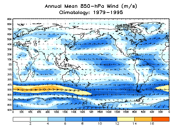
Since the atmosphere is a three-dimensional entity, we need to inspect the long-term planetary-scale atmospheric circulation regime at several levels in the troposphere above the earth's surface. We will consider climatological maps depicting the monthly wind fields generated by NOAA's Climate Prediction Center (CPC) from upper air data collected from 1979 through 1995. CPC has generated these climatological data sets (that appear at http://www.cpc.ncep.noaa.gov/products/precip/CWlink/climatology/ ) for analysis of monthly upper air conditions and the preparation of monthly and seasonal outlooks.
The suite of upper air maps that CPC has produced is based data collected, analyzed and displayed at constant pressure levels, rather than at constant altitude levels. Specifically, the monthly mean flow is displayed for the lower troposphere at the 850-hectaPascal (hPa) or (mb) constant pressure level and for the upper troposphere at the 200-hPa constant pressure level. These upper air maps have wind arrows plotted at grid points spaced at 10-degree latitude and longitude intervals following spatial interpolation of the observational data collected by radiosondes. The direction of these arrows shows direction of the wind flow at each grid point, while the lengths of these arrows provide an indication of the wind speed. Color coded bands of isotachs (lines connecting equal values of wind speed) are also indicated with the legend below the maps. The units for wind speed are meters per second (1 m/s = 2.27 mph).
LOWER TROPOSPHERIC FLOW
The CPC climatology charts for the lower troposphere have been selected on the 850-mb (or hPa) constant pressure level, which is approximately at an altitude of 5000 feet above sea level. For many areas, especially across the tropics, this level is at or slightly above the friction level, meaning that the effects of friction from the surface have been minimized. However, this pressure surface is below the higher terrain of the western Cordillera of both North and South America, along with the Himalayan Massif in Asia.
The mean annual flow at 850 mb shows a pattern that deviates slightly from the surface wind pattern, mainly because the effects of friction are minimal at this level. Easterly winds are found across the tropics in both hemispheres, extending from approximately 30 degrees north to 30 degrees south latitude. These easterly winds, which are strongest over the tropical ocean basins, are part of the trade wind regime found at the Earth's surface. Winds at approximately 30 degrees in each hemisphere are relatively light and variable near the centers of the large subtropical high pressure centers that extend upward through the troposphere. Poleward of these high pressure areas, westerly winds are found across the midlatitudes, with the strongest winds at 850 mb found over the Southern Ocean south of Africa and Asia, due to the absence of land masses that permits an uninterrupted flow. Polar easterly winds are found along the periphery of the Antarctic continent as strong katabatic winds flow off the ice sheet and down toward the coast.
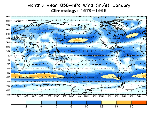
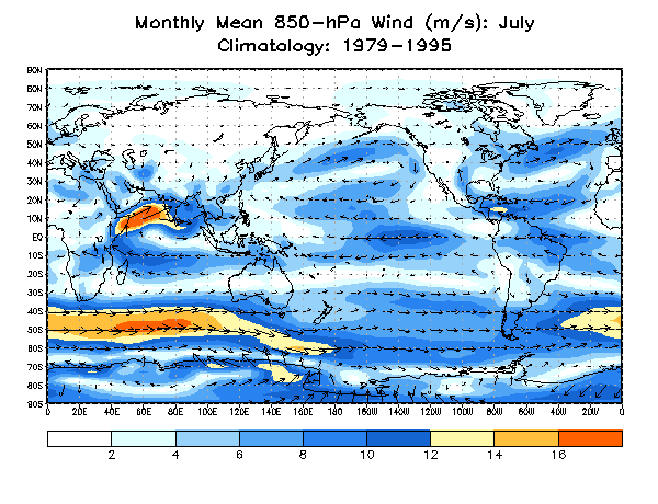
Seasonal variations in the 850-mb flow pattern can be discerned from inspection of the January and July maps. As at the surface, the patterns "follow the sun." On the January map, the winds across the Northern Hemisphere are relatively strong, since this month is in the heart of boreal winter. The strongest winds in this hemisphere are over the North Pacific and North Atlantic at approximately 35 degrees north latitude. In the Southern Hemisphere, the strongest summertime winds are over the Southern Oceans at approximately 50 degrees south. Also note that the winds across the North Indian Ocean are from the east and northeast as part of the wintertime Indian monsoon circulation regime. The July map at the height of boreal summer (austral winter) shows weaker winds across the North Pacific and North Atlantic, which are displaced farther to the north to approximately 40 degrees north latitude. Winds across the Southern Ocean are much stronger and displaced slightly northward. Strong southwest winds are found across the western North Indian Ocean and Arabian Sea as part of the summer Indian monsoon circulation regime.
Monthly variations in the 850 mb flow can be found at http://www.cpc.ncep.noaa.gov/products/precip/CWlink/climatology/Wind-850.shtml. Run your cursor across the list of month names above the map to see the variation from month to month.
UPPER TROPOSPHERIC FLOW
The CPC maps of the upper tropospheric flow are on the 200 mb (hPa) constant pressure surface, selected because this is near the maximum winds in the upper tropospheric jet stream.
http://www.cpc.ncep.noaa.gov/products/precip/CWlink/climatology/500hgt/500hgt.month.annual_1979-1995.gif
http://www.cpc.ncep.noaa.gov/products/precip/CWlink/climatology/500hgt/500hgt.NH.clim.jan_1979-1995.gif
http://www.cpc.ncep.noaa.gov/products/precip/CWlink/climatology/500hgt/500hgt.NH.clim.jul_1979-1995.gif
The monthly variations in the 200 mb flow are found at http://www.cpc.ncep.noaa.gov/products/precip/CWlink/climatology/Wind-200.shtml.
http://www.cpc.ncep.noaa.gov/products/precip/CWlink/climatology/200wind/200wind.clim.annual_y1979-1995.gif
http://www.cpc.ncep.noaa.gov/products/precip/CWlink/climatology/200wind/200wind.clim.jan_y1979-1995.gif
http://www.cpc.ncep.noaa.gov/products/precip/CWlink/climatology/200wind/200wind.clim.jul_y1979-1995.gif
http://www.cpc.ncep.noaa.gov/products/precip/CWlink/climatology/Height-500-NH.shtml
Apparently, the climatology of winds at 850 mb and at 200 mb are used by CPC to assess things in their Climate Diagnostics Bulletin.
http://www.cpc.ncep.noaa.gov/products/analysis_monitoring/bulletin_tmp/
http://www.cpc.ncep.noaa.gov/products/analysis_monitoring/bulletin_tmp/notes.shtml
see also
http://www.cpc.ncep.noaa.gov/products/analysis_monitoring/bulletin_tmp/figt20.shtml
http://www.cpc.ncep.noaa.gov/products/analysis_monitoring/bulletin_tmp/figt21.shtml
http://www.cpc.ncep.noaa.gov/products/analysis_monitoring/bulletin_tmp/figt7.shtml
http://www.cpc.ncep.noaa.gov/products/analysis_monitoring/bulletin_tmp/figt12.shtml
For following week
http://www.cpc.ncep.noaa.gov/products/precip/CWlink/stormtracks/strack_NH.shtml#composites
STORM TRACKS
http://www.cpc.ncep.noaa.gov/products/precip/CWlink/stormtracks/mstrack.shtml
The
Monitoring the recent evolution of storminess across both the Northern and Southern Hemisphere. Storm tracks are identified by tracking sea level pressure minima and the following pages highlight storm tracks and important related fields (precipitation, low-level wind vectors and magnitude, significant wave heights, and sea ice) for the past 10, 30, and 90 days. Storm tracks from the Global Forecast System (GFS) are also included. All data is provided courtesy of the Environmental Modeling Center (EMC) of the National Centers for Environmental Prediction (NCEP) as part of NOAA.
For Southern Hemisphere
http://www.cpc.ncep.noaa.gov/products/precip/CWlink/stormtracks/strack_SH.shtml
older discussion
http://www.cpc.noaa.gov/products/precip/CWlink/MJO/strack_body_final.html
|
18-Mar-02: Storm Track Climatology. http://wxprediction.com/storm_track2_files/slide0001.htm For Storm Tracks http://www.cpc.ncep.noaa.gov/products/precip/CWlink/stormtracks/mstrack.shtml Monitoring the recent evolution of storminess across both the Northern and Southern Hemisphere. Storm tracks are identified by tracking sea level pressure minima and the following pages highlight storm tracks and important related fields (precipitation, low-level wind vectors and magnitude, significant wave heights, and sea ice) for the past 10, 30, and 90 days. Storm tracks from the Global Forecast System (GFS) are also included. All data is provided courtesy of the Environmental Modeling Center (EMC) of the National Centers for Environmental Prediction (NCEP) as part of NOAA. For Southern Hemisphere http://www.cpc.ncep.noaa.gov/products/precip/CWlink/stormtracks/strack_SH.shtml older discussion http://www.cpc.noaa.gov/products/precip/CWlink/MJO/strack_body_final.html For AAO, NAO, PNA & AO http://www.cpc.ncep.noaa.gov/products/precip/CWlink/daily_ao_index/teleconnections.shtml For Blocking http://www.cpc.ncep.noaa.gov/products/precip/CWlink/MJO/block.shtml For ENSO http://www.cpc.ncep.noaa.gov/products/precip/CWlink/MJO/enso.shtml See this site LONG-LEAD FORECAST TOOL DISCUSSION AND ANALYSIS (REVISED 05/08) http://www.cpc.ncep.noaa.gov/products/predictions/long_range/tools.html Official 90-day Outlooks are issued once each month near mid-month at 3pm Eastern Time. Please consult the schedule of 30 & 90-day outlooks for exact release dates. http://www.cpc.ncep.noaa.gov/products/predictions/new_climates/90day/Mar/ or http://www.cpc.noaa.gov/products/predictions/new_climates/30day/Jan/ 1971-2000 Base Period Normals 90-Day Mean for Mar-Apr-May (Click on images to expand them.) These base period means are a preliminary set and are provided for the convenience of our customers. The final set will be implimented in our outlooks on May 17. http://www.cpc.ncep.noaa.gov/products/predictions/new_climates/90day/mam.html 1971-2000 Base Period Normals Month / Season 5-Day Means 7-Day Means 30-Day Means 90-Day Means at http://www.cpc.ncep.noaa.gov/products/predictions/new_climates/ |
|
|
BODY, TABLE, A, TH, TD{ font-family: PrimaSans BT,Verdana,sans-serif; font-size:x-small }
Return to DataStreme ECS website
Prepared by Edward J. Hopkins, Ph.D., email hopkins@meteor.wisc.edu
© Copyright, 2009, The American Meteorological Society.