WEEKLY CLIMATE NEWS
WEEK FIVE: 24-28 February 2014
ITEMS
OF INTEREST
- Worldwide GLOBE at Night 2014 Campaign continues -- The second of a series of GLOBE at Night citizen-science campaigns for 2014 will continue its 10-night run through this Friday after starting last Wednesday (19-28 February). GLOBE at Night is a worldwide, hands-on science and education program designed to encourage citizen-scientists worldwide to record the brightness of their night sky by matching the appearance of a constellation (Orion or Leo in the northern hemisphere, and Orion and Crux in the southern hemisphere) with seven star charts of progressively fainter stars. In addition to the 19-28 February campaign, the three additional GLOBE at Night campaigns are planned over the next three months of 2014: 21-30 March; 20-29 April and 19-28 May.
[GLOBE at Night]
- A change in meteorological seasons -- Friday,
28 February 2014, marks the end of meteorological winter in the
Northern Hemisphere, which by convention, is the three-month interval
of December, January and February. The following day (1 March 2014)
represents the beginning of boreal meteorological spring, the three
month interval of March, April and May. At the same time, summer in the
Southern Hemisphere ends and autumn begins.
- Leap years and calendars -- This year (2014) is considered a "normal" year with 365 days, while 2012 was a "leap" year with 366 days. Since the Earth completes one orbit around the Sun in
365.2422 days, calendars based upon integer days must be adjusted every
few years so that recognizable events, such as the occurrence of the
vernal equinox, do not progress through the year. In the first century
BC the Julian calendar was developed by Julius Caesar who decreed a
calendrical reform with a 365-day year that involved the inclusion of
an extra day to the end of February (the last month of the old Roman
year). However, an additional reform was instituted by Pope Gregory
XIII in 1572 that included the requirement that only those centurial
years divisible evenly by 400 would be leap years, while the other
centurial years (e.g., 1800 and 1900) would not.
The National Climatic Data Center recommends that the climate normals
for 28 February be used also for 29 February in a leap year.
- Monitoring the drought -- Read this
week's Supplemental Information...In
Greater Depth for information concerning assessing current
drought conditions across the nation.
CURRENT
CLIMATE STATUS
- Great Lakes ice cover expands -- Images obtained from several of the nation's environmental satellites last week show that the total ice cover on North America's Great Lakes has reached slightly more than 85 percent of the entire lake surface area. This ice cover far exceeds the previous winter season's 38 percent and was close to the record 94.7 percent set in 1979. One of the visible images was obtained from the sensors onboard NOAA's GOES-13 satellite in geosynchronous orbit. [NOAA Environmental Visualization Laboratory] Natural- and false-color images were also obtained by the MODIS sensors on NASA's polar-orbiting Aqua satellite. [NASA Earth Observatory]
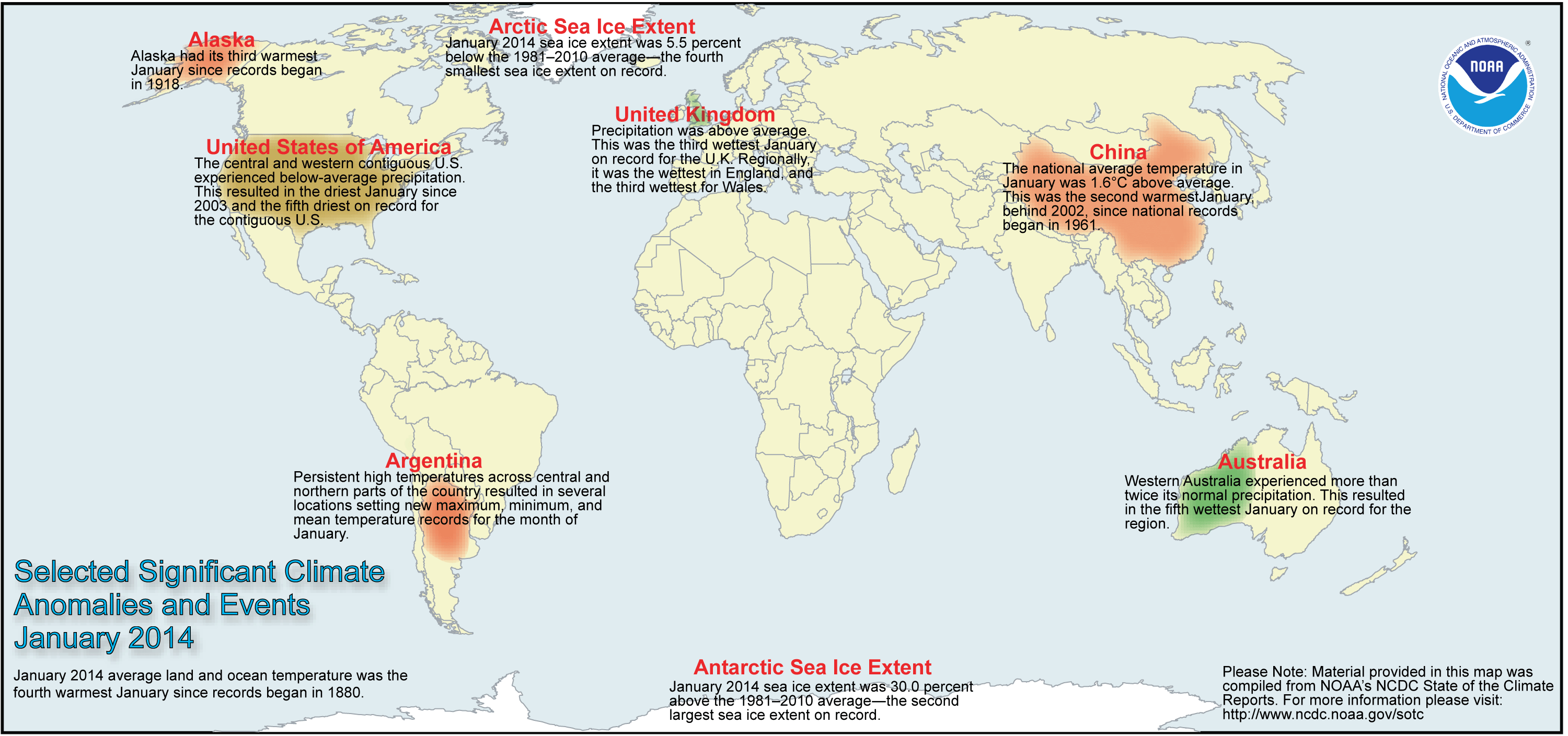
- Review of global weather
and climate for January 2014 -- Using preliminary data
collected from the global network of
surface weather stations, scientists at NOAA's National Climatic Data
Center have determined that the combined global land and ocean surface
temperature for January 2014 was 54.8 degrees Fahrenheit (or 12.7 degrees Celsius), which was the fourth highest global temperature for any
January since global climate records began in 1880. The average global
ocean surface temperature for January was the seventh highest on
record, while the global land surface temperature for January 2014 was
fourth highest. [NOAA/NCDC State of the
Climate]
According to the National Snow and Ice Data Center, the
Arctic sea ice was the fourth smallest monthly extent for any January since satellite surveillance began in 1979; the record smallest extent was in January 2011. On the other hand, Antarctic sea ice extent was the second largest January sea ice extent on record.
The extent of the Northern Hemisphere snow cover during January 2014
was
the tenth smallest for the period of record that
started in 1967. [NOAA/NCDC Global Snow & Ice]
NCDC also provides a map showing the Global Significant Weather and Climate Events map for January 2014.
CURRENT
CLIMATE MONITORING
- Satellites detect a faster rate of darkening of Arctic surface -- Researchers at Scripps Institution of Oceanography have found that data collected by sensors onboard several NASA satellites indicate a "darkening" of the sea ice on the Arctic Ocean because of diminution of the reflected sunlight from the Arctic ice surfaces due to the retreat of sea ice. Using data collected by the Clouds and Earth's Radiant Energy System (CERES) instrument onboard NASA's Tropical Rainfall Measurement Mission (TRMM) satellite, Terra, Aqua and NASA-NOAA's Suomi National Polar-orbiting Partnership (Suomi NPP) satellites, the researchers found that the reduction in the albedo or reflectivity in the Arctic region was by an amount considerably larger than previously estimated. They calculated that the overall albedo of the Arctic region fell from 52 percent to 48 percent between 1979 and 2011. [NASA Earth Science News Team]
- An All-Hazards Monitor -- This Web
portal provides the user information from NOAA on current environmental
events that may pose as hazards such as tropical weather, fire weather,
marine weather, severe weather, drought and floods. [NOAAWatch]
CLIMATE
FORECASTS
- Seasonal weather outlook released -- Late last week,
forecasters at the NOAA Climate Prediction Center released their new national Seasonal
Outlook for the next three months that consists of meteorological spring in the Northern Hemisphere (March-May). Specific details of their outlooks include:
- Temperature and precipitation outlooks -- According to their temperature outlook, nearly the southern half of the nation (consisting of the 48 coterminous states) extending from the Pacific coast to the Florida and the Atlantic Seaboard in the Southeast should experience a high chance of above average temperatures for Spring 2014. The greatest probability of such an occurrence is to be found across the Southwest, centered over Arizona along with southern and central California. Conversely, sections of the Upper Midwest, primarily across Minnesota, Wisconsin and Michigan were considered to have a better than average chance of below average temperatures for these three upcoming months. The outlook indicates that the remainder of the nation would have nearly equal chances of warmer or cooler than normal conditions.
Their precipitation outlook calls for sections of southern California and the central Gulf Coast to have a better than even chance of below average precipitation for Spring 2014.
A small area of the nation that includes the lower Ohio and mid-Mississippi Valleys was considered to be under a better than even chance of above average precipitation. Elsewhere, a large area of the coterminous states should have essentially equal chances of below and above average precipitation for meteorological spring.
A summary of the prognostic discussion of the 3-month outlook for non-technical users is available from CPC. These forecasts were based in part that assuming that the current ENSO-neutral conditions (ENSO = El Niño/Southern Oscillation) should continue through the Northern Hemisphere's meteorological spring (March-May), where neither El Niño nor La Niña conditions should prevail. A description is also provided as how to read these 3-class, 3-month Outlook maps.
- Seasonal Drought Outlook -- The
forecasters at NOAA's Climate Prediction Center also released their US
Seasonal Drought Outlook last week that would run from late-February through May 2014. Their outlook calls for persistence of the extensive drought conditions across most of the southwestern quadrant of the nation along with sections of the West, extending northward across California, Nevada and into Oregon. Several areas in the Southwest could see an intensification of drought conditions. On the other hand, sections of the Midwest and the Northwest could experience improvement in drought conditions, with a few areas possibly being removed from drought status.
Note: a Seasonal Drought Outlook Discussion is included describing the forecasters' confidence.
CLIMATE
FORCING
- Stratospheric sulfates linked to human activity -- Researchers from the National Center for Atmospheric Research (NCAR), the University of Colorado- Boulder, NOAA and the Massachusetts Institute of Technology have found that a layer of sulfate aerosols or particulate matter found near the boundary between the troposphere and stratosphere over Asia during the summer can be linked to emissions from human activity. These sulfate aerosols were produced from coal, oil and biomass not just over southern and eastern Asia, but from distant locations in the Middle East and North America. The layer of pollutants, which is known as the "Asian Tropopause Aerosol Layer" (ATAL), is found in summer (June through August) at altitudes between about 8 and 11 miles and extends from the eastern Mediterranean Sea to eastern China. The researchers determined the contributions made by the emissions using two NCAR-based computer models. [NCAR/UCAR NOAA AtmosNews]
- Future climate could have unstable Atlantic deep ocean circulation -- In a study conducted by researchers from Norway's Bjerknes Centre of Climate Research at the University of Bergen and their colleagues in Norway, the United States, France and the United Kingdom, conclude that Atlantic deep water formation appears to less stable than previously thought, which could mean that future changes in climate could lead to unstable deep ocean circulation in the Atlantic. The researchers based their conclusions on a reconstruction of surface ocean conditions and deep ocean circulation during the last interglacial approximately 125,000 years ago, when sudden sporadic short-lived changes in the influence of the North Atlantic waters in the deep ocean occurred. [EurekAlert!]
PALEOCLIMATE
RECONSTRUCTION
- Antarctica's Pine Island Glacier could experience current ice melt rate for decades -- A team of researchers including those at the US Department of Energy's Lawrence Livermore National Laboratory claims that the current rapid ice melt rate of the Pine Island Glacier, one of the major outlets of the West Antarctic Ice Sheet, may continue for decades, based upon analysis of transported material during a similar melting episode on the same glacier approximately 8000 years ago. Using mass spectrometry techniques, the researchers measured the concentration of beryllium-10 produced by cosmic rays in glacially transported rock. They determined the melting approximately 8000 years ago to be comparable to modern melting rates and these melt rates lasted for decades to centuries. [Lawrence Livermore National Laboratory]
- Investigation made of early rise of free oxygen on planet Earth -- Researchers at Yale University, the University of California, Riverside and the California Institute of Technology report that significant concentrations of oxygen arose in Earth's early ocean and atmosphere hundreds of millions of years before the "great oxygenation event" of approximately 2.3 billion years ago. During the time prior to this event, oxygen levels appeared to have fluctuated considerably. [Yale University News]
CLIMATE
AND HUMAN HEALTH
- Stroke hospitalization rates appeared tied to weather changes -- Researchers at the Yale School of Public Health have found that stroke hospitalization rates appear to rise and fall with sharp changes in outdoor air temperature and dewpoint, an indicator of atmospheric humidity. The researchers compared more than 157,000 hospital discharge records for ischemic stroke from across the country over a two-year span with temperature and dewpoint data, find that each 5-Fahrenheit degree change in daily temperature was associated with a 6% increased risk of stroke hospitalization, while each 5-Fahrenheit degree increase in dewpoint was associated with a 2% increase in stroke hospitalization. These associations were present even in winter. [Yale University News]
- Relationship may exist between crime and weather extremes -- Controversy remains as to whether a relationship exists between weather and crime. Recent evidence indicates some true to the old idea that violence decreases during cold weather, but increases during warm weather. [San Jose Mercury News]
CLIMATE
AND SOCIETY
- Earthweek -- Diary of the Planet [earthweek.com] Requires Adobe Acrobat Reader.

Concept of the Week: Keeping your cool!
In order to survive, humans need to maintain a nearly constant
internal core temperature that is within several degrees of 98.6
degrees Fahrenheit. Your internal temperature depends upon an energy
balance involving the gain and loss of energy from radiation (incoming
solar versus incoming and outgoing infrared radiation), sensible heat
transfer (conduction and convection), latent heat of evaporation
(respiration and perspiration) and the body's metabolic rate. This heat
transfer depends upon the differences between skin temperature and the
ambient air temperature of the surroundings. In addition, wind and
atmospheric humidity can affect the rate of sensible and latent heat
transfer. Problems arise when either too much or too little heat flows
to or from the body, yielding hypothermia and hyperthermia (heat
stress) conditions, respectively.
When the air temperature increases, heat flow from the body is
often reduced. Heat flow can be increased to maintain stable
temperatures involuntarily by thermoregulatory processes such as
increased perspiration (sweating) and dilation of the blood vessels.
Humans can also act to prevent hyperthermia by selecting lightweight
and light colored clothes, as well as seeking of shade and well
ventilated locations. Unfortunately, high atmospheric humidity that
often accompanies high summer temperatures also reduces body heat loss
since evaporative cooling by perspiration is suppressed. During the
summer, the National Weather Service alerts the public of potentially
dangerous combinations of high air temperature and atmospheric humidity
levels by calculating the Heat Index.
Statistics kept by the National Weather Service reveals that
heat (along with high humidity) is responsible for the greatest number
of weather-related deaths across the nation during the 10-year period
(2001-2010), with 115 fatalities occurring per year. By comparison, 116
fatalities per annum are caused by tropical cyclones (hurricanes and
tropical storms), 56 deaths per year are associated from tornadoes and
25 deaths annually caused by the cold (low temperatures). (Note: The
large number of fatalities associated with the hurricanes of 2005,
which totaled 1016 deaths in the US due primarily to Hurricane Katrina,
has inflated the annual averages associated with tropical cyclones.)
Furthermore, concern has been raised that during this century, more
frequent and more severe heat waves due to global climate change could
become more common, leading to a greater risk of hyperthermia and,
ultimately, to higher morbidity rates.
Concept of the Week: Questions
(Each week you will be asked to respond to two questions
relating to that week's Concept of the Week topic.
Place your responses on the Chapter Progress Response Form provided in
the Study Guide.)
- The heat index is a function of air temperature and [(atmospheric
humidity),(wind speed),(sunshine
levels)].
- The annual number of fatalities across the nation in the
last ten years due to heat stress is approximately [(15),(60),(120)].
Historical Events:
- 24 February 1905...The temperature at Valley Head, AL fell
to 18 degrees below zero, which was the lowest temperature ever
recorded in Alabama until January 1966. (Intellicast)
- 24-26 February 1910...Parts of Washington State were in the
midst of a storm that produced 129 inches of snow at Laconia between
the 24th and the 26th, a
single storm record for the state. A series of storms, which began on
the 23rd, led to a deadly avalanche on the first
of March. By late on the 28th, the snow had
changed to rain, setting the stage for disaster. (The Weather Channel)
- 24 February 1994...The Crystal Mountain ski resort in
Washington State recorded 65 inches of snow in a 24-hour period, the
state record for 24-hour snowfall. (Intellicast)
- 25 February 1914...South Carolina had its biggest snowstorm
in modern history, as 18 inches fell at Society Hill. (Intellicast)
- 25 February 1922...The temperature at Los Angeles, CA
soared to 92 degrees to establish a record for the month of February.
(David Ludlum)
- 26 February 1969...Both Portsmouth, NH and Portland, ME set
new single storm snowfall records with 33.8 inches and 26.9 inches,
respectively. (Intellicast)
- 27 February 1717...What was perhaps the greatest snow in
New England history commenced on this date. During a ten-day period, a
series of four snowstorms dumped three feet of snow upon Boston, and
the city was snowbound for two weeks. Up to six feet of snow was
reported farther to the north, and drifts covered many one-story homes.
(David Ludlum)
- 27 February 1988...Rapid City, SD established a February
record with an afternoon high of 75 degrees. (The National Weather
Summary) (Storm Data)
- 28 February 1900...A massive storm spread record snows from
Kansas to New York State. The 18.7 inches of snow measured at Topeka,
KS in 24 hours was the city's greatest 24-hour snowfall on record.
(David Ludlum) (Intellicast)
- 28-29 February 1964...A world 12-hour rainfall record was
set at Belouve, La Reunion Island in the western Indian Ocean when
52.76 inches of rain fell. World records for 9 hours and 18.5 hours
were also set with 42.79 and 66.49 inches, respectively. (Accord's
Weather Calendar) (The Weather Doctor)
- 28 February 1972...Unseasonably mild weather prevailed
throughout the central US. Temperatures soared to 83 degrees in Kansas
City, MO, setting an all-time high record for the month of February.
(Intellicast)
- 28 February 1988...Unseasonably mild weather prevailed in
the northwestern U.S. The afternoon high of 71 degrees at Portland, OR
was a February record. (The National Weather Summary) (Storm Data)
- 29 February 1964...Thompson Pass, AK finished the month
with 346.1 inches of snow, a record monthly total for the state of
Alaska. (The Weather Channel)
- 1 March 1910...The deadliest avalanche of record in the
U.S. thundered down the mountains near Wellington Station, WA sweeping
three huge locomotive train engines and some passenger cars off the
tracks, over the side and into a canyon, burying them under tons of
snow. This train was snowbound on the grade leading to Stevens Pass.
The avalanche claimed the lives of more than 100 people. The station
house at Wellington was also swept away. (The Weather Channel)
- 1 March 1993...4.5 inches of snow fell at Dodge City, KS on
this date to raise its seasonal snowfall total to 58.8 inches. This set
a new all-time seasonal snowfall record for the city. The old record
was 57.5 inches set back in the winter of 1911-12. (Intellicast)
- 2 March 1927...Raleigh, NC was buried under 17.8 inches of
snow in 24 hours, a record for that location. Nashville, NC received 31
inches of snow. The average snow depth in the state of Carolina was
fourteen inches. (The Weather Channel)
- 2 March 1947...The one-day record snowfall of 16 inches of
snow buried Canada's capital city of Ottawa, Ontario. The storm left
28.7 inches of snow covering the Ottawa region. (The Weather Doctor)
- 2 March 1996...Another East Coast snowstorm deposited 4.6
inches of snow at Central Park in New York City to bring its seasonal
snowfall total to 66.3 inches, breaking the old season snowfall record
of 63.2 inches set in 1947-48. (Intellicast)
Return to DataStreme
ECS website
Prepared by Edward J. Hopkins, Ph.D., email hopkins@meteor.wisc.edu
© Copyright, 2014, The American Meteorological Society.