WEEKLY CLIMATE NEWS
WEEK FIVE: 27 February-3 March 2017
Reports from the Field:
James Blink, a DataStreme LIT Leader from
Brentwood, CA, reported that he received more than three inches of rain at his house in the East Bay region of the San Francisco Bay Area on Monday of last week. In addition he had only four rain-less days in February. With recent heavy rain and a huge snowpack that has developed in the Sierra, many area dams are having to use spillways that have been dry for decades. Jim wonders -- "Drought or Flood, isn't there anything in between?" -- as he notes that "after several years of terrible drought, water rationing, rate increase, and fines set at levels far below historical water usage, the Northern California drought appears broken this year." Jim also mentions that a series of Pineapple Express storms coming in from the southwest direction, compared to the drought years that were dominated by a persistent giant high pressure center that lurked off the West Coast.
[Editor's note: the change from drought to soggy conditions across central California can be seen by comparing the color-enhanced images obtained from the Visible Infrared Imaging Radiometer Suite (VIIRS) instrument onboard the NOAA/NASA Suomi NPP satellite (NOAA Environmental Visualization Laboratory). EJH]
Dr. Steve LaDochy, a DataStreme LIT Leader and meteorology professor from Cal State University, Los Angeles, reports that the Los Angeles area is close to doubling its normal accumulated rainfall for this time of year with 18 inches; the annual average precipitation in Los Angeles is 15 inches. He received approximately three inches of rain at his house in a recent storm that was accompanied by downed trees, flooding and power outages. The rain filled all his rain barrels that catch runoff from the roof of his house. He noted that the lemon and orange blossoms are out, and so are the bees.
Steve also sent updated information from the local water and power utility in which the snow surveys near Mammoth Pass and Cottonwood in the Owens Valley last week were higher than the early March 1969 snow survey, which remains "the gold standard for wet years" over the record of their snow surveys dating back to the 1930s.
ITEMS
OF INTEREST
- A change in meteorological seasons -- Tuesday,
28 February 2017, marks the end of meteorological winter in the
Northern Hemisphere, which by convention, is the three-month interval
of December, January and February. The following day (1 March 2017)
represents the beginning of boreal meteorological spring, the three
month interval of March, April and May. At the same time, summer in the
Southern Hemisphere ends and autumn begins.
- Leap years and calendars -- This year (2017) is considered a "normal" year with 365 days. Last year (2016) was a leap year with 366 days, with one additional day inserted at the end of February. Since the Earth completes one orbit around the Sun in
365.2422 days, calendars based upon integer days must be adjusted every
few years so that recognizable events, such as the occurrence of the
vernal equinox, do not progress through the year. In the first century
BC the Julian calendar was developed by Julius Caesar who decreed a
calendrical reform with a 365-day year that involved the inclusion of
an extra day to the end of February (the last month of the old Roman
year). However, over several centuries, the timing of the vernal equinox (and the Christian celebration of Easter) crept earlier by roughly 10 days. To correct this inconsistency, an additional reform was instituted by Pope Gregory
XIII in 1572 that included the requirement that only those centurial
years divisible evenly by 400 would be leap years, while the other
centurial years (e.g., 1800 and 1900) would not.
The National Centers for Environmental Information (formerly National Climatic Data Center) recommends that the climate normals
for 28 February be used also for 29 February in a leap year. - Mardi Gras climatology --
Since Ash Wednesday, the beginning of the 40-day Lenten season observed by Christians, will begin on Wednesday (1 March), the day before (Tuesday, 28 February) is a day of celebration in many locations that is variously called Mardi Gras (French for Fat Tuesday) or Shrove Tuesday. One of the more famous Mardi Gras celebrations occurs each year in New Orleans, LA. The National Weather Service Forecast Office at New Orleans/Baton Rouge has a 2017 Mardi Gras Climatology that provides the normal temperatures and precipitation along with extremes for New Orleans during the Mardi Gras week prior to Ash Wednesday. Some additional statistics are provided.
- High-quality maps of March temperature and precipitation normals across US available -- The PRISM Climate Group at Oregon State University's website has prepared high-resolution maps depicting the normal maximum, minimum and precipitation totals for March and other months across the 48 coterminous United States for the current 1981-2010 climate normals interval. These maps, with a 800-meter resolution, were produced using the PRISM (Parameter-elevation Regressions on Independent Slopes Model) climate mapping system.
- March weather calendar for a city near you -- The Midwestern Regional Climate Center maintains an interactive website that permits the public to produce a ready to print weather calendar for any given month of the year, such as March, at any of approximately 270 weather stations around the nation. (These stations are NOAA's ThreadEx stations.) The entries for each day of the month includes: Normal maximum temperature, normal minimum temperature, normal daily heating and cooling degree days, normal daily precipitation, record maximum temperature, record minimum temperature, and record daily precipitation; the current normals for 1981-2010.
- Monitoring the drought -- Read this
week's Supplemental Information...In
Greater Depth for information concerning assessing current
drought conditions across the nation.
CURRENT
CLIMATE STATUS
- Arctic sea ice extent could be a record smallest winter maximum -- NOAA scientists recently reported that that this winter season's expansion of Arctic sea ice may be one of the smallest in history. They provide an animation of weekly Arctic sea ice concentration running from the second week of September 2016 through the second week of February 2017 obtained from satellite data. Typically, the maximum winter ice extent occurs in late February or early March. After commencing with the second smallest end-of-summer extent last September, a few periods of thaw in the Arctic occurred during this winter, which helped slow ice formation. [NOAA News]
Scientists who study the Arctic are concerned with how the unprecedented weather conditions and the lowest maximum extent of Arctic sea ice on record this winter will affect other features in the Arctic ecosystem. [NOAA News]
- Ice cover on Great Lakes down from recent winters --According to information furnished by NOAA's Great Lakes Environmental Research Laboratory, only 5.4 percent of the Great Lakes were covered with ice as of this past weekend, which compares with the 11.8 percent at the same time one year ago and the over 80 percent coverage during the recent two relatively cold winter seasons (2013-14 and 2014-15). Lake water temperature maps for each of the five lakes are also furnished for the last three seasons. [NOAA GLERL]
- Residents of Wisconsin's Apostle Islands concerned about a lack of lake ice -- The western Great Lakes have not had much lake ice this season because of the relatively warm winter across the Upper Midwest. Residents of Wisconsin's Madeline Island in the Apostle Islands in western Lake Superior have been inconvenienced by the lack of sufficiently thick ice that would normally support a midwinter "ice road" between Madeline Island and the community of Bayfield on the mainland. The ferry will run throughout this winter, as it has for the third time in the last six years. A decade ago, a Bayfield High School student collected 150 years of Lake Superior ice data from the records of ferry operation and a local newspaper to investigate evidence of climate change. He found that over the 150-year span the Lake Superior ice had decreased dramatically and since 1975 the ice season begun an average of 11.7 days later and ended three days earlier in every decade. A greater rise in lake temperature as compared with air temperature appears to be a contributing factor. [Minnesota Public Radio News]
- Lack of snow changes next weekend's Alaska's "Last Great Race" start -- The 2017 Iditarod Trail Sled Dog Race will begin on the morning (Alaska time) of Saturday, 4 March 2017, with a ceremonial start from downtown Anchorage. A restart will be on Monday morning when the 73 dog teams head out along the trail from Fairbanks, approximately 300 miles to the north. Typically, the restart of the race is at Willow, a community approximately 75 miles north of Anchorage, but the decision was made earlier this month to move the second start to Fairbanks because of little snow making for poor conditions in critical trail areas in the Alaska Range. This year will mark the third time in the race's 45-year history that the official race has started from Fairbanks, with 2003 and 2015 being the other years. The final destination is at Nome, approximately 1000 miles distant. A website is maintained for teachers and students interested in following the progress of the Iditarod and a 4th- grade teacher from Chicago, IL, who is the "2017 Iditarod Teacher on the Trail™." The race should be completed in 10 to 17 days.
Current weather conditions and weather forecasts for this year's checkpoint stations are available.
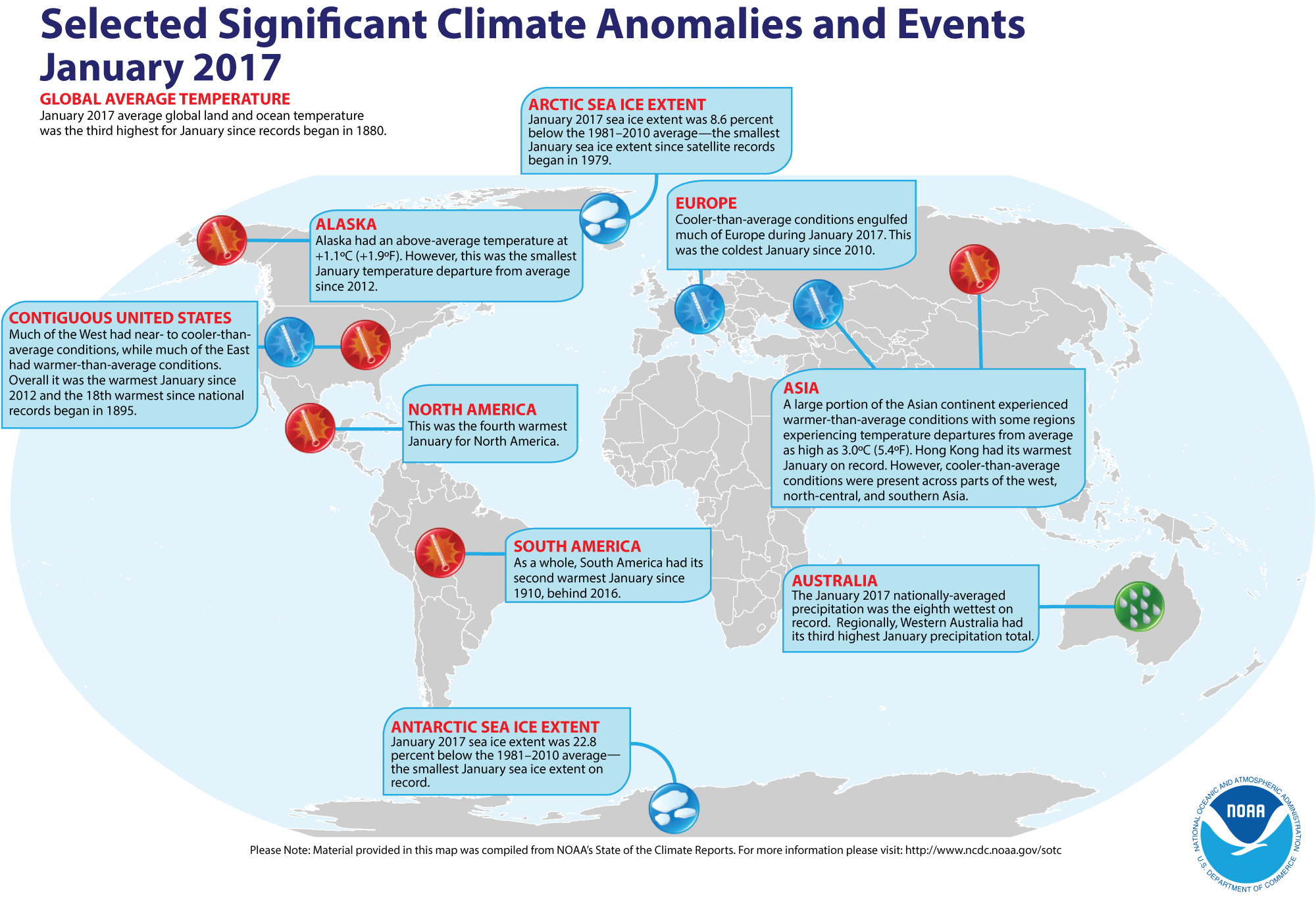
- Review of global weather
and climate for January 2017 -- Using preliminary data
collected from the global network of
surface weather stations, scientists at NOAA's National Centers for Environmental Information have determined that the combined global land and ocean surface
temperature for January 2017 was 1.58 Fahrenheit degrees (or 0.88 Celsius degrees) above the 20th-century (1901-2000) average, which makes last month the third highest global temperature for any
January since global climate records began in 1880. This reading trailed the record January 2016 temperature (1.87 Fahrenheit degrees above the 20th century average for the month) and the January 2007 temperature (1.55 Fahrenheit degrees above the long-term average). When considering land and ocean separately, the January 2017 ocean surface temperature was the second highest in the 138-year record, while the global land surface temperature for January 2017 was
third highest. [NOAA/NCEI State of the
Climate]
According to the National Snow and Ice Data Center, the
extent of Arctic sea ice was the smallest monthly extent for any January since satellite surveillance began in 1979. Antarctic sea ice extent in January also was the smallest on record in the Southern Hemisphere.
The extent of the Northern Hemisphere snow cover during January 2017
was
the sixth largest for the period of record that
started in 1967. [NOAA/NCEI Global Snow & Ice]
NCEI also provides a map showing the Global Significant Weather and Climate Events map for January 2017.
CURRENT CLIMATE MONITORING
- Recent record heat wave Down Under is detected by orbiting satellite -- A map of the peak land surface temperature across Australia was generated from data collected by the MODIS sensor onboard NASA's Terra satellite for the 7-14 February 2017 interval during the recent intense heat wave. This map shows land surface temperatures running between 50 and 60 degrees Celsius (122 to 140 degrees Fahrenheit), which exceed the routine air temperatures reported at shelter height of approximately 1.5 meters. [NASA Earth Observatory]
- Last flight of the season departs from South Pole Station -- In mid February scientists and staff from the National Science Foundation's Amundsen Scott Station at the South Pole departed on the last scheduled flight of the summer season, leaving a skeleton crew to "winter over" for the next nine months. Flights to the South Pole are suspended during the long Antarctic winter because the cold weather freezes equipment on the aircraft, making air travel hazardous. [NOAA Stories]
- Field campaign targets snow science in support of nation's water supply -- The first aircraft flights have been completed in western Colorado as part of the NASA-led SnowEx research campaign that is designed to improve remote-sensing measurements of the amount of snow that is on the ground at any given time and how much liquid water equivalent contained in that snow. The amount of water in snow plays a huge role in water availability for drinking water, agriculture, and hydropower. Nearly 100 scientists from universities and governmental agencies in the US, Canada and Europe will be participating in SnowEx, a multi-year project. The researchers will use five aircraft with a total of 10 different sensors in addition to ground-based equipment as part of the SnowEx campaign. Data acquired from the SnowEx campaign will be archived at the National Snow and Ice Data Center in Boulder, CO and will be available to anyone at no cost. [NASA Goddard Space Flight Center Feature]
CLIMATE
FORECASTS
- "Spring predictability barrier" in ENSO forecasts described -- A research associate at the NOAA Pacific Marine Environmental Laboratory wrote a guest post for the ENSO blog in which he discusses what has been termed the "spring predictability barrier", where attempts to correctly predict future El Niño, La Niña or ENSO-neutral conditions in spring are difficult. He claims that forecasting a La Niña event from the sea surface temperature patterns in the eastern equatorial Pacific may be easier than forecasting a future El Niño event. [NOAA Climate.gov News]
CLIMATE
FORCING
- Severe weather patterns in China have changed drastically since 1960 -- An international team of researchers recently reported on their analysis of severe weather patterns across China, finding that the frequency of hail storms, thunderstorms and high wind events has decreased by almost 50 percent on average since 1960. They based their analysis on observed weather data collected by a network of over 983 weather stations throughout China archived at the Chinese National Meteorology Information Center since 1951. Apparently, the strength of the East Asian Summer Monsoon appears to have decreased at a rate strongly correlated to that of severe weather throughout the same time period. Climate change may be one of the reasons that the Asian Summer Monsoon has weakened due to change in the temperature contrast between land and ocean. [Penn State University News]
CLIMATE
AND THE BIOSPHERE
- A case study involves a "coral bleaching story with an unknown ending" -- A case study is provided on the US Climate Resilience Toolkit that describes how people in American Samoa and the Independent State of Samoa are recognizing that changing ocean conditions are posing an increasing threat to the health and resilience of coral reefs and that they can now plan to protect these ecosystems found important to their islands. The US Climate Resilience Toolkit is a website developed by NOAA and the US Department of Energy that provides scientific tools, information, and expertise to help professionals manage their climate-related risks and opportunities, and improve their resilience to extreme events. A five step outline to resilience is provided. [US Climate Resilience Toolkit]
- Importance of riverine nutrients reaching the ocean is studied -- A team of researchers from academic research institutions in the United Kingdom, the Netherlands and Canada recently reported their findings on the amounts of nutrients in the form of dissolved nitrogen and phosphorus reaching the global oceans from the world's rivers using a new method for estimating the proportion of nutrients that reach the open ocean following biogeochemical processing along the continental shelf. They found that 75 percent of nitrogen and 80 percent of phosphorus from rivers cross the continental shelves into the open ocean. They claim that their estimates are crucial to understanding how anthropogenic activity and global climate change may affect global biogeochemical cycles. [EOS Earth & Space Science News]
CLIMATE
AND SOCIETY
- Mild weather losses caused by climate change will not be shared equally -- A contractor with the NOAA Climate Program Office wrote a feature for the NOAA ClimateWatch Magazine discussing recent research that found the number of "mild days" (with temperatures ranging between 64 and 86 degrees Fahrenheit, less than one half inch of rain and low atmospheric humidity) per year were expected to drop approximately 14 percent by 2100. She provided a global map with a plot of the anticipated change in the number of mild days per annum, identifying some of the areas around the world that would experience an increase in mild days. Furthermore, she notes a seasonality could occur with the projected change, with many areas expected to lose mild days in summer and gain mild days in winter. [NOAA Climate.gov News]
- Earthweek -- Diary of the Planet [earthweek.com]
Concept of the Week: Keeping your cool!
In order to survive, humans need to maintain a nearly constant
internal core temperature that is within several degrees of 98.6
degrees Fahrenheit. Your internal temperature depends upon an energy
balance involving the gain and loss of energy from radiation (incoming
solar versus incoming and outgoing infrared radiation), sensible heat
transfer (conduction and convection), latent heat of evaporation
(respiration and perspiration) and the body's metabolic rate. This heat
transfer depends upon the differences between skin temperature and the
ambient air temperature of the surroundings. In addition, wind and
atmospheric humidity can affect the rate of sensible and latent heat
transfer. Problems arise when either too much or too little heat flows
to or from the body, yielding hypothermia and hyperthermia (heat
stress) conditions, respectively.
When the air temperature increases, heat flow from the body is
often reduced. Heat flow can be increased to maintain stable
temperatures involuntarily by thermoregulatory processes such as
increased perspiration (sweating) and dilation of the blood vessels.
Humans can also act to prevent hyperthermia by selecting lightweight
and light colored clothes, as well as seeking of shade and well
ventilated locations. Unfortunately, high atmospheric humidity that
often accompanies high summer temperatures also reduces body heat loss
since evaporative cooling by perspiration is suppressed. During the
summer, the National Weather Service alerts the public of potentially
dangerous combinations of high air temperature and atmospheric humidity
levels by calculating the Heat Index.
Statistics kept by the National Weather Service reveals that
heat (along with high humidity) is responsible for the greatest number
of weather-related deaths across the nation during the 10-year period
(2001-2010), with 115 fatalities occurring per year. By comparison, 116
fatalities per annum are caused by tropical cyclones (hurricanes and
tropical storms), 56 deaths per year are associated from tornadoes and
25 deaths annually caused by the cold (low temperatures). (Note: The
large number of fatalities associated with the hurricanes of 2005,
which totaled 1016 deaths in the US due primarily to Hurricane Katrina,
has inflated the annual averages associated with tropical cyclones.)
Furthermore, concern has been raised that during this century, more
frequent and more severe heat waves due to global climate change could
become more common, leading to a greater risk of hyperthermia and,
ultimately, to higher morbidity rates.
Concept of the Week: Questions
(Place your responses on the Chapter Progress Response Form
provided in the Study Guide.)
- The heat index is a function of air temperature and [(atmospheric
humidity),(wind speed),(sunshine
levels)].
- The annual number of fatalities across the nation in the
last ten years due to heat stress is approximately [(15),(60),(120)].
Historical Events:
- 27 February 1717...What was perhaps the greatest snow in
New England history commenced on this date. During a ten-day period, a
series of four snowstorms dumped three feet of snow upon Boston, and
the city was snowbound for two weeks. Up to six feet of snow was
reported farther to the north, and drifts covered many one-story homes.
The storms killed 95 percent of New England's deer population. (David Ludlum) (National Weather Service files)
- 27 February 1988...Rapid City, SD established a February
record with an afternoon high of 75 degrees. (The National Weather
Summary) (Storm Data)
- 28 February 1900...A massive storm spread record snows from
Kansas to New York State. The 18.7 inches of snow measured at Topeka,
KS in 24 hours was the city's greatest 24-hour snowfall on record.
(David Ludlum) (Intellicast)
- 28-29 February 1964...A world 12-hour rainfall record was
set at Belouve, La Reunion Island in the western Indian Ocean when
52.76 inches of rain fell. World records for 9 hours and 18.5 hours
were also set with 42.79 and 66.49 inches, respectively. (Accord's
Weather Calendar) (The Weather Doctor)
- 28 February 1972...Unseasonably mild weather prevailed
throughout the central US. Temperatures soared to 83 degrees in Kansas
City, MO, setting an all-time high record for the month of February.
(Intellicast)
- 28 February 1988...Unseasonably mild weather prevailed in
the northwestern U.S. The afternoon high of 71 degrees at Portland, OR
was a February record. (The National Weather Summary) (Storm Data)
- 29 February 1884: San Diego, California saw its wettest February in history with 9.05 inches. February 1884 is currently the third wettest month on record (wettest: 9.26 inches in 12/1921). The year of 1884 ended as the wettest in San Diego history with 25.97 inches (National Weather Service files)
- 29 February 1964...Thompson Pass, AK finished the month
with 346.1 inches of snow, a record monthly total for the state of
Alaska. (The Weather Channel)
- 1 March 1910...The deadliest avalanche of record in the
U.S. thundered down the mountains near Wellington Station, WA sweeping
three huge locomotive train engines and some passenger cars off the
tracks, over the side and into a canyon, burying them under tons of
snow. This train was snowbound on the grade leading to Stevens Pass.
The avalanche claimed the lives of more than 100 people. The station
house at Wellington was also swept away. (The Weather Channel)
- 1 March 1993...4.5 inches of snow fell at Dodge City, KS on
this date to raise its seasonal snowfall total to 58.8 inches. This set
a new all-time seasonal snowfall record for the city. The old record
was 57.5 inches set back in the winter of 1911-12. (Intellicast)
- 2 March 1927...Raleigh, NC was buried under 17.8 inches of
snow in 24 hours, a record for that location. Nashville, NC received 31
inches of snow. The average snow depth in the state of Carolina was
fourteen inches. (The Weather Channel)
- 2 March 1947...The one-day record snowfall of 16 inches of
snow buried Canada's capital city of Ottawa, Ontario. The storm left
28.7 inches of snow covering the Ottawa region. (The Weather Doctor)
- 2 March 1996...Another East Coast snowstorm deposited 4.6
inches of snow at Central Park in New York City to bring its seasonal
snowfall total to 66.3 inches, breaking the old season snowfall record
of 63.2 inches set in 1947-48. (Intellicast)
- 3 March 1896...The temperature in downtown San Francisco,
CA fell to 33 degrees, which was the lowest ever for the city in March.
(Intellicast)
- 3 March 1971...An extremely intense coastal storm blasted
the northeastern US on this day and continued into the 4th. The
barometric pressure dropped to 960 millibars (28.36 inches) at
Worcester, MA for the lowest pressure ever recorded at the location.
The same record was set at Concord, NH with a reading of 963 millibars
(28.44 inches). Wind gusts 70 to 100 mph lashed eastern New England
with major wind damage occurring. Tides ran 4 to 5 feet above normal
resulting in extensive coastal damage and beach erosion. (Intellicast)
- 3 March 1994...A major coastal storm was in progress over
the mid-Atlantic and the Northeast. The 8.7 inches of snow at
Allentown, PA raised its seasonal snowfall to 69.2 inches for its
snowiest winter ever. Boston's 8 inches pushed its seasonal snow to
89.5 inches for its snowiest winter as well. (Intellicast)
- 3 March 2003...The day's low temperature of 30 degrees
below
zero at Marquette, MI was the lowest temperature ever recorded in March
in the city. (The Weather Doctor)
- 4-5 March 1899...Tropical Cyclone Mahina ("the Bathurst Bay
Hurricane") crossed Australia's Great Barrier Reef and generated
produced the highest storm surge ever recorded: 13-14.6 m (42.6-47.8 ft) surge in
Bathurst Bay. The Australian pearling fleet was destroyed, over 100
shipwrecks reported and 307 people killed, making Mahina the largest death toll of any natural disaster in Australian history. Minimum central pressure
barometric pressure fell to an unofficial reading of estimated at 914
millibars (26.90 inches of mercury). (Accord's Weather Calendar) (The
Weather Doctor) (National Weather Service files)
- 4 March 1953...Snow was reported on the island of Oahu in
Hawaii. (The Weather Channel)
- 5 March 1960...The greatest March snowstorm of record in
eastern Massachusetts began to abate. The storm produced record 24-hour
snowfall totals of 27.2 inches at Blue Hill Observatory, 17.7 inches at
Worcester, and 16.6 inches at Boston. (The Weather Channel)
- 5 March 1972...Palm Springs, CA recorded a high temperature of 100 degrees, the earliest the city has ever hit the century mark. (National Weather Service files)
- 5 March 2000...The Twin Cities of Minneapolis and St. Paul,
MN established a new record for the fewest number of days between
70-degree Fahrenheit temperature reading from the last date in the
autumn to the first date in the spring, with only 113 days passed. The
previous record was 131 days, while the average has been 175 days. (The
Weather Doctor)
Return to RealTime Climate Portal
Prepared by Edward J. Hopkins, Ph.D., email hopkins@aos.wisc.edu
© Copyright, 2017, The American Meteorological Society.