WEEKLY CLIMATE NEWS
22-26 May 2017
DataStreme Earth Climate System will return for Fall 2017 with
new Investigations files starting during Preview Week, Monday, 21 August 2017. All the current online website products will continue to be available throughout the summer break period.
ITEMS
OF INTEREST
- Twelve steps can create a sustainable high school -- A new activity was made available recently that contains 12 steps schools can use to be more sustainable and environmentally friendly. This tool is available through Connecticut Energy Education. [NOAA Climate.gov News]
- Worldwide GLOBE at Night 2017 Campaign is underway -- The fifth in the series of GLOBE at Night citizen-science campaigns for 2017 will continue through Friday, 26 May. GLOBE at Night is a worldwide, hands-on science and education program designed to encourage citizen-scientists worldwide to record the brightness of their night sky by matching the appearance of a constellation (Leo in the Northern Hemisphere and Crux in the Southern Hemisphere) with the seven magnitude/star charts of progressively fainter stars.
Activity guides are also available. The GLOBE at night program is intended to raise public awareness of the impact of light pollution.
The next series in the 2017 campaign is scheduled for 16-25 June 2017. [GLOBE at Night]
- Zenithal Sun -- Late this week (25-27 May) marks one of the two times during the year when the noontime sun is directly overhead to residents on Oahu (Honolulu metropolitan area). [US Naval Observatory, Data Services]
- North American Safe Boating Week -- The 2017 National Safe Boating Week will continue through Friday, 26 May. This week helps launch the 2017 North American Safe Boating Campaign. Check the Safe Boating Week site maintained by the Safe Boating Council.
- Climatology of Indy 500 Race Day-- Next Sunday, 28 May 2017, is the scheduled running of the 101st Indianapolis 500-Mile Race. The Indianapolis Forecast Office of the National Weather Service has a list of the pertinent weather and climate statistics for race day, including the average high and low temperatures, rainfall and wind for the 1911-2016 period and a listing of the top 20 temperature, precipitation and wind extremes for the previous races.
CURRENT CLIMATE STATUS
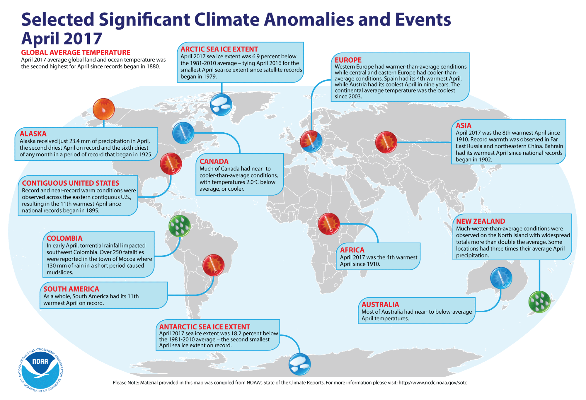
- Global temperatures for April 2017 reviewed -- Using
preliminary data collected from the global network of surface weather
stations, scientists at NOAA's National Centers for Environmental Information (NCEI) report
that the combined global land and ocean surface temperature for April
2017 was the second highest for any April
since comprehensive global climate records began in 1880; this temperature was 1.62 Fahrenheit degrees above the 20th century
(1901-2000) average. Only April 2016 had a larger positive ocean-land temperature departure. The scientists also reported
that when considered separately, the April 2017 average temperature over the
oceans was 1.31 Fahrenheit degrees above the 20th century average, representing the second highest ocean temperature departure on record, while the month's average temperature over the land surfaces was 2.42 Fahrenheit degrees above the long-term average, or the fourth highest April land temperature departure on record.
According to data from the Rutgers Global Snow Lab, the Northern Hemisphere snow cover extent for April 2017 was the 16th largest in the 51-year period of record.
April sea ice extent data
for the Arctic Ocean in 2017 tied April 2016 for the smallest sea ice on record since satellite records began in 1979. The and the sea ice on waters around Antarctica were the second smallest in the satellite era.
A global map of Selected Significant Climate Anomalies and Events for April 2017 is available from NCEI.
[NOAA/NCEI
State of the Climate]
CURRENT
CLIMATE MONITORING
- Annual report of the NOAA Climate Program Office for 2016 released -- During the past week NOAA's Climate Program Office (CPO) released its 54-page 2016 annual report that provides an overview of its activities and accomplishments made by this office in climate and ocean observation, research, modeling, and decision support activities for society. [NOAA Climate Program Office News]
- List of nation's billion-dollar weather & climate disasters updated for first three months of 2017 -- NOAA's National Centers for Environmental Information recently updated its "U.S. Billion-Dollar Weather & Climate Disasters 1980-2017" to include five recent weather and climate disaster events with losses exceeding $1 billion each across the United States during the first three months of 2017. These events included one flooding event, one freeze event, and three severe storm events. Overall, these events resulted in the deaths of 37 people and had significant economic effects on the areas impacted. [NOAA/NCEI]
- List of world weather records that produce highest mortality established -- The World Meteorological Organization (WMO) recently announced that its official "WMO Archive of Weather and Climate Extremes" has been expanded from temperature and weather records to tabulate and document "world records" for the highest mortality associated with tropical cyclones, lightning, tornadoes, and hailstorms. The highest mortality associated with a tropical cyclone is an estimated 300,000 people killed directly as result of the passage of a tropical cyclone through Bangladesh (at time of incident, East Pakistan) of 12-13 November, 1970. [WMO Press Release]
- "Year of Polar Prediction" for Arctic, Antarctic weather and sea-ice monitoring about to be launched -- The United Nation's World Meteorological Organization (WMO) will be launching the "Year of Polar Prediction (YOPP)", which is designed to improve predictions of weather, climate and ice conditions in the Arctic and Antarctic. YOPP will run from mid 2017 through mid 2019, to cover at least one complete year in each hemisphere. Currently, relatively little environmental data from the Earth's polar regions are available for use in forecasting. These regions are experiencing large changes due to a changing global climate. During this upcoming YOPP, special observing periods will be added to improve the number of routine observations, for example by weather balloon launches, and buoy deployments from research vessels to measure atmospheric and oceanographic conditions. [UN News Centre]
- Satellites play role in spotting wildfires -- NOAA National Environmental Satellite, Data, and Information Service (NESDIS) has posted a feature that describes how some of the nation's recent environmental satellites, such as GOES 16 and the Suomi NPP satellites, are being used to detect wildfires across land areas. Images of the recent West Mims Fire, which began burning in the Okefenokee National Wildlife Refuge along the Georgia-Florida border this past April, are featured. [NOAA NESDIS News]
CLIMATE FORCING
- Field campaign in Florida to study convective cloud and precipitation processes -- The Convective Processes Experiment (CPEX), a one-month long NASA-funded field campaign, will commence during this week in Florida as NASA's instrumented DC-8 aircraft will make a variety of atmospheric measurements of the birth, growth and decay of convective clouds. The intent of this campaign is to investigate the formation of precipitation from these clouds. The aircraft will be fitted with five complementary research instruments that include lidar, radar and radiometer units developed by NASA. Dropsondes will also be deployed by the aircraft during the campaign that is scheduled to have 10 to 16 flights. [NASA Jet Propulsion Laboratory News]
CLIMATE FORECASTS
- New Seasonal Climate Outlooks for this summer
issued -- Near the end of last week, forecasters at the NOAA
Climate Prediction Center (CPC) released their new national Three-Month
(Seasonal) Climate Outlooks for the upcoming summer season. These three
months, running from June through August 2017, are identified as
meteorological summer for the Northern Hemisphere. Specific details of
their outlooks include:
- Temperature and precipitation outlooks -- According to their temperature
outlook, a large section of the 48 contiguous United States should
experience a high chance of above average temperatures for these three
upcoming months, with the greatest probability of such an occurrence
being along the Atlantic Seaboard, the Gulf Coast and the Southwest. Nearly equal chances of warmer
or cooler than normal conditions were anticipated in the northern Rockies and adjacent Plains States, running from the Dakotas southward to Kansas, as well as eastward across the Upper Midwest to western Wisconsin.
Their precipitation
outlook calls for better than even chances of wet conditions
for summer 2017 along the northern and central Rockies and adjacent areas of the Plains, extending southward to the Texas Gulf Coast. The rest of the contiguous states should have equal chances of below
and above average summer precipitation.
Outlooks for June are also available. A summary
of the prognostic discussion of the outlook for non-technical
users is available from CPC. These forecasts were based in part on the anticipated trend toward El Niño conditions across the equatorial Pacific as summer in the Northern
Hemisphere transitions into autumn and early winter.
A contractor for NOAA's Climate Program Office wrote a feature for the ClimateWatch Magazine describing how to interpret the CPC seasonal outlooks and the associated maps for this upcoming meteorological summer season.
[NOAA Climate,gov News]
- Seasonal Drought Outlook released -- The
forecasters at NOAA's Climate Prediction Center also released their US
Seasonal Drought Outlook last week that would run from
mid-May through August 2017. Their outlook shows that most of the contiguous United States should not experience drought conditions through this upcoming summer, with only a few scattered areas across the southern tier of states continuing to have drought, including southern California and Arizona in the Southwest, and southern Georgia and adjacent South Carolina in the Southeast. The forecasters believe that sufficient improvement of the drought
conditions should occur across the southern Plains and sections of the Southeast to warrant the possible removal of these areas from drought status. Note: a Seasonal
Drought Outlook Discussion is included describing the
forecasters' confidence.
- Frequency of coastal flooding expected to double globally in next several decades -- Scientists at the US Geological Survey (USGS), the University of Illinois at Chicago and the University of Hawaii recently reported that the frequency and severity of coastal flooding around the world should increase rapidly and eventually double over the coming decades even with only moderate amounts of sea level rise. Thus dramatic increase in coastal flooding results from rising sea levels combined with storm-driven flooding, including the effects of wind driven waves and storm surge. They foresee the increase in flooding will be greatest and most damaging in tropical regions, impairing the economies of coastal cities and the habitability of low-lying Pacific island nations. [USGS News]
CLIMATE AND THE BIOSPHERE
- Changing climate conditions cause Eastern US tree species to spread westward -- A team of scientists from Purdue University, North Carolina State University, the US Forest Service's Southern Research Station and the University of Tennessee recently reported that over the past 30 years, most of the trees in the 86 tree species studied in the eastern United States have been shifting westward or northward in response to climate change. Deciduous trees (e.g., oak and maple) are tending to move primarily westward, while evergreens were moving northward. Apparently, precipitation and soil moisture may be significant factors when considering the impact that climate change can have on biodiversity and the sustainability of ecosystems. [Purdue University Agricultural News]
- Shift in marine species distribution expected to continue as ocean warms -- Using a high-resolution global climate model and historical observations of species distributions between 1968 and 2013 in the shelf waters off the Northeast U.S. coast, scientists with NOAA's Northeast Fisheries Science Center have found that commercially important marine species will continue to shift their distribution as ocean waters warm two to three times faster than the global average through the end of this century. These changes will impact local fishing communities and resource management. [NOAA Fisheries Northeast Fisheries Science Center News]
- Historic ocean data set reveals decrease in dissolved oxygen levels -- Researchers at Georgia Institute of Technology recently found that their analysis of a historic data set of ocean information stretching back more than 50 years indicates levels of dissolved oxygen in the seawater have been declining for more than 20 years. The oxygen levels, an important measure of ocean health, started dropping in the 1980s as ocean temperatures began to rise. Falling dissolved oxygen levels in seawater have the potential to impact the habitat of marine organisms worldwide and in recent years led to more frequent "hypoxic events" that killed or displaced marine species populations.[NCAR/UCAR AtmosNews]
- Crucial marine processes may change due to rising carbon dioxide levels and ocean acidity -- Researchers from Florida State University, Princeton University and China's Xiamen University warn that the acidification of seawater caused by rising atmospheric carbon dioxide levels increases the difficulty for Trichodesmium, a type of cyanobacteria, to perform a process called nitrogen fixation in the oceans. Since Trichodesmium is thought to be responsible for about 50 percent of marine nitrogen fixation, it is critical to the health of hundreds of species in the Earth's oceans as these cyanobacteria convert nitrogen gas into ammonia and other molecules that organisms are dependent on for survival. [Florida State University News]
CLIMATE
AND HUMAN HEALTH
- Heat-related deaths and emergency room visits increase in New England as heat index levels rise -- A team of public health researchers from Brown University and the state health departments in Maine, New Hampshire and Rhode Island recently reported that heat index values above 90 to 100 degrees Fahrenheit appear to have serious detrimental health effects on many residents of New England. The heat index is a measure that combines temperature and humidity to provide an indication of how hot it really feels especially at high temperatures and humidity levels. The researchers studied the association between maximum daily heat index (HI) and morbidity and mortality in 15 New England communities. Based upon this study, the National Weather Service is reconsidering forecast thresholds for issuing Heat Advisories in most of the New England states. [Brown University News]
CLIMATE AND SOCIETY
- Tornado strength may be a bigger factor than population size in tornado-related causality rates -- Researchers at Florida State University have found a relationship between total storm energy in a tornado, population size and the number of human casualties (deaths and injuries). Analyzing 872 casualty-causing tornadoes between 2007 and 2015 from the Storm Prediction Center (SPC) database, they calculated the per-tornado total kinetic energy (TKE) for all tornadoes using total path area and average wind speed for each tornado as the metric for the destruction intensity. The researchers found that tornado casualties depend more on storm energy than population. Concern has been raised that changing climate conditions could trigger more powerful tornadoes, which could result in more casualties; however, the researchers remain uncertain of any increases in intensity at the present time. [EOS Earth & Space Science News]
- "Hurricane-Ready Nation" being built one community at a time -- As part of its Flood Prepared Communities initiative, Pew Charitable Trusts, an independent non-profit, non-governmental organization, is working to reduce the human impact and high cost of flooding and rebuilding that typically follow natural disasters in ways that help ensure communities build smarter. Pew Charitable Trusts has teamed with former Charleston (SC) Mayor Joseph Riley to show how the city has addressed increasing storms and sea level rise since it was hit by Hurricane Hugo in 1989 with a 7-minute documentary entitled "After the Storm: Charleston's Blueprint for Disaster Recovery After Hurricane Hugo." [NOAA Weather-Ready Nation News]
- Earthweek -- Diary of the Planet [earthweek.com]
Historical Events:
- 22 May 1876...Denver, CO was drenched with 6.53 inches of
rain in 24 hours, an all-time record for that location. (The Weather
Channel)
- 22 May 1911...The temperature at Lewiston, ME soared to 101
degrees, the highest temperature ever recorded in New England during
the month of May. (David Ludlum)
- 22 May 1922...The United Kingdom recorded its hottest May
day on record when the thermometer hit 91 degrees at Camden Square,
London, England. (The Weather Doctor)
- 22 May 1980...The temperature at Winnipeg, Manitoba rose to
98.6 degrees, setting a record high for May. (The Weather Doctor)
- 23 May 1953...The temperature at Hollis, OK soared from a
morning low of 70 degrees to an afternoon high of 110 degrees, to
establish a state record for the month of May. (The Weather Channel)
- 24 May 2002...The last measurable snow for the season fell at Marquette, Michigan. This brought the city's seasonal snowfall to 319.8 inches, by far the city's snowiest winter ever. (National Weather Service files)
- 26 May 1967...A slow moving nor'easter battered New England
with high winds, heavy rain, and record late season snow on this day
and into the 26th. Over 7 inches of rain fell at Nantucket, MA with
6.57 inches falling in 24 hours to set a new 24-hour rainfall record.
The 24.9 inches of snow that fell at Mount Washington, NH set a new May
snowfall record. Other locations in New Hampshire received 10 inches of
snow near Keene and 6 inches at Dublin. (Intellicast)
- 26 May 2001...The 2000-2001 snowfall season finally ended
in St John's, Newfoundland, during which time a grand total of 255.3
inches of snow fell. The total snow, which broke a century-old mark,
was estimated to have weighed 500 million tons! (The Weather Doctor)
- 27 May 1948...The 1.5 inches of rainfall at Victoria,
British Columbia set the record for the wettest May day observed in the
provincial capital city. (The Weather Doctor)
- 28 May 1887...The temperature reached 97 degrees at San
Francisco, CA, establishing a record high temperature for the month of
May for the city. (Intellicast)
- 28 May 1942...The latest snowstorm of record for the state
of Iowa left ten inches at LeMars, eight inches at Cherokee, and 7.5
inches at Waukon. Afternoon highs were in the lower 30s in parts of
northwestern Iowa. (The Weather Channel)
- 28 May 1984...Sacramento, CA had its highest temperature
ever recorded in the month of May, when the temperature reached 110
degrees, breaking the old record of 100 degrees set in 1932.
(Intellicast)
- 28 May 2003...A new Nevada maximum temperature record for
May was set when the high temperature at Battle Mountain, NV rose to
102 degrees. (The Weather Doctor)
Return to RealTime Climate Portal
Prepared by Edward J. Hopkins, Ph.D., email hopkins@aos.wisc.edu
© Copyright, 2017, The American Meteorological Society.