WEEKLY CLIMATE NEWS
24-28 July 2017
DataStreme Earth Climate System will return for Fall 2017 with
new Investigations files starting during Preview Week, Monday, 21 August 2017. All the current online website products will continue to be available throughout the summer break period.
ITEMS
OF INTEREST
- Worldwide GLOBE at Night 2017 Campaign is underway -- The seventh in the series of GLOBE at Night citizen-science campaigns for 2017 will continue through Monday, 24 July. GLOBE at Night is a worldwide, hands-on science and education program designed to encourage citizen-scientists worldwide to record the brightness of their night sky by matching the appearance of a constellation (Hercules in the Northern Hemisphere and Scorpius in the Southern Hemisphere) with the seven magnitude/star charts of progressively fainter stars. Activity guides are also available. The GLOBE at night program is intended to raise public awareness of the impact of light pollution. The next series in the 2017 campaign is scheduled for 14-23 August 2017. [GLOBE at Night]
- Peak in the annual temperature curves -- This week represents the fourth full week of July, which for many locations across the nation are experiencing their warmest week of the year, as indicated by the daily normal high and low temperatures. Usually, those stations located away from the moderating influences of the oceans reach their highest temperatures during the third to fourth week of July, or a roughly one month after the summer solstice, when the Northern Hemisphere receives the most hours of daylight and the largest amounts of solar radiation. During July, temperatures continue to rise to their highest typical values as radiational heating continues. However, the length of daylight and the amount of sunshine during this month begin decrease and the normal daily temperatures will begin to fall toward their lowest levels in mid to late January. Comparison is invited with the "Warmest Day of the Year" maps generated for the nation by NOAA's National Centers for Environmental Information for the 1981-2010 normals interval.
- Zenithal Sun -- Residents of Hawaii's Big Island experienced a
noontime sun that would be directly overhead during this past weekend (22-23 July).
This occurrence of a zenithal sun is one of the two times during the year
when the noontime sun is directly overhead to residents of Hilo and
elsewhere on the Big Island. The other time when the Big Island experienced
a zenithal sun was in mid May [US
Naval Observatory, Data Services]
- Citizen scientists encouraged to carefully make atmospheric observations during next month's solar eclipse -- With the "Great American Solar Eclipse" being less than four weeks away (Monday, 21 August 2017), the GLOBE Program is encouraging the public to make observations of the atmosphere on the day of the total solar eclipse as it passes from west to east across the nation. The public is invited to make observations of the clouds (type and amount of cover) and air temperature and then post their results using a special GLOBE Observer app. NOTE: Safe eclipse observation techniques are mandatory as looking directly at even a small exposed portion of the Sun during the eclipse can cause serious eye injury. EJH
Additional observations such as surface temperature and other variables such as wind are encouraged. A special eclipse page for educators is available from GLOBE.
[Globe Observer]
CURRENT
CLIMATE STATUS
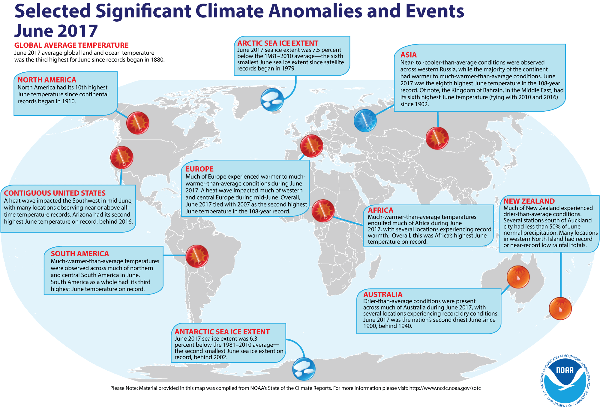
- Global temperature and ice cover for June 2017 reviewed -- Scientists at the NOAA National Centers for Environmental Information (NCEI)
recently reported on their analysis of preliminary weather data collected during the month of June 2017:
- The combined global land and ocean surface temperature for June
2017 was 1.48 Fahrenheit degrees above the 20th
century (1901-2000) average, which was the third highest temperature for any month of June since sufficiently detailed global climate records
began in 1880. When considered separately,
the average ocean temperatures for June 2017 was the third highest for
any June, while the average land surface temperature for this past month was the fourth highest June land temperature during the 138-year record.
Furthermore, the average combined land-ocean temperature through the first six months of the year (January through June 2017) was the second highest for the first half of any year since 1880, falling nearly 0.3 Fahrenheit degrees below the record set one year ago (Jan-June 2016).
- The researchers at the National Snow and Ice Data Center noted the areal extent of the Arctic sea ice
for June 2017 was
the sixth smallest for the month since satellite surveillance began in 1979. In addition, the extent of the Antarctic sea ice was the second smallest
in the 39-year record. [NOAA/NCEI
State of the Climate]
A global map of Selected Significant Climate Anomalies and Events for June 2017 is available from NCEI.
Using their own techniques to analyze the ground-based observations and satellite data to obtain a spatial average temperature, scientists at NASA's Goddard Institute for Space Studies (GISS) noted that the global composite temperature for June 2017 was the fourth-highest since 1880. (NOTE: The temperature anomalies, or arithmetic differences between current observed and a long-term average is based upon the 1951-1980 averaging interval, which differs from the 1901-2000 interval used by NCEI. EJH) [NASA Global Climate Change Feature]
- North American monsoon results in deadly flash flood in Arizona -- A meteorologist for NOAA's Climate Prediction Center describes how a combination of factors that included a rugged topography in southern Arizona and debris remaining from a large wildfire in the Tonto National Forest north of Phoenix during June created a situation conducive for flash flooding when rains returned to the region with the onset of the North American monsoon. As much as four inches of rain fell in mid July from thunderstorms that formed over the mountains of the Arizona due to seasonally dependent atmospheric processes associated with the North American monsoon, as described in the article. The flash floods were responsible for the loss of at least nine people to the north of Phoenix. [NOAA Climate.gov News]
CURRENT
CLIMATE MONITORING
- Amazon rainforest seen to make its own rainy season -- An international team of scientists recently reported that the southern Amazon rainforest triggers its own rainy season using water vapor that has originated from plant leaves. The researchers analyzed water vapor data obtained from satellites, especially from the Tropospheric Emission Spectrometer (TES) onboard NASA's Aura satellite. Their finding explains the seasonal timing of the rainy season in the southern Amazon basin. In addition, their discovery helps explain why reduced rainfall is linked with deforestation in this region. [NASA Jet Propulsion Laboratory News]
- Describing NOAA's support of ocean exploration and data collection -- The efforts of NOAA's Office of Ocean Exploration and Research (OER) to catalog and provide access oceanic data obtained from NOAA's Okeanos Explorer are described in an article posted on the National Centers for Environmental Information (NCEI) website. The Okeanos Explorer is NOAA's 224-ft long exploratory vessel that is equipped with cameras designed to provide real-time viewing of the ocean floor for scientists and for the public as part of its mission of gathering scientific information about oceans. Currently, a NCEI scientist is working in the vessel's wet lab as it is exploring the deepwater areas of the Pacific Ocean near the Johnston Atoll. NCEI is providing oceanographic and meteorological data obtained from its current expeditions on its website called "Okeanos Explorer Atlas." In addition, the "OER Digital Atlas" and the "OER Video Portal" are being prepared as data and video archives from over 260 OER missions. [NOAA NCEI News]
CLIMATE FORCING
- Rare infrared measurements to be taken during upcoming solar eclipse -- Scientists at the National Center for Atmospheric Research (NCAR) plan to comprehensively measure the infrared radiation streaming out from the Sun's corona when the moon passes in front of the Sun during the solar eclipse. The NCAR scientists will be making their measurements using instruments mounted on the NSF/NCAR Gulfstream-V (G-V) research aircraft that will be flying along the path of the eclipse shadow over Missouri and Kentucky to maximize the time of the eclipse and at a 40,000-foot altitude to minimize attenuation of radiation by clouds and atmospheric constituents. Several other instruments will be located on the ground at Casper Mountain, WY. Spectrometers will measure the infrared radiation emissions from the Sun and cameras will image light in both the near infrared and visible regions of the electromagnetic spectrum. The results could help researchers better understand the structure and evolution of the Sun's mysterious and chaotic magnetic fields. [NCAR/UCAR AtmosNews]
CLIMATE FORECASTS
- New Seasonal Climate Outlooks for late summer
and early fall issued -- Near the end of last week, forecasters at the NOAA
Climate Prediction Center (CPC) released their new national Three-Month
(Seasonal) Climate Outlooks new three-month seasonal national climate
outlooks for August through October 2017, corresponding to the last month
of the meteorological summer season (in the Northern Hemisphere)
and the first two months of meteorological autumn. Specific details of
their outlooks include:
- Temperature and precipitation outlooks -- According to their temperature
outlook, all of the 48 contiguous United States along with Alaska should experience a high chance of above average temperatures
for these three upcoming months. The forecasters express their highest confidence in their forecasts for sections of the Intermountain West, along with Eastern Seaboard and the Gulf Coast.
Their precipitation
outlook calls for better than even chances of dry conditions
for late summer and early autumn of 2016 across the Pacific Northwest, centered upon Washington's Olympic Peninsula. Conversely, sections of the southern Plains that include Texas and Oklahoma and in the Southwest, centered upon the Four Corners area (Arizona, Utah, Colorado and New Mexico) should have better than chance of above average precipitation. The rest of the 48 contiguous states should have equal chances
of below and above average summer precipitation. Southern sections of Alaska that include the southeastern Panhandle and the Alaska Peninsula in the southwestern sections of the state, should also have a good chance of wetter than average conditions during these next three months.
A summary
of the prognostic discussion of the 3-month outlook for
non-technical users is available from CPC. These forecasts were based
upon guidance from the dynamic prediction models and in part upon the anticipated continuation of ENSO conditions through the remainder of the year. A description is also provided as how to read these 3-class, 3-month Outlook maps.
- Seasonal Drought Outlook -- The
forecasters at NOAA's Climate Prediction Center also released their US
Seasonal Drought Outlook last week that would run from
late-July through October 2017. Their outlook would call for
persistence of drought conditions across the northern Plains, extending from the US-Canadian border south to the Sand Hills in north central Nebraska, as well as across southern California and southwestern Arizona. Drought conditions were expected to develop over the northern Rockies in northwestern Montana. Sections of the Southwest centered upon southern Arizona, together with scattered sections of the Plains running from Texas northward to the eastern Dakotas could experience some improvement in drought conditions, including their removal from drought conditions.
Note: a Seasonal
Drought Outlook Discussion is included describing the
forecasters' confidence.
CLIMATE
AND SOCIETY
- Public health officials in Minnesota help residents brace for heat waves -- The efforts undertaken by public health officials in Minnesota to help protect vulnerable populations in both rural and urban areas of the Gopher State from excessive heat events is highlighted by the U.S. Climate Resilience Toolkit, a website developed by NOAA and other Federal agencies. The Minnesota health officials produced the "Minnesota Extreme Heat Toolkit" designed to help communities implement a heat health plan in which the theme is BRACE or "Building Resilience Against Climate Effects." [NOAA Climate.gov News]
- Earthweek -- Diary of the Planet [earthweek.com]
Historical Events:
- 24 July 1928...Wahluke, WA hit a high temperature of 118 degrees, which tied a record high for the state. In August 1961, this all time state record high was tied at Ice Harbor Dam. (Intellicast)
- 24 July 1936...Record high temperature for Kansas was tied at 121 degrees near Alton. The record high for Nebraska was also tied at Minden with 118 degrees.
- 24 July 1942...The temperature at Las Vegas, NV hit 117 degrees to set an all- time record for that location. (The Weather Channel)
- 24 July 1952...The temperature at Louisville, GA soared to 112 degrees to establish a state record. This record for the Peach State was tied in August 1983. (The Weather Channel) (NCDC)
- 24-25 July 1979...Claudette, a weak tropical storm, deluged southeastern Texas with torrential rains. The Houston suburb of Alvin received 43.00 inches, a 24-hour precipitation record for not only the Lone Star State, but for the U.S. Freeport reported a total of 30 inches. Total damage from flooding was over $400 million. (Intellicast) (David Ludlum) (NCDC) (Accord's Weather Guide Calendar)
- 25 July 1979...Tropical Storm Claudette produced phenomenal rainfall totals in southeast Texas. Thirty to forty inches fell in 24 hours around Alvin. Freeport reported a total of 30 inches. Total damage from flooding was over $400 million. (Intellicast)
- 25 July 1987...Sixteen cities in the eastern U.S. reported record high temperatures for the date. Beckley, WV equaled their all-time record high of 91 degrees, established just the previous day. It marked their fourth day in a row of 90-degree heat, after hitting 90 degrees just twice in the previous 25 years of records. The water temperature of Lake Erie at Buffalo, NY reached 79 degrees, the warmest reading in 52 years of records. (The National Weather Summary)
- 26 July 1943...Tishomingo, OK baked in the heat as the mercury soared to 121 degrees, a Sooner State record high temperature. (The Weather Channel)
- 26 July 1960...The temperature at Salt Lake City, UT hit 107 degrees, an all-time record high for that location. (The Weather Channel)
- 26 July 1979...The U.S. record for 24-hour rainfall was set at Alvin, TX, with exactly 45 inches, thanks to Tropical Storm Claudette. (National Weather Service files)
- 27 July 1897...Jewell, MD received 14.75 inches of rain, which was a 24-hour rainfall record for Maryland. (NCDC)
- 27 July 1939...The temperature at Lewiston, ID hit 117 degrees to establish an all-time record high for that location. (The Weather Channel)
- 27-28 July 1984...Unprecedented rainfall fell at Alvsbyn in Sweden (approximately 62 miles south of the Arctic Circle), which was remarkable for such a northern location that is at about the same latitude as Fort Yukon, AK. On the 26th, 5.51 inches fell and on the 27th, an additional 5.63 inches were recorded. (Accord's Weather Guide Calendar)
- 27 July 1989...Thunderstorms produced locally heavy rains in the southwestern U.S. Yuma, AZ experienced their most severe thunderstorm of record. Strong thunderstorm winds, with unofficial gusts as high as 95 mph, reduced visibility to near zero in blowing dust and sand. Yuma got nearly as much rain in one hour as is normally received in an entire year. The storm total of 2.55 inches of rain was a record 24-hour total for July. Property damage due to flash flooding and high winds was in the millions. (Storm Data)
- 28 July 1930...The temperature at Greensburg, KY soared to 114 degrees to set a state record. (The Weather Channel)
- 28 July 1934...The temperature at Orofino, ID climbed to 118 degrees to establish a record for Idaho. (The Weather Channel)
- 28 July 1995...Yuma, AZ reached its all-time high temperature reading with 124 degrees. (Intellicast)
- 29 July 1898...The temperature at Prineville, OR soared to 119 degrees to establish a state record, which was tied on the 10th of August of that same year at Pendleton. (The Weather Channel)
- 29 July 1930...Mississippi's record high temperature of 115 degrees was set at Holly Springs. (Intellicast)
- 29 July 1958...The U.S. Congress passed legislation establishing the National Aeronautics and Space Administration (NASA), a civilian agency responsible for coordinating America's activities in space. (National Weather Service files)
- 30 July 1949...The state record temperature for Connecticut was established when the town of Greenville registered an afternoon high of 102 degrees. (The Weather Channel)
- 30 July 1965...The temperature at Portland, OR reached 107 degrees to equal their all-time record high. (The Weather Channel)
- 30 July 1999...At nine o'clock in the morning Chicago recorded its highest ever dew point temperature of 82 degrees. The temperature at the time was 88, resulting in a heat index of 108 degrees. The dewpoint is an indication of the amount of water vapor in the air. (National Weather Service files)
Return to RealTime Climate Portal
Prepared by Edward J. Hopkins, Ph.D., email hopkins@aos.wisc.edu
© Copyright, 2017, The American Meteorological Society.