Weekly Ocean News
24-28 September
2018
Items of Interest
- Looking back one year to Hurricane Maria -- During the last two weeks of September 2017, a major hurricane named Maria traveled westward across the tropical waters of the North Atlantic and the Caribbean before curving to the north and finally to the east-northeast. Starting as a tropical storm to the east of the Lesser Antilles on 16 September 2017, Maria strengthened to become a category 5 hurricane on the Saffir-Simpson Scale two days later before making landfall on Dominica. Although weakening slightly after traveling across Dominica, Maria reached its peak intensity over the eastern Caribbean with maximum sustained surface winds of 175 mph surrounding its center. With these winds and a central minimum pressure of 908 millibars (or 25.81 inches of mercury), Maria represents the tenth-most intense Atlantic hurricane on record and the most intense tropical cyclone worldwide in 2017. Maria then struck Puerto Rico as a category 4 hurricane on 20 September with winds of 155 mph. Weakening after crossing across Puerto Rico, Maria passed to the north of Hispanola on the 22nd before curving to the north and passing offshore of the U.S. East Coast by the 25th. Eventually, Maria weakened to a tropical storm on 28 September as it was carried toward the east-northeast, loosing its tropical characterstics and becoming an extratropical cyclone on the 30th. As many as 3057 fatalities can be attributed to Maria, with a recently revised official death toll of 2975 in Puerto Rico [Huffington Post]. Therefore, Maria has been declared the deadliest Atlantic hurricane since Hurricane Jeanne in 2004 and it has been tabulated as the third-costliest Atlantic hurricane ($91.6 billion in damage). [National Hurricane Center ]
- Tsunami Preparedness Week in American Samoa -- This week (24-28 September) has been designated Tsunami Preparedness Week in American Samoa. [NTHMP]
- September is National Preparedness Month -- The month of September has been declared National Preparedness Month (NPM), which is aims to educate and empower Americans to prepare for and respond to all types of emergencies, including natural disasters. NPM is managed and sponsored by the Federal Emergency Management Administration's (FEMA) Ready Campaign in conjunction with the Ad Council. A toolkit of marketing materials is provided to help promote the month and represents the lead on this campaign that was originally launched in 2004. The overarching theme for 2018 NPM is "Disasters Happen. Prepare Now. Learn How" with an emphasis on planning. Week 4 of the 2018 NPM (23-29 September) has the theme "Save For an Emergency."
[FEMA's Ready.gov]
- World Environmental Health Day to focus on air quality -- This Wednesday (26 September 2018) has been declared World Environmental Health Day by the International Federation of Environmental Health. This event is celebrated each year. The theme for the 2018 World Environmental Health Day is "Global Food Safety and Sustainability," which intended to provide more safe food and to make use of precious water and nutrient resources. In addition, support is for communities to increasingly value sustainable food production.
World Health Organization (WHO) claims that poor quality air affects more than 80% of the world's population. [International Federation of Environmental Health]
- Reconstructing past oceanic conditions from marine
sediment cores -- If you would like information on how
scientists can reconstruct past environmental conditions in the oceans
from the analysis of the physical, chemical and geological data in
deep-sea sediment cores, please read this week's Supplemental
Information...In Greater Depth.
Ocean in the News
- Eye on the tropics -- Tropical cyclone activity continued in the Atlantic, Pacific and Indian Ocean basins of the Northern Hemisphere during the last week, but at a pace that was less than during the previous week:
- In the North Atlantic Basin (that also includes the Caribbean Sea and Gulf of Mexico):
- Tropical Depression Florence continued to produce widespread torrential rain across sections of North Carolina, northeastern South Carolina and western Virginia at the start of last week, three days after Florence had made landfall along the southeastern North Carolina coast as a category 1 hurricane (on the Saffir-Simpson Scale). As of early Monday morning, the center of Tropical Depression Florence was located approximately 120 miles to the west-southwest of Roanoke, Virginia. Travel was to the north-northeast. By late afternoon, Florence had become an elongated post-tropical cyclone. Although becoming an elongated low pressure area by Tuesday morning, the remnants of Florence continued to produce flooding rains across the Middle Atlantic States and southern New England. By late Tuesday morning, the National Hurricane Center issued its last public advisory on post-tropical cyclone Florence as the center of this remnant low was located 45 miles to the west-northwest of Boston, MA.
The NASA Hurricane Blog Page has additional information and satellite images for former Hurricane Florence.
- Tropical Depression Joyce was traveling eastward across the eastern tropical North Atlantic at the start of last week, as it was located approximately 285 miles to the south-southwest of the Azores. Over the next day, this minimal tropical depression began curving to take a path toward the southeast and then to the south. By early Wednesday morning, Joyce had become a remnant low as it was located approximately 525 miles to the south of the Azores.
Satellite images and additional information for Tropical Storm Joyce can be found on the NASA Hurricane Blog Page.
- The eleventh tropical depression of 2018, identified as Tropical Depression 11 (TD-11), formed late Friday night approximately 510 miles to the east of the Windward Islands. Over the weekend, TD-11 drifted generally toward the west. By midday on Sunday, TD-11 degenerated into a trough of low pressure as it was 350 miles to the east-southeast of the Windward Islands.
- Tropical Storm Kirk formed this past Saturday afternoon (local time) over the waters of the North Atlantic approximately 450 miles to the south of the southernmost of the Cabo Verde Islands. Over the following 24 hours, Kirk traveled westward with little intensification. By early Monday morning, Tropical Storm Kirk had weakened to become a tropical depression as it was 835 miles to the west-southwest of the Cabo Verde Islands. Kirk was expected to continue traveling toward the west on Monday and Tuesday, with little change in intensity.
- Subtropical Storm Leslie developed Sunday afternoon approximately 1145 miles to the west-southwest of the Azores. (A subtropical storm is an organized low pressure system originating over tropical or subtropical waters that has without fronts, along with some characteristics of both a tropical and an extratropical cyclone or midlatitude low pressure system.) By early Monday, this system was traveling slowly toward the southwest, nearly 1245 miles to the west of the Azores. Leslie could become stationary later Monday before traveling toward the east on Tuesday, with little change in strength. However, this system could merge with a non-tropical low by midweek.
- In the eastern North Pacific basin (east of the 140-degree West meridian of longitude), the nineteenth tropical depression of 2018 formed over the waters of the Gulf of California approximately 35 miles to the northeast of Loreto, a city along the eastern coast of Mexico's Baja California Peninsula in the state of Baja California Sur. This system, identified as Tropical Depression 19E (TD-19E), traveled northward across the Gulf of California. TD-19E made landfall along coast of the state of Sonora in northwestern Mexico by early Thursday morning. Subsequently, TD-19E had dissipated approximately 55 miles to the east of Guaymas, a city in the state of Sonora. This system produced large amounts of rain across Baja California Sur and northwestern Mexico.
- In the western North Pacific basin (to the west of the International Dateline):
- Former Super typhoon Mangkhut, weakened as it traveled inland into southeastern sections of mainland China early last week after moving across Hong Kong. By early Tuesday Mangkhut had dissipated over Guangxi, China. The NASA Hurricane Blog Page has satellite images and additional information on former Super Typhoon Mangkhut.
- The 28th tropical storm of 2018 formed last week from a tropical depression. Named Trami, this tropical storm eventually became a typhoon, as it traveled toward the west and then to the west-northwest. As of Monday (local time), Trami had strengthened to become a category 4 typhoon (on the Saffir-Simpson Scale) as it continued traveling to the west-northwest. At that time, it was located approximately 710 miles to the south-southeast of Okinawa. Trami was expected to continue traveling to the west-northwest toward northern Taiwan early this week. Some intensification was possible.
The NASA Hurricane Blog Page [Note: Some versions of this blog had a title incorrectly identified this tropical cyclone as being in the South Pacific. EJH]
- In the North Indian Ocean basin: A tropical depression formed late last week over the west central Bay of Bengal. The system intensified to become Tropical Storm Daye by last Thursday, but by early Friday morning it had made landfall along India's Andhra Pradesh coast. Following landfall, Daye weakened into a tropical depression and by Saturday it had weakened to a remnant low.
New ICESat-2 satellite successfully launched -- During the predawn hours of Saturday, 15 September 2018, NASA's Ice, Cloud and land Elevation Satellite-2 (ICESat-2) was successfully launched into a polar orbit from the Vandenberg Air Force Base in southern California with a mission to measure the Earth's ice sheet mass balance and sea ice thickness. In addition, this satellite is intended to measure cloud as well as land topography and vegetation characteristics. ICESat-2, which follows the original ICESat that operated from 2003 to 2009, is designed to measure the Earth's ice elevation in the polar regions from an orbital altitude of approximately 290 miles with unprecedented accuracy. The satellite has a single instrument called the Advanced Topographic Laser Altimeter System (ATLAS) that will collect data needed to estimate the annual height change of the Greenland and Antarctic ice sheets to within four millimeters. [NASA Earth Observatory]
Hydrographic charts are updated to show new hazards and help ports recover from Hurricane Florence -- Navigation response teams from NOAA's Office of Coast Survey identified hazardous obstructions in North Carolina's Cape Fear River channel following the recent landfall of Hurricane Florence. NOAA updated its charts with the new hazards and distributed them to the port, Coast Guard, and key stakeholders in less than 24 hours, an unprecedented accomplishment for Coast Survey. [NOAA NCEI Coast Survey] Archived bathymetry and topography data help model hurricane impacts -- Staff at NOAA's National Centers for Environmental Information are supporting hurricane storm surge and flood modeling through the development of coastal digital elevation models (DEMs) that integrate bathymetry (details about the ocean floor) and topography in the coastal zones of the United States and other selected international locations. The resulting DEMs are representations of Earth's solid surface that depict land heights and water depths to visualize relief in coastal zones. NCEI has a vast archive of bathymetry data from various agencies such as NOAA, the U.S. Geological Survey, the U.S. Army Corps of Engineers and NASA. [NOAA NCEI News]
Infographic provides "A guide to plastic in the ocean" -- The NOAA Marine Debris Program has produced an infographic entitled "A guide to plastic in the ocean" that is intended to provide the public with a useful tool for visualizing information related to the amount of plastics found in marine debris. [NOAA National Ocean Service]
A marine debris team starts cleanup of the Northwestern Hawaiian Islands -- A marine debris team sailed onboard the NOAA Ship Oscar Elton Sette from Honolulu, HI last week for the Northwestern Hawaiian Islands on a mission to remove debris from these islands. This team will deploy a small unmanned aerial system to photograph and detect debris from above at Pearl and Hermes Atoll at their first stop. Specialized NOAA divers plan on cutting and removing derelict nets from reefs. The aim is to remove 30 to 50 metric tons of debris from the Papahanaumokuaea Marine National Monument. [NOAA Fisheries Feature Story]
New data obtained on U.S. Atlantic Margin gas hydrates from recent research cruise -- The U.S. Geological Survey (USGS) acquired data in late August about the distribution of gas hydrates in the sector stretching from the upper continental slope to deep water areas of the North Atlantic Ocean offshore New Jersey to North Carolina. These marine seismic data were obtained from the Mid-Atlantic Resource Imaging Experiment (MATRIX), which was jointly sponsored by the USGS Coastal/Marine Hazards and Resources Program, the Methane Hydrates R&D Program at the Department of Energy, and the Bureau of Ocean Energy Management. Gas hydrate deposits, which resemble ice, form naturally in seafloor sediments when methane and water combine at moderate pressures and relatively low temperatures. [USGS News]
Estimating the chances of being hit by a hurricane along the U.S. coast -- NOAA's National Hurricane Center is using an analysis tool that quantifies the frequency at which a hurricane can be expected to pass within 50 nautical miles of a specific location, expressed as the "hurricane return period." Thus, a return period of 20 years for a major Category 3 or stronger hurricane on the Saffir-Simpson Scale means that on average during the previous 100 years, a major hurricane passed within 50 nautical miles of that location about five times. NOAA's National Ocean Service provides an online tool that allows users to track the paths of historic hurricanes back to 1851, while NOAA's 2018 Atlantic and Pacific Hurricane Trackers permit tracking of current hurricanes from NOAA satellite in essentially real time. [NOAA Stories]
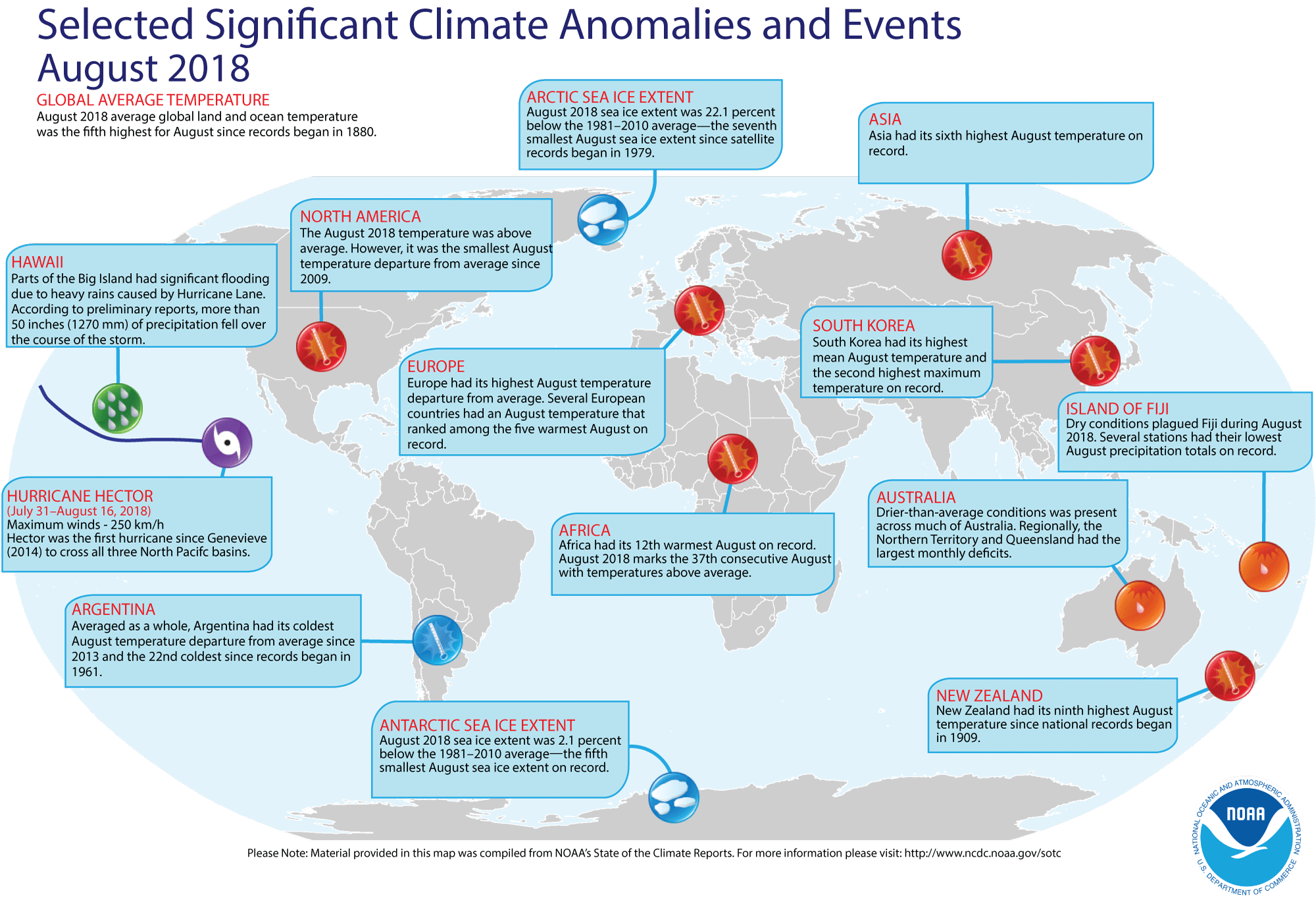
Review of August 2018 (and seasonal) weather and climate for the globe -- Preliminary data analyzed by scientists at
NOAA's National Centers for Environmental Information (NCEI) indicated:
- The global combined land and ocean average surface temperature for August 2018 was 1.33 Fahrenheit degrees above the 20th-century average (1901-2000) for
the month, which makes last month the fifth warmest August since a sufficiently dense network of global temperature records began in 1880; the warmest August on record was August 2016, which was 1.62 Fahrenheit degrees above the 1901-2000 average. When considered separately, the land surface temperature for this recently concluded month was the sixth highest August temperature in the 139-year record, with a monthly temperature that was approximately 1.69 Fahrenheit degrees above the 20th-century average. The August 2018 monthly temperature departure of the ocean surface was 1.21 Fahrenheit degrees above the 20th-century average, which was the fifth highest August temperature on record. ENSO-neutral conditions prevailed during August 2018, with close to average sea surface temperatures found across the central and eastern equatorial Pacific Ocean.
NOTE: Climate scientists prefer to generate long-time series of global temperatures using temperature anomalies (or the arithmetic differences between the observed monthly temperatures and the corresponding long-term 20th century averages), as a better means for gathering information in data-sparse areas or where missing station data present a problem. [NOAA Climate.gov News]
- A global map of Selected Significant Climate Anomalies and Events for August 2016 is available from NCEI.
- During the last three months, which constitutes meteorological summer in the Northern Hemisphere and meteorological winter in the Southern Hemisphere, the
combined global land and ocean average temperature for June-August 2018 was 1.33 Fahrenheit degrees above the 20th-century average, which also was the fifth highest for this three-month period since 1880. The June-August 2018 temperature for the global land surface was the fifth highest for any boreal summer in the last 139 years, while the three-month average ocean temperature tied the corresponding months in 2009 as being the fifth highest.
- According to data provided by the National Snow and Ice Data Center (NSIDC), the average August Arctic sea ice extent in the Northern Hemisphere was approximately 22 percent below the 1981–2010 average, making it the seventh smallest August Arctic sea ice extent since satellite records began in 1979. In the Southern Hemisphere, the August 2018 Antarctic sea ice extent was the fifth smallest August extent in the 40-year period of record.
[NOAA/NCDC
State of the Climate]
Three causes of Earth's spin axis drift are identified -- NASA scientists and colleagues from Germany, Norway and Denmark have identified three broadly-categorized processes responsible for the drift and wobble observed in the Earth's spin axis that is referred to as "pole motion." Based upon 20th century observations, this spin-axis drift has been determined to occur at a rate of about 4 inches (10 centimeters) per year. The researchers attribute the three causes to: ice mass loss primarily in Greenland, post glacial rebound, and deep mantle convection. [NASA Jet Propulsion Laboratory News]
NOAA's aquarium partners are engaging the public in marine conservation -- During this month of September, several of NOAA Education's partner aquariums have been holding events designed to engage the public in protecting coastal and marine ecosystems. Participating aquariums have been coordinating and collaborating on these events as members of the Coastal Ecosystem Learning Center Network, a consortium of 27 aquariums and marine science education centers across the United States, Canada, and Mexico. [NOAA News]
An All-Hazards Monitor-- This Web portal provides the user information from NOAA's National Weather Service, FAA and FEMA on
current environmental events that may pose as hazards such as tropical
weather, fire weather, marine weather, severe weather, drought and
floods. [NOAA/NWS Daily Briefing]
Earthweek -- Diary of the Planet [earthweek.com]
Concept of the Week: Variations in Marine
Sediment Thickness
Sediments are particles of organic or
inorganic origin that accumulate in loose form in depositional
environments such as lake or ocean bottoms. Marine sediments, the
central focus of this week's investigations, have a variety of sources
and exhibit a wide range of composition, size, and shape. Marine
sediments settle to the ocean floor as unconsolidated accumulations but
ultimately may be converted to solid sedimentary rock via compaction
and cementation. The pattern of variations in marine sediment thickness
on the ocean floor confirms some basic understandings regarding marine
geological processes.
Go to the RealTime Ocean Portal and
under "Geological," click on "Sediment Thickness." This map of marine
sediment thickness in the ocean basins was compiled by the National
Geophysical Data Center (NGDC), Marine Geology and Geophysics Division
primarily based on existing maps, ocean drilling, and seismic
reflection profiles. Sediment thickness is color-coded in meters from
violet (thinnest) to red (thickest). Many factors account for the
variation in the thickness of marine sediment deposits including type
and location of sediment sources, sediment transport mechanisms, and
the age of the underlying crust.
According to the map, sediment thickness generally increases
with distance from near the central portion of an ocean basin to the
continental margin. This pattern may be explained by the principal
sediment source and/or the age of the underlying crust. Rivers and
streams that empty into the ocean slow and diverge, releasing the bulk
of their suspended sediment load in coastal environments (e.g., bays,
estuaries, deltas) and onto the continental shelf. Ocean currents
transport sediment along the coast. In some areas of the continental
shelf, massive amounts of sediment accumulate, become unstable, and
flow down the continental slope to the base of the continental rise and
beyond. However, only the finer fraction of river-borne sediment is
swept into the deep ocean waters. Thickening of marine sediments in the
direction of the continental margin may also reflect the aging of
oceanic crust with distance away from divergent (spreading) plate
boundaries where new oceanic crust forms. The older the crust the
longer is the period that sediment rains down on the ocean bottom and
the thicker is the blanket of accumulated sediment.
The map indicates that the thickness of marine sediment
deposits is greater in the continental margin along the Atlantic coast
of North America than along the Pacific coast. The Atlantic coast of
North America is a passive margin; that is, the
continental margin is not affected significantly by tectonic processes
(no plate boundary) and the principal geological processes consist of
sedimentation along with erosion by ocean waves and currents. In fact,
passive margins and relatively thick marine sediment deposits occur on
both sides of the Atlantic. (Passive margins also occur around the
Arctic Ocean and surrounding Antarctica.) On the other hand, the
Pacific coast of North America is an active margin;
that is, the continental margin is associated with plate boundaries and
is subject to deformation by tectonic stresses. Active continental
margins are relatively narrow so that sediment delivered to the coast
by rivers and streams flows directly into deeper water or
trenches--preventing thick accumulations of marine sediments from
building in the continental margin.
Historical Events
- 25 September 1513...Vasco Núñez de Balboa, a Spanish
conquistador-explorer, crossed the isthmus of Panama and reached the
Pacific Ocean, which he christened Mar del Sur (South Sea), claiming
the ocean and all adjacent lands for Spain. (Wikipedia)
- 25 September 1939...A West Coast hurricane moved onshore
south of Los Angeles bringing unprecedented rains along the southern
coast of California. Nearly 5.5 in. of rain drenched Los Angeles during
a 24-hr period. The hurricane caused $2 million in damage, mostly to
structures along the coast and to crops, and claimed 45 lives at sea.
"El Cordonazo" ("the lash" or "whip") produced 5.66 in. of rain at Los Angeles and 11.6 in. of
rain at Mount Wilson, both records for the month of September. It was the only time in the 20th Century that the center of a tropical storm made landfall still at tropical storm strength on the California coast. (David
Ludlum) (The Weather Channel) (National Weather Service files)
- 25 September 1956...The world's first transatlantic
telephone cable system began operating (Clarenville, Newfoundland to
Oban, Scotland). Previous cables had been limited to telegraph
transmissions. (Today in Science History)
- 26 September 1580...English seaman Francis Drake returned
to Plymouth, England, in the Golden Hind, becoming
the first British navigator to circumnavigate the globe. He had
commenced his voyage around the world on 13 December 1577 with five
ships, but returned with only one ship. During his voyage in the
Pacific Ocean, he paused near San Francisco Bay and then traveled as
far north as present-day Washington State. He brought back valuable
information about the world's ocean to Queen Elizabeth I. (The History
Channel)
- 26-27 September 1959...Typhoon Vera ravaged Honshu, Japan,
the nation's largest island, leaving over 5000 dead, more than 40,000
injured, 1.5 million homeless and 40,000 homes destroyed. It was
Japan's greatest storm disaster to that date. (The Weather Doctor)
- 27 September 1854...After colliding with the French ship SS Vesta in dense fog, the American Collins Line
steamship Arctic sank with more than 300 people on
board near Cape Race, Newfoundland, marking the first great disaster in
the Atlantic Ocean. (Wikipedia)
- 27 September 1922...Report on observations of experiments
with short wave radio at the Naval Aircraft Radio Laboratory in
Anacostia, DC started US Navy development of radar. (Navy Historical
Center)
- 27 September 1958...A typhoon caused the death of nearly
5000 people on Honshu, the main Japanese island. (Wikipedia)
- 28 September 1542...Portuguese explorer Juan Rodríguez
Cabrillo sailed into present-day San Diego (CA) Bay during the course
of his explorations of the northwest shores of Mexico on behalf of
Spain. His landing at Point Loma Head apparently was the first known
European encounter with California. Before dying on the Channel Islands
off the Santa Barbara coast in January 1543, he had explored much of
the California coast. (The History Channel)
- 28 September 1850...An Act of Congress (9 Stat. L., 500,
504) provided for the systematic coloring and numbering of all buoys
for, prior to this time, they had been painted red, white, or black,
without any special system. The act "prescribed that buoys should be
colored and numbered so that in entering from seaward red buoys with
even numbers should be on the starboard or right hand side; black buoys
with odd numbers on the port or left hand side; buoys with red and
black horizontal stripes should indicate shoals with channel on either
side; and buoys in channel ways should be colored with black and white
perpendicular stripes." (US Coast Guard Historians Office)
- 28 September 1994...The auto ferry Estonia capsized and sank quickly in rough waters in the Baltic Sea. It was reported that there were at least 6-foot waves in the area. About 900 people lost their lives, while there were 141 survivors.
- 29 September 1959...Hurricane Gracie made landfall near
Beaufort, SC with sustained winds of 97 mph and a peak gust of 138 mph.
Ten people were killed in South Carolina and Georgia. As the weakening
storm moved through Virginia on the 30th, the storm spawned an F3
tornado at Ivy, VA, which killed 11 people. On the same day, a storm
produced 28 inches of snow in Colorado Springs, CO. (David Ludlum)
- 30 September 1932...Tropical cyclone rainfall of 4.38
inches at Tehachapi in southern California over 7 hours caused flash
floods on Agua Caliente and Tehachapi Creeks resulting in 15 deaths.
(The Weather Doctor)
- 30 September 1954...The USS Nautilus,
the world's first nuclear-powered submarine, is commissioned by the
U.S. Navy. In addition to breaking numerous submarine travel records to
that time, the Nautilus made the first voyage under
the Arctic sea ice at the geographic North Pole in August 1958, passing
from the Pacific to Atlantic Ocean basins. The Nautilus was decommissioned on 3 March 1980 and is currently on display at the
Submarine Force Museum in Groton, CT. (The History Channel)
- 30 September 1997...Omega Navigation Station Hawaii ceased
operation, coinciding with the end of worldwide Omega transmissions.
(USCG Historian's Office)
Return to RealTime Ocean Portal
Prepared by AMS Ocean Central Staff and Edward J. Hopkins,
Ph.D.,
email hopkins@aos.wisc.edu
© Copyright, 2018, The American Meteorological Society.