Weekly Ocean News
29 October - 2 November 2018
For Your Information
- Worldwide GLOBE at Night 2018 Campaign for November commences -- The eleventh in a series of GLOBE at Night citizen-science campaigns for 2018 will commence this Tuesday (30 October) and continue through Thursday, 8 November. GLOBE at Night is a worldwide, hands-on science and education program designed to encourage citizen-scientists worldwide to record the brightness of their night sky by matching the appearance of a constellation with the seven magnitude/star charts of progressively fainter stars. These constellations are Perseus in the Northern Hemisphere and Grus for the Southern Hemisphere. Activity guides are also available. The GLOBE at night program is intended to raise public awareness of the impact of light pollution. The twelfth and last series in the 2018 campaign is scheduled for 29 November-8 December 2018. [GLOBE at Night]
- World Tsunami Awareness Day -- The United Nations General Assembly has designated Sunday, 5 November 2018, as World Tsunami Awareness Day in recognition of the hazards that tsunamis pose around the globe. This year, World Tsunami Awareness Day will be aligned with the International Day for Disaster Reduction and the "Sendai Seven Campaign" and will focus on Target "c" of the Sendai Framework for Disaster Risk Reduction, which aims at reducing direct disaster economic loss in relation to GDP. [United Nations Office for Disaster Risk Reduction]
- Five interesting and "weird" ocean weather phenomena are highlighted -- As Halloween approaches, NOAA's National Ocean Service posted a feature called "Top Five: Weird Ocean Phenomena" containing pictures and explanations about several phenomena that occasionally occur as the result of weather and ocean currents. The five phenomena featured were: St. Elmo's Fire; Fog "Tsunami"; Meteotsunami; Waterspout; and Maelstrom. [NOAA National Ocean Service]
- Exploring ENSO patterns on a global scale -- An activity was created by a geology professor at Earlham College that allows high school and college students who have become familiar with ENSO (El Niño-Southern Oscillation) to explore the reality of ocean surface temperature (SST) data. Students analyze a time series of SST anomaly maps for a 14-year interval to create an ENSO timeline. [NOAA Climate.gov Teaching]
- "Falling back" next weekend -- Early next Sunday morning (4 November) most of the nation will revert back to Standard Time after nearly 8 months of observing Daylight Saving Time. Since Arizona, Hawaii and Puerto Rico do not observe Daylight Saving Time, no time change will be needed in those parts of the country. These changes have been mandated by the U.S. Congress in the Energy Policy Act of 2005, which extended Daylight Saving Time across the nation, with the start on the second Sunday in March (10 March 2019) and end on the first Sunday in November (3 November 2019). (Additional information is available from the National Institute of Standards and Technology.) Following the old adage of "spring ahead, fall behind", you will need to turn your clocks back by one hour to conform with the local time observance.
Most of Canada also observes changes to Daylight
Saving Time at the same time. [National
Research Council Canada].
A change from Daylight Saving to Standard Time does not deduct an extra
hour of daylight from the day nor does it affect weather and climate
patterns. The daily climate data collected at those automatic weather
stations operated by the National Weather Service and the Federal
Aviation Administration, together with all the cooperative weather
observing stations around the nation are always made according to local
standard time. NOTE: You may check the correct current official time at
http://www.time.gov/ - The history and future of "autonomous systems" in ocean research reviewed -- The project manager and technical lead for unmanned systems in NOAA's Office of Coast Survey was recently interviewed for the NOAA Ocean Podcast Series. In this 12:53-minute Podcast entitled "Unmanned Systems: Past, Present and Future," he describes how NOAA has been using "unmanned" vessels or "autonomous systems" to reduce operational costs and manpower requirements, while increasing the type and quality of data that NOAA collects. [NOAA National Ocean Service Ocean Podcast]
- Asteroids, climate change and mass extinctions -- You are invited to read this week's Supplemental
Information...In Greater Depth that describes how geoscientists have gathered evidence of five major mass extinctions over the last 550 million years from fossil records. These records also help in reconstructing past climates and help in the understanding of climate change.
Ocean in the News:
- Eye on the tropics -- Tropical cyclone activity was reported last week across:
- In the North Atlantic basin:
Subtropical Storm Oscar formed early Saturday morning (local time) approximately 1255 miles to the east-northeast of the northern Leeward Islands. At the time, Oscar was headed toward the north-northwest. Oscar continued to strengthen during the day and by late Saturday evening it had made a transition to a tropical storm as it curved to toward the west and then west-southwest. Traveling toward the southwest and back to west on Sunday, Tropical Storm Oscar continued strengthening, becoming the eighth Atlantic hurricane of 2018 by late afternoon when the system was 710 miles to the northeast of the northern Leeward Islands. As of late Sunday evening, Oscar, a minimal category 1 hurricane (on the Saffir-Simpson Scale), was located approximately 660 miles to the southeast of Bermuda. Oscar was forecast to strengthen on Monday and into Tuesday as it would head to the west and then northwest, without becoming a threat to any landmasses.
- In the eastern North Pacific basin:
- Tropical Storm Vicente, was traveling toward the west away from the southwest coast of Mexico at the start of last week. Over the course of last Monday, Vicente strengthened slightly during the morning as it curved toward the west-northwest, weakening as it turned to the northwest. As it traveled, this tropical storm produced torrential rains across southern and southwestern Mexico. During the predawn hours of Tuesday, Vicente had weakened to become a tropical depression as it headed toward the north northwest. With the next few hours, Vicente when it made landfall within 50 miles of Lazaro Cardenas, Mexico. Following landfall, became a remnant low, which then dissipated as it traveled inland across the Mexican State of Michoacan. The NASA Hurricane Blog Page has additional information and satellite images on Tropical Storm Vicente.
- Hurricane Willa was a rapidly intensifying hurricane that became a category 5 hurricane (on the Saffir-Simpson Scale) during the midmorning hours of last Monday as maximum sustained surface winds were estimated to have become 160 mph. At that time, Willa was traveling northward and was located approximately 135 miles to the southwest of Cabo Corrientes, Mexico. Willa, the ninth major hurricane (category 3 or higher) of 2018 in the eastern Pacific, had strengthened from a hurricane to category 5 status within a 36-hour span. By midafternoon on Monday, Willa weakened to a category 4 hurricane. Traveling to the north on Tuesday morning, Willa, a category 3 hurricane, crossed over Mexico's Islas Marias, an archipelago of four islands located approximately 230 miles to the southeast of the southern tip of Mexico's Baja California Peninsula. Curving toward the north-northeast, Willa made landfall as a category 3 hurricane on Tuesday evening along the western coast of Mexico near Isla Del Bosque, Sinaloa, or approximately 50 miles south of Mazatlan. Following landfall, Willa quickly weakened to a tropical storm and then a tropical depression near Durango, Mexico as it traveled toward the northeast. Crossing across Mexico, Willa finally dissipated on midmorning on Wednesday approximately 75 miles to the west of Monterrey, which is located in northeast Mexico. Abundant quantities of water vapor streamed associated with Willa streamed to the northeast into the Southern U.S. Additional information and satellite images are available on the
NASA Hurricane Blog Page.
- In western North Pacific Basin:
Tropical Storm Yutu intensified to a typhoon early last week as it east of the Marianas, or approximately 800 miles to the east-southeast of Guam. Continued intensification resulted in Yutu becoming the seventh super typhoon of 2018 in the western North Pacific. Yutu traveled across the islands of Saipan and Tinian in the U.S. Commonwealth of the Northern Mariana Islands by early Thursday as a category 5 typhoon on the Saffir-Simpson Scale with maximum sustained surface winds reaching 180 mph. The minimum central pressure was 919 mb. This category 5 super typhoon is considered to be the strongest storm of 2018 and the most powerful storm system to hit any part of the U.S. or its territories since the 1935 Labor Day Hurricane. After moving across Saipan and Tinian, Super typhoon Yutu weakened briefly before strengthening to category 5 status as it continued tracking toward the west on Friday. Over this past weekend, Yutu was heading toward northern sections of the Philippine island of Luzon, accompanied by a weakening of the system. As of Monday (local time), Yutu was traveling toward the west-southwest as a major category 3 typhoon, approximately 450 miles to the east-northeast of Manilla, Philippines. Current forecasts call for Yutu to make landfall along the coast of Luzon by Wednesday. After an anticipated crossing of Luzon, Yutu should curve toward the northwest and north as it travels across the South China Sea during the second half of this week. Consult the NASA Hurricane Blog Page for additional information and satellite images of Super Typhoon Yutu.
- Small tsunami wave generated in Ionian Sea from Greek earthquake -- A magnitude 6.8 earthquake off the Greek coast was responsible for a tsunami in the Ionian Sea early last Friday morning (local time). Tide gauges indicated a tsunami wave was generated, amounting to approximately seven inches. Although tsunami watches and advisories were posted for Greece, Albania and Italy, the height of the tsunami wave was not large and did not cause significant damage to the coasts of these countries. [RT News]
- NOAA research ship completes an around-the-world science mission -- The 242-foot long NOAA Ship Ronald H, Brown, the agency's largest oceanographic research vessel, returned to its home port of Charleston, SC last Monday, completing a 243-day voyage that took it around the world, with port calls in South Africa, the Seychelles, India, Australia and Hawaii. On this voyage, which commenced on 23 February, the crew and scientists conducted scientific research that included collecting plankton for study and more than 10,000 gallons of seawater for analysis. In addition, more than 80 buoys that provide data for global weather, climate and ocean forecasting were recovered, serviced or deployed.
[NOAA News]
- Marine ecosystems research program in Pacific marine sanctuaries for fall 2018 is highlighted -- NOAA scientists and their colleagues have been conducting research onboard the Exploration Vessel (E/V) Nautilus during this past summer and through this autumn in the waters of the North Pacific off the U.S. West Coast and around the Hawaiian Islands. The scientists used remotely operated vehicles (ROVs) to map and explore the marine ecosystems of Washington State's Olympic Coast National Marine Sanctuary in early July and the Papahanaumokuakea Marine National Monument in the Northwestern Hawaiian Islands during second half of September. Currently, the ship is exploring California's Monterey Bay National Marine Sanctuary (21-31 October). During the first half of this upcoming month (2-14 November), the Nautilus will be investigating the waters of California's Channel Islands National Marine Sanctuaries. The (E/V) Nautilus is a 64-meter research vessel owned by the Ocean Exploration Trust under the direction of Dr. Robert Ballard. [NOAA National Marine Sanctuaries Office]
- NOAA's GOES-17 satellite to be moved to its operational position as GOES-West -- Last Wednesday, engineers began moving NOAA's newest Geostationary Operational Environmental Satellite (GOES)-17 satellite westward from the position that it has occupied for the last seven months to position where it will become GOES-West. Following launch last March, the satellite was placed in a geosynchronous orbit of Earth (at an altitude of 22,240 miles), positioned above the Equator and at a longitude close to the 90th West meridian for testing of its onboard equipment. The current maneuver or "drift," which should be completed by 13 November, is to a position over the Equator at a longitude of 137.2 degrees West. In this position, GOES-17 will become GOES-West, providing a high-resolution view of weather systems across western North America (including southern Alaska), Hawaii and much of the Pacific Ocean. [NOAA National Environmental Satellite, Data, and Information Service News]
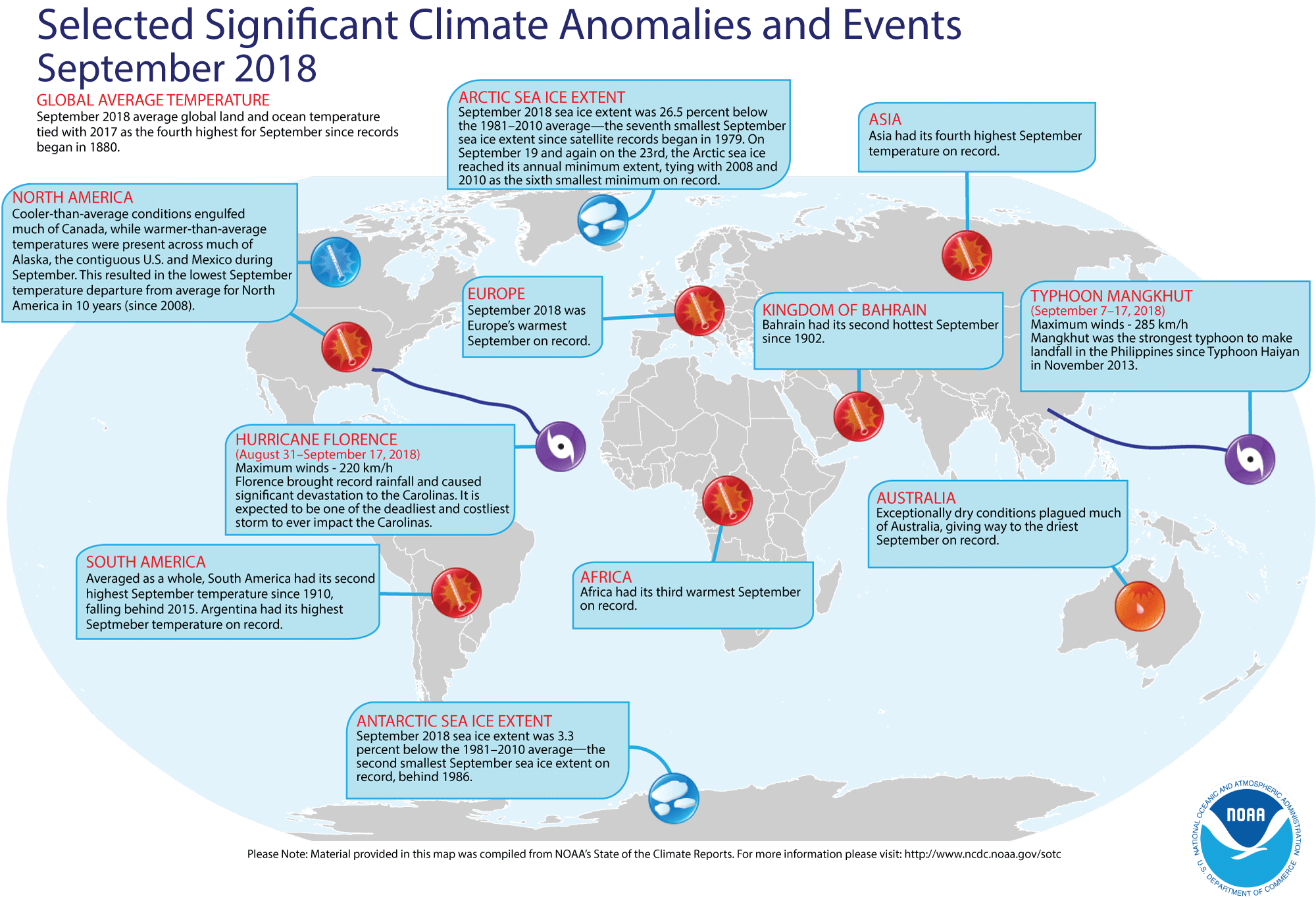
- September 2018 weather and climate for the globe reviewed -- Scientists at the NOAA National Centers for Environmental Information (NCEI)
recently reported on their analysis of preliminary weather data collected from around the world during the month of September 2018. They found:
- The global combined land and ocean average surface temperature for September 2018 was 1.40 Fahrenheit degrees above the 59.0 Fahrenheit degrees, which is the 20th-century average (1901-2000) for the month. Consequently, the September 2018 global September temperature essentially ties that for one year ago (September 2017) as being the fourth warmest September since a sufficiently dense network of global temperature records began in 1880. The warmest September on record was in 2015, which had a temperature departure of +0.93 Fahrenheit degrees above the 20th century average.
When considered separately, the land surface temperature for this recently concluded month was the sixth highest September temperature in the 139-year record, with a monthly temperature that was approximately 1.84 Fahrenheit degrees above the 20th-century average. For comparison, the September record for air temperatures over land was set in September 2016, which had a temperature departure from the 20th century average of +2.23 Fahrenheit degrees.
Over the oceans, the September 2018 globally-averaged sea surface temperature was 1.24 Fahrenheit degrees above the 20th century average, which was the fourth highest temperature on record for the month. The air over the oceans was the warmest in September 2015, with a temperature departure of +1.49 Fahrenheit degrees.
- According to data provided by the National Snow and Ice Data Center (NSIDC), the September Arctic sea ice extent in the Northern Hemisphere was approximately 26.5 percent below the 1981-2010 average, which tied September 2008 as the sixth smallest September Arctic sea ice extent since satellite records began in 1979. In the Southern Hemisphere, the September 2018 Antarctic sea ice extent was the second smallest September extent in the 40-year record.
- A global map of Selected Significant Climate Anomalies and Events for September 2018 is available from NCEI.
- A summary article on the September global climate highlights is available, while more detailed analysis with tables and maps can be viewed. [NOAA/NCEI State of the Climate]
- Investigating winter weather across U.S. during each El Niño winter since 1950 -- Two blogs were recently posted on the ClimateWatch Magazine that contain maps of average temperatures and precipitation across the 48 contiguous states for meteorological winter (December through February) during each of the 24 El Niño winters that have been identified since 1950. These winters that coincided with an El Niño have been ranked as being: strong (2015-16, 1982-83, 1997-98, 1957-58); moderate (1972-73, 1991-92, 2009-10, 1965-66, 1986-87, 1963-64, 1968-69, 1994-95) and weak (2002-03, 1953-54, 1987-88, 1976-77, 1977-78, 2006-07, 1958-59, 1979-80, 2004-05, 2014-15, 1951-52, 1969-70). The strength of the El Niño was based upon the Oceanic Niño Index (ONI). The variability from one El Niño to the next reveals a certain degree of uncertainty as to its effect upon seasonal climate.
- The maps for winter (DJF) precipitation during El Niño winters show a tendency for wetter than average conditions across the South, especially during moderate and strong El Niño winters. Wetter than average winters could be found along the Pacific Coast during a few strong and weak El Niño events. [NOAA Climate.gov News]
- The maps for winter temperature during an El Niño winter shows that the influence of El Niño upon temperature is less reliable than its influence on precipitation. The strongest El Niño events have resulted in unseasonably mild winters across most of the contiguous U.S., while cooler than average winters have been found across the South and East during some moderate and weak events. [NOAA Climate.gov News]
Note: Earlier this autumn, a blog posted to the site featured a summary of snowfall during El Niño winters between 1950 and 2009. [NOAA Climate.gov News]
- The Climate Explorer tool is available to help envision climate projections for climate adaptation -- An expanded and enhanced version of the research application tool entitled The Climate Explorer has been made available to the public that allows users to envision a range of potential future weather and tidal conditions, so they can consider and implement climate-smart adaptation strategies. The Climate Explorer, which is an integral part of the U.S. Climate Resilience Toolkit, provides historical observations and projections for climate variables for any county in the contiguous United States through 2100 in interactive graphical and map formats. [U.S. Climate Resilience Toolkit]
- Unearthing ice age climate clues -- A scientist at Rice University and her colleagues at other research institutions have created a proxy system modeling (PSM) technique that can be used in paleoclimatology to improve the interpretation of paleoclimate data. Their package of comprehensive and consistently formatted computational models is called PRYSM, where information collected from water-isotope based climate proxies (ice cores, corals, tree ring cellulose, and speleothem calcite) can be used to translate data in a way that relates more directly to measurable climate model variables. conventions. PRYSM is a modeling toolbox that is publicly available and facilitates proxy-climate (simulated or historical) comparisons. [Rice University News]
- An All-Hazards Monitor -- This Web portal provides the user information from NOAA's National Weather Service, FAA and FEMA on
current environmental events that may pose as hazards such as tropical
weather, fire weather, marine weather, severe weather, drought and
floods. [NOAA/NWS Daily Briefing]
- Earthweek -- Diary of the Planet [earthweek.com
Concept of the Week: Controlling Nutrient
Input into Chesapeake Bay
Chesapeake Bay is the nation's largest estuary; it is more
than 300 km (185 mi) long, 65 km (40 mi) at its broadest, and averages
about 20 m (66 ft) deep. The estuary was formed by the post-glacial
rise in sea level that flooded the valley of the ancient Susquehanna
River. The Bay receives about half its water from the Atlantic Ocean
and the other half from the more than 150 rivers and streams draining a
166,000-square kilometer land area encompassing parts of New York,
Pennsylvania, West Virginia, Delaware, Maryland, Virginia, and the
District of Columbia. Major rivers that empty into Chesapeake Bay
include the Potomac, Susquehanna, York, and James.
As described in more detail in your AMS
Ocean Studies textbook, an estuary is a complex and highly
productive ecosystem where seawater and freshwater runoff meet and mix
to some degree. In Chesapeake Bay, more-dense seawater creeps northward
along the bottom of the estuary, moving under the less-dense fresh
water flowing in the opposite direction. This circulation combined with
wind-driven and tidal water motions causes salinity to decrease
upstream in the Bay, from values typical of the open ocean at its mouth
to freshwater values at its northern margin.
As in all ecosystems, organisms living in estuaries depend on
one another and their physical environment for food energy and habitat.
Phytoplankton and submerged aquatic vegetation (e.g., marsh grass) are
the primary producers (autotrophs) in estuarine food chains. Chesapeake
Bay consumers (heterotrophs) include zooplankton, finfish, shellfish,
birds, and humans.
Human activity has greatly modified Chesapeake Bay with
consequences for the functioning of the ecosystem. Much of the original
forests that covered its drainage basin were cleared and converted to
farmland, roads, cities, and suburban developments. These modifications
accelerated the influx of nutrients (i.e., compounds of phosphorus and
nitrogen), sediment, pesticides, and other pollutants into the Bay.
More nutrients spur growth of algal populations and when these
organisms die (in mid-summer), their remains sink to the bottom.
Decomposition of their remains reduces dissolved oxygen levels in the
Chesapeake's bottom water. More sediment increases the turbidity of the
water, reducing sunlight penetration for photosynthesis. Presently
Chesapeake Bay is on the Federal list of "impaired waters" and in need
of pollution abatement and remediation. States in the drainage basin
have agreed to work together to clean up the Bay but there are
significant obstacles including cost.
One casualty of human modification of the Chesapeake Bay
ecosystem was marsh grass-reduced by 90% from historical levels. Marsh
grass anchors sediment and dampens wave action thereby controlling
shoreline erosion and turbidity. Marsh grass is a food source for many
organisms including waterfowl and small mammals and serves as a primary
nursery for crabs and many species of fish. Reduction of this habitat
along with over-fishing has been implicated in the decline of
populations of blue crabs, a mainstay of the Bay fishery for more than
a century. Over the past decade, the number of adult female blue crabs
plunged by 80%. Without adequate protection by marsh grass, blue crabs
are more vulnerable to predation by striped bass (i.e., rockfish).
Striped bass turned to blue crabs as a food source when fishing reduced
the numbers of menhaden, their preferred food. Menhaden is a marine
fish in the herring family and the Bay's top fishery by weight.
Human modification of the Chesapeake Bay drainage basin
converted it from an essentially closed system to
an open system. In the original climax forests,
nutrients primarily cycled within the system with relatively little
input to the Bay. Modification of the land for agriculture increased
the area of the soil exposed to the elements and runoff from rain and
snowmelt accelerated nutrient input into the Bay. In addition to such
non-point (area) sources of nutrients are point sources including the
effluent of wastewater treatment plants that discharge treated water
into rivers and streams that drain into the Bay.
For decades, agriculture has successfully employed various
cultivation practices that limit the runoff from cropland (e.g.,
contour plowing, strip cropping, and retention ponds.) However, less
than one-third of the 300-wastewater treatment facilities located in
the Chesapeake Bay drainage basin have the technology to remove high
levels of nutrients from their effluent. Under current environmental
regulations, states are not required to regulate the nutrient content
of this discharge. But in late October 2003, the Chesapeake Bay
Foundation, a private, not-for-profit environmental advocacy
organization called on Virginia, Maryland, Pennsylvania, and the
District of Columbia to specify nutrient limits on permits they grant
to all wastewater treatment facilities. In support of their
recommendations, the Chesapeake Bay Foundation cited the many water
quality problems stemming from excessive nutrient load in the Bay
waters (e.g., algal blooms, spread of "dead zones.") According to the
U. S. EPA, under the federal Clean Water Act, a state can control
nitrogen pollution if it determines that environmental harm is taking
place. However, the EPA estimates that as much as $4.4 billion would be
required to install state-of-the-art nutrient removal technologies at
all major plants (those treating more than 500,000 gallons of
wastewater per day).
Historical Events:
- 29 October 1867...A hurricane struck Puerto Rico, sinking 50 ships and killing over a thousand people along its path. This is still one of the strongest hurricanes in Puerto Rico's history. (National Weather Service files)
- 29 October 1999...Tropical Cyclone 5B, with sustained winds
of 155 mph, made landfall at Paradwip (Orissa, India). A storm surge of
at least 20-ft height swept at least 12 mi inland. This is the strongest tropical cyclone ever record in the North Indian Ocean. More than 10,000
people were killed. With 2 million homes either damaged or destroyed,
35 million people were left homeless. Damage from this tropical cyclone
was $1.5 billion. (Accord Weather Guide Calendar)
- 29 October 2012...Hurricane Sandy roared into the New Jersey shore bringing 80-mph winds and 30-foot waves to the Atlantic Seaboard from Chesapeake Bay to New England. As many as 148 fatalities were directly attributed to Sandy and millions were without electricity, some for up to 3 weeks after the storm. (National Weather Service files)
- 30 October-1 November 1991...After absorbing Hurricane
Grace on the 29th, an intense ocean storm took
an unusual course and moved westward along 40 degrees north latitude
and battered eastern New England with high winds and tides. Winds had
already been gusting over 50 mph along the coast 2 days before, so seas
and tides were very high. Major coastal flooding and beach erosion
occurred all along the New England, New York, and New Jersey coasts.
Over 1000 homes were damaged or destroyed with tides 4 to 7 ft above
normal. Wind gusts reached 78 mph at Chatham, MA and 74 mph at
Gloucester, MA. A ship east of New England reported a 63-ft wave. Total
damage from the storm was $200 million. On 1 November this ocean storm
underwent a remarkable transformation. Convection developed and rapidly
wound around the storm center and an eye became visible on satellite
imagery. Air Force reconnaissance aircraft found a small but intense
circulation with maximum winds of 75 mph. This evolution from a large
extratropical low to a small hurricane is rare but not unprecedented.
(Intellicast)
- 31 October 1874...A waterspout (a tornado-like vortex that
travels over water) formed over Lake Erie and reached the lakeshore
approximately 0.5 mi west of Buffalo, NY. Upon reaching the shore, it
dissipated, scattering sand in all directions. (Accord Weather Guide
Calendar)
- 31 October 1876...The Great Backerganj, also known as the Bengal cyclone of 1876 struck Bangladesh, then part of the province of Bengal in British India on this day. A maximum wind speed of 137 mph along with a storm surge of 10 to 45 feet inundated the coastal region. This storm likely caused 200,000 casualties along with displacing thousands of other individuals. (National Weather Service files)
- 1 November 1521...Four ships in the fleet commanded by the
explorer Ferdinand Magellan began sailing through the passage
immediately south of mainland South America connecting the Atlantic and
Pacific Oceans, now known as the Strait of Magellan. Because this
passage began on All Saints Day, Magellan initially called the 373-mile
long passage, the Estreito (Canal) de Todos los Santos, or "All Saints' Channel". (Wikipedia)
- 1 November 1755...Lisbon, Portugal was destroyed by a
massive earthquake and tsunami, killing between 60,000 and 90,000
people. (Wikipedia)
- 1 November 1859...The current Cape Lookout, NC lighthouse
was lit for the first time. Its first-order Fresnel lens can be seen
for nineteen miles. (Wikipedia)
- 1 November 1861...A hurricane near Cape Hatteras, NC
battered a Union fleet of ships attacking Carolina ports, and produced
high tides and high winds in New York State and New England. (David
Ludlum)
- 1 November 1884...Greenwich Mean Time (GMT) was nearly
unanimously adopted at a meeting of 25 nations at the International
Meridian Conference in Washington, DC. This time is also called
Greenwich Meridian Time because it is measured from the Greenwich
Meridian Line at the Royal Observatory in Greenwich, England. At that
time, the International Date Line was also drawn and 24 time zones
created. (Today in Science History)
- 2 November 1493...Explorer Christopher Columbus first
sighted the island of Dominica in the Caribbean Sea.
- 2 November 1743...A hurricane off the eastern coast of the United States proved Ben Franklin's hypothesis that storms off the coast move in a northeasterly direction. The storm hit Franklin's residence in Philadelphia before striking a friend's house in Boston, despite winds at Philadelphia coming from the northeast. Franklin then correctly surmised that storms do not necessarily follow winds that are felt at the surface. (National Weather Service files)
- 3 November 1975...The North Sea pipeline, Firth of Forth,
was opened by Queen Elizabeth II. The first oil was piped ashore from
the North Sea at Peterhead, Scotland in a pipe that ran from British
Petroleum's "Forties Field" for 110 miles along the seabed and then 130
miles to the oil refinery at Grangemouth. The field was discovered by
the drilling rig Sea Quest in October 1970. (Today
in Science History)
- 4 November 1935...Called the "Yankee Hurricane", a Category 2 hurricane that affected the Bahamas and South Florida remains the only tropical cyclone to hit Miami from the northeast in November. (National Weather Service files)
- 4 November 2001...Hurricane Michelle became the strongest hurricane to strike Cuba since 1952 when it made landfall with top winds of 140 mph. (National Weather Service files)
Return to RealTime Ocean Portal
Prepared by AMS Ocean Central Staff and Edward J. Hopkins,
Ph.D.,
email hopkins@aos.wisc.edu
© Copyright, 2018, The American Meteorological Society.