WEEKLY OCEAN NEWS
DATASTREME OCEAN WEEK FOUR: 14-18 February 2005
Ocean in the News
Tsunami post analysis continues -- Scientists from many disciplines continue to analyze the impacts caused by the massive magnitude 9 Indonesian earthquake and accompanying Indian Ocean tsunami on 26 December 2004. Scientists with California Institute of Technology and USGS have noted that the upheaval of the sea floor was approximately 15 feet vertically and no more than 33 feet horizontally. NASA scientists have reported that the earthquake and tsunami caused the earth to wobble on its spin axis, resulting in a change in daylength by several microseconds. Other scientists suggest that the tsunami caused significant damage to the coral reefs near Thailand and to mangrove swamps. [ENN]
Recent Alaskan oil spill was big -- Alaskan state environmental officials reported last week that the fuel oil spilled into the Bering Sea from a cargo ship that ran aground in the Aleutians and split was the largest spill since the infamous 1989 Exxon Valdez disaster. [ENN]
New ideas on seamounts surface -- Researchers at Scripps Institution of Oceanography have announced their findings that point to chains of submarine seamounts forming from "hot spot" chains that can change direction independent of plate movement, which differs markedly from the commonly held belief that seamount chains develop as large plates move at varying speeds and directions across fixed "hot spots" below the plate. [Scripps News]
A new system used to measure ocean productivity -- Researchers from NASA and several other institutions including Oregon State University and the University of Maine have announced a new method to determine the productivity of marine phytoplankton using sensors onboard orbiting satellite platforms. [EurekAlert!] [EurekAlert!]
Earthweek -- Diary of the Planet [earthweek.com] Requires Adobe Acrobat Reader.
Concept of the Week
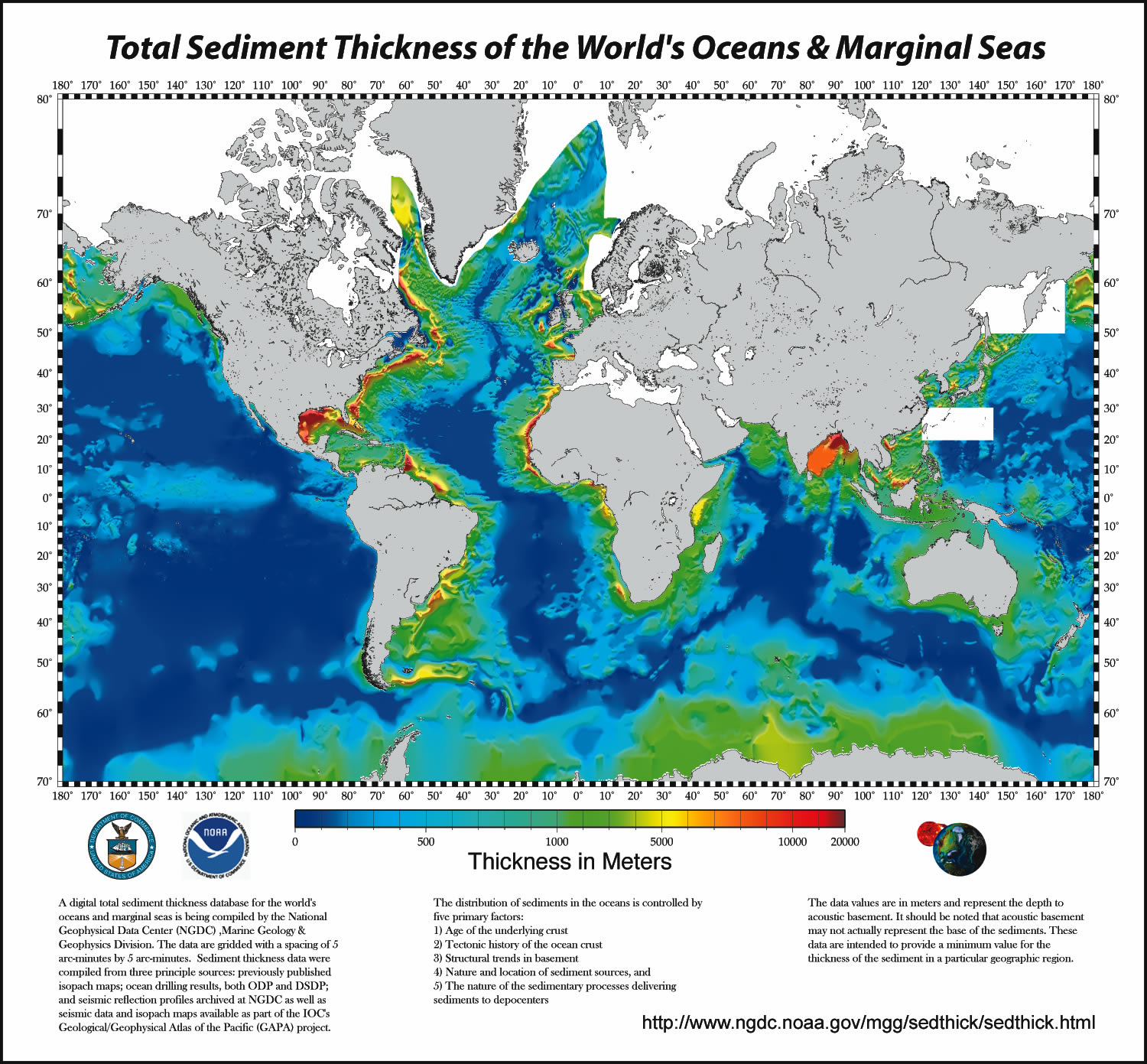
: Variations in Marine Sediment Thickness
Sediments are particles of organic or inorganic origin that accumulate in loose form in depositional environments such as lake or ocean bottoms. Marine sediments, the central focus of this week's investigations, have a variety of sources and exhibit a wide range of composition, size, and shape. Marine sediments settle to the ocean floor as unconsolidated accumulations but ultimately may be converted to solid sedimentary rock via compaction and cementation. The pattern of variations in marine sediment thickness on the ocean floor confirms some basic understandings regarding marine geological processes.
Go to the DataStreme Ocean homepage and under "Geological," click on "Sediment Thickness." This map of marine sediment thickness in the ocean basins was compiled by the National Geophysical Data Center (NGDC), Marine Geology and Geophysics Division primarily based on existing maps, ocean drilling, and seismic reflection profiles. Sediment thickness is color-coded in meters from violet (thinnest) to red (thickest). Many factors account for the variation in the thickness of marine sediment deposits including type and location of sediment sources, sediment transport mechanisms, and the age of the underlying crust.
According to the map, sediment thickness generally increases with distance from near the central portion of an ocean basin to the continental margin. This pattern may be explained by the principal sediment source and/or the age of the underlying crust. Rivers and streams emptying into the ocean slow and diverge, releasing the bulk of their suspended sediment load in coastal environments (e.g., bays, estuaries, deltas) and onto the continental shelf. Ocean currents transport sediment along the coast. In some areas of the continental shelf, massive amounts of sediment accumulate, become unstable, and flow down the continental slope to the base of the continental rise and beyond. However, only the finer fraction of river-borne sediment is swept into the deep ocean waters. Thickening of marine sediments in the direction of the continental margin may also reflect the aging of oceanic crust with distance away from divergent (spreading) plate boundaries where new oceanic crust forms. The older the crust the longer is the period that sediment rains down on the ocean bottom and the thicker is the blanket of accumulated sediment.
The map indicates that the thickness of marine sediment deposits is greater in the continental margin along the Atlantic coast of North America than along the Pacific coast. The Atlantic coast of North America is a passive margin; that is, the continental margin is not affected significantly by tectonic processes (no plate boundary) and the principal geological processes consist of sedimentation along with erosion by ocean waves and currents. In fact, passive margins and relatively thick marine sediment deposits occur on both sides of the Atlantic. (Passive margins also occur around the Arctic Ocean and surrounding Antarctica.) On the other hand, the Pacific coast of North America is an active margin; that is, the continental margin is associated with plate boundaries and is subject to deformation by tectonic stresses. Active continental margins are relatively narrow so that sediment delivered to the coast by rivers and streams flows directly into deeper water or trenches--preventing thick accumulations of marine sediments from building in the continental margin.
Concept of the Week: Questions
- The thickness of marine sediment deposits is greater in the[(continental margins)(deep-ocean basins)].
- The thickness of marine sediment deposits generally is greater in [(active)(passive)] continental margins.
Historical Events
14 February 1779...The famous British scientific navigator, Captain James Cook, Royal Navy, was killed by natives of the Sandwich Islands on the Kona coast of what is now the state of Hawaii's Big Island. His geographic discoveries and three scientific expeditions of the Pacific made him the most famous navigator since Magellan. (Wikipedia) (Today in Science)
14 February 1840...Officers from the USS Vincennes made the first landing in Antarctica on floating ice. (Naval Historical Center)
14 February 1903...An Act of Congress (31 Stat. L., 826, 827) that created the Department of Commerce and Labor provided for the transfer of the Lighthouse Service from the Treasury Department. This allowed the Secretary of Commerce and Labor to succeed to the authority vested in the Secretary of the Treasury under the existing legislation. (USCG Historian's Office)
14 February 1912...The first diesel-powered submarine was commissioned in Groton, CT. (Wikipedia)
14 February 1954...A waterspout was observed two miles east of Baranof, AK, an unusual occurrence for Alaska, particularly in winter. Just prior to the formation of the waterspout, a "terrific wind from the south out of a bay inside Warm Springs Bay" lifted water 20 feet and looked "as if it were boiling". (Accord's Weather Guide Calendar)
15 February 1912...Fram reached latitude 78º 41' S, farthest south ever by ship. Therefore, the "Fram" became the first ship to have sailed the farthest north and the farthest south.
15 February 1954...An ocean exploration depth record of 13,287 feet (over 2,000 fathoms, or over 2-1/2 miles) was attained when Georges Houot and Pierre Willm reached the Atlantic Ocean floor off Dakar, Senegal. (Today in Science)
15 February 1982...An intense cyclone (low pressure system) off the Atlantic coast of Newfoundland capsized the Ocean Ranger, a drilling rig, killing 84 persons, and sank a Soviet freighter resulting in 33 more deaths. The cyclone produced 80-mph winds that whipped the water into waves fifty feet high. (David Ludlum)
15 February 1998...A "rogue" wave from the Pacific Ocean swept into the harbor at Port Arena, CA. This wave continued through a harbor parking lot, depositing sand, debris and logs, as well as moving thirty parked vehicles. No injuries were sustained. (Accord's Weather Guide Calendar)
16 February 1832...The HMS Beagle with Charles Darwin onboard reached St-Pauls (1ºN, 29ºW).
16 February 1993...The Haitian passenger ferry Neptune sank, sending 1,215 Haitians to their deaths. Coast Guard units participated in the search and rescue operation but found no survivors. They then assisted in recovering the bodies of the victims. (USCG Historian's Office)
17 February 1836...The HMS Beagle and Charles Darwin left Tasmania.
17 February 1867...The first ship passed through the Suez Canal. (Wikipedia)
18 February 1828...More than 100 vessels were destroyed in a storm at Gibraltar.
18 February 1846...A General order was issued by the Secretary of the US Department of Navy "on Port and Starboard," in which the term "port" replaced "larboard." (Naval Historical Center)
19 February 1473...Nicolaus Copernicus, the father of modern astronomy, was born in Torun in north central Poland. He was the first modern European scientist to propose that the Earth and other planets revolve around the Sun. (The History Channel)
19 February 1845...The Lighthouse Establishment was transferred to the Revenue Marine Bureau. Metal buoys were first put into service. They were riveted iron barrels that replaced the older wooden stave construction. (USCG Historian's Office)
19 February 1972...A vicious coastal storm dumped 10 to 20 inches of snow over interior sections of the mid-Atlantic and Northeast states and caused some of the worst coastal damage of the century in New England. Storm surges up to 4.5 ft and winds gusting over 80 mph along coastal Rhode Island, Massachusetts, New Hampshire, and Maine resulted in extensive property damage and tremendous beach erosion. Twenty-seven houses were destroyed and 3000 damaged in Massachusetts alone. (Intellicast)
19 February 1977...Using the research submersible Alvin, deep-ocean researchers John B. Corliss and John M. Elmond found an extraordinary oasis of life on the Pacific Ocean floor off the Galapagos Islands, including new types of worms, clams and crabs around geothermal hot water vents. These organisms appeared to depend upon bacteria oxidizing hydrogen sulfide contained in the volcanic gases spewing out of the hot springs. (Today in Science)
20 February 1823...English Captain James Weddell and the brig Jane reached 74º 15' S, or 940 mi (1520 km) from the South Pole. His voyage reached farther south than anyone had ventured until the 1850s, as it was 214 mi south of the latitude that Captain James Cook had sailed.
20 February 1835...While in Chile, Charles Darwin experienced a strong earthquake and shortly thereafter saw evidence of uplift in the region. From measurements, he determined that the land rose several feet, and later hypothesized that coral reefs in the Pacific could develop along margins of subsiding landmasses. (Today in Science)
20 February 1856...The John Rutledge, an American steamer that sailed from Liverpool, England for New York, hit an iceberg in the North Atlantic. Most of the 155 people on board were lost.
Return to DS Ocean Homepage
URL: DS Ocean:/news.html
Prepared by AMS DS Ocean Central Staff and Edward J. Hopkins, Ph.D., email hopkins@meteor.wisc.edu
© Copyright, 2005, The American Meteorological Society.