Weekly Ocean News
DATASTREME OCEAN WEEK FIVE: 24-28 February 2014
For Your Information
- A change in meteorological seasons -- Friday,
28 February 2014, marks the end of meteorological winter in the
Northern Hemisphere, which by convention, is the three-month interval
of December, January and February. The following day (1 March 2014)
represents the beginning of boreal meteorological spring, the three
month interval of March, April and May. At the same time, summer in the
Southern Hemisphere ends and autumn begins.
- Light in the oceans -- If you would like
information on the distribution of sunlight in the upper levels of the
ocean has an impact upon the distribution of marine life and various
processes such as photosynthesis in these layers, please read this
week's Supplemental
Information...In Greater Depth.
Ocean in the News
- Eye on the tropics --- During the last
week tropical cyclone activity was confined to the
South Indian basin as meteorological summer in the Southern hemisphere was coming toward a close. A tropical storm formed early in the week over the Mozambique Channel between Mozambique and Madagascar. This tropical storm, which was identified as Guito, quickly strengthened to a category 1 tropical cyclone on the Saffir-Simpson Scale by midweek as it traveled southward through the Mozambique Channel. By the end of the week, Cyclone Guito had moved out of the Channel and began traveling toward the south-southeast across the open waters of the western South Indian Ocean as a weakened tropical storm. By Sunday (local time), Guito was no longer a tropical cyclone. Additional information and
satellite imagery on Cyclone Guito can be found on the NASA
Hurricane Page .
- NOAA nautical charts will now use new format -- NOAA's Office of Coast Survey recently announced that following a three-month trial period, most of the nautical charts that are available to mariners and recreational boaters will be available for free as Portable Document Format (PDF) versions of the traditional nautical charts. A new interactive chart locator has been launched to allow users to select the desired chart. [NOAA News]
- Great Lakes ice cover expands -- Images obtained from several of the nation's environmental satellites last week show that the total ice cover on North America's Great Lakes has reached slightly more than 85 percent of the entire lake surface area. This ice cover far exceeds the previous winter season's 38 percent and was close to the record 94.7 percent set in 1979. One of the visible images was obtained from the sensors onboard NOAA's GOES-13 satellite in geosynchronous orbit. [NOAA Environmental Visualization Laboratory] Natural- and false-color images were also obtained by the MODIS sensors on NASA's polar-orbiting Aqua satellite. [NASA Earth Observatory]
- Two areas in the Great Lakes States selected for targeted habitat conservation efforts -- NOAA Fisheries officials during the last week announced the selection of two sites in the Great Lakes region as being the next Habitat Focus Areas under NOAA's Habitat Blueprint. One of the sites in Muskegon Lake in Michigan's Lower Peninsula and the other is the Michigan and the St. Louis River estuary in Wisconsin and Minnesota near Duluth, MN and Superior, WI. NOAA will prioritize its agency-wide resources to address habitat challenges at these two sites. [NOAA Fisheries News]
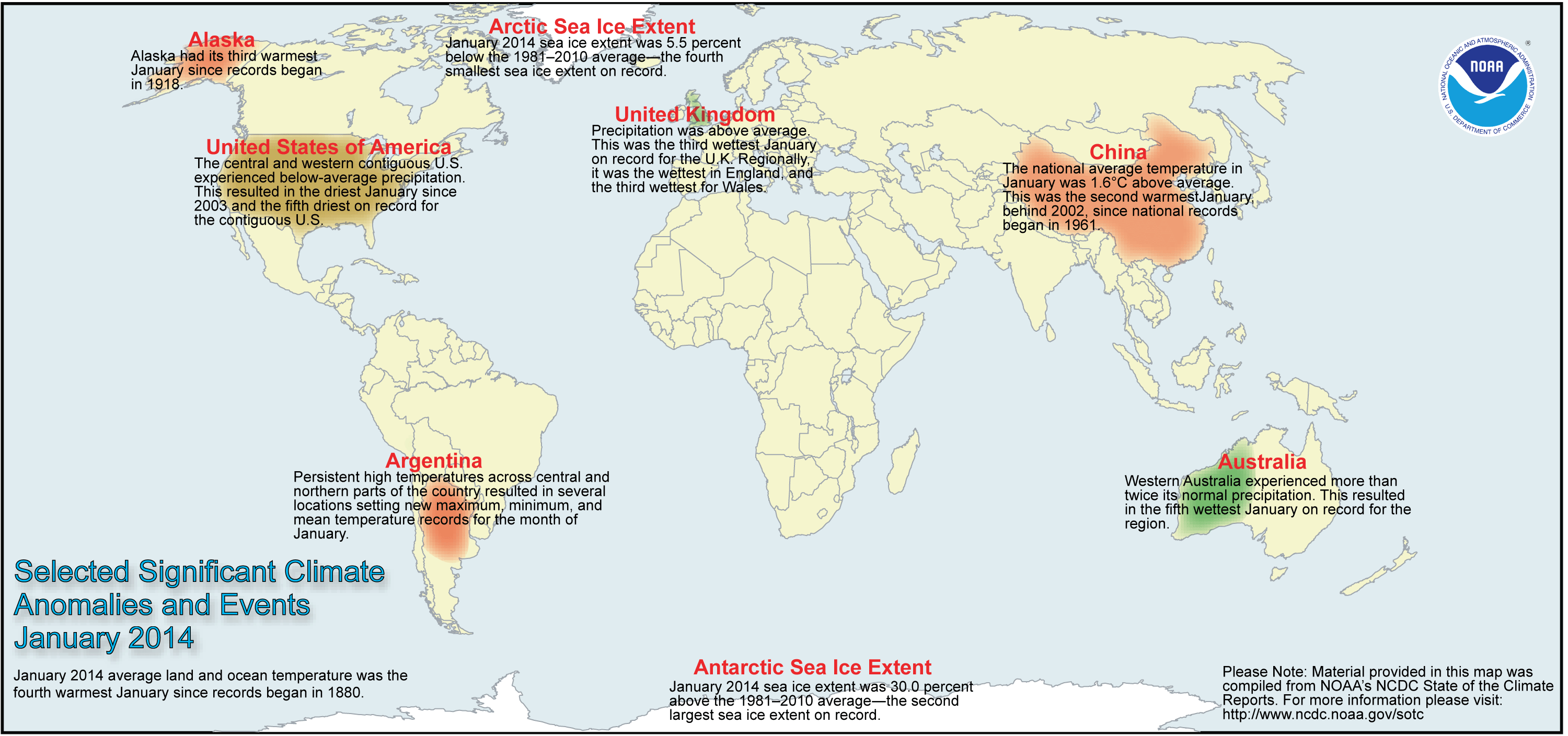
- Review of global weather
and climate for January 2014 -- Using preliminary data
collected from the global network of
surface weather stations, scientists at NOAA's National Climatic Data
Center have determined that the combined global land and ocean surface
temperature for January 2014 was 54.8 degrees Fahrenheit (or 12.7 degrees Celsius), which was the fourth highest global temperature for any
January since global climate records began in 1880. The average global
ocean surface temperature for January was the seventh highest on
record, while the global land surface temperature for January 2014 was
fourth highest. [NOAA/NCDC State of the
Climate]
According to the National Snow and Ice Data Center, the
Arctic sea ice was the fourth smallest monthly extent for any January since satellite surveillance began in 1979; the record smallest extent was in January 2011. On the other hand, Antarctic sea ice extent was the second largest January sea ice extent on record.
NCDC also provides a map showing the Global Significant Weather and Climate Events map for January 2014.
- Satellites detect a faster rate of darkening of Arctic surface -- Researchers at Scripps Institution of Oceanography have found that data collected by sensors onboard several NASA satellites indicate a "darkening" of the sea ice on the Arctic Ocean because of diminution of the reflected sunlight from the Arctic ice surfaces due to the retreat of sea ice. Using data collected by the Clouds and Earth's Radiant Energy System (CERES) instrument onboard NASA's Tropical Rainfall Measurement Mission (TRMM) satellite, Terra, Aqua and NASA-NOAA's Suomi National Polar-orbiting Partnership (Suomi NPP) satellites, the researchers found that the reduction in the albedo or reflectivity in the Arctic region was by an amount considerably larger than previously estimated. They calculated that the overall albedo of the Arctic region fell from 52 percent to 48 percent between 1979 and 2011. [NASA Earth Science News Team]
- Antarctica's Pine Island Glacier could experience current ice melt rate for decades -- A team of researchers including those at the US Department of Energy's Lawrence Livermore National Laboratory claims that the current rapid ice melt rate of the Pine Island Glacier, one of the major outlets of the West Antarctic Ice Sheet, may continue for decades, based upon analysis of transported material during a similar melting episode on the same glacier approximately 8000 years ago. Using mass spectrometry techniques, the researchers measured the concentration of beryllium-10 produced by cosmic rays in glacially transported rock. They determined the melting approximately 8000 years ago to be comparable to modern melting rates and these melt rates lasted for decades to centuries. [Lawrence Livermore National Laboratory]
- Future climate could have unstable Atlantic deep ocean circulation -- In a study conducted by researchers from Norway's Bjerknes Centre of Climate Research at the University of Bergen and their colleagues in Norway, the United States, France and the United Kingdom, conclude that Atlantic deep water formation appears to less stable than previously thought, which could mean that future changes in climate could lead to unstable deep ocean circulation in the Atlantic. The researchers based their conclusions on a reconstruction of surface ocean conditions and deep ocean circulation during the last interglacial approximately 125,000 years ago, when sudden sporadic short-lived changes in the influence of the North Atlantic waters in the deep ocean occurred. [EurekAlert!]
- Investigation made of early rise of free oxygen on planet Earth -- Researchers at Yale University, the University of California, Riverside and the California Institute of Technology report that significant concentrations of oxygen arose in Earth's early ocean and atmosphere hundreds of millions of years before the "great oxygenation event" of approximately 2.3 billion years ago. During the time prior to this event, oxygen levels appeared to have fluctuated considerably. [Yale University News]
- An All-Hazards Monitor -- This Web
portal provides the user information from NOAA on current environmental
events that may pose as hazards such as tropical weather, drought,
floods, marine weather, tsunamis, rip currents, Harmful Algal Blooms
(HABs) and coral bleaching. [NOAAWatch]
- Earthweek -- Diary of the Planet [earthweek.com] Requires Adobe Acrobat Reader.

Concept of the Week: The Ocean and the
Global Radiation Budget
The ocean is an important player in the radiational heating
and cooling of Planet Earth. For one, covering about 71% of Earth's
surface, the ocean is a primary control of how much solar radiation is
absorbed (converted to heat) at the Earth's surface. Also, the ocean is
the main source of the most important greenhouse gas (water vapor) and
is a major regulator of the concentration of atmospheric carbon dioxide
(CO2), another greenhouse gas.
On an annual average, the ocean absorbs about 92% of the solar
radiation striking its surface; the balance is reflected to space. Most
of this absorption takes place within about 200 m (650 ft) of the
surface with the depth of penetration of sunlight limited by the amount
of suspended particles and discoloration caused by dissolved
substances. On the other hand, at high latitudes multi-year pack ice
greatly reduces the amount of solar radiation absorbed by the ocean.
The snow-covered surface of sea ice absorbs only about 15% of incident
solar radiation and reflects away the rest. At present, multi-year pack
ice covers about 7% of the ocean surface with greater coverage in the
Arctic Ocean than the Southern Ocean (mostly in Antarctica's Weddell
Sea).
The atmosphere is nearly transparent to incoming solar
radiation but much less transparent to outgoing infrared (heat)
radiation. This differential transparency with wavelength is the basis
of the greenhouse effect. Certain trace gases in
the atmosphere absorb outgoing infrared and radiate some of this energy
to Earth's surface, thereby significantly elevating the planet's
surface temperature. Most water vapor, the principal greenhouse gas,
enters the atmosphere via evaporation of seawater. Carbon dioxide, a
lesser greenhouse gas, cycles into and out of the ocean depending on
the sea surface temperature and photosynthesis/respiration by marine
organisms in surface waters. Cold water can dissolve more carbon
dioxide than warm water so that carbon dioxide is absorbed from the
atmosphere where surface waters are chilled (at high latitudes and
upwelling zones) and released to the atmosphere where surface waters
are heated (at low latitudes). Photosynthetic organisms take up carbon
dioxide and all organisms release carbon dioxide via cellular
respiration.
Concept of the Week: Questions
- If the ocean's pack ice cover were to shrink, the ocean
would absorb [(more)(less)] solar radiation.
- All other factors being equal, if sea surface temperatures
were to rise, the amount of atmospheric carbon dioxide dissolved in
surface ocean waters would likely [(increase)
(decrease)].
Historical Events
- 24 February 1881...De Lesseps' Company began work on the
Panama Canal
- 25 February 1977...An oil tanker explosion west of Honolulu
spilled 31 million gallons of oil into the Pacific Ocean.
- 26 February 1935...Robert Watson-Watt demonstrated RADAR
(Radio Detection and Ranging) for the first time, using the BBC
shortwave radio transmitter to successfully detect the distance and
direction of a flying bomber during the so-called Daventry Experiment.
- 26 February 1938...The first passenger ship was equipped
with radar.
- 27 February 1949...Aerial ice observation flights by
long-range aircraft operated from Argentia, Newfoundland. An
International Ice Patrol by vessels was neither required nor
established during the 1949 season, and it was the first time that
aircraft alone conducted the ice observation service. (USCG Historian's
Office)
- 27 February 1988...A major rain event occurred across Saudi
Arabia's Foroson Islands in the Red Sea and on the adjacent mainland
around Jizon when 1.15 in. fell. The monthly average rainfall is only
0.02 in. On the following day, flash flooding south of Riyadh killed
three children. (Accord's Weather Calendar)
- 28 February 1849...Regular steamboat service to California
from the East Coast via Cape Horn arrived in San Francisco for the
first time. The SS California had left New York
Harbor on 6 October 1848 on a trip that took 4 months and 21 days.
(Wikipedia)
- 28 February 1964...A world 12-hour rainfall record was set
at Belouve, La Reunion Island in the western Indian Ocean when 52.76
inches of rain fell. World records for 9 hours and 18.5 hours were also
set with 42.79 and 66.49 inches, respectively. (Accord's Weather
Calendar) (The Weather Doctor)
- 29 February 1504...Christopher Columbus used his knowledge
of a lunar eclipse that night to convince Native Americans to provide
him with supplies. (Wikipedia)
- 1 March 1498...The Portuguese explorer, Vasco de Gama,
landed at what is now Mozambique on his way to India.
- 1 March 1854...The SS City of Glasgow left Liverpool harbor for Philadelphia and was never seen again with
480 people on board.
- 1 March 1902...The first regular light stations in Alaska
were established at Southeast Five Finger Island and at Sentinel
Island--both on the main Inside Passage between Wrangell Strait and
Skagway. (USCG Historian's Office)
- 1 March 1905...The first regular light stations in Alaska
were established. (USCG Historian's Office)
- 1 March 1927...A system of broadcasting weather reports by
radio on four lightships on the Pacific Coast was put into effect.
(USCG Historian's Office)
- 1 March 1970...US commercial whale hunting was ended.
- 1 March 1977...The United States extended its territorial
waters to 200 miles.
- 1 March 1983...A ferocious storm battered the Pacific
coast. The storm produced heavy rain and gale force winds resulting in
flooding and beach erosion and in the mountains produced up to seven
feet of snow in five days. An F2 tornado hit Los Angeles. Thirty people
were injured and 100 homes were damaged. (The Weather Channel)
(Intellicast)
Return to DataStreme
Ocean Website
Prepared by DS Ocean Central Staff and Edward J. Hopkins,
Ph.D., email hopkins@meteor.wisc.edu
© Copyright, 2014, The American Meteorological Society.