Weekly Ocean News
DATASTREME OCEAN WEEK EIGHT: 23-27 March 2015
Items of Interest:
- "World Meteorology Day" observed -- A celebration will be held on Monday,
23 March 2015 for World
Meteorology Day. This day is designated to celebrate the
anniversary of the establishment of the World Meteorological
Organization (WMO) on 23 March 1950. The WMO is an agency within the
United Nations.
This year's theme for World Meteorological Day
2015 is “Climate knowledge for climate action."
- Tsunami Awareness Week -- NOAA and the National Tsunami Hazard Mitigation Program (a partnership between NOAA, the United States Geological Survey, the Federal Emergency Management Agency, the National Science Foundation, and the 28 U.S. Coastal States, Territories, and Commonwealths) have designated this upcoming week (22-28 March 2015) as National Tsunami
Awareness Week.
Tsunami awareness training exercises will be conducted
on 25 March 2015 for the states and territories along the Pacific that is called Pacific Tsunami Exercise (PACIFEX
15) on 25 March, for the Southwest Caribbean called CARIBE WAVE/LANTEX15 and for the western North Atlantic (LANTEX15) Open houses will be held at the National Weather Service's tsunami
warning centers in Alaska and Hawaii, along with various community
activities in coastal states. The Alaska State House of Representatives has proclaimed
next Friday 27 March 2015 as Great Alaska Earthquake Remembrance Day in observance of the 51st anniversary of the series of devastating
tsunamis that struck southeastern Alaska following several earthquakes. The entire week is also Tsunami Preparedness Week in Alaska.
[Governor's
Office for State of Alaska]
Additional information is also available for last year's 50th anniversary of the Great Alaskan earthquake and tsunami of 1964. [NOAA Weather-Ready Nation]
- Marine and tropical weather statements --
This week's Supplemental
Information...In Greater Depth identifies those
National Weather Service Forecast Centers that monitor the weather,
prepare weather forecasts, and issue event-specific warnings or
advisories for marine and coastal interests. The terminology used to
identify the particular warnings, watches and advisories for marine
interests and for tropical weather events is also discussed.
Ocean in the News:
- Eye on the tropics --- During the last week several
tropical cyclones were found::
- In South Pacific basin, the major category 5 tropical cyclone (on the Saffir-Simpson Scale) Pam weakened before losing its tropical characteristics early last week as it traveled to the south-southeast after devastating the Pacific Island nation of Vanuatu during the previous weekend. Pam has been called one of the strongest cyclones every recorded in the South Pacific Ocean. After becoming an extratropical cyclone (midlatitude storm), the remnants of Pam passed near New Zealand's North Island. See the NASA Hurricane Page for additional information and satellite images on Cyclone Pam.
Tropical Storm Nathan continued on a somewhat unusual journey during the last week. After forming early in the previous week to the east of Australia's Cape York Peninsula, Nathan traveled westward before reversing course over the Coral Sea to head toward the east. However. Nathan turned toward the south and then to the west at the start of last week, intensifying to a category 2 tropical cyclone before making landfall along the eastern coast of Queensland, Australia during the second half of last week. Traveling across the Cape York Peninsula, Pam weakened to a tropical storm, but re-intensfied to a category 1 tropical cyclone this past weekend as it traveled westward over the Gulf of Carpentaria. Cyclone Pam made landfall along the coast of Australia's Northern Territory and then continued traveling toward the west-northwest near Darwin, Australia by the start of this week. Pam was expected to emerge over the South Indian Ocean basin early this week before finally weakening. The NASA Hurricane Page has satellite images and additional information on Cyclone Nathan.
A new tropical storm, identified as Reuben, formed to the southeast of Fiji over this past weekend.
Reuben was traveling toward the south-southeast and was expected to continue on this track over the next several days as it weakens to a tropical depression.
- In western North Pacific basin Tropical Storm Bavi continued to travel toward the west-northwest toward the Philippine Sea at the beginning of the week, but weakened to a tropical depression to the northwest of Yap before it dissipated to the east of the Philippine Islands by midweek. Satellite images and additional information on Tropical Storm Bavi appear on the NASA Hurricane Center.
- Land cover changes along nation's coastlines described -- The NOAA Office of Coastal Management recently issued five regional studies as part of the Coastal Change Analysis Program (C-CAP) that focus upon the changes in the land cover across areas of the nation surrounding the Great Lakes, Gulf Coast, Northeast, Southeast and West Coast from 1996 to 2010. These C-CAP reports are intended to show community officials how earlier land use decisions and changes in climate affect land cover in these coastal regions. [NOAA News]
- Increased nautical charting operations planned for the Arctic in 2015 -- NOAA officials have announced plans to increase nautical charting operations in the Arctic during 2015 in coordination with the US Coast Guard in order to update the nautical charts in the region. The NOAA-led Arctic marine corridor project will assess the safety of a potential Arctic shipping route from Unimak Island in the Aleutians through the Bering Strait to the Chukchi Sea. [NOAA News]
- New members appointed to federal Hydrographic Services Review Panel -- The NOAA Administrator, De. Kathryn Sullivan, recently appointed six new members to the Hydrographic Services Review Panel, a federal advisory committee designed to provide NOAA independent advice on improving service and products used to support navigation and coastal resilience. [NOAA News]
- Revised listing of endangered green sea turtles along Florida and Pacific coasts seen as a success story -- Late last week NOAA Fisheries and US Fish and Wildlife Service officials proposed reclassifying the green turtle under the Endangered Species Act into eleven Distinct Population Segments around the globe in order to provide more tailored conservation efforts for the different populations. Turtles originating from two breeding populations in Florida and along Mexico's Pacific Coast that are currently considered endangered would be classified as threatened because of improvements in their populations. [NOAA News] Additional information on green sea turtles is available. [NOAA Fisheries]
- Action plan to combat illegal, unreported and unregulated fishing and seafood fraud released -- The Presidential Task Force on Illegal, Unreported, and Unregulated (IUU) Fishing and Seafood Fraud recently released its action plan for implementing its final recommendations. This Task Force was co-chaired by the US Departments of Commerce and State. The plan identifies steps that federal agencies will take both domestically and internationally to implement the recommendations made late last year by the Task Force made in December 2014. [NOAA News]
- Tracking historic storms across eastern Lake Ontario -- Using funding from NOAA's Sea Grant College Program, the New York Sea Grant is creating a climatological event database of historic storms along the eastern shore of Lake Ontario that is designed to help communities assess risk projection and increase their storm event resiliency. Focus areas in this pilot project include some fragile dunes along the Lake near Oswego and a barrier island near Sodus Bay. [NOAA Sea Grant News]
- West Coast sea lions stressed by environmental changes -- Scientists with NOAA Fisheries who have been monitoring the populations of California sea lions along the West Coast of North America have found that starving sea lion pups are washing up along the beaches of southern California as female sea lions struggle to find food for their pups, while adult male sea lions are found in abundance along the coast of the Pacific Northwest. The researchers believe that environmental changes involving in weaker winds and warmer waters in the eastern North Pacific over the last year are responsible for creating stress on the sea lions, which then is reflected in the differences as to how the males and females respond to the division of family responsibilities. [NOAA Fisheries Southwest Fisheries Science Center News]
- Glacial melting sends large amounts of freshwater into Gulf of Alaska -- Researchers from Oregon State University and the University of Alaska-Fairbanks report that melting glaciers along with regional precipitation over coastal sections of southern Alaska are emptying enormous quantities of freshwater into the Gulf of Alaska. They calculate that the freshwater discharge entering the Gulf would be equivalent to that from the sixth largest coastal river in the world if it emerged as a single stream. This quantity freshwater would affect marine biology along with the temperature, salinity and ocean currents within the Gulf of Alaska. The researchers based their report upon analysis of data collected from satellites, precipitation networks and hydrological sources. [Oregon State University News]
- A warm winter in Alaska -- While many areas across eastern North America experienced an unseasonably cold and snowy 2014/15 winter, the atmospheric circulation pattern that created these conditions was also responsible for unseasonably warm and dry winter conditions across western sections of the 48 contiguous United States and across Alaska. Maps of the winter temperature departures from the long-term averages across most of Alaska were as much as 10 Fahrenheit degrees above average. In addition, the sea surface temperatures across the Gulf of Alaska, the Bering Sea and the North Pacific close to the Aleutians were above average. [NOAA Climate.gov News]
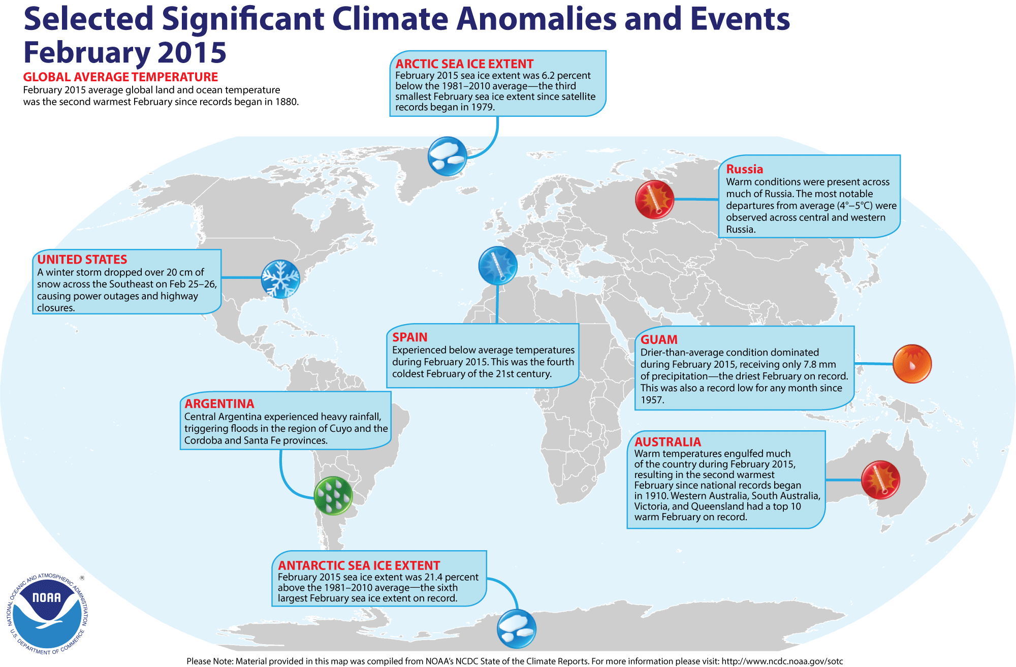
- Review of global weather
and climate for February 2015 -- Using preliminary data
collected from the global network of
surface weather stations, scientists at NOAA's National Climatic Data
Center have determined that the combined global land and ocean surface
temperature for February 2015 was 0.82 Celsius degrees above the 20th century (1901-2000) average, which was the second highest February temperature since comprehensive global climate records began in 1880. Only February 1998 was warmer. The average global
land surface temperature for February 2015 was the second highest on
record, behind February 2002. Global ocean surface temperature for this past month was the third highest in the 136-year period of record.
Furthermore, the three-months running from December 2014 through February 2015 that constitute meteorological winter in the Northern Hemisphere (and meteorological summer in the Southern Hemisphere) had the highest three-month average combined global temperature since 1880/81, with the Northern Hemisphere experiencing its warmest winter for both land and ocean and the Southern Hemisphere its fourth warmest summer. The global land surface temperature for these last three months tied the corresponding months in 2007/08 for the highest on record, while the December-February global ocean surface temperature was the third highest since 1880.
The scientists also noted that the monthly combined global (land-ocean) temperatures for nine of the last 12 months have either been the highest or second highest on record for their respective months.
[State of the
Climate/NCDC]
According to the National Snow and Ice Data Center, the
Arctic sea ice was the third smallest monthly extent for any February since satellite surveillance began in 1979. In late February 2015, Arctic sea ice extent appeared to have reached its annual maximum extent, which would represent the lowest maximum extent in the satellite-era. Sea ice extent around Antarctica was the sixth largest February sea ice extent on record.
NCDC also provides a map showing the Global Significant Weather and Climate Events map for February 2015.
- Nation's new geosynchronous environmental satellite awaits launch next year -- NOAA officials are preparing for the launch of the agency's Geostationary Operational Environmental Satellite-R Series (GOES-R) spacecraft in March 2016. This GOES-R spacecraft is intended to improve weather forecasting by obtaining near real-time weather observations more quickly from across the Western Hemisphere from its geosynchronous orbit approximately 22,000 miles above the Earth's surface. A video and a fact-sheet entitled "Top 5 Reasons Why NOAA's GOES-R Satellite Matters" provide background information on this new spacecraft. [NOAA News]
- Ocean pipes could lead to a warming climate -- In a study conducted by several scientists for the Carnegie Institute, the types of vertical ocean pipes that were proposed to move seawater to the surface so as to garner different potential climate benefits could in fact drastically increase global warming. One of the proposed strategies would have the ocean pipes facilitate direct physical cooling of the surface ocean by replacing warm surface ocean waters with colder, deeper waters. Another strategy would employ Ocean Thermal Energy Conversion (OTEC) that involves utilizing the temperature difference between deeper and shallower water to power a heat engine and produce clean electricity. [Carnegie Science News]
- An All-Hazards Monitor -- This Web portal provides the user information from NOAA's National Weather Service, FAA and FEMA on
current environmental events that may pose as hazards such as tropical
weather, fire weather, marine weather, severe weather, drought and
floods. [NOAA/NWS Daily Briefing]
- Earthweek -- Diary of the Planet [earthweek.com]
Requires Adobe Acrobat Reader.

Concept of the Week: Loss of Louisiana's
Coast
According to the Louisiana Coastal Wetlands Conservation and
Restoration Task Force, Louisiana has been losing its coastal wetlands
(bayous, marshes, and swamps) to the waters of the Gulf of Mexico at an
alarming rate of about 65 to 100 square km (25 to 38 square mi) per
year for the past several decades. This loss adversely affects
fisheries in the Gulf of Mexico and makes the coastal zone more
vulnerable to storm surges such as that produced by Hurricane Katrina
in August 2005. Since the early 1930s, the state's coastal wetlands
have shrunk by an area equivalent to the state of Delaware. According
to USGS estimates, an additional 1800 square km (700 square mi) could
be lost by mid-century. The price tag for reversing this trend,
restoring some marshes, and protecting the remaining 15,000 square km
(5800 square mi) of wetlands could top $14 billion and take decades to
complete. Many people argue that the value of Louisiana's coastal
wetlands is well worth the expense.
As much as 75% of the fish and other marine life in the
northern Gulf of Mexico depend on Louisiana's coastal wetlands. The
wetlands are a nursery for commercially important catches of shrimp,
crawfish, blue crab, and oysters. It is a food source for larger fish
including yellow fin tuna, red snapper, and swordfish. In 2003, about
three-quarters of the nation's fish and shellfish catch by weight came
from Louisiana's waters. In addition, the wetlands are a stopover for
millions of birds migrating between North and Central/South America.
Furthermore, wetlands and associated barrier islands protect the ports,
buildings, and other coastal zone structures from storm surges.
Wetlands are particularly important in buffering the levees surrounding
New Orleans, much of which is below sea level.
Many factors contribute to the loss of Louisiana's coastal
wetlands. Thousands of kilometers of pipelines transporting oil and
natural gas through the marshes plus the extensive network of
navigation channels allow saltwater to intrude the wetlands. Increased
salinity of the originally fresh or brackish waters kill wetland
grasses, shrubs, and other vegetation that anchor soil in place. The
canals also allow tidal currents to flow farther inland, accelerating
erosion of wetland soils. The most important factor, however, is the
consequence of flood control structures (levees) constructed along the
banks of the Mississippi River. Levees constrict the flow of the river
so that waters and suspended sediment discharge rapidly into the Gulf.
Deprived of a continuous input of sediments and vegetation-supporting
nutrients, existing sediments compact, wetlands subside and Gulf waters
invade the wetlands. With the anticipated continued rise in sea level
due to global climate change (discussed in Chapter 12 of your
textbook), erosion of Louisiana's coastal wetland may accelerate in the
future.
Plans to reverse the loss of Louisiana's coastal wetlands (the
Coast 2005 plan and the Louisiana Coastal Area plan) seek to restore
the structure and function of coastal wetlands. One proposal is to
breach some levees along the lower Mississippi. This partial diversion
of the Mississippi would increase the supply of sediments to the
wetlands. Closing or installing locks on some navigation canals would
reduce saltwater intrusion. In addition, dredged sediment would be used
to re-build wetlands and restore barrier islands.
Concept of the Week: Questions
- The most important factor contributing to erosion of
Louisiana's coastal wetlands is [(saltwater
intrusion)(levees along the banks
of the Mississippi River)].
- Global climate change that is accompanied by a rise in sea
level is likely to [(accelerate)(have
no effect on)] the rate of erosion of
Louisiana's coastal wetlands.
Historical Events:
- 24 March 1955...The first seagoing oil drill rig (for
drilling in over 100 feet of water) was placed in service by the U.S.
company C.G. Glasscock Drilling Co. The rig was able to drive piles
with a force of 827 tons and pull a pile with the force of 942 tons.
(Today in Science History)
- 24 March 1989...The tanker Exxon Valdez
grounded on a reef in Prince William Sound, AK, spilling 10.1 million
gallons of crude oil, resulting in the worst oil spill in U.S. history.
Coast Guard units responded and prevented the entire cargo from
spilling, cleaned up the oil which did spill, and conducted an
investigation into the causes of the accident. The spill provided the
impetus for the passage of the Oil Protection Act in 1990. (US Coast
Guard Historians Office)
- 25 March 2000...A rouge wave near Shelter Cove, CA swept a
lady from a Canadian school group into the ocean. Four members of the
group tried to rescue her, but were overcome by the waves and currents.
A fishing vessel and the US Coast Guard rescued two of the rescuers.
(Accord's Weather Guide Calendar)
- 26 March 1845...Joseph Francis of New York City patented a
corrugated sheet-iron lifeboat. (Today in Science History)
- 26 March 1946...The International Ice Patrol resumed after
being suspended during World War II. (US Coast Guard Historians Office)
- 26-28 March 2004…The first ever confirmed hurricane in the
South Atlantic Ocean, named Catarina, struck the coast of the Brazilian
states of Santa Catarina and Rio Grande do Sul with heavy rains and
winds, before dissipating over land late on the 28th. (The Weather
Doctor)
- 27 March 1513...Spanish explorer Juan Ponce de Leon sighted
Florida (and the continent of North America) for the first time,
mistaking it for another island. (Wikipedia)
- 27 March 1827...At the age of 18, Charles Darwin submitted
his first report of an original scientific discovery to the Plinian
Society in Edinburgh, Scotland. Darwin had made several discoveries
about the biology of tiny marine organisms found along the Scottish
coast. (Today in Science History)
- 27 March 1899...The first international radio transmission
between England and France was achieved by the Italian inventor G.
Marconi.
- 27 March 1930...The first US radio broadcast was made from
a ship at sea.
- 27-28 March 1964...The most powerful earthquake in US
history, the Good Friday Earthquake, rocked south central Alaska,
killing 125 people and causing $311 million in property damage,
especially to the city of Anchorage. The earthquake in Prince William
Sound, which had a magnitude of 9.2 on the Richter scale, caused some
landmasses to be thrust upward locally as high as 80 feet, while
elsewhere land sank as much as 8 feet. This earthquake and submarine
landslides also created a tsunami that also produced extensive coastal
damage. A landslide at Valdez Inlet in Alaska generated a tsunami that
reached a height of 220 feet in the inlet. A major surge wave that was
approximately 100 ft above low tide caused major damage to Whittier
(where 13 died) and other coastal communities in Alaska. The first wave
took more than 5 hours to reach the Hawaiian Islands where a 10-foot
wave was detected, while a wave that was 14.8 feet above high tide
level traveled along portions of the West Coast, reaching northern
California 4 hours after the earthquake. Nearly 10,000 people jammed
beaches at San Francisco to view the possible tsunami, but no
high-amplitude waves hit those beaches. Tsunami damage reached Crescent
City in northern California. Tens of thousands of aftershocks indicated
that the region of faulting extended a distance of about 600 miles. The
Alaska Tsunami Warning Center was established because of this disaster,
with a mission to warn Alaskan communities of the threat from tsunamis.
[See the 1964
Prince William Sound Tsunami page from the University of
Washington.] (Accord's Weather Guide Calendar) (US Coast Guard
Historians Office)
- 27 March 1980...Waves to 20 feet and winds to 58 mph in the
North Sea southwest of Stavanger, Norway led to the collapse of an oil
rig accommodation platform. The deaths of 123 of the 212 people on the
platform were the world's worst drilling catastrophe. (Accord's Weather
Guide Calendar)
- 28 March 1848...USS Supply reached the
Bay of Acre, anchoring under Mount Carmel near the village of Haifa,
during expedition to explore the Dead Sea and the River Jordan. (Naval
Historical Center)
- 28 March 1910...Henri Fabre became the first person to fly
a seaplane after taking off from a water runway at Martigues near
Marseilles, France. (Wikipedia)
- 29-31 March 1848...An ice dam at the neck of Lake Erie and
the entrance to the Niagara River between Fort Erie, ON and Buffalo, NY
caused by wind, waves and lake currents stopped flow of water over
Niagara Falls for 30 hours, commencing during the late hours of the 29th.
(Accord's Weather Guide Calendar) (The Weather Doctor)
- 29 March 1910...The world's largest oceanographic museum
was opened in Monaco through the generosity of Prince Albert I of
Monaco, a great oceanographer, statesman, and humanitarian. This
museum, a part of the Oceanographic Institute, has a grandiose facade
overlooking the Mediterranean Sea. (Today in Science History)
- 29 March 1914...The Canadian Pacific liner Empress
of Ireland, which had departed Quebec the previous day for
Liverpool, collided with the Norwegian collier Storstad in the fog along the St. Lawrence River, sinking with the loss of 1024
passengers and crew.
- 29 March 1985...The Nantucket I was
decommissioned, ending 164 years of lightship service. (USCG
Historian's Office)
Return to DataStreme
Ocean Website
Prepared by AMS DS Ocean Central Staff and Edward J. Hopkins,
Ph.D., email hopkins@meteor.wisc.edu
© Copyright, 2015, The American Meteorological Society.