Weekly Ocean News
WEEK FIVE: 22-26 February 2016
For Your Information
- Light in the oceans -- If you would like
information on the distribution of sunlight in the upper levels of the
ocean has an impact upon the distribution of marine life and various
processes such as photosynthesis in these layers, please read this
week's Supplemental
Information...In Greater Depth.
- Longing for an ocean voyage? -- Applications are now being accepted for 5 upcoming expeditions on the scientific ocean drilling vessel, JOIDES Resolution! We are looking for creative, enthusiastic, flexible educators (both classroom and informal) and outreach/science communication types – including artists, videographers, writers and more. Information and links to the application are available here: joidesresolution.org/node/453. Application deadline is 10 March.
Ocean in the News
- Eye on the tropics --- During the last week organized tropical cyclone (low
pressure systems such as tropical storms and hurricanes that form over
tropical oceans) activity remained limited to the South Indian and western South Pacific basins:
- In the South Indian Ocean Basin,
Tropical Storm Uriah intensified to a strong category 4 cyclone on the Saffir-Simpson Scale by late last week as maximum sustained surface winds reached 143 mph while traveling to the southwest and then south. Uriah weakened and dissipated over this past weekend roughly 1300 miles to the south-southeast of Diego Garcia. The NASA Hurricane Page has additional information and satellite images on Cyclone Uriah.
- In the western South Pacific basin, Cyclone Winston traveled toward the east-northeast and then toward the east during the first half of last week before reversing direction and heading to the west toward Fiji. Over this past weekend, Cyclone Winston became a major category 5 tropical cyclone on the Saffir-Simpson Scale as maximum sustained surface winds reached 185 mph with gusts to nearly 200 mph. According to Dr. Jeff Masters of Weather Underground, Winston has been rated the most powerful tropical cyclone to have developed in the Southern Hemisphere in recorded history. Winston made landfall on Fiji's island of Koro on Saturday evening (local time) at full strength as the second strongest landfall by any tropical cyclone in any ocean basin in recorded history; Super Typhoon Haiyan remains the strongest tropical cyclone with 190-mph sustained winds when it made landfall on the Philippine island of Samar in 2013.
[WunderBlog] At least one fatality was reported in Fiji as of Sunday. [CNN News] Although it weakened slightly as it moved across Fiji, Winston re-intensified as it continued toward the west. Winston was expected to turn to the south and weaken to a tropical storm midweek.
Consult the NASA Hurricane Page for satellite images and additional information on Cyclone Winston. Interestingly, Hurricane Patricia became the most intense tropical cyclone in either the North Atlantic and eastern North Pacific last fall as maximum sustained winds reached 215 mph as Patricia was located to the southwest of Manzanillo, Mexico.
[NOAA National Hurricane Center]
- Improving the nation's Hurricane Database -- Staff from NOAA's National Hurricane Center have produced a blog detailing the efforts that have been made by them and their colleagues in the Best Track Change Committee to improve and extend the HURDAT (short for HURricane DATabase), a compilation of information on the position, intensity and type of tropical cyclones in the North Atlantic basin since 1851 and in the eastern North Pacific basins since 1949. This historical hurricane database supports a wide variety of uses in the research community, the private sector and the general public. ["Inside the Eye": Blog for NOAA's National Hurricane Center]
- New study reports $7 billion involved in the nation's "ocean enterprise" -- A new US Integrated Ocean Observing System (IOOS®) report issued early last week by NOAA and its partners the Maritime Alliance and ERISS Corporation represents the first national-level assessment of the scale and scope of the "ocean enterprise," defined as the for-profit and not-for-profit firms that support ocean measurement, observation and forecasting. This report shows that the ocean enterprise currently accounts for $7 billion dollars of the US economy annually and provides up to 30,000 jobs. [NOAA National Ocean Service News]
- Monitoring Great Lakes ice cover -- An image made during the middle part of last week from the VIIRS sensor onboard the NOAA-NASA Suomi NPP satellite shows a relatively small amount of ice covering North America's Great Lakes. (Note that some of the white streamer-like features across several of the Lakes are lake-effect snow bands, produced by cold air flowing across the open and relatively warm lake surfaces.) [NOAA Environmental Visualization Laboratory] According to information furnished by NOAA's Great Lakes Environmental Research Laboratory, 23.7 percent of the Great Lakes were covered with ice at midweek this year as compared with over 80 percent during the last two relatively cold winter seasons (2013-14 and 2014-15). Lake water temperature maps are also furnished for the last three seasons. [NOAA GLERL]
- Updating Federal-state collaboration policy on Endangered Species Act implementation -- Late last week NOAA's Marine Fisheries Service and the US Fish and Wildlife Service updated their long-standing policy on the role of state fish and wildlife agencies in implementing the Endangered Species Act (ESA). [NOAA Fisheries News]
- Progress in finding bycatch solutions reported -- During the last week National Marine Fisheries Service released its "Bycatch Reduction Engineering Program: 2014 Annual Report to Congress" that details the agency's progress in preventing and reducing bycatch, which occurs occurs when fishing operations discard fish or interact with marine mammals, seabirds, or sea turtles. The report describes the projects funded through NOAA grants that focus on research on technology innovation and upon fishing practice solutions that have been undertaken. [NOAA Fisheries News]
- The "warm blog" wanes -- A comparison of satellite-derived maps of the sea surface temperature (SST) anomalies, or differences in observed and long-term average SSTs from the months of July 2015 and January 2016, show a reduction in the size and magnitude of the anomalously warm pool of water in the eastern North Pacific Ocean called the "Blob" by a University of Washington meteorologist and Washington's state climatologist. This Blob appears to have been developed initially during the winter of 2013-14 by an unusually strong and persistent ridge of high pressure in the atmosphere over the northeastern Pacific Ocean that became known as the "Ridiculously Resilient Ridge." Recently, cooler surface waters have spread the northeastern Pacific, which has resulted in an apparent breakup of the Blob as of November 2015. [NASA Earth Observatory]
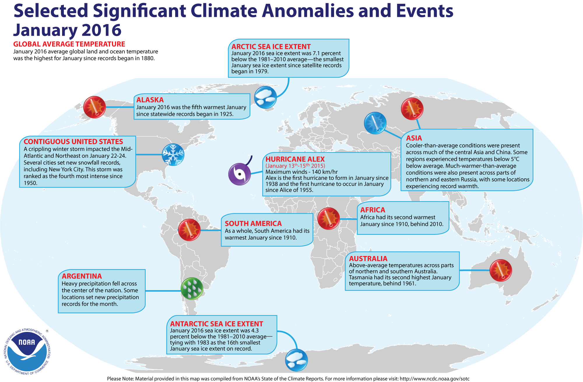
- Review of global weather
and climate for January 2016 -- Using preliminary data
collected from the global network of
surface weather stations, scientists at NOAA's National Centers for Environmental Information have determined that the combined global land and ocean surface
temperature for January 2016 was 1.87 Fahrenheit degrees (or 1.04 Celsius degrees) above the 20th-century (1901-2000) average, which makes last month the record highest global temperature for any
January since global climate records began in 1880. This reading exceeded the January 2007 temperature (1.55 Fahrenheit degrees or 0.86 Celsius degrees above the long-term average). The January 2016 ocean surface temperature was also the highest in the 137-year record, while the global land surface temperature for January 2016 was
second highest. The ocean surface remained warm despite continuation of the near-record strong El Niño event that created above average temperatures across the tropical Pacific. [NOAA/NCEI State of the
Climate]
According to the National Snow and Ice Data Center, the
extent of Arctic sea ice was the smallest monthly extent for any January since satellite surveillance began in 1979. Antarctic sea ice extent was slightly below average, tying 1983 for the 16th smallest January sea ice extent on record in the Southern Hemisphere.
The extent of the Northern Hemisphere snow cover during January 2016
was
the ninth largest for the period of record that
started in 1967. [NOAA/NCEI Global Snow & Ice]
NCEI also provides a map showing the Global Significant Weather and Climate Events map for January 2016.
- Rising seas appear to be slowed by increasing water on land -- Scientists at NASA's Jet Propulsion Laboratory (JPL) and the University of California, Irvine claim that their analysis of new measurements obtained from NASA's Gravity Recovery and Climate Experiment (GRACE) twin satellites indicates that changes in weather and climate over the past decade have caused Earth's continents to absorb and store an extra 3.2 trillion tons of liquid water in soils, lakes and underground aquifers. The sequestering of the water in the soil each year, which would be equivalent to the volume of Lake Huron, would temporarily slow the rate of sea level rise by about 20 percent, which is associated with melting ice sheets and glaciers. [NASA Press Release]
- Gigantic Antarctic ice-shelf collapse followed last Ice Age -- A team of US and Japanese oceanographers recently reported that a large 100,000-square-mile section of Antarctica's Ice Shelf appears to have broken apart and disappeared within 1500 years during a warming period after the last Ice Age. Approximately 18,000 years ago, the ice shelf covered essentially the entire Ross Basin. The researchers based their findings on measurements of the large furrows gouged by the ice and sediments on the seafloor during a 56-day cruise in 2015 of the Ross Sea. [Rice University News]
- Presence of an Ice Age warm ocean water "blob" discovered in North Atlantic -- Scientists from the Arctic University of Norway's Centre for Arctic Gas Hydrate, Environment and Climate and Norway's Aarhus University claim that a pool of warm ocean surface water appears to have existed in the North Atlantic south of Greenland during the last Ice Age. During this time ice core records indicate that Greenland experienced several abrupt climate changes. [Centre for Arctic Gas Hydrate, Environment and Climate News]
- Atmospheric free oxygen was present earlier than previously assumed -- An international team of researchers recently reported that their studies of geological data from West Greenland indicate that small levels of atmospheric free oxygen developed by 3.8 billion years ago, which would be approximately 0.7-0.8 billion years earlier than previously thought during the Great Oxidation Event (ca 2.5-2.4 billion years ago). [University of Copenhagen News]
- An All-Hazards Monitor -- This Web portal provides the user information from NOAA's National Weather Service, FAA and FEMA on
current environmental events that may pose as hazards such as tropical
weather, fire weather, marine weather, severe weather, drought and
floods. [NOAA/NWS Daily Briefing]
- Earthweek -- Diary of the Planet [earthweek.com]
Concept of the Week: The Ocean and the
Global Radiation Budget
The ocean is an important player in the radiational heating
and cooling of Planet Earth. For one, covering about 71% of Earth's
surface, the ocean is a primary control of how much solar radiation is
absorbed (converted to heat) at the Earth's surface. Also, the ocean is
the main source of the most important greenhouse gas (water vapor) and
is a major regulator of the concentration of atmospheric carbon dioxide
(CO2), another greenhouse gas.
On an annual average, the ocean absorbs about 92% of the solar
radiation striking its surface; the balance is reflected to space. Most
of this absorption takes place within about 200 m (650 ft) of the
surface with the depth of penetration of sunlight limited by the amount
of suspended particles and discoloration caused by dissolved
substances. On the other hand, at high latitudes multi-year pack ice
greatly reduces the amount of solar radiation absorbed by the ocean.
The snow-covered surface of sea ice absorbs only about 15% of incident
solar radiation and reflects away the rest. At present, multi-year pack
ice covers about 7% of the ocean surface with greater coverage in the
Arctic Ocean than the Southern Ocean (mostly in Antarctica's Weddell
Sea).
The atmosphere is nearly transparent to incoming solar
radiation but much less transparent to outgoing infrared (heat)
radiation. This differential transparency with wavelength is the basis
of the greenhouse effect. Certain trace gases in
the atmosphere absorb outgoing infrared and radiate some of this energy
to Earth's surface, thereby significantly elevating the planet's
surface temperature. Most water vapor, the principal greenhouse gas,
enters the atmosphere via evaporation of seawater. Carbon dioxide, a
lesser greenhouse gas, cycles into and out of the ocean depending on
the sea surface temperature and photosynthesis/respiration by marine
organisms in surface waters. Cold water can dissolve more carbon
dioxide than warm water so that carbon dioxide is absorbed from the
atmosphere where surface waters are chilled (at high latitudes and
upwelling zones) and released to the atmosphere where surface waters
are heated (at low latitudes). Photosynthetic organisms take up carbon
dioxide and all organisms release carbon dioxide via cellular
respiration.
Concept of the Week: Questions
- If the ocean's pack ice cover were to shrink, the ocean
would absorb [(more)(less)] solar radiation.
- All other factors being equal, if sea surface temperatures
were to rise, the amount of atmospheric carbon dioxide dissolved in
surface ocean waters would likely [(increase)
(decrease)].
Historical Events
- 22 February 1773...Extreme cold swept down the length of the Eastern Seaboard. A ship off the coast of Saint Augustine, FL reported a snowstorm severe enough to cause the loss of the ship and most of her crew. (National Weather Service files)
- 22 February 1901...A mail steamboat struck a rock and broke apart while attempting to enter the Golden Gate during heavy fog, drowning 128 people. (National Weather Service files)
- 22-26 February 1995...Cyclone Bobby slammed into the
Western Australia coast causing widespread flooding. Some areas
reported up to 12 in. of rain from the storm. (The Weather Doctor)
- 23 February 1802...A great snowstorm raged along the New
England coast producing 48 inches of snow north of Boston and 54 inches
of snow at Epping, NH. Three large (indiamen) ships from Salem were
wrecked along Cape Cod by strong winds. (David Ludlum) (Intellicast)
- 23-24 February 1995...Cyclone Bobby slammed into the Western Australia coast causing widespread flooding. Some areas reported as much as 12 inches of rain from the storm. On the 24th
Tropical Cyclone Bobby had 1-min sustained winds of 148 mph and a pressure of 930 millibars. (National Weather Service files)
- 24 February 1881...De Lesseps' Company began work on the
Panama Canal
- 25 February 1977...An oil tanker explosion west of Honolulu
spilled 31 million gallons of oil into the Pacific Ocean.
- 26 February 1935...Robert Watson-Watt demonstrated RADAR
(Radio Detection and Ranging) for the first time, using the BBC
shortwave radio transmitter to successfully detect the distance and
direction of a flying bomber during the so-called Daventry Experiment.
- 26 February 1938...The first passenger ship was equipped
with radar.
- 27 February 1949...Aerial ice observation flights by
long-range aircraft operated from Argentia, Newfoundland. An
International Ice Patrol by vessels was neither required nor
established during the 1949 season, and it was the first time that
aircraft alone conducted the ice observation service. (USCG Historian's
Office)
- 27 February 1988...A major rain event occurred across Saudi
Arabia's Foroson Islands in the Red Sea and on the adjacent mainland
around Jizon when 1.15 in. fell. The monthly average rainfall is only
0.02 in. On the following day, flash flooding south of Riyadh killed
three children. (Accord's Weather Calendar)
- 28 February 1849...Regular steamboat service to California
from the East Coast via Cape Horn arrived in San Francisco for the
first time. The SS California had left New York
Harbor on 6 October 1848 on a trip that took 4 months and 21 days.
(Wikipedia)
- 28 February 1964...A world 12-hour rainfall record was set
at Belouve, La Reunion Island in the western Indian Ocean when 52.76
inches of rain fell. World records for 9 hours and 18.5 hours were also
set with 42.79 and 66.49 inches, respectively. (Accord's Weather
Calendar) (The Weather Doctor)
Return to DataStreme
Ocean Website
Prepared by DS Ocean Central Staff and Edward J. Hopkins,
Ph.D., email hopkins@meteor.wisc.edu
© Copyright, 2015, The American Meteorological Society.