Weekly Ocean News
DATASTREME OCEAN SPRING BREAK WEEK: 7-11 March 2016
This is Break Week for the Spring 2016 offering of
the DataStreme Ocean course. This Weekly Ocean News contains new information items and historical data, but the Concept of
the Week is repeated from Week 6.
For Your Information
- Astronaut's photos of Earth & Moon serve as a great teaching tool -- The Educational Manager of the ISS (International Space Station) National Lab CASIS (Center for the Advancement of Science in Space), Dan Barstow, has announced that over 1000 photographs that astronaut Scott Kelly had taken while onboard the ISS are freely available on the web as "Scott Kelly's Amazing Earth" at WindowsOnEarth.org . These photos represent "a great resource for Earth and space science education - and for exploring climate change." A global competition to pick favorites will commence this week. Kelly returned to Earth last week after spending nearly one year onboard ISS. [WindowsOnEarth.org]
- Time change -- Daylight Saving Time
will go into effect next Sunday morning (13 March 2016) for essentially the entire
nation -- the exceptions include Arizona, Hawaii, Puerto Rico and about
18 counties in Indiana. These changes have been mandated by the U.S.
Congress in the Energy Policy Act of 2005, which extended Daylight
Saving Time across the nation, with the start on the second Sunday in
March and end on the first Sunday in November (6
November 2016). In other words, following the old adage of "spring
ahead, fall behind", you will need to turn your clocks ahead by one
hour to conform with the local time observance. Most of Canada also
observes Daylight Saving Time changes at the same time [National
Research Council Canada].
What does this time change mean to you (other than later sunsets)?
Contrary to a popular belief that has surfaced at times, the change
from Standard to Daylight Saving Time does not add an extra hour of
daylight to the day nor does it affect weather patterns. While the
weather will not change because of the time change, the times when you
will be able to obtain weather charts will now be one hour later. The
reason is that the National Weather Service operates on "Z time"
(variously called Greenwich Mean Time or Universal Coordinated Time)
which does not observe Daylight Saving Time, and the charts are still
produced and transmitted at the same Z time.
- Biomixing in ocean motion -- If you
would like information on recent findings that indicate marine
organisms contribute to motion in the ocean, please read this week's Supplemental Information…In Greater Depth.
Ocean in the News
- Eye on the tropics --- No tropical cyclone activity was reported across any of the ocean basins during the past week.
- Surf's up in Hawaii due to huge waves -- During the last two weeks, the impromptu big-wave surf competition known locally as "the Eddie" was held along Oahu's North Shore in Hawaii because of the monster breaking waves that reached heights to 60 feet along the coasts of Kauai and Oahu. On 22 February, the instrumented buoy moored offshore of Oahu's Waimea Bay recorded a record-breaking wave height. The waves were generated by ocean swell produced from two strong winter storms with hurricane-force winds that traversed the North Pacific at least 1000 miles to the north of Hawaii. The current strong El Niño event may have contributed to the strength and southern track of these Pacific storms and the strong winds. The Eddie has taken place only nine times since the inaugural competition in winter of 1985/86. [NOAA Climate.gov News]
- Deep ocean is a noisy place -- Researchers from NOAA, Oregon State University, and the US Coast Guard recently revealed their surprise at the amount of sound that was recorded by a hydrophone over a three-week span from the floor of the Pacific Ocean at a depth of 36,000 feet (7 miles). The pressure at that depth is nearly 1070 times greater than air pressure at sea level. The titanium-encased hydrophone was lowered into the Challenger Deep trough in the Mariana Trench near Micronesia to establish a baseline for ambient noise in the deepest part of the Pacific Ocean. Human-created noise appears to have increased steadily in recent decades, which could affect marine animals that use sound to communicate, navigate and feed, such as whales, dolphins and fish. [NOAA News]
- This year's hydrographic survey season begins -- NOAA's Office of Coast Survey recently launched the 2016 hydrographic survey season, which marks the nation's 182nd. The survey projects for this year, conducted from NOAA's four dedicated survey ships and by private contractors, will collect new data on water depths and new navigational hazards that will be used to update nautical charts from the nation's coastal waters and estuaries of the Atlantic and Pacific Oceans and the Gulf of Mexico in eight states. [NOAA National Ocean Service News]
- California's record sea lion pup strandings driven food changes -- According to recent NOAA Fisheries research, three years of record sea lion pup strandings along the California coast are being linked to sharp drops in high-calorie sardine and anchovy populations that mother sea lions typically use to feed their young. [NOAA News] [NOAA Fisheries Southwest Fisheries Science Center]
- Two marine sanctuaries nominated for "Best Place to See Aquatic Life" award -- Two of NOAA's National Marine Sanctuaries, California's Monterey Bay and Massachusetts' Stellwagen Bank, have been recently nominated by the national newspaper USA Today as contenders for the "Best Place To See Aquatic Life," which is part of the newspaper's latest 10Best Reader's Choice travel award contest. Both sanctuaries are considered as spectacular places to view humpback whales and other marine life. Voting for this award is open through the morning on the last Monday in March. [NOAA National Marine Sanctuaries News]
- NOAA seeks assistance solving mystery surrounding Civil War warship -- NOAA's Office of National Marine Sanctuaries' Maritime Heritage Program along with its partners are attempting to document the remains of the USS Hatteras a Civil War warship that sank during a battle with the Confederate raider, CSS Alabama, 20 miles offshore of Galveston, TX in January 1863. The remains of the Hatteras have been found in the waters of the Gulf of Mexico in Flower Garden Banks National Marine Sanctuary. Two African-American crew members lost their lives when the ship sank and NOAA is needing help identifying those men. [NOAA National Marine Sanctuaries News]
- Importance of an essential part of the Magnuson-Stevens Act addressed -- Pat Montanio, Director of Habitat Conservation for NOAA Fisheries, recently wrote a message observing the 20th anniversary of the implantation of the habitat protection called the "Essential Fish Habitat (EFH) Program" that represents a revision of the original Magnuson-Stevens Act, which coincidently celebrates its 40th anniversary. She noted that the EFH has provided a foundation for productive fisheries and resilient coastal communities. [NOAA Fisheries News]
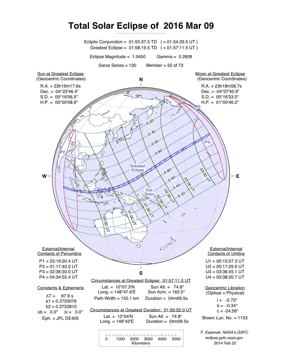
- A quick view of the faint solar atmosphere during the upcoming total solar eclipse -- Scientists from NASA's Goddard Space Flight Center plan on taking 59 several-second photographic exposures of the outer atmosphere of the Sun from Indonesia using a special polarization camera in just over three minutes during the upcoming total solar eclipse. The faint sections of the Sun's atmosphere, including the inner solar corona, should become visible when the Moon obscures the Sun for several minutes this week. [NASA Goddard Space Flight Center]
The total solar eclipse should be visible along a path extending from the eastern Indian Ocean across the Indonesia (including Sumatra, Borneo and Sulawesi) and then eastward across the Pacific Ocean to a point to the north of the Hawaiian Islands. A partial solar eclipse would be seen by people in northern and western Australia, Oceania, southeastern and eastern Asia (the Indochina Peninsula, eastern China and Japan), Hawaii and southwestern Alaska. The eclipse will begin at 2319Z on 8 March 2016, reaching a maximum at 0159Z on 9 March 2016. Totality should last for slightly more than four minutes. The NASA Eclipse Web Site has more particulars and maps of this solar eclipse.
- Satellite detects movement of Antarctic iceberg -- A pair of images obtained from data collected by the MODIS (Moderate Resolution Imaging Spectroradiometer) sensor onboard NASA's Aqua satellite documents the movement of Iceberg B-09B that had blocked a bay in East Antarctica for more than five years. One of the MODIS images was taken in February 2013, while the other image was from several weeks ago. [NASA Earth Observatory]
- Shifting winds during current El Niño monitored from space -- Scientists have been monitoring near surface wind data (both speed and direction) over the Pacific Ocean collected by NASA's RapidScat scatterometer instrument onboard the International Space Station (ISS) during the last year, which is coincidental with the development of a major El Niño event that appears to be peaking. Anomalous winds from the west have intensified during the last year over the equatorial western Pacific with a weakening over the eastern waters, which is typical of an El Niño event. Other changes in winds across the northern sections of the basin can be attributed to the teleconnections associated with this event. [NASA Earth Observatory]
- An All-Hazards Monitor -- This Web portal provides the user information from NOAA's National Weather Service, FAA and FEMA on
current environmental events that may pose as hazards such as tropical
weather, fire weather, marine weather, severe weather, drought and
floods. [NOAA/NWS Daily Briefing]
- Earthweek -- Diary of the Planet [earthweek.com]
This Concept of the Week is repeated from Week 6.
Concept of the Week: Abyssal Storms
Until recently, ocean scientists thought of the deep ocean
abyss as a dark and cold, but serene place where small particles rained
gently onto the ocean floor. However, instruments lowered to the sea
floor to measure ocean motion or currents and resulting mobilization of
bottom sediments detected a much more active environment. Scientists
found that bottom currents and abyssal storms occasionally scour the
ocean bottom, generating moving clouds of suspended sediment. A surface
current of 5 knots (250 cm/sec) is considered relatively strong. A
bottom current of 1 knot (50 cm/sec) is ripping. Although this may be
called an abyssal storm, the water motion pales by comparison to wind
speeds in atmospheric storms.
Abyssal currents and storms apparently derive their energy
from surface ocean currents. Wind-driven surface ocean currents flow
about the margins of the ocean basins as gyres centered near 30 degrees
latitude. (Refer to Figure 6.6, page 152, in your textbook.) Viewed
from above, these subtropical gyres rotate
clockwise in the Northern Hemisphere and counterclockwise in the
Southern Hemisphere. For reasons given in Chapter 6 of your textbook
and this week's Supplemental Information, surface
currents flow faster, are narrower, and extend to greater depths on the
western arm of the gyres. These are known as western boundary
currents and include, for example, the Gulf Stream of the
North Atlantic basin. Abyssal currents are also most vigorous on the
western side of the ocean basins, moving along the base of the
continental rise, which is on the order of several kilometers deep.
Abyssal storms may be linked to or may actually be eddies (rings)
that occasionally break off from the main current of the Gulf Stream
(and other western boundary currents). During an abyssal storm, the
eddy or ring may actually reach to the bottom of the ocean where the
velocity of a bottom current increases ten-fold to about 1.5 km (1 mi)
per hr. While that is an unimpressive wind speed, water is much denser
than air so that its erosive and sediment-transport capacity is
significant even at 1.5 km per hr. At this higher speed, the suspended
sediment load in the bottom current increases by a factor of ten.
Abyssal storms scour the sea floor leaving behind long furrows in the
sediment. After a few days to a few weeks, the current weakens or the
eddy (ring) is reabsorbed into the main surface circulation and the
suspended load settles to the ocean floor. In this way, abyssal storms
can transport tons of sediment long distances, disrupting the orderly
sequence of layers of deep-sea sediments. Scientists must take this
disruption into account when interpreting the environmental
significance of deep-sea sediment cores.
Concept of the Week: Questions
- In the subtropical ocean gyres, boundary currents flow
faster on the [(western)(eastern)] side of an ocean basin.
- Currents in an abyssal storm erode, transport, and
redeposit sediments that have accumulated on the [(continental
shelf)(deep ocean bottom)].
Historical Events
- 7 March 1778...Captain James Cook first sighted the Oregon
coast, at Yaquina Bay near present day Newport.
- 7
March 1932...A severe coastal storm set barometric pressure records
from Virginia to New England. Block Island, RI reported a barometric
pressure reading of 955.0 millibars (28.20 inches of mercury). (David
Ludlum)
- 7 March 1962... A powerful nor'easter lingered just off the mid-Atlantic coast for three days, resulting in severe damage along the ocean shore of the Delmarva Peninsula. Forty people were killed, and the few homesteads that were on the outer islands were destroyed. (National Weather Service files)
- 9 March 1454...Amerigo Vespucci, the Italian
navigator, was born in Florence, Italy. The North and South American
continents were named in his honor by Matthias Ringmann, a German
mapmaker.
- 9 March 1995...The Canadian Navy arrested a Spanish trawler
for illegally fishing off Newfoundland.
- 10
March 1496...Christopher Columbus concluded his second visit to the
Western Hemisphere when he left Hispaniola for Spain. (Wikipedia)
- 10 March 1849...Abraham Lincoln applied for a patent for a
device to lift vessels over shoals by means of inflated cylinders.
- 11 March 2002...The National Ice Center reported that
satellite images indicated that an iceberg with an area larger than the
state of Delaware had calved from the Thwaites Ice Tongue, a region of
snow and glacial ice extending from the Antarctic mainland into the
South Amundsen Sea (Accord's Weather Guide Calendar)
- 13-15 March 1952...The world's 5-day rainfall record was
set when a tropical cyclone produced 151.73 inches rain at Cilos,
Reunion Island in the Indian Ocean. The 73.62 inches that fell in a
24-hour period (15th-16th)
set the world's 24-hour rainfall record. (Accord's Weather Calendar)
Return to DataStreme Ocean's RealTime Ocean Portal
Prepared by DS Ocean Central Staff and Edward J. Hopkins,
Ph.D.,
email hopkins@aos.wisc.edu
© Copyright, 2016, The American Meteorological Society.