Weekly Ocean News
WEEK FIVE: 27 February-3 March 2017
For Your Information
- Celebrating heritage in National Marine Sanctuaries -- The NOAA National Marine Sanctuaries program is conducting Heritage Month Series through 2017. Since February is Black History Month, a feature has been posted entitled "For I Knew a Ship from Stem to Stern" that honors African Americans who have been involved in the nation's maritime heritage, including the famous 19th century Frederick Douglass who worked as a caulker in the Baltimore shipyard and wrote the words used in the title.
[NOAA National Marine Sanctuaries News]
- A change in meteorological seasons -- Tuesday,
28 February 2017, marks the end of meteorological winter in the
Northern Hemisphere, which by convention, is the three-month interval
of December, January and February. The following day (1 March 2017)
represents the beginning of boreal meteorological spring, the three
month interval of March, April and May. At the same time, summer in the
Southern Hemisphere ends and autumn begins.
- Leap years and calendars -- This year (2017) is considered a "normal" year with 365 days. Last year (2016) was a leap year with 366 days, with one additional day inserted at the end of February. Since the Earth completes one orbit around the Sun in
365.2422 days, calendars based upon integer days must be adjusted every
few years so that recognizable events, such as the occurrence of the
vernal equinox, do not progress through the year. In the first century
BC the Julian calendar was developed by Julius Caesar who decreed a
calendrical reform with a 365-day year that involved the inclusion of
an extra day to the end of February (the last month of the old Roman
year). However, over several centuries, the timing of the vernal equinox (and the Christian celebration of Easter) crept earlier by roughly 10 days. To correct this inconsistency, an additional reform was instituted by Pope Gregory
XIII in 1572 that included the requirement that only those centurial
years divisible evenly by 400 would be leap years, while the other
centurial years (e.g., 1800 and 1900) would not.
The National Centers for Environmental Information (formerly National Climatic Data Center) recommends that the climate normals
for 28 February be used also for 29 February in a leap year.
- Light in the oceans -- If you would like
information on the distribution of sunlight in the upper levels of the
ocean has an impact upon the distribution of marine life and various
processes such as photosynthesis in these layers, please read this
week's Supplemental
Information...In Greater Depth.
Ocean in the News
- Eye on the tropics --- During the last week three organized tropical cyclones (low
pressure systems such as tropical storms and hurricanes that form over
tropical oceans) developed in the activity remained western South Pacific basins. The first named tropical cyclone of the season for the basin, identified as Tropical Storm Alfred, formed from a tropical low pressure system last Monday over the coastal waters of the Gulf of Carpentaria, which is situated between Australia's Queensland and its Northern Territory. With travel toward the southeast, Albert became a remnant low pressure system as it made landfall between Borroloola and the Northern Territory/Queensland border and eventually dissipated little more than a day after formation . The NASA Hurricane Page has a satellite image and additional information on Tropical Storm Alfred.
The second named tropical cyclone that formed in the basin last week was
Tropical Storm Bart (also known as Tropical Cyclone 7P). Bart formed on Tuesday (local time) approximately 900 miles to the west-southwest of Papeete, Tahiti. Over the next day Bart traveled toward the southeast before losing its tropical characteristics and becoming an extratropical cyclone (midlatitude low pressure system). Consult the NASA Hurricane Page for satellite images and additional information on Tropical Storm Bart.
The third tropical cyclone to develop in the South Pacific last week was
Tropical Cyclone 8P, This tropical storm formed nearly 770 miles to the south-southeast of Pago Pago, American Samoa last Wednesdays. Like its two predecessors, Tropical Cyclone 8P was relatively short-lived, dissipating within two days due to strong wind shear (rapid changes in wind speed/direction over a short distance). Additional information and several satellite images are available NASA Hurricane Page for Tropical Cyclone 8P.
- Arctic sea ice extent could be a record smallest winter maximum -- NOAA scientists recently reported that that this winter season's expansion of Arctic sea ice may be one of the smallest in history. They provide an animation of weekly Arctic sea ice concentration running from the second week of September 2016 through the second week of February 2017 obtained from satellite data. Typically, the maximum winter ice extent occurs in late February or early March. After commencing with the second smallest end-of-summer extent last September, a few periods of thaw in the Arctic occurred during this winter, which helped slow ice formation. [NOAA News]
Scientists who study the Arctic are concerned with how the unprecedented weather conditions and the lowest maximum extent of Arctic sea ice on record this winter will affect other features in the Arctic ecosystem. [NOAA News] - Ice cover on Great Lakes down from recent winters --According to information furnished by NOAA's Great Lakes Environmental Research Laboratory, only 5.4 percent of the Great Lakes were covered with ice as of this past weekend, which compares with the 11.8 percent at the same time one year ago and the over 80 percent coverage during the recent two relatively cold winter seasons (2013-14 and 2014-15). Lake water temperature maps for each of the five lakes are also furnished for the last three seasons. [NOAA GLERL]
- Residents of Wisconsin's Apostle Islands concerned about a lack of lake ice -- The western Great Lakes have not had much lake ice this season because of the relatively warm winter across the Upper Midwest. Residents of Wisconsin's Madeline Island in the Apostle Islands in western Lake Superior have been inconvenienced by the lack of sufficiently thick ice that would normally support a midwinter "ice road" between Madeline Island and the community of Bayfield on the mainland. The ferry will run throughout this winter, as it has for the third time in the last six years. A decade ago, a Bayfield High School student collected 150 years of Lake Superior ice data from the records of ferry operation and a local newspaper to investigate evidence of climate change. He found that over the 150-year span the Lake Superior ice had decreased dramatically and since 1975 the ice season begun an average of 11.7 days later and ended three days earlier in every decade. A greater rise in lake temperature as compared with air temperature appears to be a contributing factor. [Minnesota Public Radio News]
- Plans for 2017 hydrographic survey projects released -- NOAA's Office of Coastal Survey recently released its plans for hydrographic survey projects for this upcoming field season. The hydrographic survey projects involve measurement of water depths and the identification of new navigation hazards in US waters in order to maintain the nation's suite of nautical charts current. Planned survey projects for 2017 are scheduled for Georgia, Florida, Texas, California, Washington and Alaska. [NOAA National Ocean Service News]
- Online tool available to explore scenarios involving sea level rise and coastal marsh health in Gulf Coast States -- A new online tool has been developed by the University of South Carolina that permits users to evaluate various cases of coastal salt marsh health using a suite of sea level rise scenarios. The tool uses the Marsh Equilibrium Model, which evaluates the relationship between a suite of physical and biological factors, and a hydrodynamic model to create a dynamic 2-dimensional marsh model. Graphics can be generated and used for presentations. Funding for this project was through the NOAA National Centers for Coastal Ocean Science's Ecological Effects of Sea Level Rise program. Although developed for five estuaries in Gulf Coast States, users can input data appropriate to any salt marsh across the nation. [NOAA National Centers for Coastal Ocean Science News]
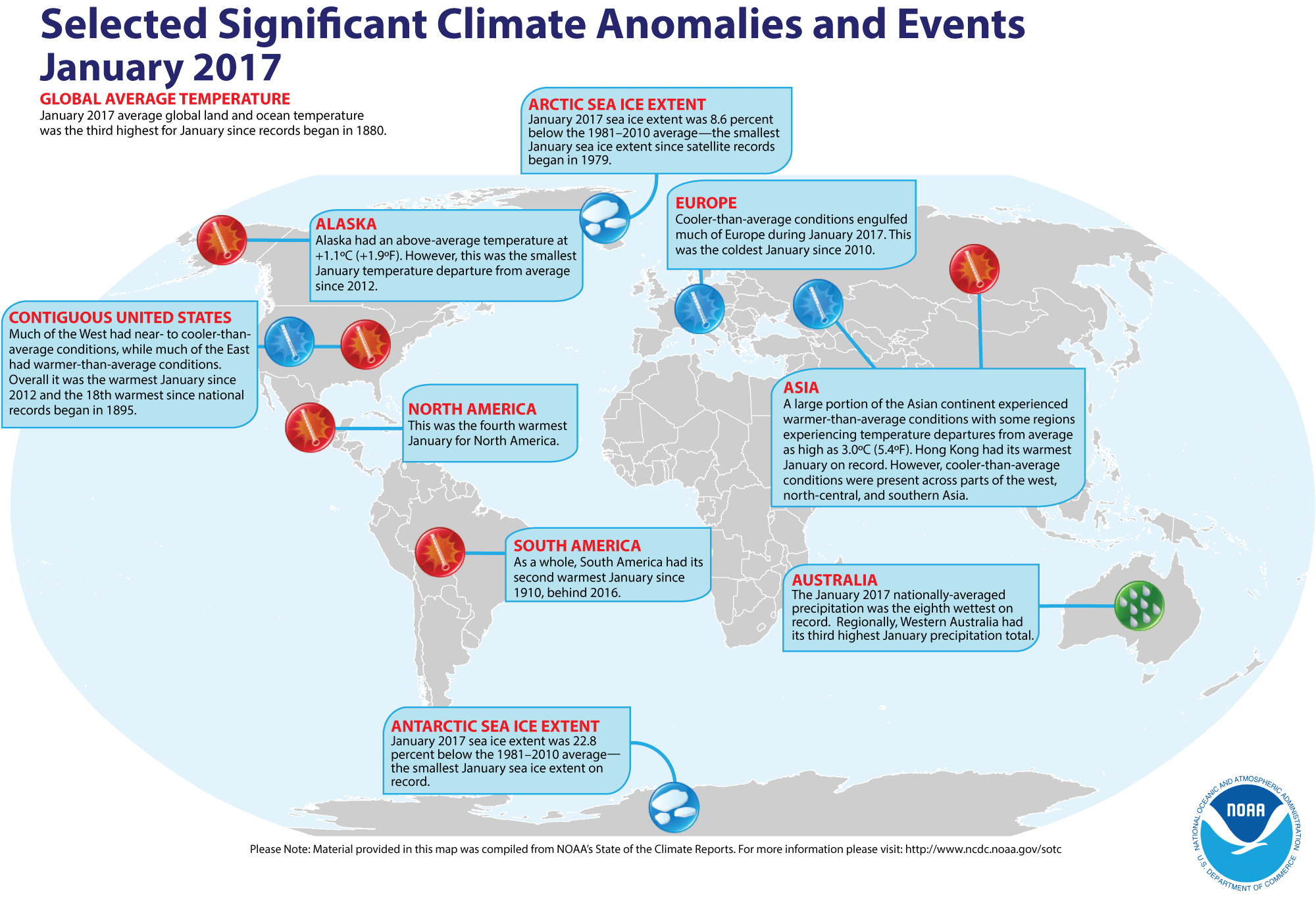
- Review of global weather
and climate for January 2017 -- Using preliminary data
collected from the global network of
surface weather stations, scientists at NOAA's National Centers for Environmental Information have determined that the combined global land and ocean surface
temperature for January 2017 was 1.58 Fahrenheit degrees (or 0.88 Celsius degrees) above the 20th-century (1901-2000) average, which makes last month the third highest global temperature for any
January since global climate records began in 1880. This reading trailed the record January 2016 temperature (1.87 Fahrenheit degrees above the 20th century average for the month) and the January 2007 temperature (1.55 Fahrenheit degrees above the long-term average). When considering land and ocean separately, the January 2017 ocean surface temperature was the second highest in the 138-year record, while the global land surface temperature for January 2017 was
third highest. [NOAA/NCEI State of the
Climate]
According to the National Snow and Ice Data Center, the
extent of Arctic sea ice was the smallest monthly extent for any January since satellite surveillance began in 1979. Antarctic sea ice extent in January also was the smallest on record in the Southern Hemisphere.
The extent of the Northern Hemisphere snow cover during January 2017
was
the sixth largest for the period of record that
started in 1967. [NOAA/NCEI Global Snow & Ice]
NCEI also provides a map showing the Global Significant Weather and Climate Events map for January 2017.
- "Spring predictability barrier" in ENSO forecasts described -- A research associate at the NOAA Pacific Marine Environmental Laboratory wrote a guest post for the ENSO blog in which he discusses what has been termed the "spring predictability barrier", where attempts to correctly predict future El Niño, La Niña or ENSO-neutral conditions in spring are difficult. He claims that forecasting a La Niña event from the sea surface temperature patterns in the eastern equatorial Pacific may be easier than forecasting a future El Niño event. [NOAA Climate.gov News]
- A case study involves a "coral bleaching story with an unknown ending" -- A case study is provided on the US Climate Resilience Toolkit that describes how people in American Samoa and the Independent State of Samoa are recognizing that changing ocean conditions are posing an increasing threat to the health and resilience of coral reefs and that they can now plan to protect these ecosystems found important to their islands. The US Climate Resilience Toolkit is a website developed by NOAA and the US Department of Energy that provides scientific tools, information, and expertise to help professionals manage their climate-related risks and opportunities, and improve their resilience to extreme events. A five step outline to resilience is provided. [US Climate Resilience Toolkit]
- Importance of riverine nutrients reaching the ocean is studied -- A team of researchers from academic research institutions in the United Kingdom, the Netherlands and Canada recently reported their findings on the amounts of nutrients in the form of dissolved nitrogen and phosphorus reaching the global oceans from the world's rivers using a new method for estimating the proportion of nutrients that reach the open ocean following biogeochemical processing along the continental shelf. They found that 75 percent of nitrogen and 80 percent of phosphorus from rivers cross the continental shelves into the open ocean. They claim that their estimates are crucial to understanding how anthropogenic activity and global climate change may affect global biogeochemical cycles. [EOS Earth & Space Science News]
- An All-Hazards Monitor -- This Web portal provides the user information from NOAA's National Weather Service, FAA and FEMA on
current environmental events that may pose as hazards such as tropical
weather, fire weather, marine weather, severe weather, drought and
floods. [NOAA/NWS Daily Briefing]
- Earthweek -- Diary of the Planet [earthweek.com]
Concept of the Week: The Ocean and the
Global Radiation Budget
The ocean is an important player in the radiational heating
and cooling of Planet Earth. For one, covering about 71% of Earth's
surface, the ocean is a primary control of how much solar radiation is
absorbed (converted to heat) at the Earth's surface. Also, the ocean is
the main source of the most important greenhouse gas (water vapor) and
is a major regulator of the concentration of atmospheric carbon dioxide
(CO2), another greenhouse gas.
On an annual average, the ocean absorbs about 92% of the solar
radiation striking its surface; the balance is reflected to space. Most
of this absorption takes place within about 200 m (650 ft) of the
surface with the depth of penetration of sunlight limited by the amount
of suspended particles and discoloration caused by dissolved
substances. On the other hand, at high latitudes multi-year pack ice
greatly reduces the amount of solar radiation absorbed by the ocean.
The snow-covered surface of sea ice absorbs only about 15% of incident
solar radiation and reflects away the rest. At present, multi-year pack
ice covers about 7% of the ocean surface with greater coverage in the
Arctic Ocean than the Southern Ocean (mostly in Antarctica's Weddell
Sea).
The atmosphere is nearly transparent to incoming solar
radiation but much less transparent to outgoing infrared (heat)
radiation. This differential transparency with wavelength is the basis
of the greenhouse effect. Certain trace gases in
the atmosphere absorb outgoing infrared and radiate some of this energy
to Earth's surface, thereby significantly elevating the planet's
surface temperature. Most water vapor, the principal greenhouse gas,
enters the atmosphere via evaporation of seawater. Carbon dioxide, a
lesser greenhouse gas, cycles into and out of the ocean depending on
the sea surface temperature and photosynthesis/respiration by marine
organisms in surface waters. Cold water can dissolve more carbon
dioxide than warm water so that carbon dioxide is absorbed from the
atmosphere where surface waters are chilled (at high latitudes and
upwelling zones) and released to the atmosphere where surface waters
are heated (at low latitudes). Photosynthetic organisms take up carbon
dioxide and all organisms release carbon dioxide via cellular
respiration.
Concept of the Week: Questions
(Place your responses on the Chapter Progress Response Form
provided in the Study Guide.)
- If the ocean's pack ice cover were to shrink, the ocean
would absorb [(more)(less)] solar radiation.
- All other factors being equal, if sea surface temperatures
were to rise, the amount of atmospheric carbon dioxide dissolved in
surface ocean waters would likely [(increase)
(decrease)].
Historical Events
- 27 February 1949...Aerial ice observation flights by
long-range aircraft operated from Argentia, Newfoundland. An
International Ice Patrol by vessels was neither required nor
established during the 1949 season, and it was the first time that
aircraft alone conducted the ice observation service. (USCG Historian's
Office)
- 27 February 1988...A major rain event occurred across Saudi
Arabia's Foroson Islands in the Red Sea and on the adjacent mainland
around Jizon when 1.15 in. fell. The monthly average rainfall is only
0.02 in. On the following day, flash flooding south of Riyadh killed
three children. (Accord's Weather Calendar)
- 27 February 2010...A magnitude 8.8 earthquake rocked Chile on this day. The earthquake triggered a tsunami, which devastated several coastal towns in south-central Chile. Tsunami warnings were issued in 53 countries. Waves caused minor damage in San Diego area and the Tohoku region of Japan. (National Weather Service files)
- 28 February 1849...Regular steamboat service to California
from the East Coast via Cape Horn arrived in San Francisco for the
first time. The SS California had left New York
Harbor on 6 October 1848 on a trip that took 4 months and 21 days.
(Wikipedia)
- 28 February 1964...A world 12-hour rainfall record was set
at Belouve, La Reunion Island in the western Indian Ocean when 52.76
inches of rain fell. World records for 9 hours and 18.5 hours were also
set with 42.79 and 66.49 inches, respectively. (Accord's Weather
Calendar) (The Weather Doctor)
- 29 February 1504...Christopher Columbus used his knowledge
of a lunar eclipse that night to convince Native Americans to provide
him with supplies. (Wikipedia)
- 1 March 1498...The Portuguese explorer, Vasco de Gama,
landed at what is now Mozambique on his way to India.
- 1 March 1854...The SS City of Glasgow left Liverpool harbor for Philadelphia and was never seen again with
480 people on board.
- 1 March 1902...The first regular light stations in Alaska
were established at Southeast Five Finger Island and at Sentinel
Island--both on the main Inside Passage between Wrangell Strait and
Skagway. (USCG Historian's Office)
- 1 March 1905...The first regular light stations in Alaska
were established. (USCG Historian's Office)
- 1 March 1927...A system of broadcasting weather reports by
radio on four lightships on the Pacific Coast was put into effect.
(USCG Historian's Office)
- 1 March 1970...US commercial whale hunting was ended.
- 1 March 1977...The United States extended its territorial
waters to 200 miles.
- 1 March 1983...A ferocious storm battered the Pacific
coast. The storm produced heavy rain and gale force winds resulting in
flooding and beach erosion and in the mountains produced up to seven
feet of snow in five days. An F2 tornado hit Los Angeles. Thirty people
were injured and 100 homes were damaged. (The Weather Channel)
(Intellicast)
- 2 March 1982...Half of Tonga in the South Pacific was rendered homeless by Tropical Cyclone Isaac after winds of 112 mph caused heavy damage. (National Weather Service files)
- 2 March 1990...Twenty two ships were trapped by ice in the worst ice jam in the Gulf of St. Lawrence in 10 years. The ice was 23 feet thick. (National Weather Service files)
- 3 March 1873...US Army Signal Corps established storm
signal service for benefit of seafaring men, at several life-saving
stations and constructed telegraph lines as original means of
communication. (USCG Historian's Office)
- 3 March 1960...The submarine USS Sargo returned to Hawaii from an Arctic cruise of 11,000 miles, of which
6,003 miles were under the polar ice, reaching the North Pole on 9
February. This cruise marked the first time that a submarine explored
the Arctic in winter. (Naval Historical Center)
- 4-5 March 1899...Tropical Cyclone Mahina (the Bathurst Bay
Hurricane) crossed Australia's Great Barrier Reef and generated
produced the highest storm surge ever recorded: 13-14.6 m (42.6-47.8 ft) surge in
Bathurst Bay. The Australian pearling fleet was destroyed, over 100
shipwrecks reported and 307 people killed, making Mahina the largest death toll of any natural disaster in Australian history. Minimum central
barometric pressure fell to an unofficial reading of estimated at 914
millibars (26.90 inches of mercury). (Accord's Weather Calendar) (The
Weather Doctor) (National Weather Service files)
- 5 March 1916...The Spanish ship the Principe de
Asturias enroute from Barcelona to Buenos Aires sank with the
loss of 445 of the 588 passengers and crew members when it struck the
jagged reefs along the Brazilian coast at Ponta Boi in dense fog.
- 5-6 March 1962...The Great Atlantic Coast Storm of 1962
caused more than $200 million in property damage from Florida to New
England. Winds along the Middle Atlantic Coast reached 70 mph raising
40-ft waves, and 42 inches of snow fell at Big Meadows, in the
mountains of Virginia--a state record. The storm caused greater
alteration of the coastline from Cape Hatteras, NC to Long Island than
any previous storm, including hurricanes. A new inlet was cut through
Hatteras Island and more than 10 miles of Outer Banks barrier dunes
were obliterated. The Virginia shoreline was rearranged by historic
tidal flooding caused by the combination of the long stretch of strong
onshore winds and the spring tides. A 3-mile long boardwalk in Ocean
City, MD was wiped out. (David Ludlum) (Intellicast)
Return to RealTime Ocean Portal
Prepared by DS Ocean Central Staff and Edward J. Hopkins,
Ph.D.,
email hopkins@aos.wisc.edu
© Copyright, 2017, The American Meteorological Society.