Weekly Ocean News
27-31 March 2017
Items of Interest:
- Tsunami Awareness Week -- National Tsunami
Awareness Week will be observed during the week of 27 -31 March 2017. California will be conducting its 2017 Tsunami Preparedness Week during this week [The TsunamiZone]
The entire week is Tsunami Preparedness Week in Alaska.
[Governor's
Office for State of Alaska]. The state government in Alaska has also established the 27th of each March to be 1964 Alaska Earthquake Remembrance Day in observance of the anniversary of the series of devastating
tsunamis that struck southeastern Alaska following several major earthquakes. Additional information is also available for the recent 50th anniversary of the Great Alaskan earthquake and tsunami of 1964. [NOAA Weather-Ready Nation]
- Worldwide GLOBE at Night 2017 Campaign is underway -- The third in the series of GLOBE at Night citizen-science campaigns for 2017 will continue through Wednesday, 29 March. GLOBE at Night is a worldwide, hands-on science and education program designed to encourage citizen-scientists worldwide to record the brightness of their night sky by matching the appearance of a constellation (Leo in the Northern Hemisphere and Canis Major in the Southern Hemisphere) with the seven magnitude/star charts of progressively fainter stars.
Activity guides are also available. The GLOBE at night program is intended to raise public awareness of the impact of light pollution.
The next series in the 2017 campaign is scheduled for 18-27 April 2017. [GLOBE at Night]
- Marine and tropical weather statements --
This week's Supplemental
Information...In Greater Depth identifies those
National Weather Service Forecast Centers that monitor the weather,
prepare weather forecasts, and issue event-specific warnings or
advisories for marine and coastal interests. The terminology used to
identify the particular warnings, watches and advisories for marine
interests and for tropical weather events is also discussed.
Ocean in the News:
- Eye on the tropics --- During the last week
tropical cyclones were found in both the South Indian Ocean basin and the western South Pacific Ocean basin as astronomical autumn has begun across the Southern Hemisphere::
- In the South Indian Ocean basin, a tropical storm developed by last Thursday approximately 130 miles east of Cocos (Keeling) Islands, which is to southwest of the Indonesian Island of Sumatra.. Over this past weekend Caleb traveled westward and intensified. See the NASA Hurricane Page for additional information and satellite images for Tropical Cyclone 12S (Caleb).
- In the western sections of the South Pacific basin, Tropical Storm Debbie (also known as 13P) developed last Friday from a low pressure system called System 91P. Over this past weekend, Debbie increased to a category 1 tropical cyclone (on the Saffir-Simpson Intensity Scale) As of Sunday, Debbie was traveling toward the west-southwest toward the eastern coast of Queensland, Australia (or Debbie). Consult the NASA Hurricane Page
for additional information an Cyclone Debbie.
- NOAA research ship to be welcomed home after a 45-month voyage -- The NOAA Ship Ronald H. Brown and its crew are to be welcomed back to their home port of Charleston, SC at a special dock side ceremony on Monday (27 March) after a three and a half-year voyage. This oceanographic research vessel traveled nearly 130,000 miles as it conducted scientific research and serviced buoys that collect a wide variety of environmental data. [NOAA News]
- New trap designs released to corral invasive lionfish is deep water -- NOAA's Office of National Marine Sanctuaries and its partners have developed and released designs for new lionfish traps that are intended to provide the first realistic means of controlling invasive deep-water lionfish populations and support the development of a lionfish fishery. Currently, fish traps are prohibited in Gulf of Mexico and South Atlantic federal waters, and some other areas, without appropriate permits. The two new trap designs, if approved for use in the U.S. or elsewhere, could give fishermen a better way to capture lionfish in deep water. [NOAA National Marine Sanctuaries News]
- Recommended Sea Scallop Research Set-Aside Awards announced for 2017-2018 --NOAA Fisheries Northeast Fisheries Science Center and the New England Fishery Management Council recently announced that 17 projects that will be funded through the Sea Scallop Research Set-Aside (RSA) Program. This research will contribute to the management of the sea scallop fishery, one of the nation's most valuable commercial fisheries. [NOAA News]
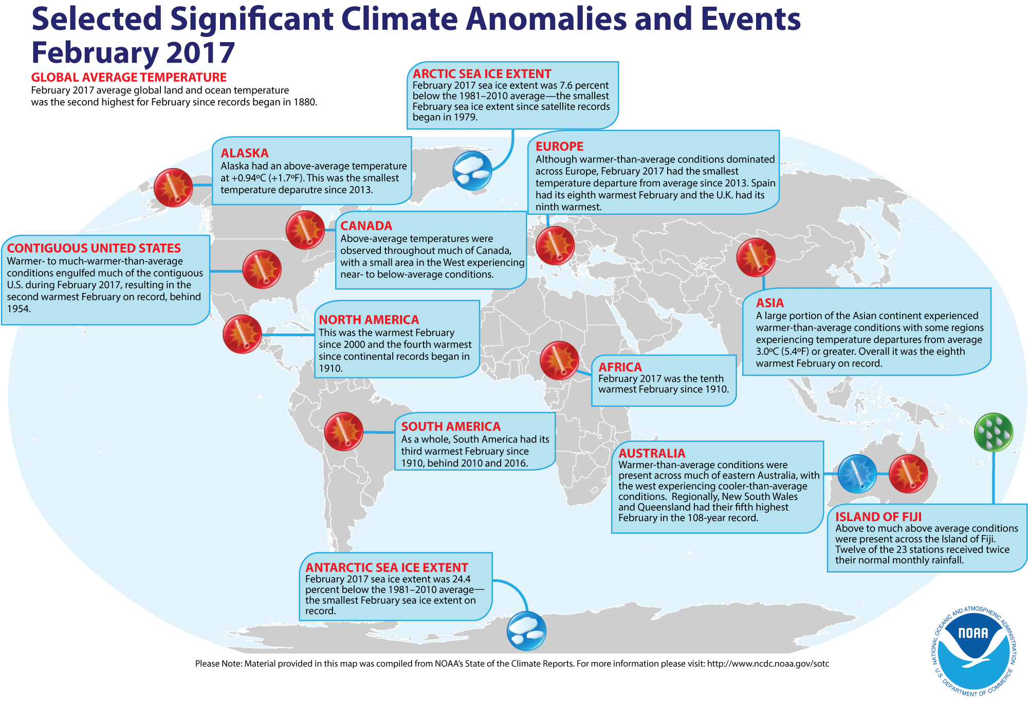
- Review of global weather
and climate for February 2017 -- Using preliminary data
collected from the global network of
surface weather stations, scientists at NOAA's National Centers for Environmental Information (NCEI) have determined that the combined global land and ocean surface
temperature for February 2017 was 0.98 Celsius degrees above the 20th century (1901-2000) average, which represents the second highest global average February temperature since comprehensive global climate records began in 1880. This February temperature departure ranks behind the record February temperature departure of 1.20 Celsius degrees above average set one year ago in February 2016. Individually, the global ocean surface temperature for this past month was the second highest in the 138-year period of record, as was the average global
land surface temperature for February 2016.
Furthermore, the three-months running from December 2016 through February 2017 that constitute meteorological winter in the Northern Hemisphere (and meteorological summer in the Southern Hemisphere) had the second highest three-month average combined global temperature for any such interval since 1880/81.
[State of the
Climate/NCEI]
NCEI also provides a map showing the Global Significant Weather and Climate Events map for February 2017.
According to the National Snow and Ice Data Center, the extent of both the
Arctic sea ice and Antarctic sea ice for February were the smallest monthly extents for any February in the two basins since satellite surveillance began in 1979. Furthermore, the Arctic sea ice extent appeared to have reached its annual maximum extent near the end of the first week of March, slightly ahead of the occurrence of typical peak winter extent in mid-March. The 14.42-million square km size would represent the lowest maximum seasonal extent in the 38-year satellite-era. [ National Snow and Ice Data Center] At the same time, the Antarctic summer minimum extent also reached a new record low. [NOAA Climate.gov News]
The extent of the Northern Hemisphere snow cover during February 2017
was
the 22nd largest for the period of record that
started in 1967. In addition, the snow cover in the Northern Hemisphere for the winter season (December 2016-February 2017) was the tenth largest on record. [NOAA/NCEI Global Snow & Ice]
- Long-term trends revealed in Arctic and Antarctic sea ice extent -- Graphs of the monthly variations in the extent of sea ice extent in both the Arctic basin and around Antarctica since 1979 when satellite surveillance began have been plotted and compared by scientists at NASA and the National Snow and Ice Data Center. A graph of the combined Arctic and Antarctic sea ice departures is provided. The time series on these graphs, which are plotted as deviations in sea ice extent, show a general decrease in Arctic sea ice extent since 1979, while a modest increase in sea ice around Antarctica until a major decrease in ice extent during the last two years. [NASA Earth Observatory]
- Explaining the wavy nature of the sea ice extent near annual maximum winter extent -- A staff member at the National Snow and Ice Data Center wrote a feature that explains why plots of sea ice extent become wavy near the time of the maximum winter ice extent in the Arctic during March and in September for maximum ice extent surrounding Antarctica. [NOAA Climate.gov News]
- Farewell to a pathfinder Earth satellite -- On this Thursday (30 March 2017) NASA will decommission its Earth Observing-1 (EO-1) satellite by powering off the satellite after 17 years in orbit. EO-1, a part of NASA's New Millennium Program, was placed in a sun-synchronous orbit in November 2000 as a means for developing and validating several instrument and spacecraft technologies. The Advanced Land Imager (ALI) on board EO-1 provided a variety of Earth data including observations of forest cover, crops, coastal waters and aerosols. The hyper-spectral instrument called Hyperion permitted scientists to see chemical constituents of Earth's surface in fine detail with hundreds of wavelengths, leading to the identification of specific minerals, the tracking of vegetation type and vigor of forests and monitor volcanic activity. [NASA Goddard Space Flight Center Feature]
- Monitoring stress on Great Barrier Reef from space -- A map was produced by NOAA's Coral Reef Watch showing various levels of heat stress in the waters to the east of Australia during the last week of February 2017 that are indicators of coral bleaching and its potential intensity in the Great Barrier Reef. Data for this stress level map were obtained from measurements of sea surface temperature made by several satellites, including the NOAA-NASA Suomi NPP satellite, the European Space Agency's Meteosat and the Japanese MTSAT. [NASA Earth Observatory]
- Ancient sediments under Dead Sea provide warnings of a dire future drought -- Scientists from Columbia University's Lamont-Doherty Earth Observatory, Israel and Spain have discovered thick layers of crystalline salt nearly 1000 feet below the bed of the Dead Sea that provide evidence of major drought in the Mideast during warm periods. The deposits were found as part of the International Continental Scientific Drilling Program (ICDP) Dead Sea Deep Drilling Project. The researchers warn that with projected warming in the future, a major drought could develop. [Lamont-Doherty Earth Observatory News]
- An All-Hazards Monitor -- This Web portal provides the user information from NOAA's National Weather Service, FAA and FEMA on
current environmental events that may pose as hazards such as tropical
weather, fire weather, marine weather, severe weather, drought and
floods. [NOAA/NWS Daily Briefing]
- Earthweek -- Diary of the Planet [earthweek.com]
Concept of the Week: Loss of Louisiana's
Coast
According to the Louisiana Coastal Wetlands Conservation and
Restoration Task Force, Louisiana has been losing its coastal wetlands
(bayous, marshes, and swamps) to the waters of the Gulf of Mexico at an
alarming rate of about 65 to 100 square km (25 to 38 square mi) per
year for the past several decades. This loss adversely affects
fisheries in the Gulf of Mexico and makes the coastal zone more
vulnerable to storm surges such as that produced by Hurricane Katrina
in August 2005. Since the early 1930s, the state's coastal wetlands
have shrunk by an area equivalent to the state of Delaware. According
to USGS estimates, an additional 1800 square km (700 square mi) could
be lost by mid-century. The price tag for reversing this trend,
restoring some marshes, and protecting the remaining 15,000 square km
(5800 square mi) of wetlands could top $14 billion and take decades to
complete. Many people argue that the value of Louisiana's coastal
wetlands is well worth the expense.
As much as 75% of the fish and other marine life in the
northern Gulf of Mexico depend on Louisiana's coastal wetlands. The
wetlands are a nursery for commercially important catches of shrimp,
crawfish, blue crab, and oysters. It is a food source for larger fish
including yellow fin tuna, red snapper, and swordfish. In 2003, about
three-quarters of the nation's fish and shellfish catch by weight came
from Louisiana's waters. In addition, the wetlands are a stopover for
millions of birds migrating between North and Central/South America.
Furthermore, wetlands and associated barrier islands protect the ports,
buildings, and other coastal zone structures from storm surges.
Wetlands are particularly important in buffering the levees surrounding
New Orleans, much of which is below sea level.
Many factors contribute to the loss of Louisiana's coastal
wetlands. Thousands of kilometers of pipelines transporting oil and
natural gas through the marshes plus the extensive network of
navigation channels allow saltwater to intrude the wetlands. Increased
salinity of the originally fresh or brackish waters kill wetland
grasses, shrubs, and other vegetation that anchor soil in place. The
canals also allow tidal currents to flow farther inland, accelerating
erosion of wetland soils. The most important factor, however, is the
consequence of flood control structures (levees) constructed along the
banks of the Mississippi River. Levees constrict the flow of the river
so that waters and suspended sediment discharge rapidly into the Gulf.
Deprived of a continuous input of sediments and vegetation-supporting
nutrients, existing sediments compact, wetlands subside and Gulf waters
invade the wetlands. With the anticipated continued rise in sea level
due to global climate change (discussed in Chapter 12 of your
textbook), erosion of Louisiana's coastal wetland may accelerate in the
future.
Plans to reverse the loss of Louisiana's coastal wetlands (the
Coast 2005 plan and the Louisiana Coastal Area plan) seek to restore
the structure and function of coastal wetlands. One proposal is to
breach some levees along the lower Mississippi. This partial diversion
of the Mississippi would increase the supply of sediments to the
wetlands. Closing or installing locks on some navigation canals would
reduce saltwater intrusion. In addition, dredged sediment would be used
to re-build wetlands and restore barrier islands.
Concept of the Week: Questions
- The most important factor contributing to erosion of
Louisiana's coastal wetlands is [(saltwater
intrusion)(levees along the banks
of the Mississippi River)].
- Global climate change that is accompanied by a rise in sea
level is likely to [(accelerate)(have
no effect on)] the rate of erosion of
Louisiana's coastal wetlands.
Historical Events:
- 27 March 1513...Spanish explorer Juan Ponce de Leon sighted
Florida (and the continent of North America) for the first time,
mistaking it for another island. (Wikipedia)
- 27 March 1827...At the age of 18, Charles Darwin submitted
his first report of an original scientific discovery to the Plinian
Society in Edinburgh, Scotland. Darwin had made several discoveries
about the biology of tiny marine organisms found along the Scottish
coast. (Today in Science History)
- 27 March 1899...The first international radio transmission
between England and France was achieved by the Italian inventor G.
Marconi.
- 27 March 1930...The first US radio broadcast was made from
a ship at sea.
- 27-28 March 1964...The most powerful earthquake in US
history, the Good Friday Earthquake, rocked south central Alaska,
killing 125 people and causing $311 million in property damage,
especially to the city of Anchorage. The earthquake in Prince William
Sound, which had a magnitude of 9.2 on the Richter scale, caused some
landmasses to be thrust upward locally as high as 80 feet, while
elsewhere land sank as much as 8 feet. This earthquake and submarine
landslides also created a tsunami that also produced extensive coastal
damage. A landslide at Valdez Inlet in Alaska generated a tsunami that
reached a height of 220 feet in the inlet. A major surge wave that was
approximately 100 ft above low tide caused major damage to Whittier
(where 13 died) and other coastal communities in Alaska. The first wave
took more than 5 hours to reach the Hawaiian Islands where a 10-foot
wave was detected, while a wave that was 14.8 feet above high tide
level traveled along portions of the West Coast, reaching northern
California 4 hours after the earthquake. Nearly 10,000 people jammed
beaches at San Francisco to view the possible tsunami, but no
high-amplitude waves hit those beaches. Tsunami damage reached Crescent
City in northern California. Tens of thousands of aftershocks indicated
that the region of faulting extended a distance of about 600 miles. The
Alaska Tsunami Warning Center was established because of this disaster,
with a mission to warn Alaskan communities of the threat from tsunamis.
(Accord's Weather Guide Calendar) (US Coast Guard
Historians Office)
- 27 March 1980...Waves to 20 feet and winds to 58 mph in the
North Sea southwest of Stavanger, Norway led to the collapse of an oil
rig accommodation platform. The deaths of 123 of the 212 people on the
platform were the world's worst drilling catastrophe. (Accord's Weather
Guide Calendar)
- 28 March 1848...USS Supply reached the
Bay of Acre, anchoring under Mount Carmel near the village of Haifa,
during expedition to explore the Dead Sea and the River Jordan. (Naval
Historical Center)
- 28 March 1910...Henri Fabre became the first person to fly
a seaplane after taking off from a water runway at Martigues near
Marseilles, France. (Wikipedia)
- 28 March 2004...The only known South Atlantic hurricane was recorded as Tropical Cyclone Catarina's winds hit 100 mph. (National Weather Service files)
- 29-31 March 1848...An ice dam at the neck of Lake Erie and
the entrance to the Niagara River between Fort Erie, ON and Buffalo, NY
caused by wind, waves and lake currents stopped flow of water over
Niagara Falls for 30 hours, commencing during the late hours of the 29th.
(Accord's Weather Guide Calendar) (The Weather Doctor)
- 29 March 1910...The world's largest oceanographic museum
was opened in Monaco through the generosity of Prince Albert I of
Monaco, a great oceanographer, statesman, and humanitarian. This
museum, a part of the Oceanographic Institute, has a grandiose facade
overlooking the Mediterranean Sea. (Today in Science History)
- 29 March 1914...The Canadian Pacific liner Empress
of Ireland, which had departed Quebec the previous day for
Liverpool, collided with the Norwegian collier Storstad in the fog along the St. Lawrence River, sinking with the loss of 1024
passengers and crew.
- 29 March 1985...The Nantucket I was
decommissioned, ending 164 years of lightship service. (USCG
Historian's Office)
- 30 March 1923...The Cunard liner Laconia arrived in New York City, becoming the first passenger ship to
circumnavigate the world, a cruise of 130 days. (Today in Science
History)
- 31 March 1932...The United States signed the Whaling
Convention at Geneva with 21 other countries. (USCG Historian's Office)
- 31 March 1995...Coast Guard Communication Area Master
Station Atlantic sent a final message by Morse code and then signed
off, officially ending more than 100 years of telegraph communications.
(USCG Historian's Office)
- 31 March 2000...The water temperature of Lake Erie at
Buffalo, NY was 39 degrees Fahrenheit on the last day of March, tying
the maximum temperature for the date with that of 1998. Ice was present
in 61 of 74 years on the 31st, but this was
third year in a row with open water. (Accord's Weather Guide Calendar)
- 1 April 1873...The British White Star steamship Atlantic sank off Nova Scotia killing 547 after striking an
underwater rock near Meagher's Island while on a voyage from Liverpool,
England to New York City. Only 413 people survived. (Wikipedia)
- 1 April 1946...The Scotch Cap Lighthouse on Unimak Island
in Alaska's Aleutian Islands was shaken by two earthquakes in a 27-minute span, then obliterated by a tsunami wave. The entire five-man
crew was killed and the lighthouse antenna (105 ft above sea level) was
washed away. Some debris was found 115 ft above sea level. The tsunami
that propagated across the Pacific Ocean was responsible for more than
165 fatalities and over $26 million in damage. Many of the casualties
were on the Hawaiian Islands, especially in Hilo on the Big Island.
This tsunami was responsible for the development of the current Pacific
Tsunami Warning System. (Accord's Weather Guide Calendar) (US Coast
Guard Historian's Office)
- 2 April 1513...Spanish explorer Juan Ponce de Leon came
ashore on the Florida coast near present-day St. Augustine and claimed
the territory for the Spanish crown. He is reported to be the first
known European to set foot in Florida. (The History Channel)
- 2 April 1958...One of the most destructive coastal storms
in years battered New England (31 March-3 April). Some beaches between
Portland, ME and Cape Cod, MA were eroded by approximately 50 ft. Miles
of sea walls and bulkheads were either breached or demolished. Many
beachfront cottages in Massachusetts, New Hampshire and Maine were
sandblasted. (Accord's Weather Guide Calendar)
- 2 April 1926...Baden-Baden, a rotor ship
invented by Anton Flettner left Hamburg, Germany on a transatlantic
crossing, arriving in New York on 29 May 1926. The ship used two 9-ft
diameter, 50-ft high cylinders, mounted vertically on the deck at the
bow and the stern for propulsion, utilizing the aerodynamic power of
the Magnus Effect, which builds air pressure behind a rotating
cylinder. (Today in Science History)
Return to RealTime Ocean Portal
Prepared by Ocean Central Staff and Edward J. Hopkins,
Ph.D.,
email hopkins@aos.wisc.edu
© Copyright, 2017, The American Meteorological Society.