WEEKLY OCEAN NEWS
28 July-1 August 2014
DataStreme Ocean will return for Fall 2014 with new Investigations files starting during Preview Week, Monday, 25 August 2014. All the current online website products will continue to be available throughout the summer break period.
Item of Interest:
- Stunning pictures of Earth from Apollo 11 -- On the occasion of last week's 45th anniversary of the first manned landing on the Moon by NASA's Apollo 11 astronauts, two photographs of Earth made by these astronauts were recently posted. These historic photographs made as the astronauts on their way to the Moon show planet Earth in a way that few humans have personally experienced. [NASA Earth Observatory]
- A celebration -- Friday, 1 August 2014, is the ancient Celtic holiday of Lammas that corresponds to one of the cross quarter days, lying nearly halfway between the summer solstice (21 June 2014) and the autumnal equinox (23 September 2014). This holiday, also known as "loaf-mass day", originally marked the first wheat harvest of the year in the British Isles. [Editor's note: The following Thursday, 7 August 2014, represents the exact halfway point between the dates of the solstice and equinox. EJH]
- In the Land of the Midnight Sun -- The sun will set at Barrow, AK early Saturday morning (2:03 AM AKDT on 2 August 2014), marking the first time in nearly 12 weeks (since 10 May 2014) that the sun has gone below the local horizon. However, the sun will remained below the horizon for 62 minutes before rising at 3:05 AM on Saturday. On each day until mid-November, the length of night will increase at Barrow. On the afternoon of 18 November 2014, the sun will set and remain below the horizon for a stretch of two months until late January 2015, when the sun will reappear above the horizon for slightly more than one hour.
Ocean in the News:
- Eye on the Tropics -- Tropical cyclone activity during the last week was found in the following ocean basins around the globe:
- In the North Atlantic basin, the second tropical depression of the 2014 Atlantic hurricane season formed early in the week nearly 1000 miles east of the Lesser Antilles. However, Tropical Depression 2 never intensified sufficiently to become a tropical storm as it traveled toward the west-northwest before dissipating by midweek. See the NASA Hurricane Page for additional information on Tropical Depression 2.
- In the eastern North Pacific basin, Tropical Storm Genevieve formed during the late week approximately 1490 miles to the east-southeast of South Point on Hawaii's Big Island. This tropical storm formed as the seventh named tropical cyclone of the eastern North Pacific basin, in a region just to the east of longitude 140 degrees West, the meridian representing the boundary between the eastern and central Pacific basins. Entering this past weekend, Tropical Storm Genevieve traveled to the west and then weakened to a tropical depression as it curved slightly to the west-northwest as it moved into the central Pacific basin. . Genevieve was expected to weaken to become a remnant low during first few days of this week, possibly bringing some unsettled weather to Hawaii. Additional information and a satellite image on Tropical Storm Genevieve can be found on the NASA Hurricane Page.
A tropical depression formed early Saturday morning approximately 700 miles to the south-southeast of Cabo San Lucas, at the southern tip of Mexico's Baja California.
This tropical depression intensified rapidly into Tropical Storm Hernan by Saturday afternoon as this system traveled to the northwest. By Sunday afternoon, Hernan intensified to become the hurricane of the 2014 hurricane season in the eastern North Pacific. Hurricane Hernan was forecast to weaken into a tropical storm and then tropical depression during the upcoming week as it continues traveling toward the northwest and west-northwest well off the coast of Baja California.
- In the western North Pacific basin, Typhoon Matmo traveled toward the northwest from the Philippine Sea at the start of last week and intensified into a category 2 typhoon (on the Saffir-Simpson Scale) before passing across Taiwan by midweek. After bringing heavy rain and strong winds to Taiwan, Typhoon Matmo made landfall along the coast of mainland China, where it weakened to a tropical storm and then dissipated. Satellite images and additional information on Typhoon Matmo can be found on the NASA Hurricane Page.
- Microwave instrument to analyze storm conditions inside tropical cyclones from Global Hawk aircraft -- NASA scientists and engineers are readying an instrument called the Hurricane Imaging Radiometer, or HIRAD, that will be flown on one of two unmanned Global Hawk aircraft during NASA's upcoming Hurricane Severe Storm Sentinel (HS3) mission. The HIRAD is a passive microwave radiometer that measures microwave radiation emitted naturally from the Earth's surface, providing data on sea surface wind speed, temperature and rain surrounding the center of a tropical cyclone where the strongest winds are typically found. The two Global Hawk aircraft will be dispatched from NASA's Wallops Flight Facility in Virginia as part of the HS3 mission that will run from 26 August through 29 September 2014. [NASA Goddard Space Flight Center]
- Internal variability in North Atlantic could affect seasonal hurricane outlooks -- Scientists at the National Center for Atmospheric Research (NCAR) and South Africa's North-West University have found that internal variability in the North Atlantic basin can make one season twice as active as another, even when El Niño and other large-scale hurricane-shaping elements remain unchanged. This internal variability involve processes that unfold without being dictated by larger-scale features. The results of simulations conducted by the researchers suggest that seasonal hurricane forecasts could be improved by conveying the amount of unavoidable uncertainty in the outlook. [NCAR/UCAR AtmosNews]
- New PORTS® system dedicated in Jacksonville, FL -- During the last week officials from NOAA and Jacksonville, FL officially dedicated a new Physical Oceanographic Real-Time System (PORTS®) along the St. Johns River in Jacksonville that is intended to increase safety of ships using the river. This PORTS® system has a variety of instruments that obtain and provide to marine users real-time information on water levels, currents, meteorological conditions, and under-bridge clearance for vessels traversing the river. The Jacksonville PORTS® is the 23rd location in the nation to use the system and is the second largest PORTS® ever established. [NOAA News]
- Innovation in US Fisheries supported by new funding -- The National Fish and Wildlife Foundation, a non-profit conservation organization created by Congress, recently announced the fourth round of grant awards designed to support innovative techniques and solutions from members of the nation's fishing industry that are aimed at improving fisheries management and supporting fishing communities across the country. For 2014, 12 projects are receiving $1.23 million and will be matched by over $1.39 million from the grantees. [NOAA Fisheries Stories]
- Coastal waters of Southeastern States invaded by Asian tiger shrimp -- Scientists from NOAA Fisheries Service and the US Geological Survey report finding the invasive and predatory Asian tiger shrimp in the waters of the Atlantic Bight and along the Gulf Coast of the United States. These tiger shrimp, which are native to Indo-Pacific, Asian, and Australian waters, may upset local ecosystems and negatively impact the US shrimping industry. [NOAA Fisheries Stories]
- Interactions seen between salmon and invasive species in Pacific Northwest fisheries Scientists with NOAA's Northwest Fisheries Science Center have found that many of the populations of Pacific salmon that are considered threatened or endangered on federal lists are now being subjected to invasive species in addition to the better known factors reducing the number of young salmon such as habitat alteration, overfishing and the barriers created by hydroelectric dams on regional rivers. The scientists found that Pacific salmon encounter at least eight documented non-native predator and competitor fish species along the Columbia River system. [NOAA Fisheries Stories]
- Swirl of plankton blooms in Baltic seen from space -- A color composite satellite image made by sensors onboard the NOAA/NASA Suomi NPP satellite last week shows a swirl of plankton blooms in the waters of the Baltic Sea off northern Europe. [NOAA Environmental Visualization Laboratory]
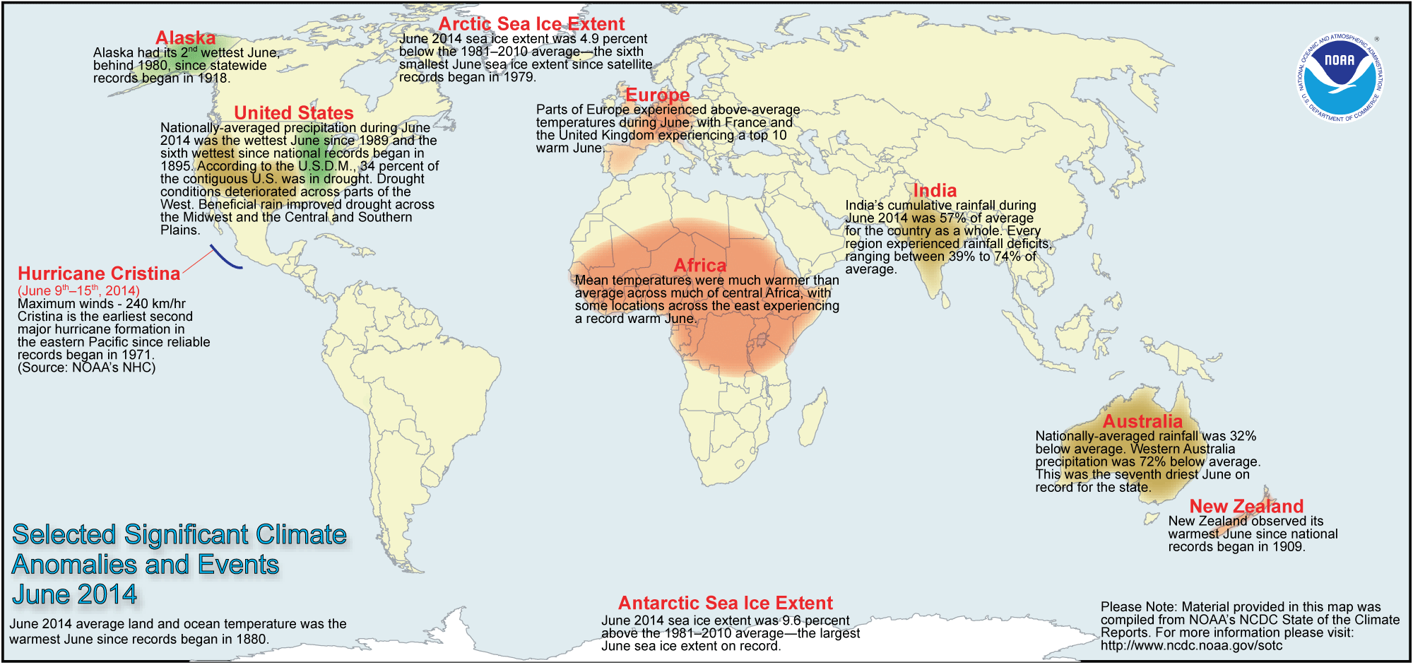
- Global temperature and ice cover for June 2014 reviewed -- Scientists at the NOAA National Climatic Data Center
recently reported on their analysis of preliminary weather data collected during the month of June 2014:
- The combined global land and ocean surface temperature for June
2014 was 61.2 degrees Fahrenheit, which was the highest for any month of June since sufficiently detailed global climate records
began in 1880. The global temperature for June 2014 was 1.30 Fahrenheit degrees above the 20th
century (1901-2000) average. This record high June temperature follows a record warm May 2014.
When considered separately,
the average land temperature for June 2014 was the seventh highest for any June since
1880, while the temperature over the oceans was the highest for
any June. In fact, this ocean temperature (expressed as a departure from average) was the highest for any month on record.
- The researchers at the National Snow and Ice Data Center noted the areal extent of the Arctic sea ice
for June 2014 was
the sixth smallest since satellite surveillance began in 1979. On the
other hand, the extent of the Antarctic sea ice was the largest
in the 36-year record. [NOAA/NCDC
State of the Climate]
- A global map of Selected Significant Climate Anomalies and Events for March 2013 is available from NCDC.
- An
All-Hazards Monitor -- This Web portal provides the user information from NOAA on
current environmental events that may pose as hazards such as tropical
weather, drought, floods, marine weather, tsunamis, rip currents,
Harmful Algal Blooms (HABs) and coral bleaching. [NOAAWatch]
- Earthweek -- Diary of the Planet [earthweek.com] Requires Adobe Acrobat Reader.

Historical Events:
- 28 July 1819...A small but intense hurricane passed over Bay Saint Louis, MS. The hurricane was considered the worst in fifty years. Few houses were left standing either at Bay Saint Louis or at Pass Christian and much of the Mississippi coast was desolate following the storm. An U.S. cutter was lost along with its thirty-nine crewmembers. The storm struck the same area that was hit 150 years later by Hurricane Camille. (David Ludlum)
- 31 July 1498...On his third voyage to the Western Hemisphere, the explorer Christopher Columbus became the first European to reach the island of Trinidad. (Wikipedia)
- 31 July 1978...A 50-yard wide waterspout came onshore at Kill Devil Hills, NC and destroyed a small house. One person died and four were hurt. Waterspouts are typically considered relatively benign. (Accord's Weather Guide Calendar)
- 1 August 1498...Christopher Columbus reached Venezuela, the first known European to visit that country. (Wikipedia)
- 1-3 August 1989...Hurricane Chantal made landfall along the Upper Texas coast about sunrise on the 1st. Chantal deluged parts of Galveston Island and southeastern Texas with 8 to 12 inches of rain. Unofficial totals ranged up to twenty inches. Winds gusted to 82 mph at Galveston, and reached 76 mph in the Houston area. Tides were 5 to 7 feet high. The hurricane claimed two lives, and caused 100 million dollars damage. The remains of Hurricane Chantal also deluged north central Texas with heavy rain. Up to 6.50 inches drenched Stephens County, and Wichita Falls reported 2.22 inches of rain in just one hour on the 2nd. (The National Weather Summary) (Storm Data)
- 1 August 2002...At the Delaware Bay buoy located 26 miles southeast of Cape May, NJ, an ocean water temperature of 83.1 degrees Fahrenheit was measured--marking the highest ocean temperature recorded at that buoy since observations began there in 1984. (Accord's Weather Guide Calendar)
- 2 August 1880...Greenwich Mean Time (GMT) was adopted officially by the British Parliament, selected because Greenwich had been the national center for time since 1675. GMT was originally set-up to aid naval navigation, but was not on land until transportation improved. GMT was adopted by the U.S. at noon on 18 Nov 1883 when the telegraph lines transmitted time signals to all major cities. Subsequently, GMT was adopted worldwide on 1 Nov 1884 when the International Meridian Conference met in Washington, DC, USA and 24 time zones were created. (Today in Science History)
- 2-3 August 1922...A typhoon hit the China Coast at Swatow on the night of the 2nd. The wind and the storm surge killed as many as 50,000 of the city's 65,000 residents. Barometric pressure at landfall had dropped to at least 932.3 millibars (27.53 inches). (Accord's Weather Guide Calendar)
- 3 August 1492...The Italian explorer Christopher Columbus, in command of three ships, embarked from the Spanish port of Palos de la Frontera on a journey westward in search of a sea route to Asia. This expedition, which reached the Bahamas near North America on 12 October, was the first of four expeditions that Columbus made to the "New World". (The History Channel)
- 3 August 1958...At 11:15 EDT, the USS Nautilus (SSN-571) was the first ship to reach the geographic North Pole submerged, traveling at a depth of approximately 500 feet from the Beaufort Sea near Point Barrow, AK on 1 August to the Greenland Sea near Spitzbergen on 5 August. (Naval Historical Center) (The History Channel)
- 3 August 1970...Hurricane Celia made landfall near Port Aransas on the Texas coast, producing wind gusts to 161 mph at Corpus Christi, and estimated wind gusts of 180 mph at Arkansas Pass. Even at Del Rio, 250 miles inland, Celia produced wind gusts to 89 mph. The hurricane was the most destructive of record along the Texas coast causing 454 million dollars damage as 8950 homes were destroyed on the Coastal Bend. Celia also claimed eleven lives and injured 466 people. (David Ludlum) (The Weather Channel) (Intellicast)
- 3-4 August 1978...The remnants of Tropical Storm Amelia produced up to 32 inches of rain on Schackelford County in Texas, an incredible amount of rain for a far-inland and non-mountainous area. A twenty-foot wall of water killed six during the evening of the 4th in Albany, resulting in 89 percent of the city being covered by water. (Accord's Weather Guide Calendar)
Return to DataStreme
Ocean Website
Prepared by AMS DS Ocean Central Staff and Edward J. Hopkins,
Ph.D., email hopkins@meteor.wisc.edu
© Copyright, 2014, The American Meteorological Society.