WEEKLY OCEAN NEWS
27-31 July 2015
DataStreme Ocean will return for Fall 2015 with new Investigations files starting during Preview Week, Monday, 24 August 2015. All the current online website products will continue to be available throughout the summer break period.
Item of Interest:
- Five "sea creatures" should be avoided at the beach -- NOAA's National Ocean Service cautions beachgoers to avoid the following five "sea creatures" that could be dangerous: jellyfish, sea urchins, lionfish, stingrays and sharks. General advice is provided for avoiding these creatures and for treating stings and bites if an encounter is made. [NOAA National Ocean Service News]
- Historic "EPIC" portrait of planet Earth obtained from afar -- NASA recently released an image that represents the first view of the entire sunlit side of Earth from one million miles away, obtained from NASA's Earth Polychromatic Imaging Camera (EPIC) mounted on the Deep Space Climate Observatory (DSCOVR) satellite. This DSCOVR spacecraft, launched in February 2015, is in orbit around Earth at the L1 Lagrange Point, which is located approximately one million miles from Earth at a point where the gravitational pull of the Sun and Earth cancel, providing a stable orbit and a continuous view of Earth. Goals of this mission include monitoring the solar wind and to measuring fluctuations in the Earth's albedo or reflectivity to solar radiation. The high-resolution multi-color image obtained from the EPIC instrument was produced by merging the data obtained from the solar radiation in the red, green and blue bands collected by the EPIC sensors. [NASA Earth Observatory]
- A celebration -- Saturday, 1 August 2015, is the ancient Celtic holiday of Lammas that corresponds to one of the cross quarter days, lying nearly halfway between the summer solstice (21 June 2015) and the autumnal equinox (23 September 2015). This holiday, also known as "loaf-mass day", originally marked the first wheat harvest of the year in the British Isles. [Editor's note: Next Friday, 7 August 2015, represents the exact halfway point between the dates of the solstice and equinox. EJH]
- In the Land of the Midnight Sun -- The sun will set at Barrow, AK early Sunday morning (2:09 AM AKDT on 2 August 2015), marking the first time in nearly 12 weeks (since 11 May 2015) that the sun has gone below the local horizon. However, the sun will remain below the horizon for 50 minutes before rising at 2:59 AM on Sunday. On each day until mid-November, the length of night will increase at Barrow. On the afternoon of 19 November 2015, the sun will set and remain below the horizon for a stretch of two months until late January 2016, when the sun will reappear above the horizon for slightly more than one hour.
Ocean in the News:
- Eye on the Tropics -- During the last week, tropical cyclone
activity continued across the Pacific basins in the Northern Hemisphere:
- In the eastern North Pacific basin,
former Hurricane Dolores weakened to a tropical depression over the previous weekend and then at the start of last week becoming a remnant low that traveled toward the north-northwest approximately 400 miles off the western coast of Mexico's Baja California Peninsula. Even after dissipating, remnants of this former category 4 hurricane (on the Saffir-Simpson Scale) continued to spread much needed rain across northwestern Mexico and into the Southwest of the US. The NASA Hurricane Page has additional information and satellite imagery on Hurricane Dolores.
Tropical Storm Felicia, the sixth named tropical cyclone of the 2015 eastern Pacific hurricane season formed during the second half of last week approximately 400 miles to the southwest of the southern tip of Baja California. Remaining as a tropical storm briefly, Tropical Depression Felicia weakened slightly as it traveled toward the northwest and then west-northwest. However, this system traveled over Socorro Island. At the end of the week Felicia became a remnant low approximately 660 miles west of Baja California. See the NASA Hurricane Page for additional details and satellite images on Tropical Storm Felicia.
- In the western North Pacific basin, Typhoon Halola continued to travel to the west-northwest last week. This typhoon had become a category 2 typhoon (on the Saffir-Simpson Scale) at the end of the previous week after it crossed the International Dateline from the central Pacific basin. Halola weakened to a tropical storm and then a depression at the start of last week before re-intensifying to a category 2 typhoon near midweek. By this past weekend Halola passed approximately 200 miles from Okinawa, Japan, as it turned toward the north. On Monday (local time), Halola was downgraded to a tropical depression as it moved across the islands of southwestern Japan. Additional information and satellite information on former Typhoon Halola can be found at NASA Hurricane Page.
Tropical Storm 12 formed late last week over the waters of the Philippine Sea just off the northeastern coast of Luzon. After strengthening slightly, this tropical storm traveled toward the east and then to the northeast away from the Philippines late in the week, before weakening and dissipating over the weekend. Consult the NASA Hurricane Page for satellite images and additional information on Tropical Storm 12.
- Funding is awarded for response to West Coast harmful algal bloom outbreak -- During the last week NOAA announced that the agency was awarding $88,000 in a grant and event response funding to the state of Washington that would be used to monitor and analyze a relatively large bloom of toxic algae that developed since May in the waters of the Pacific Ocean off the state's coast. These toxic blooms are adversely affecting both fisheries and coastal residents. [NOAA News]
- Satellite detects smoke from Arctic wildfires spreading Greenland Sea -- A true-color image made from data collected by the MODIS sensor onboard NASA's Aqua satellite in early July shows a veil of smoke that spread across the Greenland Sea, produced from the numerous wildfires that were burning across northern Canada and Alaska. This wildfire season appears to be heading for the worst in Alaska state history. [NASA Goddard Space Flight Center]
- Greenland glaciers melting faster than anticipated -- Glaciologists from the University of California, Irvine and NASA's Jet Propulsion Laboratory claim that their mapping of Greenland glaciers reveals these glaciers melting at rates faster than previously thought. The glaciers are grounded deeper below sea level than previously measured, which would allow intruding ocean water to undercut the glacier faces and cause rapid melting and a rise in global sea level. [NASA Jet Propulsion Laboratory News]
- Ability of coral reefs to protect coasts appears to be reduced by climate change -- Researchers from the US Geological Survey (USGS) and the Dutch independent institute for applied research Deltares warn that pressures exerted by changes in climate and from direct human activity may be reducing the ability of coral reefs to protect tropical islands from a variety of coastal hazards including wave attach, erosion and salinization of potable water resources. The researchers used an open source wave model to investigate how the effects on water levels, waves and wave-driven run-up for several changes in certain reef properties.
[USGS Newsroom]
- Detailed flood information may increase reliability of coastal storm impact estimates -- A new study conducted by the US Geological Survey (USGS) in cooperation with the Federal Emergency Management Agency (FEMA) analyzed how damage estimates evolve following a coastal storm. The study focused upon the impacts and total storm damage to buildings in New York State by county following Hurricane Sandy, demonstrating the need for gathering detailed storm damage data on coastal areas before and after a storm. A similar study is being undertaken for the impacts of Sandy on New Jersey. [USGS Newsroom]
- Less algae helps keep Lake Tahoe blue -- The Tahoe Environmental Research Center (TERC) of the University of California, Davis recently released its annual "Tahoe: State of the Lake Report 2015" that claims the iconic blueness of Lake Tahoe along the Nevada and California border is more strongly related to the lake's algal concentration than to its clarity. A TERC researcher created a quantitative "Blueness Index" of the lake's color from data collected by the NASA Jet Propulsion Laboratory's research buoy moored in the lake. [NASA Jet Propulsion Laboratory] and [University of California Davis]
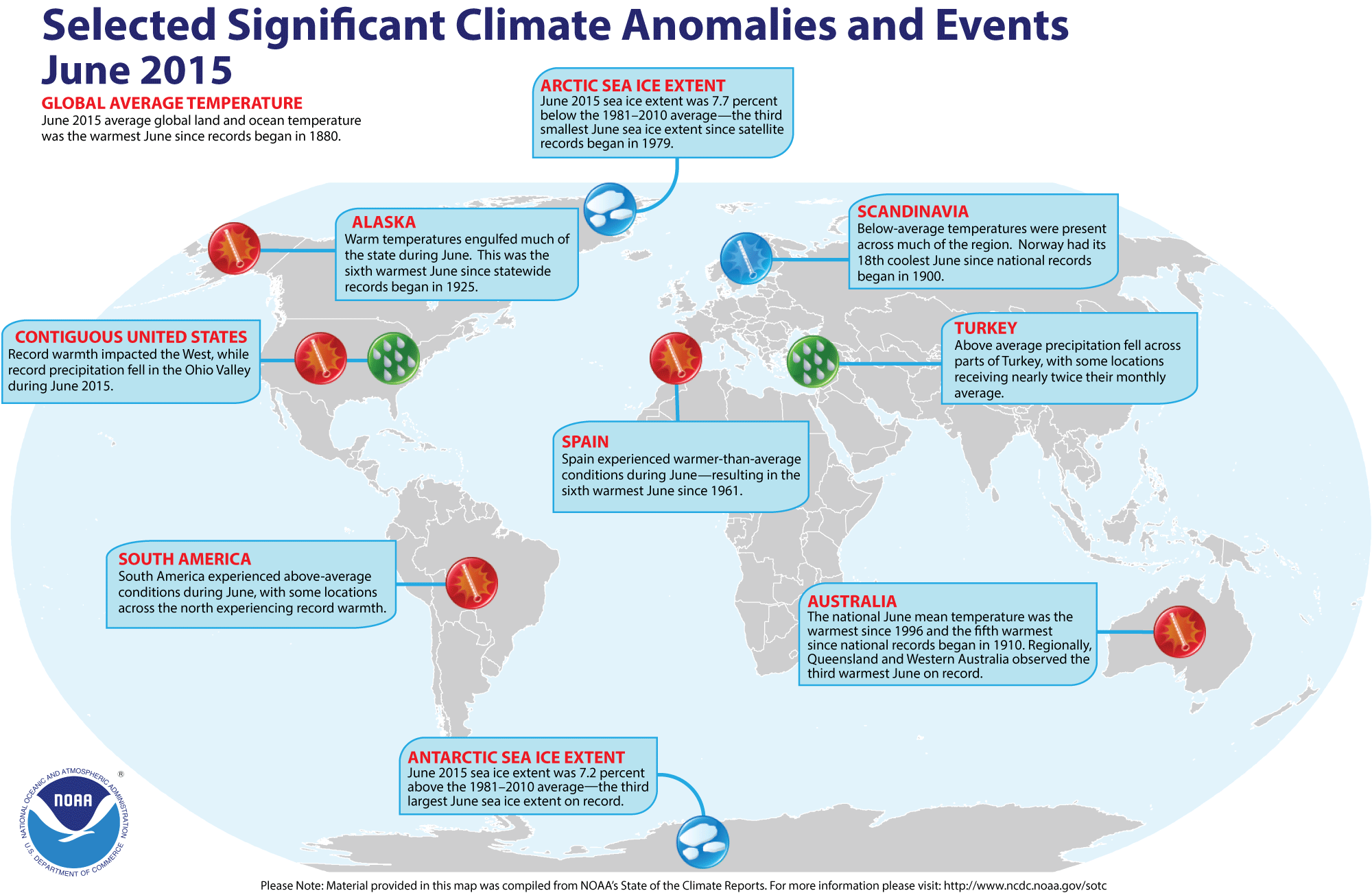
- Global temperature and ice cover for June 2015 reviewed -- Scientists at the NOAA National Centers for Environmental Information (NCEI, and formerly National Climatic Data Center)
recently reported on their analysis of preliminary weather data collected during the month of June 2015:
- The combined global land and ocean surface temperature for June
2015 was 1.58 Fahrenheit degrees above the 20th
century (1901-2000) average, which was the highest for any month of June since sufficiently detailed global climate records
began in 1880. When considered separately,
both the average land and average ocean temperatures for June 2015 were the highest for
any June. Furthermore, the average surface temperatures for land, ocean and combined land-ocean through the first six months of the year (January through June 2015) were the highest for the first half of any year on record.
- The researchers at the National Snow and Ice Data Center noted the areal extent of the Arctic sea ice
for June 2015 was
the third smallest since satellite surveillance began in 1979. On the
other hand, the extent of the Antarctic sea ice was the third largest
in the 37-year record. [NOAA/NCEI
State of the Climate]
- A global map of Selected Significant Climate Anomalies and Events for June 2015 is available from NCEI.
- An
All-Hazards Monitor -- This Web portal provides the user information from NOAA's National Weather Service, FAA and FEMA on
current environmental events that may pose as hazards such as tropical
weather, fire weather, marine weather, severe weather, drought and
floods. [NOAA/NWS Daily Briefing]
- Earthweek -- Diary of the Planet [earthweek.com] Requires Adobe Acrobat Reader.

Historical Events:
- 27 July 1866...The 1686-mile long Atlantic Cable was successfully
completed between Newfoundland and Ireland by the American businessman Cyrus
W. Field, allowing transatlantic telegraph communication for the first time.
Two previous attempts at laying a cable ended in failure. (Wikipedia) (Today
in Science History)
- 27 July 1926...A hurricane came inland near Daytona Beach, FL. The
hurricane caused 2.5 million dollars damage in eastern Florida, including the
Jacksonville area. (David Ludlum)
- 27 July 1943...On a whim, and flying a single engine AT-6, Lieutenant
Ralph O' Hair and Colonel Duckworth were the first to fly into a hurricane. It
started regular Air Force flights into hurricanes. (The Weather Channel)
- 28 July 1819...A small but intense hurricane passed over Bay Saint Louis, MS. The hurricane was considered the worst in fifty years. Few houses were left standing either at Bay Saint Louis or at Pass Christian and much of the Mississippi coast was desolate following the storm. An U.S. cutter was lost along with its thirty-nine crewmembers. The storm struck the same area that was hit 150 years later by Hurricane Camille. (David Ludlum)
- 31 July 1498...On his third voyage to the Western Hemisphere, the explorer Christopher Columbus became the first European to reach the island of Trinidad. (Wikipedia)
- 31 July 1978...A 50-yard wide waterspout came onshore at Kill Devil Hills, NC and destroyed a small house. One person died and four were hurt. Waterspouts are typically considered relatively benign. (Accord's Weather Guide Calendar)
- 1 August 1498...Christopher Columbus reached Venezuela, the first known European to visit that country. (Wikipedia)
- 1-3 August 1989...Hurricane Chantal made landfall along the Upper Texas coast about sunrise on the 1st. Chantal deluged parts of Galveston Island and southeastern Texas with 8 to 12 inches of rain. Unofficial totals ranged up to twenty inches. Winds gusted to 82 mph at Galveston, and reached 76 mph in the Houston area. Tides were 5 to 7 feet high. The hurricane claimed two lives, and caused 100 million dollars damage. The remains of Hurricane Chantal also deluged north central Texas with heavy rain. Up to 6.50 inches drenched Stephens County, and Wichita Falls reported 2.22 inches of rain in just one hour on the 2nd. (The National Weather Summary) (Storm Data)
- 1 August 2002...At the Delaware Bay buoy located 26 miles southeast of Cape May, NJ, an ocean water temperature of 83.1 degrees Fahrenheit was measured--marking the highest ocean temperature recorded at that buoy since observations began there in 1984. (Accord's Weather Guide Calendar)
- 2 August 1880...Greenwich Mean Time (GMT) was adopted officially by the British Parliament, selected because Greenwich had been the national center for time since 1675. GMT was originally set-up to aid naval navigation, but was not on land until transportation improved. GMT was adopted by the U.S. at noon on 18 Nov 1883 when the telegraph lines transmitted time signals to all major cities. Subsequently, GMT was adopted worldwide on 1 Nov 1884 when the International Meridian Conference met in Washington, DC, USA and 24 time zones were created. (Today in Science History)
- 2-3 August 1922...A typhoon hit the China Coast at Swatow on the night of the 2nd. The wind and the storm surge killed as many as 50,000 of the city's 65,000 residents. Barometric pressure at landfall had dropped to at least 932.3 millibars (27.53 inches). (Accord's Weather Guide Calendar)
Return to DataStreme
Ocean Website
Prepared by AMS DS Ocean Central Staff and Edward J. Hopkins,
Ph.D., email hopkins@meteor.wisc.edu
© Copyright, 2015, The American Meteorological Society.