WEEKLY OCEAN NEWS
25-29 July 2016
DataStreme Ocean will return for Fall 2016 with new Investigations files starting during Preview Week, Monday, 22 August 2016. All the current online website products will continue to be available throughout the summer break period.
Item of Interest:
- A climate education workshop to focus on rising tides and changing times -- A workshop titled "Rising Tides and Changing Times" will be held on Wednesday, 3 August 2016, for formal and informal educators in Charleston, SC as part of NOAA's Climate Stewards Education Project (CSEP). This workshop is one of four climate-science workshops around the country that are being convened by NOAA together with a variety of federal, state and non-governmental organization partners. Although participation is free, registration for this Charleston workshop is required. [NOAA Climate.gov Education]
- Worldwide GLOBE at Night 2016 Campaign resumes -- The eighth in a series of GLOBE at Night citizen-science campaigns for 2016 will commence on Thursday (28 July) and continue through 6 August. GLOBE at Night is a worldwide, hands-on science and education program designed to encourage citizen-scientists worldwide to record the brightness of their night sky by matching the appearance of a constellation (Cygnus in the Northern Hemisphere and Sagittarius in the Southern Hemisphere) with the seven magnitude/star charts of progressively fainter stars.
Activity guides are also available. The GLOBE at night program is intended to raise public awareness of the impact of light pollution.
The next series in the 2016 campaign is scheduled for 25 August-2 September 2016. [GLOBE at Night]
- Remembering North Carolina's Great Flood of 1916 -- The start of last weekend marked the 100th anniversary of a disastrous and deadly flood called the "Great Flood of 1916" that swept through Asheville and other nearby areas of western North Carolina. Torrential rain across the region caused the normally shallow French Broad and Swannanoa Rivers to jump their banks. Several dozen people lost their lives in Asheville and hundreds of homes, businesses were either destroyed or damaged. The flooding appears to have been the result of the slow moving remnants of two tropical systems from off the Gulf of Mexico and the western North Atlantic brought heavy rainfall to western North Carolina. [NOAA NCEI News]
Ocean in the News:
- Eye on the Tropics -- Tropical cyclone activity was found the North Pacific Ocean and South Indian Ocean basins during the last week:
- In the central North Pacific basin,
Tropical Storm Darby entered the basin from the eastern North Pacific basin last Wednesday morning as it crossed the 140 west longitude meridian that marks the boundary between the two basins. Previously, Darby had been a major category 3 hurricane on the Saffir-Simpson Scale during the previous weekend when it was located only 1000 miles to the west of Mexico's Baja California Peninsula. During the later part of this past week, Tropical Storm Darby continued its travels across the central Pacific basin toward the Hawaiian Islands with little change in strength. On Saturday afternoon (Hawaiian time), Darby made landfall in the Kau District of the Big Island, accompanied by heavy rainfall. Continuing westward, the center of Darby moved off the Kona coast of the Big Island on Saturday evening. As of Sunday afternoon Tropical Storm Darby was centered approximately 40 miles to the south of Honolulu. Current forecasts indicate Darby should weaken to a tropical depression by early Monday as it would travel toward the northwest. For additional information on Hurricane Darby along with satellite imagery, consult the NASA Hurricane Page.
- In the eastern North Pacific basin,
Tropical Storm Estelle continued traveling toward the west-northwest away from Mexico's western coast at the beginning of last week. Although Estelle had maximum sustained surface winds estimated to be 70 mph, which were just below the 75 mph threshold for a hurricane, Estelle never became a hurricane. By late in the week Estelle began weakening, becoming a post-tropical cyclone or remnant low on Friday morning as it was located approximately 1500 miles to the west of Cabo San Lucas at the southern tip of Mexico's Baja California Peninsula. Additional information and satellite imagery for Tropical Storm Estelle are available on the NASA Hurricane Page.
Tropical Storm Frank, the sixth named tropical cyclone of 2016 in the eastern Pacific basin formed late Thursday afternoon approximately 285 miles to the south of Manzanillo, Mexico. Frank traveled to the northwest on Friday and Saturday with slow intensification. As of mid-Sunday afternoon Tropical Storm Frank had become a strong tropical storm that was located approximately 275 miles to the southwest of Cabo San Lucas. Frank could intensify into a hurricane by Monday as it would continue traveling to the west-northwest. Consult the NASA Hurricane Page for additional information and satellite imagery for Tropical Storm Frank.
A tropical depression formed last Thursday afternoon approximately 880 miles to the south-southwest of Cabo San Lucas, Mexico. Traveling to the west-northwest, this tropical depression became Tropical Storm Georgette on Friday morning and then the fourth eastern Pacific hurricane of 2016 by Saturday evening. As of Sunday afternoon Hurricane Georgette was a category 2 hurricane that was located 1125 miles to the west northwest of Cabo San Lucas. Some additional strengthening was anticipated as Georgette was forecast to turn toward the northwest. More information and satellite imagery on Hurricane Georgette can be found on the NASA Hurricane Page
- In the western North Pacific basin, Tropical Storm Lupit formed over this past weekend to the east of the Japanese Archipielago. On Sunday (local time), Lupit traveled toward the north-northeast as a weak tropical storm. By early Monday, Lupit was located approximately 1130 miles to the east of Yokosuka, Japan and was expected to loose its tropical characteristics.
- In the South Indian Ocean basin, Tropical Storm Abela formed over the previous weekend over the waters to the east of Madagascar. This tropical storm, which was the first named tropical cyclone to form in the basin during the month of July in the last 9 years, traveled to the west-southwest and then to west toward Madagascar. over the following three days. However, Abela weakened to become a tropical depression and then dissipated. NASA Hurricane Page has satellite information and additional information of Tropical Storm Abela
- Reanalysis of 1956 to 1960 Atlantic hurricane seasons is completed -- During the last decade the Hurricane Research Division of NOAA's Atlantic Oceanographic & Meteorological Laboratory has been extending and revising the National Hurricane Center's North Atlantic hurricane database (HURDAT) back in time to 1851 to reflect recently found information and improved analysis techniques. Recently, the NOAA Hurricane Re-analysis Project has completed its reanalysis of the 1956 to 1960 North Atlantic seasons, with the result that ten new tropical storms were discovered for this five-year span and added to the HURDAT2 database. In addition, Hurricane Audrey (1957) was downgraded to a category 3 hurricane on the Saffir-Simpson Scale at landfall; Hurricane Donna (1960) was downgraded to a category 2 hurricane during its track through North Carolina and New York; and Hurricane Gracie (1959) was upgraded to a category 4 hurricane when it made landfall in South Carolina. [NOAA National Hurricane Center News] and [NOAA Atlantic Oceanographic & Meteorological Laboratory]
- Applications for financial support for nation's fisheries projects are announced -- During the last week NOAA Fisheries announced that solicitations for proposals are now open to the 2017 Saltonstall-Kennedy (SK) Grant competition, in which approximately $10 million is available to support fisheries projects around the nation. The 2017 SK solicitation, which is open through late September, seeks applications that fall into seven enumerated priorities. [NOAA Fisheries Newsroom]
- Cooperative institute for the Gulf of Mexico region selected -- NOAA recently selected Mississippi State University to host the Northern Gulf Institute, NOAA's cooperative institute for the Gulf of Mexico region that represents a consortium including the University of Southern Mississippi, Florida State University, Louisiana State University, Dauphin Island Sea Lab and the University of Alabama in Huntsville. This institute will focus research on: climate change and climate variability; coastal hazards; ecosystems management and effective data management systems. [NOAA Office of Oceanic & Atmospheric Research News]
- Funding for community-based habitat restoration is recommended -- NOAA recently recommended that $9 million should be made available in funding for 17 coastal and marine habitat restoration projects in 10 states and territories as part of its 2016 Community-based Restoration Program. The recommended projects include coral reef restoration in Florida and fish passage improvements in California. This year marks the 20th anniversary of the Community-based Restoration Program, which was established in 1996 and authorized under the Magnuson-Stevens Fishery Conservation and Management Reauthorization Act of 2006 to support healthy ecosystems and resilient coastal communities. [NOAA Fisheries Newsroom]
- Students participate in Zero Waste to combat marine debris -- Over a five-week span in March and April 2016, students from 90 schools across the nation took part in the fourth annual Students for Zero Waste Week 2016 campaign designed to focus on reducing land-based waste in attempt to protect the health of marine environments and animals. The NOAA Marine Debris Program represents the federal government's lead for addressing marine debris. [NOAA National Marine Sanctuaries News]
- Virtual tour of the West Hawai'i Habitat Focus Area is available -- NOAA Fisheries has produced a website that invites the public to make a virtual tour of NOAA's West Hawai'i Habitat Focus Area (HFA) off the northwest coast of the Big Island. A 5-minute video entitled "Repairing the Reef: West Hawai'i Focuses on Habitat" shows many underwater sites and describes what efforts can be made to restore and protect the coral reefs in the HFA. [NOAA Habitat Blueprint]
- GOES-3 satellite decommissioned after 38 years of service -- At the end of last month, NOAA's third Geostationary Operational Environmental Satellite (GOES-3) was decommissioned slightly more than 38 years after it was placed in its geosynchronous orbit of Earth in June 1978. For the first ten years of its life GOES-3 was an operational weather satellite, serving in the "GOES-West" position to monitor surface and cloud top temperatures, cloud heights and wind fields across western North America and the eastern and central Pacific Ocean basins. However, since 1988 GOES-3 served as a communications satellite for the Pan-Pacific Education and Communications Experiments by Satellite Program (PEACESAT). [NOAA News]
- New PACE mission to collect new data on health of global oceans -- NASA is preparing to launch a new mission called Plankton, Aerosol, Cloud, ocean Ecosystem (PACE) that will use an Ocean Color Instrument (OCI) to sense a wide spectrum of wavelengths needed to provide scientists with information designed to answer key questions about the consequences of climate change on the health of the Earth's oceans and their relationship with airborne particles and clouds. At present, PACE is scheduled for launch in by 2019. [NOAA News]
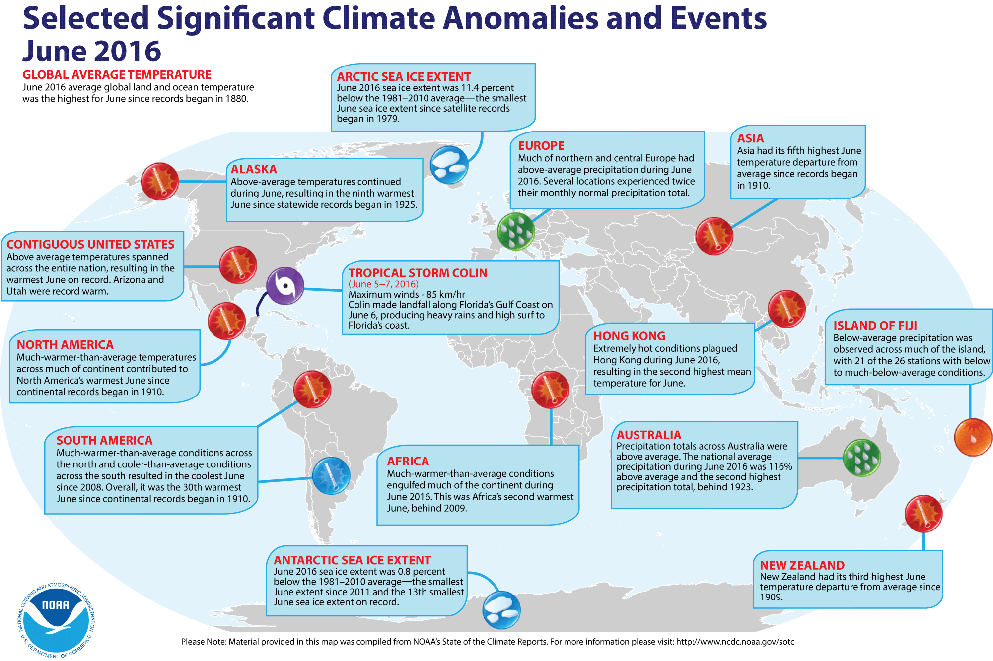
- Global temperature and ice cover for June 2016 reviewed -- Scientists at the NOAA National Centers for Environmental Information (NCEI)
recently reported on their analysis of preliminary weather data collected during the month of June 2016:
- The combined global land and ocean surface temperature for June
2016 was 1.62 Fahrenheit degrees above the 20th
century (1901-2000) average, which was the highest for any month of June since sufficiently detailed global climate records
began in 1880. This June 2016 temperature exceeded the previous June record set last year (2015) by 0.04 Fahrenheit degrees. When considered separately,
the average ocean temperatures for June 2016 was the highest for
any June, while the average land surface temperature for this past month tied June 2015 for the highest June temperature during the 137-year record. Furthermore, the average surface temperatures for land, ocean and combined land-ocean through the first six months of the year (January through June 2016) were the highest for the first half of any year since 1880.
- The researchers at the National Snow and Ice Data Center noted the areal extent of the Arctic sea ice
for June 2015 was
the smallest since satellite surveillance began in 1979. On the
other hand, the extent of the Antarctic sea ice was the thirteenth smallest
in the 38-year record. [NOAA/NCEI
State of the Climate]
- A global map of Selected Significant Climate Anomalies and Events for June 2016 is available from NCEI.
Using their own techniques to analyze the ground-based observations and satellite data, scientists at NASA's Goddard Institute for Space Studies (GISS) also noted that each of the first six months of 2016 set a record as the warmest respective month globally in the modern temperature record dating back to 1880 and that the 6-month (January-June 2016) average temperature was a record high, which is 2.4 Fahrenheit degrees above the late 19th century average. Furthermore, all six months in 2016 with the exception of March had the smallest respective monthly Arctic sea ice extent since consistent satellite records began in 1979. (March 2016 had the second smallest ice extent on record.) [NASA Goddard Space Flight Center Feature]
- Historical records may significantly underestimate global warming trend -- A scientist at NASA's Jet Propulsion Laboratory and colleagues warn that certain peculiarities in how global temperatures have been recorded have resulted in an under representation of the rapidly warming Arctic in historic temperature records due to the fewer historic weather observations in the Arctic. Furthermore, historical data mix air and water temperatures and that early observations were recorded air temperatures over land for the regions that were covered by sea ice. Therefore, the researchers claim that nearly one-fifth of the global air temperature increases that have occurred in the past 150 years has been missed by historical records. The study explains why projections of future climate based solely on historical records estimate lower rates of warming than predictions from climate models. [NASA Earth Science News Team]
- An
All-Hazards Monitor -- This Web portal provides the user information from NOAA's National Weather Service, FAA and FEMA on
current environmental events that may pose as hazards such as tropical
weather, fire weather, marine weather, severe weather, drought and
floods. [NOAA/NWS Daily Briefing]
- Earthweek -- Diary of the Planet [earthweek.com]
Historical Events:
- 25 July 1956...The Italian ship Andrea Doria sank in dense fog near
Nantucket Lightship, MA. Ten hours earlier, the ship was rammed by the
Swedish-American liner, Stockholm, forty-five miles off the coast of
Massachusetts. Fifty-two persons drowned, or were killed by the impact. (David
Ludlum) (The Weather Channel)
- 25 July 1988...A storm system brought heavy rains to Tasmania, Australia. Coastal areas were flooded by high tides and storm surge. (National Weather Service files)
- 25 July 1994...Hurricane Gilma, like Emilia a week earlier, reached
Category 5 strength in the Central Pacific. (Intellicast)
- 26 July 1979...Tropical Storm Claudette stalled over Alvin, Texas, inundating the town with 45 inches of rain in 42 hours. The total included 43 inches in 24 hours, which is the maximum 24-hour rainfall in American history. (National Weather Service files)
- 27 July 1866...The 1686-mile long Atlantic Cable was successfully
completed between Newfoundland and Ireland by the American businessman Cyrus
W. Field, allowing transatlantic telegraph communication for the first time.
Two previous attempts at laying a cable ended in failure. (Wikipedia) (Today
in Science History)
- 27 July 1926...A hurricane came inland near Daytona Beach, FL. The
hurricane caused 2.5 million dollars damage in eastern Florida, including the
Jacksonville area. (David Ludlum)
- 27 July 1943...On a whim, and flying a single engine AT-6, Lieutenant
Ralph O' Hair and Colonel Duckworth were the first to fly into a hurricane. It
started regular Air Force flights into hurricanes. (The Weather Channel)
- 28 July 1819...A small but intense hurricane passed over Bay Saint Louis, MS. The hurricane was considered the worst in fifty years. Few houses were left standing either at Bay Saint Louis or at Pass Christian and much of the Mississippi coast was desolate following the storm. An U.S. cutter was lost along with its thirty-nine crewmembers. The storm struck the same area that was hit 150 years later by Hurricane Camille. (David Ludlum)
- 31 July 1498...On his third voyage to the Western Hemisphere, the explorer Christopher Columbus became the first European to reach the island of Trinidad. (Wikipedia)
- 31 July 1978...A 50-yard wide waterspout came onshore at Kill Devil Hills, NC and destroyed a small house. One person died and four were hurt. Waterspouts are typically considered relatively benign. (Accord's Weather Guide Calendar)
Return to DataStreme Ocean's RealTime Ocean Portal
Prepared by DS Ocean Central Staff and Edward J. Hopkins,
Ph.D.,
email hopkins@aos.wisc.edu
© Copyright, 2016, The American Meteorological Society.