WEEKLY OCEAN NEWS
22-26 May 2017
DataStreme Ocean will return for Fall 2017 with new Investigations files starting during Preview Week, Monday, 21 August 2017. All the current online website products will continue to be available throughout the summer break period.
Items of Interest:
- Twelve steps can create a sustainable high school -- A new activity was made available recently that contains 12 steps schools can use to be more sustainable and environmentally friendly. This tool is available through Connecticut Energy Education. [NOAA Climate.gov News]
- Worldwide GLOBE at Night 2017 Campaign is underway -- The fifth in the series of GLOBE at Night citizen-science campaigns for 2017 will continue through Friday, 26 May. GLOBE at Night is a worldwide, hands-on science and education program designed to encourage citizen-scientists worldwide to record the brightness of their night sky by matching the appearance of a constellation (Leo in the Northern Hemisphere and Crux in the Southern Hemisphere) with the seven magnitude/star charts of progressively fainter stars.
Activity guides are also available. The GLOBE at night program is intended to raise public awareness of the impact of light pollution.
The next series in the 2017 campaign is scheduled for 16-25 June 2017. [GLOBE at Night]
- Higher than normal tide anticipated this coming week along West Coast -- According to the NOAA National Ocean Service's High Tide Bulletin for Spring 2017, higher than average tides are expected on 26 and 27 May for most of the Pacific Coast of the US, stretching southward from Alaska to California. Higher than average tides also can be expected surrounding Hawaii and the US Pacific Islands, along the nation's Atlantic Coast. A new moon occurring on Thursday, 25 May, coupled with the closest lunar perigee of the year occurring one day later when the Moon is closest to Earth is responsible for the perigean spring tide that creates higher than normal high tides. [NOAA National Ocean Service News]
- National Maritime Day will be observed -- Monday, 22 May 2017, has been declared National
Maritime Day, a day created to recognize the maritime
industry. The holiday was created by the United States Congress on 20
May 1933. The date of 22 May was selected because on 22 May 1819, that
the American steamship Savannah set sail from
Savannah, GA on the first ever transoceanic voyage under steam power.
- North American Safe Boating Week -- The 2017 National Safe Boating Week will continue through Friday, 26 May. This week helps launch the 2017 North American Safe Boating Campaign. Check the Safe Boating Week site maintained by the Safe Boating Council.
- Zenithal Sun -- Late this week (25-27 May) marks one of the two times during the year when the noontime sun is directly overhead to residents on Oahu (Honolulu metropolitan area). [US Naval Observatory, Data Services]
Ocean in the News:
- Eye on the tropics --- No tropical cyclones developed in any of the global ocean basins during the last week.
- Unmanned aircraft used to view shipwrecks in Great Lakes marine sanctuary -- Researchers have employed unmanned aircraft to search for shipwrecks and other submerged archaeological artifacts in shallow, unnavigable waters of northern Lake Huron within Thunder Bay National Marine Sanctuary, where at least 200 shipwrecks are located. Systematic, geo-referenced survey missions were conducted using the aircraft during a two-week survey mission in April. [NOAA National Marine Sanctuary News]
- Seabirds in a New England marine sanctuary are tracked by citizen scientists -- Volunteers participated in the seventh annual Stellwagen Sanctuary Seabird Stewards (S4) program last December by counting seabirds as part of an effort to help researchers monitor the ecosystem health of the Stellwagen Bank National Marine Sanctuary, located at offshore of Massachusetts.[NOAA National Marine Sanctuary News]
- Shift in marine species distribution expected to continue as ocean warms -- Using a high-resolution global climate model and historical observations of species distributions between 1968 and 2013 in the shelf waters off the Northeast U.S. coast, scientists with NOAA's Northeast Fisheries Science Center have found that commercially important marine species will continue to shift their distribution as ocean waters warm two to three times faster than the global average through the end of this century. These changes will impact local fishing communities and resource management. [NOAA Fisheries Northeast Fisheries Science Center News]
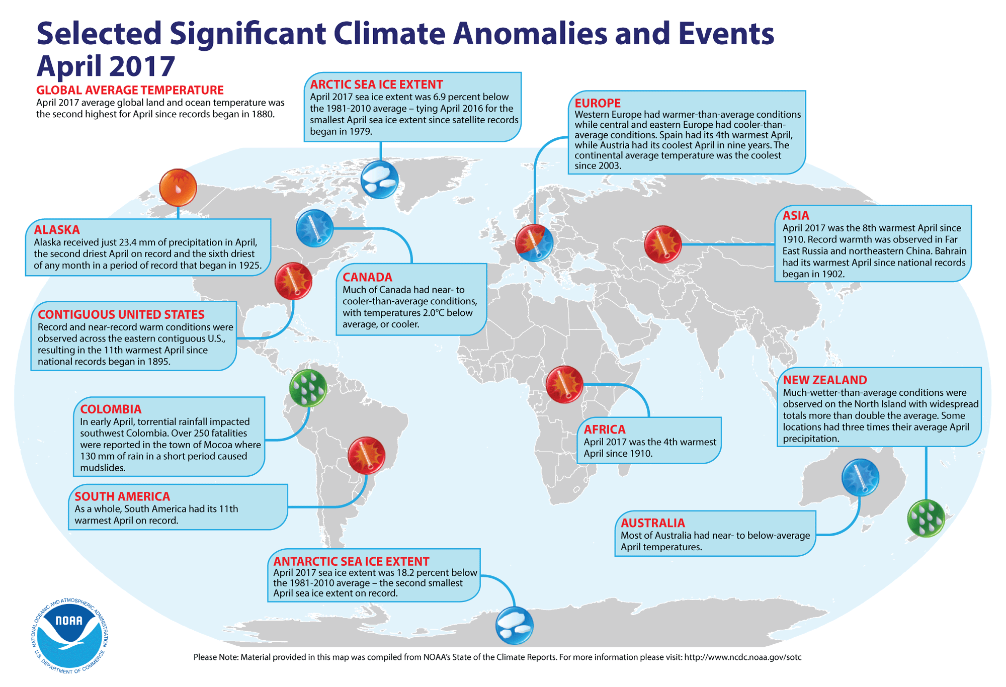
- Global temperatures for April 2017 reviewed -- Using
preliminary data collected from the global network of surface weather
stations, scientists at NOAA's National Centers for Environmental Information (NCEI) report
that the combined global land and ocean surface temperature for April
2017 was the second highest for any April
since comprehensive global climate records began in 1880; this temperature was 1.62 Fahrenheit degrees above the 20th century
(1901-2000) average. Only April 2016 had a larger positive ocean-land temperature departure. The scientists also reported
that when considered separately, the April 2017 average temperature over the
oceans was 1.31 Fahrenheit degrees above the 20th century average, representing the second highest ocean temperature departure on record, while the month's average temperature over the land surfaces was 2.42 Fahrenheit degrees above the long-term average, or the fourth highest April land temperature departure on record.
According to data from the Rutgers Global Snow Lab, the Northern Hemisphere snow cover extent for April 2017 was the 16th largest in the 51-year period of record.
April sea ice extent data
for the Arctic Ocean in 2017 tied April 2016 for the smallest sea ice on record since satellite records began in 1979. The and the sea ice on waters around Antarctica were the second smallest in the satellite era.
A global map of Selected Significant Climate Anomalies and Events for April 2017 is available from NCEI.
[NOAA/NCEI
State of the Climate]
- "Hurricane-Ready Nation" being built one community at a time -- As part of its Flood Prepared Communities initiative, Pew Charitable Trusts, an independent non-profit, non-governmental organization, is working to reduce the human impact and high cost of flooding and rebuilding that typically follow natural disasters in ways that help ensure communities build smarter. Pew Charitable Trusts has teamed with former Charleston (SC) Mayor Joseph Riley to show how the city has addressed increasing storms and sea level rise since it was hit by Hurricane Hugo in 1989 with a 7-minute documentary entitled "After the Storm: Charleston's Blueprint for Disaster Recovery After Hurricane Hugo." [NOAA Weather-Ready Nation News]
- Annual report of the NOAA Climate Program Office for 2016 released -- During the past week NOAA's Climate Program Office (CPO) released its 54-page 2016 annual report that provides an overview of its activities and accomplishments made by this office in climate and ocean observation, research, modeling, and decision support activities for society. [NOAA Climate Program Office News]
- "Year of Polar Prediction" for Arctic, Antarctic weather and sea-ice monitoring about to be launched -- The United Nation's World Meteorological Organization (WMO) will be launching the "Year of Polar Prediction (YOPP)", which is designed to improve predictions of weather, climate and ice conditions in the Arctic and Antarctic. YOPP will run from mid 2017 through mid 2019, to cover at least one complete year in each hemisphere. Currently, relatively little environmental data from the Earth's polar regions are available for use in forecasting. These regions are experiencing large changes due to a changing global climate. During this upcoming YOPP, special observing periods will be added to improve the number of routine observations, for example by weather balloon launches, and buoy deployments from research vessels to measure atmospheric and oceanographic conditions. [UN News Centre]
- Frequency of coastal flooding expected to double globally in next several decades -- Scientists at the US Geological Survey (USGS), the University of Illinois at Chicago and the University of Hawaii recently reported that the frequency and severity of coastal flooding around the world should increase rapidly and eventually double over the coming decades even with only moderate amounts of sea level rise. Thus dramatic increase in coastal flooding results from rising sea levels combined with storm-driven flooding, including the effects of wind driven waves and storm surge. They foresee the increase in flooding will be greatest and most damaging in tropical regions, impairing the economies of coastal cities and the habitability of low-lying Pacific island nations. [USGS News]
- Looking to the ionosphere to improve tsunami warnings -- Scientists from Italy's Sapienza University and NASA's Jet Propulsion Laboratory have developed a new approach called Variometric Approach for Real-time Ionosphere Observation (VARION) to assist in the ongoing development of timely tsunami detection systems. This approach is based upon measurements of how tsunamis in the ocean disturb a part of Earth's ionosphere using observations from GPS and other global navigation satellite systems (GNSS) in near real-time. When a tsunami forms and travels across the ocean, the crests and troughs of its waves compress and extend the air above them, creating internal gravity waves in the atmosphere. The undulations of internal gravity waves are amplified as they travel upward into an atmosphere; when these waves reach the ionosphere (an altitude of between 50 to 621 miles above Earth's surface), they cause detectable changes to the density of electrons in the ionosphere that can be measured when GNSS or GPS signals travel through these tsunami-induced disturbances. [NASA Jet Propulsion Laboratory News]
- Historic ocean data set reveals decrease in dissolved oxygen levels -- Researchers at Georgia Institute of Technology recently found that their analysis of a historic data set of ocean information stretching back more than 50 years indicates levels of dissolved oxygen in the seawater have been declining for more than 20 years. The oxygen levels, an important measure of ocean health, started dropping in the 1980s as ocean temperatures began to rise. Falling dissolved oxygen levels in seawater have the potential to impact the habitat of marine organisms worldwide and in recent years led to more frequent "hypoxic events" that killed or displaced marine species populations.[NCAR/UCAR AtmosNews]
- Crucial marine processes may change due to rising carbon dioxide levels and ocean acidity -- Researchers from Florida State University, Princeton University and China's Xiamen University warn that the acidification of seawater caused by rising atmospheric carbon dioxide levels increases the difficulty for Trichodesmium, a type of cyanobacteria, to perform a process called nitrogen fixation in the oceans. Since Trichodesmium is thought to be responsible for about 50 percent of marine nitrogen fixation, it is critical to the health of hundreds of species in the Earth's oceans as these cyanobacteria convert nitrogen gas into ammonia and other molecules that organisms are dependent on for survival. [Florida State University News]
- An All-Hazards Monitor -- This Web portal provides the user information from NOAA's National Weather Service, FAA and FEMA on
current environmental events that may pose as hazards such as tropical
weather, fire weather, marine weather, severe weather, drought and
floods. [NOAA/NWS Daily Briefing]
- Earthweek -- Diary of the Planet [earthweek.com]
Historical Events:
- 22 May 1819...The steamship SS Savannah left Savannah, GA on a voyage to Liverpool, England and became the
first steamship to cross the Atlantic Ocean. It reached Liverpool on 20
June. (Wikipedia)
- 22 May 1849...The future President, Abraham Lincoln,
received a patent for the floating dry dock described as for "buoying
boats over shoals" (No. 6,469). He was the first American president to
receive a patent. His idea utilized inflated cylinders to float
grounded vessels through shallow water. (Today in Science History)
- 22-24 May 1948...A rare early season hurricane struck the
island of Hispaniola, killing an estimated 80 people. (The Weather
Doctor)
z
- 22 May 1960...A 8.6 magnitude earthquake off the coast of
south central Chile triggered a tsunami that moved across the Pacific
Ocean. Between 490 and 2290 people were estimated to have been killed
by the earthquake and tsunami, and damage estimates were over one half
billion dollars. Hilo, HI was devastated by the tsunami, where 61 fatalities were reported. The
University of Washington)
- 23 May 1850...The US Navy sent USS Advance and USS Rescue to attempt rescue of Sir John
Franklin's expedition, lost in Arctic. (Naval Historical Center)
- 23 May 1946...Commodore Edward M. Webster, USCG, headed the
U.S. Delegation to the International Meeting on Radio Aids to Marine
Navigation, which was held in London, England. As a result of this
meeting, the principal maritime nations of the world would make an
intensive study of the World War II-developed devices of radar, LORAN,
radar beacons, and other navigational aids with a view to adapt them to
peacetime use. This meeting was the first time that the wartime
technical secrets of radar and LORAN were generally disclosed to the
public. (USCG Historian's Office)
- 23 May 1960...Tsunami waves from Chilean earthquakes the previous day began
to affect the Alaska's coast along the Gulf of Alaska from Prince of
Wales Island to Montague Island for as long as one week. The tsunami
waves on the 23rd were up to 14 feet high near Yakutat. (Accord's
Weather Guide Calendar) The tsunami killed killed 61 people in Hilo, HI. An additional 180 people were killed in on the islands of Honshu and Hokkaido in Japan. (National Weather Service files)
- 23 May 2010...A rare tropical cyclone dubbed Bandu brought high winds and heavy rains to Somalia. The storm then moved into the Gulf of Aden where it quickly weakened and dissipated on the 23rd as it passed between Yemen and Somalia. (National Weather Service files)
- 24 May 1500...The 13 ships in the fleet of Portuguese
navigator Pedro Alvares Cabral were hit by a huge ice storm that sank
four ships. The rest of the ships were separated as they sailed south
of the Cape of Good Hope and continued their journey to India.
- 24 May 1901...The relative humidity at Parkstone, Dorset in
England at 4 PM was reported to be 9.5 percent. This low relative
humidity is not typical of the British Islands, which are surrounded by
ocean water and have no large high mountain barriers or plateaus.
(Accord's Weather Guide Calendar)
- 24 May 1951...Northeast gales generated waves to 15 feet
high in the harbor of Newport, RI. A 50-ft. Navy launch with about 142
men on board capsized. Nineteen of the men drowned in the incident.
(Accord's Weather Guide Calendar)
- 24 May 1992...Winds up to 40 knots and seas to 18 feet in
the northern Gulf of Alaska, approximately 30 miles southwest of
Alaska's Cape Cleare, sent three waves crashing over the Cajun
Mama. The 80-ft fishing boat sank, but the crew of five was
rescued. (Accord's Weather Guide Calendar)
- 25 May 1953...In 1953, tropical storms began being named after women. Tropical Storm Alice, which formed near Nicaragua on this date, was the first Atlantic cyclone to be named in this way. (National Weather Service files)
- 25 May 1985...The Meghna River delta in Bangladesh was hit
with a tropical cyclone with winds of over 100 mph that created a 15-to
20-foot high storm surge that flooded a 400-square-mile area, mainly
islands located in the mouth of the river. More than 11,000 people and
500,000 head of cattle died and hundreds of thousands were left
homeless because of this cyclone.
- 26 May 1967...A slow moving nor'easter battered New England
with high winds, heavy rain, and record late season snow on this day
and into the 26th. Winds 70 to 90 mph in gusts occurred along the
coast. Over 7 inches of rain fell at Nantucket, MA with 6.57 inches
falling in 24 hours to set a new 24-hour rainfall record. Severe damage
occurred along the coast from very high tides. The 24.9 inches of snow
that fell at Mount Washington, NH set a new May snowfall record. Other
locations in New Hampshire received 10 inches of snow near Keene and 6
inches at Dublin. (Intellicast)
- 27 May 1774...Sir Francis Beaufort, inventor of the Beaufort Wind Scale, was born in County Meath, Ireland. (National Weather Service files)
- 28 May 1963...A tropical cyclone struck Bangladesh (formerly East Pakistan) killing 11,500 people along
the coast. (National Weather Service files)
- 28 May 1987...A robot probe found the wreckage of the USS Monitor off Cape Hatteras, NC. (Wikipedia)
Return to RealTime Ocean Portal
Prepared by DS Ocean Central Staff and Edward J. Hopkins,
Ph.D.,
email hopkins@aos.wisc.edu
© Copyright, 2017, The American Meteorological Society.