WEEKLY OCEAN NEWS
24-28 July 2017
DataStreme Ocean will return for Fall 2017 with new Investigations files starting during Preview Week, Monday, 21 August 2017. All the current online website products will continue to be available throughout the summer break period.
Items of Interest:
- Shark Week 2017 runs this week --The Discovery Channel's Shark Week 2017, a week-long series of feature television programs dedicated to sharks, started on Sunday evening, 23 July. The week is also promoted on social media networks. Shark Week was first run in July 1987 in an effort to raise public awareness and respect for sharks. Discovery has announced that Michael Phelps, an American former competitive swimmer and the most decorated Olympian of all time, will have a role in Shark Week 2017. [The Discovery Channel]
- Worldwide GLOBE at Night 2017 Campaign is underway -- The seventh in the series of GLOBE at Night citizen-science campaigns for 2017 will continue through Monday, 24 July. GLOBE at Night is a worldwide, hands-on science and education program designed to encourage citizen-scientists worldwide to record the brightness of their night sky by matching the appearance of a constellation (Hercules in the Northern Hemisphere and Scorpius in the Southern Hemisphere) with the seven magnitude/star charts of progressively fainter stars. Activity guides are also available. The GLOBE at night program is intended to raise public awareness of the impact of light pollution. The next series in the 2017 campaign is scheduled for 14-23 August 2017. [GLOBE at Night]
- Zenithal Sun -- Residents of Hawaii's Big Island experienced a
noontime sun that would be directly overhead during this past weekend (22-23 July).
This occurrence of a zenithal sun is one of the two times during the year
when the noontime sun is directly overhead to residents of Hilo and
elsewhere on the Big Island. The other time when the Big Island experienced
a zenithal sun was in mid May [US
Naval Observatory, Data Services]
- NOAA's Teacher at Sea Program is featured -- Since 1990, NOAA has been sending selected kindergarten through college-level teachers to sea through its NOAA's Teacher at Sea Program that is designed to enhance their understanding of scientific research and to provide them with an opportunity to enrich their classroom curricula. A 6-minute video is provided featuring Barney Peterson, one of NOAA's 2016 Teachers at Sea who is an elementary school teacher from near Seattle, WA. [NOAA Teacher at Sea]
- Citizen scientists encouraged to carefully make atmospheric observations during next month's solar eclipse -- With the "Great American Solar Eclipse" being less than four weeks away (Monday, 21 August 2017), the GLOBE Program is encouraging the public to make observations of the atmosphere on the day of the total solar eclipse as it passes from west to east across the nation. The public is invited to make observations of the clouds (type and amount of cover) and air temperature and then post their results using a special GLOBE Observer app. NOTE: Safe eclipse observation techniques are mandatory as looking directly at even a small exposed portion of the Sun during the eclipse can cause serious eye injury. EJH
Additional observations such as surface temperature and other variables such as wind are encouraged. A special eclipse page for educators is available from GLOBE.
[Globe Observer]
Ocean in the News:
- Eye on the tropics --- During the last week several named tropical cyclones were reported over the North Pacific and North Atlantic basins
- In the eastern North Pacific basin, Hurricane Fernanda, which had become a major category 4 hurricane on the Saffir-Simpson Scale over the previous weekend, continued its travels toward the west-northwest away from the coast of Mexico at the start of last week. Over the first half of the week Hurricane Fernanda slowly weakened to tropical storm status by early last Thursday morning. By early Thursday afternoon Tropical Storm Fernanda traveled west across the 140-degree West meridian, the boundary between the eastern and central basins of the North Pacific. Fernanda weakened to a minimal tropical storm early Saturday morning and then a post-tropical tropical remnant low approximately 500 miles to the east of Hilo, HI. Satellite images and additional information on Hurricane Fernanda can be found on the NASA Hurricane Page.
Tropical Depression 7E formed on Monday approzimately 340 miles to the south of Manzanillo, Mexico and then became Tropical Storm Greg early Tuesday morning as it traveled toward the west away from Mexico. Through the remainder of the week, Greg continued its westward track. During its travels toward the west, Greg interacted with Tropical Depression 8E (TD-8E), which had formed off the western coast of Mexico early in the week. Moisture from TD-8E was entrained by the winds encircling Greg. As of Sunday, Tropical Storm Greg was located approximately 1380 miles to the west-southwest of Cabo San Lucas, at the southern tip of Mexico's Baja California Peninsula. During the first two days of this week, Greg should weaken as it curves toward the west-northwest. See NASA Hurricane Page for additional information for Tropical Storm Greg.
A third tropical depression of last week (Tropical Depression 9E, or TD-9E) formed last Friday approximately 500 miles to the south-southeast of Puerto Angel, Mexico. Moving to the west-northwest, TD-9E strengthened to become Tropical Storm Hilary by Saturday evening.
As of Sunday, Tropical Storm Hilary was located approximately 460 miles to the south-southeast of Manzanillo, Mexico. Current forecasts indicate that Hilary should continue traveling to the west-northwest on Monday and Tuesday, with intensification to a hurricane anticipated.
Tropical Depression 10E (TD-10E) formed approximately 600 miles to the south-southwest of Cabo San Lucas this past Saturday morning.
Traveling toward the west, TD-10E had strengthened to become Tropical Storm Irwin, the fifth named tropical cyclone of July 2017 in the eastern Pacific, early Sunday morning. Later Sunday, Irwin was located approximately 670 miles to the southwest of Cabo San Lucas. Strengthening of Tropical Storm Irwin was anticipated, possibly becoming a hurricane by Tuesday.
- In the western North Pacific basin, Tropical Storm Talas made landfall along the northern coast of Vietnam approximately 170 miles to the south of the capital city of Hanoi on Monday (local time). Talas quickly weakened into a remnant low as it moved to the west across Vietnam and toward Laos before dissipating.
See additional information and satellite images on Tropical Storm Talas on the NASA Hurricane Page.
The next named tropical cyclone to develop in the western North Pacific last week was Tropical Storm Noru that strengthened from a tropical depression located to the north-northwest of Wake Island. After forming at the midpoint of last week, Tropical Storm Noru intensified to become a typhoon as it traveled westward late last week. Over this past weekend, Noru had strengthened to become a category 2 typhoon (on the Saffir-Simpson Scale) as maximum sustained surface winds were estimated to have reached at least 98 mph. Noru represents the first typhoon of 2017 in the western North Pacific basin. As of late Sunday Typhoon Noru was located approximately 300 miles to the north-northeast of Minami Tori Shima (Marcus Island). Current forecasts indicate that Typhoon Noru should reverse course, heading toward the east-southeast through Tuesday before curving toward the north and then northwest during the mid to late week. Additional information on Typhoon Noru are available on the NASA Hurricane Page.
A third named tropical cyclone developed last week in the western North Pacific as Tropical Storm Kulap strengthened from a tropical depression that was located to the southwest of Midway Atoll. Kulap traveled generally toward the west during the second half of last week. As of late Sunday, Tropical Storm Kulap was located approximately 840 miles to the north of Wake Island. Tropical Storm Kulap was projected to travel toward the west-northwest and weaken to become a tropical depression during the first several days of this week. Satellite imagery and additional information are available on the NASA Hurricane Page for Tropical Storm Kulap.
Tropical Storm Roke formed from a tropical depression late last week over the waters of the western Pacific to the southeast of Taiwan. Roke was the fourth named tropical cyclone of last week.
Over the weekend, Roke traveled toward the northwest and west-northwest through the Luzon Strait, which separates Taiwan from the Philippines. As it traveled, Roke weakened to become a tropical depression. On Sunday Tropical Depression Roke had reached to within 40 miles to the east of Hong Kong. Roke was expected to continue weakening as it passes just to the north of Hong Kong and into southeastern China.
The fifth named tropical cyclone of last week in the western North Pacific was Tropical Storm Sonca, which formed from a tropical depression called Tropical Depression 8W (TD-8W) located to the southeast of China's Hainan Island. Over the weekend Tropical Storm Sonca traveled toward the west-northwest. As of late Sunday, Sonca was located approximately 240 miles to the east-northeast of Da Nang, Vietnam. Tropical Storm Sonca was forecast to continue traveling toward the west-northwest, making landfall on Hainan Island by midweek. Consult the NASA Hurricane Page for additional information on Tropical Depression 8W, which became Tropical Storm Sonca.
- In North Atlantic basin the fourth named tropical cyclone of 2017 for that basin formed last Monday afternoon as Tropical Storm Don roughly 500 miles to the east of the Windward Islands. Over the next day Tropical Storm Don traveled westward. As Don approached the Windward Islands, bands of torrential rain and gusty winds accompanying the storm spread across the islands.
Don became an remnant low late Tuesday night over the waters of the far southeastern Caribbean Sea approximately 55 miles to the west-southwest of Grenada.
The NASA Hurricane Page has satellite images and additional information for Don.
- Wreckage of crab fishing vessel located in waters off Alaska -- Using a multibeam sonar designed for seafloor mapping and object detection, the NOAA Ship Fairweather, a hydrographic survey vessel, was able to locate the wreckage of the fishing vessel Destination in approximately 250 feet of water off St. George Island, AK in early July. The Destination was lost with its six crew members in mid-February while fishing for snow crab in the Bering Sea off the Pribilof Islands. A U.S. Coast Guard dive team aboard Coast Guard Cutter Healy will use a remotely operated vehicle to investigate the wreckage within the next two weeks. The discovery by the Fairweather was made after the NOAA Ship Oscar Dyson, a fisheries survey vessel, had made an earlier survey of the region in late April. [NOAA News]
- Describing NOAA's support of ocean exploration and data collection -- The efforts of NOAA's Office of Ocean Exploration and Research (OER) to catalog and provide access oceanic data obtained from NOAA's Okeanos Explorer are described in an article posted on the National Centers for Environmental Information (NCEI) website. The Okeanos Explorer is NOAA's 224-ft long exploratory vessel that is equipped with cameras designed to provide real-time viewing of the ocean floor for scientists and for the public as part of its mission of gathering scientific information about oceans. Currently, a NCEI scientist is working in the vessel's wet lab as it is exploring the deepwater areas of the Pacific Ocean near the Johnston Atoll. NCEI is providing oceanographic and meteorological data obtained from its current expeditions on its website called "Okeanos Explorer Atlas." In addition, the "OER Digital Atlas" and the "OER Video Portal" are being prepared as data and video archives from over 260 OER missions. [NOAA NCEI News]
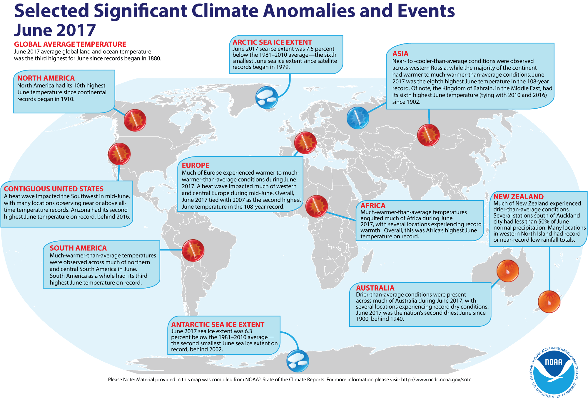
- Global temperature and ice cover for June 2017 reviewed -- Scientists at the NOAA National Centers for Environmental Information (NCEI)
recently reported on their analysis of preliminary weather data collected during the month of June 2017:
- The combined global land and ocean surface temperature for June
2017 was 1.48 Fahrenheit degrees above the 20th
century (1901-2000) average, which was the third highest temperature for any month of June since sufficiently detailed global climate records
began in 1880. When considered separately,
the average ocean temperatures for June 2017 was the third highest for
any June, while the average land surface temperature for this past month was the fourth highest June land temperature during the 138-year record.
Furthermore, the average combined land-ocean temperature through the first six months of the year (January through June 2017) was the second highest for the first half of any year since 1880, falling nearly 0.3 Fahrenheit degrees below the record set one year ago (Jan-June 2016).
- The researchers at the National Snow and Ice Data Center noted the areal extent of the Arctic sea ice
for June 2017 was
the sixth smallest for the month since satellite surveillance began in 1979. In addition, the extent of the Antarctic sea ice was the second smallest
in the 39-year record. [NOAA/NCEI
State of the Climate]
A global map of Selected Significant Climate Anomalies and Events for June 2017 is available from NCEI.
Using their own techniques to analyze the ground-based observations and satellite data to obtain a spatial average temperature, scientists at NASA's Goddard Institute for Space Studies (GISS) noted that the global composite temperature for June 2017 was the fourth-highest since 1880. (NOTE: The temperature anomalies, or arithmetic differences between current observed and a long-term average is based upon the 1951-1980 averaging interval, which differs from the 1901-2000 interval used by NCEI. EJH) [NASA Global Climate Change Feature]
- An All-Hazards Monitor -- This Web portal provides the user information from NOAA's National Weather Service, FAA and FEMA on
current environmental events that may pose as hazards such as tropical
weather, fire weather, marine weather, severe weather, drought and
floods. [NOAA/NWS Daily Briefing]
- Earthweek -- Diary of the Planet [earthweek.com]
Historical Events:
- 24 July 1609...A fleet of ships carrying colonists to the New World met
with a hurricane near Bermuda, resulting in much loss of property but little
loss of life. (Northern Indiana NWSFO)
- 24-25 July 1979...Claudette, a weak tropical storm, deluged southeastern
Texas with torrential rains. The Houston suburb of Alvin received 43.00
inches, a 24-hour precipitation record for not only the Lone Star State, but
for the U.S. Freeport reported a total of 30 inches. Total damage from
flooding was over $400 million. On the 27th, a van loaded with
people on their way to a church camp stopped on Texas Highway 7 due to a
flooded bridge just west of Centerville. A truck rammed the van, pushing it
into the flooded creek, resulting in five people drowning. (Intellicast)
(David Ludlum) (NCDC) (Accord's Weather Guide Calendar)
- 24-26 July 1996...Although thousands of miles from southern California, an
intense South Pacific storm south of Tahiti produced seven- to ten-foot surf
with some sets up to 12 feet along the southern California coast. Lifeguards
participated in more than 500 rescues along the beaches. (Accord's Weather
Guide Calendar)
- 25 July 1956...The Italian ship Andrea Doria sank in dense fog near
Nantucket Lightship, MA. Ten hours earlier, the ship was rammed by the
Swedish-American liner, Stockholm, forty-five miles off the coast of
Massachusetts. Fifty-two persons drowned, or were killed by the impact. (David
Ludlum) (The Weather Channel)
- 25 July 1988...A storm system brought heavy rains to Tasmania, Australia. Coastal areas were flooded by high tides and storm surge. (National Weather Service files)
- 25 July 1994...Hurricane Gilma, like Emilia a week earlier, reached
Category 5 strength in the Central Pacific. (Intellicast)
- 26 July 1979...Tropical Storm Claudette stalled over Alvin, Texas, inundating the town with 45 inches of rain in 42 hours. The total included 43 inches in 24 hours, which is the maximum 24-hour rainfall in American history. (National Weather Service files)
- 27 July 1819...Several dozen people were killed in the Bay St. Louis Hurricane. Some of the fatalities were from alligator and snake bites when the animals were driven into the streets of Mobile, AL. (National Weather Service files)
- 27 July 1866...The 1686-mile long Atlantic Cable was successfully
completed between Newfoundland and Ireland by the American businessman Cyrus
W. Field, allowing transatlantic telegraph communication for the first time.
Two previous attempts at laying a cable ended in failure. (Wikipedia) (Today
in Science History)
- 27 July 1926...A hurricane came inland near Daytona Beach, FL. The
hurricane caused 2.5 million dollars damage in eastern Florida, including the
Jacksonville area. It had been a Category 4 hurricane when it crossed the Bahamas. (David Ludlum)
- 27 July 1943...On a whim, and flying a single engine AT-6, Lieutenant
Ralph O' Hair and Colonel Duckworth were the first to fly into a hurricane. It
started regular Air Force flights into hurricanes. (The Weather Channel)
- 28 July 1819...A small but intense hurricane passed over Bay Saint Louis, MS. The hurricane was considered the worst in fifty years. Few houses were left standing either at Bay Saint Louis or at Pass Christian and much of the Mississippi coast was desolate following the storm. An U.S. cutter was lost along with its thirty-nine crewmembers. The storm struck the same area that was hit 150 years later by Hurricane Camille. (David Ludlum)
- 30 July 1997...Two waterspouts moved onshore in northern Virginia Beach, VA. One tracked into Norfolk. (National Weather Service files)
Return to RealTime Ocean Portal
Prepared by DS Ocean Central Staff and Edward J. Hopkins,
Ph.D.,
email hopkins@aos.wisc.edu
© Copyright, 2017, The American Meteorological Society.