Research:
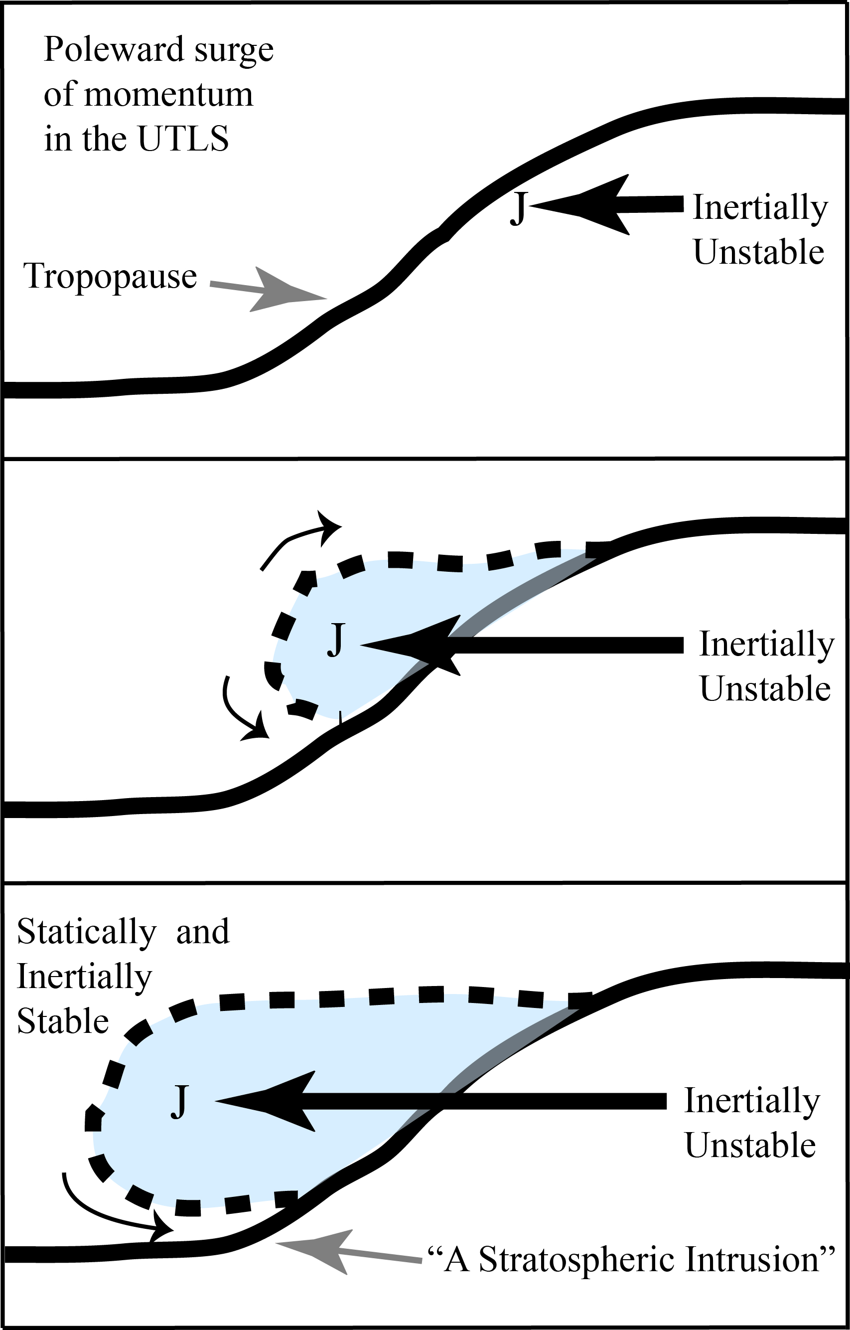
My research investigates inertial instability dynamics and its impacts in the midlatiudes and tropics. More specifically we have shown that inertial instability plays a key role in stratosphere-troposphere exchange and poleward momentum surges.

Figure taken from Rowe and Hitchman (2015). Schematic diagram of a stratospheric intrusion formed by relative motion, in this case a poleward surge of air in the UTLS (time increases downward). Inertial instability aids the poleward intrusion of air, as the jet strengthens and moves poleward, over- riding a thin layer of stratospheric air. The heavy dashed line in- dicates the displaced tropopause and is a locus of enhanced divergence–convergence and mixing of air. Recirculation around the nose of the poleward surge may aid filamentation of the in- trusion, as suggested by the small arrows. Eventually, the lightness and inertial stability of the extratropical lower stratosphere limits further poleward motion.
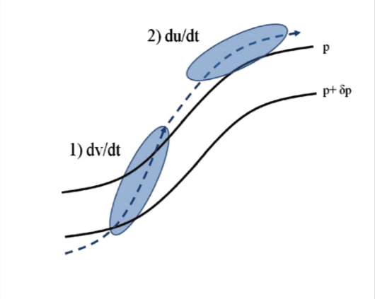
We have developed the hypothesis that inertial instability can act as a prime mover and facilitate poleward displacement of a wind speed maximum. We have attempted to visualize the effects of inertial in- stability on synoptic-scale flows. Consistent with considerations of the horizontal momentum equations following the motion, it is found that inertial instability leads to 1) acceleration of poleward motion, followed by 2) acceleration of the zonal flow. That is, inertial instability can cause a poleward displacement of the jet maximum.

Figure taken from Rowe and Hitchman (2016). Idealized diagram of the relationship between inertial instability and zonal jet flare-ups in the upper troposphere. In the inertially unstable stage 1, the meridional flow accelerates down the meridional pressure gradient (two pressure contours shown) in the presence of weak zonal flow (negative ageostrophic flow). In stage 2, the zonal flow accelerates because of the Coriolis torque on the strong meridional flow in the presence of a weak zonal pressure gradient. Inertial instability can facilitate poleward displacement of a zonal wind maximum and contribute to the shape of the ridge.
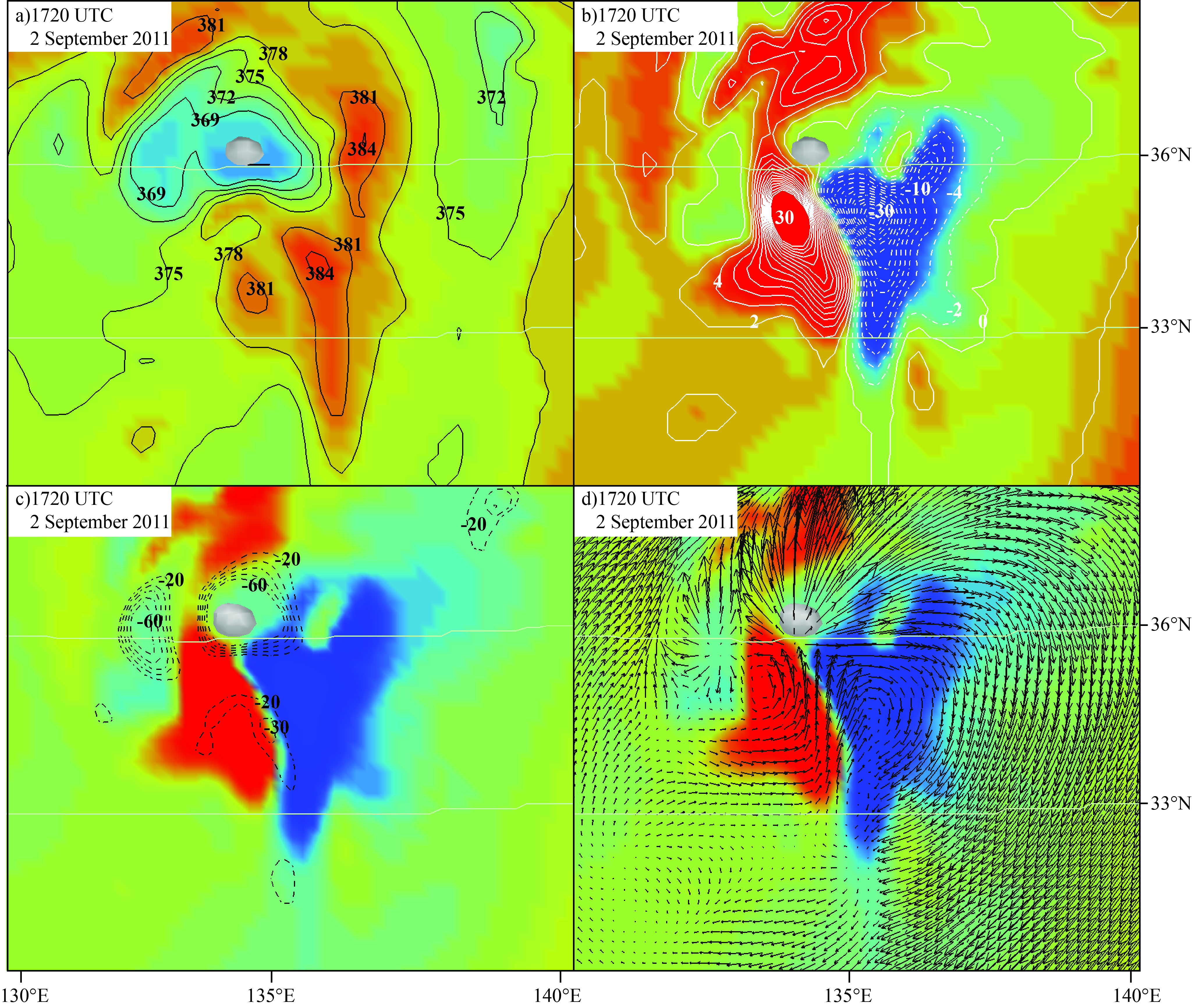
We are currently studying how potential vorticity dipoles form a top deep convective towers in tropical and midlatitude deep convection. More specifically the figure below shows a potential vorticity and the associated theta-e dipole associated with a deep convective tower above typhoon Talas (2011) in Japan.

Figure taken from Rowe and Hitchman (2017) submitted. Plan views at 16.5 km on 1720 UTC 2 September 2011 near the updraft centered at 866 33N, 135E (white isosurface of 50 cm/s upward motion) in the UWNMS simulation of Talas of 867 a) θe (black contours and color, with blue < 372 K and red > 390 K), b) EPV in PVU units (white 868 contours and shading, red is strongly positive and blue is negative), c) as in b) with divergence 869 (black dashed contours with interval 1x10⁻⁵ s-1from 1-10 x10-5 s-1 ), and d) as in b) with 870 horizontal wind vectors (largest vector is 40 m/s).
For more information regarding this work please visit our Inertial Instability Research Webpage